
|
Original published in D.F. Merriam, ed., 1964, Symposium on cyclic sedimentation: Kansas Geological Survey, Bulletin 169, pp. 249-263 | |
1Brown University, Providence, Rhode Island; 2Columbia University and The American Museum of Natural History, New York, New York
Cyclic deposits of the northern Midcontinent rarely are adequately interpreted by the application of various transgressive-regressive phase hypotheses. Very often lateral facies analyses are required to understand fully the genesis of the lithologic and biologic attributes of these deposits. The phase approach emphasizes the "basinal" aspects of the depositional environment in that it invokes a migrating shoreline across a sedimentary basin, accompanying transgression and regression, as the explanation for the changes in sediment types and fossil assemblages.
This paper seeks to emphasize, through the facies approach, "banklike" aspects of the depositional environment where local hydrographic factors cause lithologic and biologic differentiation of contemporaneons facies.
Three examples from the recent literature (Hattin, 1957; Imbrie and others, 1959, and Laporte, 1962; and Wanless and others, 1963) are discussed in terms of each approach, and it is demonstrated that elements of both approaches are necessary to the ultimate understanding of these cyclic deposits.
[Note: We gratefully acknowledge financial lupport of a National Science Foundation grant (G-4535).]
One objective in the study of sedimentary rocks is the interpretation of their origin in terms of the primary depositional environment. Much of the progress that has been made toward this objective in the northern Midcontinent region is based on the identification of cyclothems and their analysis in relation to transgressive and regressive phases of deposition. Important inferences can also be made by identifying lateral variations in rock units and analyzing these facies in terms of paleogeography and hydrography. The main purpose of this paper is to emphasize the need to integrate phase and facies studies. Facies analyses are required not only because they yield otherwise unobtainable evidence bearing on the origin of ancient rocks and fossils, but also because they provide a necessary check on interpretations based on phase study alone.
Orderly vertical sequences of repeating rock types and fossil assemblages are well known. These depositional cycles can be interpreted in terms of a depositional model--the basin model--in which both depth and distance from shore are related in a simple way to sediment type and organism community, and in which rate of transgression and regression are slow enough to provide a recognizable sedimentary record of the migrating environments. Although modern examples of this type of basin are known, other parts of the modern ocean illustrate contrasting properties--the bank model. Study of Pennsylvanian and Permian examples from the Midcontinent indicates that elements of both models can be identified in many stratigraphic units. Both phase and facies studies must, therefore, be carried out before satisfactory interpretations can be made. Unaided, phase studies offer an effective way of arriving quickly at a useful but limited level of understanding of rock origins and should take their place ultimately as a supplement to facies studies. Phase studies, however, offer the primary approach to important questions concerning the genesis of depositional cycles.
Studied in vertical sections, Pennsylvanian and Lower Permian rocks exposed in the northern Midcontinent region reveal a marked tendency for rock layers of different aspect to be arranged in orderly successions which are frequently repeated. The discovery, description, and interpretation of these cyclic deposits form a major contribution to historical geology. Classic papers by Elias, Moore, Wanless, and Weller are so well known that it is unnecessary to restate here the essentials of the cyclothem thesis. In the remainder of this paper we are not concerned with trying to refute this work, but are interested in stressing the need for the facies approach as an independent and complementary study of the same rocks. We certainly do not claim this as a revolutionary and new concept. Geographic variations in the nature of cyclothems are well known--although regional, rather than local, variations are generally considered.
The phase approach to the understanding of depositional environments involves a specific hypothesis about conditions under which the deposits accumulated. Usually the attributes of this hypothetical or model situation are implicit rather than explicit. For example, Moore (1959, p. 49) states, "the local small stratigraphic sections showing these paleontological features furnish the record of paleontologically different conditions on the shallow sea bottom that were introduced at the locality of the section as the sea gradually became deeper, or (probably more important) as the shoreline became farther and farther distant" (itaiics ours). Figure 1 illustrates this interpretation of Pennsylvanian cycles in Kansas.
Figure 1--Pennsylvanian cyclic deposits in Kansas and their explanation according to basin model of deposition (from Moore, 1959).
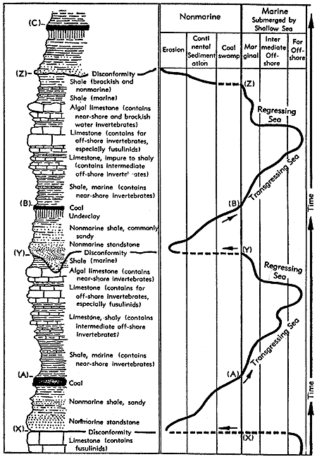
Four points regarding this model are worth noting. First, it is assumed that sedimentary facies and organism communities bear a simple relationship to water depth and distance from shore. Second, it is assumed that depth and distance from shore bear a simple relationship to each other. Third, it is assumed that the rate of transgression (or regression) is slow enough so that under local conditions of sedimentation and subsidence a recognizable stratigraphic record will be formed. Fourth, the resulting stratigraphic record will show lateral and vertical facies changes reflecting each stage in the transgression. The lateral facies changes will proceed approximately at right angles to the shoreline; the vertical facies changes will record temporal variation in shoreline position.
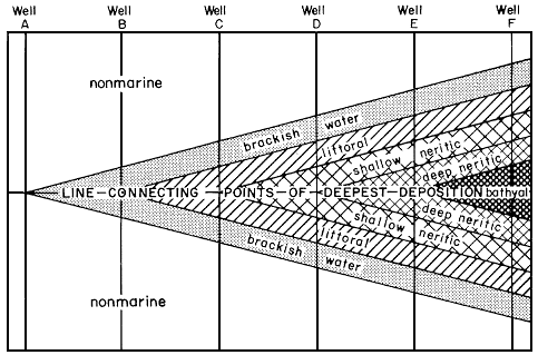
During significant parts of the Cenozoic these conditions have existed along the northern margin of the Gulf of Mexico, as illustrated by Israelsky (1959) and others (Fig. 2). The geologic factors responsible for what is here called the basin model of cyclical deposition are not hard to identify in the Gulf of Mexico. They include rapid subsidence along a basin margin, stream and river activity, rapid sedimentation rate, and a relatively steep but simple bathymetric profile offshore.
Figure 2--Idealized dip section of a sedimentary cycle in Gulf Coast (from Krumbein and Sloss, 1951, after Israelsky, 1949).
In shallow waters of the Great Bahama Bank the conditions of deposition form a striking contrast to those identified in the basin model. Instead of rapid sinking along a basin margin, there is slow subsidence of an essentially flat, platform-shaped area. Major rivers are completely absent, and the supply of silicate detritus is nil. In the words Moore (1959) used to describe Midcontinent conditions during the late Paleozoic, the Great Bahama Bank is a nearly flat platform "just awash." Almost all of this area, which covers tens of thousands of square miles, lies at depths shallower than 24 feet, and most of it is less than 18 feet. Although depth variations are small in magnitude, those which do occur are significant in facies genesis.
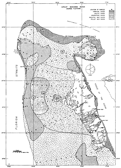
Three aspects of Bahama Bank sedimentation are worth noting here. Documentation for them is furnished in papers by Newell and others (1959), Cloud (1962), Purdy (1963), and Streeter (1963). First, neither the sedimentary facies nor the organism communities bear a simple relationship to water depth or to distance from shore (Fig. 3). The four major sediment facies described by Purdy, for example, may all be found just below intertidal depths, and the mud facies is found over the complete depth range known on the Bank proper, 0 to 36 feet. The same four facies types may also occur near a shoreline or 60 miles offshore. The true controls over the facies pattern are related to mass circulation rate and level of turbulence, factors which are in turn complex functions of the geography and hydrography of the Bank as a whole.
Figure 3--Sedimentary facies of Andros platform of Great Bahama Bank (from Purdy, 1963). A larger version of this figure is available.
Second, depth and distance from shore do not bear a simple relationship to each other. Closed depressions and offshore shoals are a common feature of the ocean bottom and strongly influence the nature of the bottom sediments and organism communities.
Third, although our knowledge of the stratigraphy of these Bahamian deposits is meager, it is already clear that the record does not show a simple pattern of the Gulf Coast type. Since the Bank was flooded about 5,000 years ago, some 5 to 10 feet of sediments have accumulated as a "transgressive sequence."
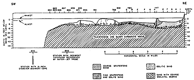
Detailed coring and water-jet probing in the Frazers Hog Cay area of the Great Bahama Bank by Imbrie and Buchanan reveal a pattern of carbonate facies of the bank type (Fig. 4). Immediately above the irregular karst Pleistocene limestone lies a thin veneer of carbonate sand with abundant molluscan remains. This shell-rich layer is the stratigraphic record of the initial flooding of the Bank by the post-Pleistocene eustatic rise in sea level. The superjacent carbonate sediment includes oolite sand on the seaward margin which interfingers laterally with bankward deposits of grapestone sand. These oolite and grapestone facies are interpreted as local reponses to the hydrographic conditions on the Bank. Depth alone does not explain the facies pattern; rather, distance from the oceanic reservoir, water turbulence, and water circulation are the dominant influences. Independent work by Cloud (1962) confirms this interpretation, for, in the mud areas west of Andros Island, his cores are essentially similar from top to bottom.
Figure 4--Stratigraphy of Recent sediments of Frazers Hog Cay area, B.W.I. Vertical section of a southwest-northeast traverse located between Northwest Channel Light and Frazers Hog Cay on northeast margin of Great Bahama Bank (see, Figure 3). Open ocean to left (southwest); bank interior to right (northeast). Data from field studies by John Imbrie and Hugh Buchanan. A larger version of this figure is available.
Apparently then, the rate of transgression has been rapid enough so that the dominant portion of the Bahamian post-Pleistocene stratigraphic record is related to local conditions at the site of sedimentation rather than to a particular transgressive phase of a depositional cycle.
The facts of Bahamian sedimentation and stratigraphy outlined above form the basis of what is here called the bank model of sedimentation. Its characteristic features are a nearly flat area at or below sea level in which the depositional record at anyone place and time reflects primarily the local basinal hydrography rather than a particular phase in a completely recorded cycle of transgression or regression.
It is not to be expected, of course, that either the bank or the basin method of cyclic deposition would be found in pure form in any geologic deposit. We take them, rather, as theoretical extremes, elements of which can be recognized at given localities and for given stratigraphic units. This point of view is illustrated in the paragraphs below where three published examples are examined.
In both kinds of transgression lateral and vertical facies changes will occur. In the basin type they are directly related to the shifting strandline. In the bank type they may be later than the transgression and are related to the overall geometry and topography of the inundated basin. If the basinal model applies, the vertical sequence should be repeated laterally when going at right angles to the ancient shore.
Detailed studies of this Lower Permian unit have been published by Imbrie and others (1959; and this volume), and by Laporte (1962). Figure 5 shows the major conclusions of these studies. The question here arises: Does this stratigraphic pattern fit the classic cyclothem theory? The answer is an ambiguous "yes and no." Remembering that the shale units above and below the Beattie--the Stearns and Eskridge Shales--contain red and green shales, and scattered thin coals, we may conclude that the gross aspect of these units, Eskridge/Beattie/Stearns, is clearly identifiable as a nonmarine/marine/nonmarine cycle. We can also recognize, at certain places, fragments of Elias' generalized sequence of phases. Between localities 3 and 12, for example, calcareous brachiopods are conspicuous elements of the fauna immediately above the fusuline phase; and near locality 31 there is an association of Osagia and shelly facies which corresponds approximately with Elias' idea that the calcareous algae are closely related to the molluscan phase. But we look in vain for a clear cyclic pattern of sedimentation in which the upper part of the Beattie is a mirror image of the lower. (The single exception to this is at localities 30 and 44 where the limestones above and below the Florena Shale show considerable similarities to each other.) According to the phase theory, moreover, the fusuline-bearing unit should be the plane of symmetry. In the Beattie, two sets of fusuliniferous strata are known, neither of which forms a plane of symmetry.
Figure 5--Beattie Limestone facies. See text in Imbrie and others (this volume) for explanation. A larger version of this figure is available.
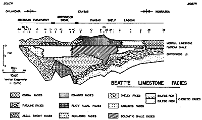
We may therefore conclude that the phase model of cyclical sedimentation is a fruitful explanatory concept for only part of the Beattie cyclothem, and that the processes responsible for most of this stratigraphic record can be better understood in terms of the facies model. Once this approach is followed, many features of the stratigraphy become clear which would otherwise be obscure. For example, the facies patterns of all three members of the Beattie strongly indicate that a major control of sediments and biotas is by a circulation barrier (the Greenwood Shoal) centered around localities 13, 40, 41, and 42. The fauna and lithology of the shelly facies, localization of the platy algal facies, position of the dolomite facies, carbonate-pebble conglomerate of the algal breccia facies, and many other features of these units are elucidated by the facies approach.
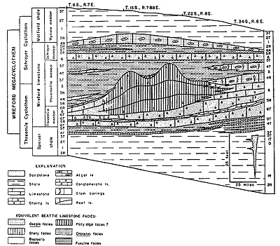
The excellent study of the Wreford megacyclothem (Lower Permian of Kansas) by Hattin (1957) may be cited to demonstrate the useful combination of phase and facies analysis in interpreting cyclic deposits. Hattin's Figure 6 which is reproduced here (Fig. 6) provides an effective summary of his work. Here, we see a definite cyclic tendency in the arrangement of rock types and fossil assemblages (with three different expressions of the cycle in northern, central, and southern Kansas), and the phase model is a significant aid in interpretation. Certain noncyclic elements are present, however, and for these the facies approach is more revealing. The molluscan limestones (which are equivalent to the Beattie's shelly facies) occur much more prominently in the southern part of Hattin's study area, with a single thin bed extending northward across the state. This arrangement recalls the distribution of the shelly facies in the Beattie, where a more effective barrier prevented the facies from extending northward altogether. The lateral change in thickness and character of the Threemile Limestone Member in central Kansas (analogous to the thickening and change of the Cottonwood Limestone over the Greenwood Shoal) is interpreted by Hattin as a reeflike bank formed by algae and bryozoans; an interpretation that results from facies rather than phase study. It is also significant that the Osagia algal limestone occurs both as nearshore tongues and as a regressive capping of the limestone sequence--a facies pattern confirming interpretation made from cyclic position alone.
Figure 6--Facies and phases in Wreford megacyclothem (modified from Hattin, 1957). Note that phases are more symmetrical than facies patterns suggest. Numbers refer to phases of deposition. A larger version of this figure is available.
Wanless and others (1963) have published regional environmental maps for many detailed stages of three Pennsylvanian cycles. These maps, which cover portions of Oklahoma, Kansas, Missouri, Iowa, Illinois, and Indiana, represent an impressively large-scale application of the facies approach in which lateral variations are studied in plan rather than along a single line of section. Examined individually and in sequence, these maps form a reliable basis for interpreting both cycles and sediments. They may also be used to judge the applicability of the basin and bank models of deposition formulated above. For illustrative purposes here, 5 maps representing two phases of the Summum and Brereton cyclothems have been reproduced (Fig. 7, 8, 9, 10, 11).
Figure 7--Environmental map of Breezy Hill Limestone and equivalent beds of Summum cyclothem (from Wanless and others, 1963). A larger version of this figure is available.
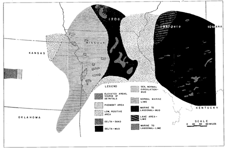
Figure 8--Environmental map of Summum No. 4A coal and equivalent beds of Summum cyclothem (from Wanless and others, 1963). A larger version of this figure is available.
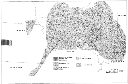
Figure 9--Environmental map of Vermilionville Sandstone and equivalent beds of Brereton cyclothem (from Wanless and others, 1963). A larger version of this figure is available.
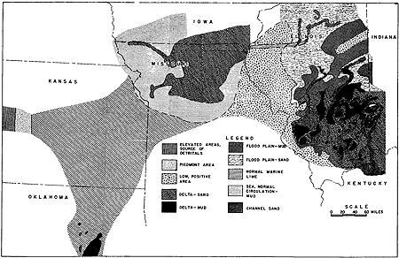
Figure 10--Environmental map of No. 5A coal and equivalent beds of Brereton cyclothem (from Wanless and others, 1963). A larger version of this figure is available.
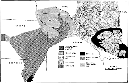
Figure 11--Environmental map of limestone interval above No. 5A coal and equivalent beds of Brereton cyclothem (from Wanless and others, 1963). A larger version of this figure is available.
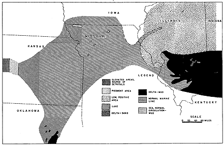
From scrutiny of all 29 published maps it is clear that important elements of both postulated models can be identified. Two elements characteristic of the basin model are worth noting. First, for some portions of the mapped area during parts of some cycles, orderly sequences of contemporary facies transgress or regress as predicted from cyclothem theory. Deposits in northern Missouri, for example, show marine shale and limestone transgressing in proper order over a deltaic sand (Fig. 9, 10, 11). For this and similar sequences, the phase approach is a useful explanatory concept. Second, rivers contribute relatively large amounts of silicate detritus in two areas.
Two elements characteristic of the bank model can also be identified. First, rapid transgressions of marine limestones and black shales occur over wide areas. The Blackjack Creek Limestone and Excello Shale (not shown on figures reproduced here) are good examples of this phenomenon. As Wanless and others note (p. 456), "a 3-10 foot limestone may spread as much as 700 miles across a recently submergent area." Second, in many instances, features of the local hydrography clearly exercise a dominant control over the type of deposit. As the hydrography is, in turn, a complex function of tectonic movements, local and regional sea-level changes, and rates of sediment deposition and accumulation, a simple, repeating series of cyclic phases can hardly be expected. To illustrate this point, contrast the depositional sequence and pattern leading to the Summum No. 4A coal, Summum cyclothem (Fig. 7, 8), with the No. 5A coal of the Brereton cyclothem (Fig. 9, 10,11). As noted by Wanless and others (p. 444, 448), these coals have contrasting depositional antecedents, occupy positions in opposing hemicycles, and have their geographic position determined by local hydrographic features. They manifestly cannot be explained by mere assignment to positions in a sequence of cyclic phases. The Summum coal is regressive, follows the deposition of a variety of marine and deltaic muds, and is situated in two areas that may be interpreted as tectonic swales. The No. 5A coal, on the other hand, is transgressive and follows deposition of sand on a delta platform.
The full range of lithologies and fossil assemblages of northern Midcontinent cyclic deposits of late Paleozoic age is not adequately explained by the classic hypotheses of transgression and regression of the seas in this area. Equally important, as lateral facies analyses of these units demonstrate, is a companion hypothesis which stresses the importance of local hydrographic control in facies genesis and differentiation.
Cloud, P. E., Jr., 1962, Environment of calcium carbonate deposition west of Andros Island, Bahamas: U. S. Geol. Survey Prof. Paper 350, 138 p. [available online]
Hattin, D. E., 1957, Depositional environment of the Wreford megacyclothem (Lower Permian) of Kansas: Kansas Geol. Survey Bull. 124, 150 p. [available online]
Imbrie, John, Laporte, L. F., and Merriam, D. F., 1959, Beattie Limestone facies and their bearing on cyclical sedimentation theory: Kansas Geol. Soc. 24th Field Conf. Guidebook, p. 69-78.
Israelsky, M. C., 1949, Oscillation chart: Am. Assoc. Petroleum Geologists Bull., v. 33, p. 92-98.
Krumbein, W. C., and Sloss, L. L., 1951, Stratigraphy and sedimentation: W. H. Freeman and Co., San Francisco, 497 p.
Laporte, L. F., 1962, Paleoecology of the Cottonwood Limestone (Permian), northern Mid-Continent: Geol. Soc. America Bull., v. 73, p. 521-544.
Moore, R. C., 1959, Geological understanding of cyclical sedimentation represented by Pennsylvanian and Permian rocks of the northern Mid-Continent region: Kansas Geol. Soc. 21st Field Conf. Guidebook, p. 46-55.
Newell, N. D., Imbrie, John, Purdy, E. G., and Thurber, D. L., 1959, Organism communities and bottom facies, Great Bahama Bank: Am. Mus. Nat. Hist. Bull., v. 117, p. 177-228.
Purdy, E. G., 1963, Recent calcium carbonate facies of the Great Bahama Bank: Jour. Geology, v. 71, p. 334-355, 472-497.
Streeter, S. S., 1963, Foraminifera in the sediments of the northwestern Great Bahama Bank: Unpub. doctoral dissertation, Columbia Univ., 228 p.
Wanless, H. R., Tubb, J. B., Gednetz, D. E., and Weiner, J. L., 1963, Mapping sedimentary environments of Pennsylvanian cycles: Geol. Soc. America Bull., v. 74, p. 437-486.