![]()
Prev Page--Geography, Geology || Next Page--Geomorphology
Geologic Formations in Relation to Ground Water
Cretaceous System
Dakota Formation
General description--The term Dakota group (Meek and Hayden, 1862) was first applied to the sandstones, varicolored clays, and lignite beds that underlie the "Benton group" in exposures near Dakota City, Dakota County, Nebraska. As used in this report, the Dakota Formation includes that part of the Cretaceous section between the Kiowa Shale below and the Graneros Shale above (Moore and others, 1951, fig. 11, p. 25). The Dakota Formation as defined by the State Geological Survey of Kansas has been referred to variously as "Dakota group" (Meek and Hayden, 1862); "Dakota sandstone" (Prosser, 1897); "Dakota formation" (Twenhofel, 1924); "Rocktown channel sandstone member" (Rubey and Bass, 1925); "Cockrum sandstone" (Latta, 1941, p. 73); and "Omadi formation" (Condra and Reed, 1943, p. 14, 18).
Plummer and Romary (1942) described the Dakota Formation as about 75 percent varicolored clay containing irregular lenticular beds of siltstone and sandstone. In north-central Kansas thin lignite beds are present in the upper 25 feet of the Dakota Formation (Schoewe, 1952, p. 87, fig. 4), and pellets of iron in the form of siderite or ankerite and concretions of limonite seem to be a distinguishing characteristic of the formation (Plummer and Romary, 1942, p. 326-339). The Dakota Formation probably represents deposits formed in a dominantly continental and littoral environment, whereas the underlying and overlying shales were deposited in a marine environment. The sandstones are thin bedded to massive, generally crossbedded, and may be ripple marked. Fine-grained sandstone predominates, but the grain size ranges from silt (smaller than 0.062 mm) to very coarse sand (1.0 to 2.0 mm). The coarser-grained sandstones are the channel sandstones, which are somewhat more common in the upper part of the Janssen Clay member of the formation but may be found at any stratigraphic position. Many of the sandstone bodies are loosely cemented with limonite, some are uncemented, and others are tightly cemented with calcium carbonate, silica, or iron. Studies of surface exposures indicate that some of the sandstone lenses are small but others may be several square miles in extent. Many sandstones are not interconnected, as indicated by differences in hydrostatic pressure of the water that they contain. Frye and Brazil (1943, p. 53) reported that as many as six sandstones have been penetrated by one test hole, but it is also possible to drill through the entire thickness of the Dakota Formation without penetrating any sandstone.
Frye and Brazil (1943, table 3) gave the thickness of the Dakota Formation in Ellis and Russell Counties as 200 to 300 feet, Swineford and Williams (1945, p. 116) stated that in southwestern Russell County it is 213 to 300 feet thick, and Latta (1950, p. 61) indicated that it is 200 to 300 feet thick in the northern part of Barton County. Well cuttings from the Carl Ruder No. 1 oil well in the NE NW sec. 17, T. 15 S., R. 18 W., indicate that the Dakota Formation is about 155 feet thick in the central part of the area. The formation underlies all the area, but only the uppermost part is exposed, in the NW sec. 35, T. 15 S., R. 16 W., where it arches over the axis of a northeastward-trending fold called the Pfeifer Anticline by Bass (1926, p. 36).
Water supply--The Dakota Formation is the principal source of water in much of the upland of the report area. Many wells between Big Creek and Smoky Hill River in southeastern Ellis County, south of Smoky Hill River in southeastern Ellis County and northern Rush County, north of the Pfeifer Terrace west of Antonino, and west of the Smoky Hill School in southwestern Ellis County obtain moderate supplies of water for domestic and stock use from the Dakota. Information on 27 wells, ranging in depth from 108 to 350 feet, is given in Table 11. In addition, a few wells south of Smoky Hill River in southeastern Trego County are reported to obtain water for stock use from the Dakota Formation at depths exceeding 500 feet; however, these wells were not inventoried during this investigation.
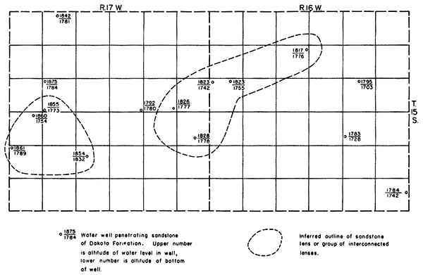
No wells in the Dakota Formation in the area were reported to yield large supplies of water, but elsewhere wells penetrating thick sandstones in the Dakota Formation have large yields (Latta, 1950, p. 61, table 12). The sandstone lenses in the Dakota Formation contain ground water under artesian pressure, but differences in hydrostatic pressure from well to well indicate that the sandstone lenses may not be interconnected. For example, the water level in well 15-17-15dd has an altitude of 1,792 feet, whereas the water level in well 15-17-14dd, only a mile away, has an altitude of 1,826 feet. Some lenses may extend throughout several square miles (Fig. 5) as indicated by the close similarity of water levels in wells 15-16-9aa, 15-16-18ab, 15-16-18bb, 15-17-14dd, and 15-17- 24dc. Possibly these wells penetrate a series of interconnected sandstones rather than a single lens of wide lateral extent, but the relation of water levels suggests a connected hydrologic system among the wells. The source, movement, and occurrence of artesian water in the Dakota Formation are discussed more fully in the section on artesian conditions.
Figure 5--Inferred area of some lenses of sandstone in Dakota Formation in southeastern Ellis County.
The quality of water from wells penetrating the Dakota Formation differs considerably from well to well. In general, water in the Dakota Formation is more mineralized than water in the unconsolidated rocks. The concentrations of iron, sodium, fluoride, and chloride generally are high, and in some places the concentration of sulfate is high, but generally the hardness is moderate. In 11 water samples collected from wells penetrating sandstones of the Dakota Formation, total dissolved solids ranged from 388 to 4,950 ppm (Tables 4, 7). In general, water from the deeper sandstones seems to be more mineralized than that from the shallower sandstones (Frye and Brazil, 1943, table 12). Some of the areas in which there are no wells (Pl. 2), as in southeastern and southwestern Ellis County, are areas in which water in the Dakota Formation is reported to be too mineralized for domestic and stock use. The quality of water in the Dakota Formation is discussed more fully in the section on chemical character of water.
Graneros Shale
The Graneros Shale was named by Gilbert (1896) from exposures along Graneros Creek 20 miles southwest of Pueblo, Colorado. The name was first used in Kansas by Logan (1897) for the noncalcareous beds at the base of the "Benton" group in central Kansas. The Graneros Shale was described and mapped in Russell County by Rubey and Bass (1925) and in Ellis County by Bass (1926). The Graneros Shale lies conformably between the Dakota Formation below and the Greenhorn Limestone above. The shale underlies all the area except part of the Smoky Hill Valley in southeastern Ellis County where the Dakota Formation crops out or lies directly beneath Pleistocene deposits.
The Graneros Shale consists of about 40 feet of noncalcareous blue-black to brownish-black shale. Generally it is thin bedded and where weathered has a fissile appearance. Thin layers of limonite, limonitic and pyritic concretions, flakes of ochre, and selenite crystals are common. Locally, coquina forms lenses near the top, and a prominent bentonite bed about 15 inches thick lies just below the top of the formation. Frye and Brazil (1943) noted sandstone lenses in the Graneros Shale, and some of the sandstone bodies may be of sufficient thickness and areal extent to yield water to wells. The Graneros Shale does not yield water to wells in this area, however.
The following section, measured along Smoky Hill River in Russell County east of the report area, illustrates the character of the Graneros Shale:
| Measured section of Graneros Shale and upper part of Dakota Formation in SE sec. 18, T. 15 S., R. 15 E., Russell County. | Thickness, feet |
|||
|---|---|---|---|---|
| 25. | Lincoln Limestone member of Greenhorn Limestone | |||
| Graneros Shale | ||||
| 24. | Shale, noncalcareous, fissile, black | 1.2 | ||
| 23. | Bentonite, massive. creamy white | 1.0 | ||
| 22. | Limestone, composed of pelecypod shells | .2 | ||
| 21. | Shale, non calcareous, fissile, black | 2.2 | ||
| 20. | Coquina. brown, containing many fossil pelecypods and alternating with thin gray and brown shale beds | 1.4 | ||
| 19. | Shale, noncalcareous, fissile, dark gray; contains thin sandstone streaks | 4.4 | ||
| 18. | Ironstone and siltstone, hard, rusty; contains gypsum crystals | .5 | ||
| 17. | Shale, noncalcareous, fissile, dark gray | 2.4 | ||
| 16. | Alternating thin beds of sandstone and shale, noncalcareous, gray | 3.7 | ||
| 15. | Shale, non calcareous, fissile, dark gray; contains many thin gray sandstone layers | 2.8 | ||
| 14. | Sandstone, gray and rusty brown; contains thin shale streaks and thin limestone layers | 1.0 | ||
| 13. | Shale, non calcareous, fissile, dark gray | 1.8 | ||
| 12. | Shale, non calcareous, fissile, dark gray; contains several silty "shell beds" containing many fossil pelecypods | 2.5 | ||
| 11. | Shale, noncalcareous, fissile, gray and black, containing lemon-yellow streaks | 1.0 | ||
| 10. | Sandstone, shaly, rusty, lemon yellow, and gray | 0.4 | ||
| 9. | Shale, noncalcareous, fissile, gray; contains some sand in lower part and selenite crystals throughout | 4.8 | ||
| 8. | Sandstone, iron cemented, gray and yellow, shaly in middle part; forms small ledge on slope | 1.8 | ||
| 7. | Shale, noncalcareous, fissile, slightly sandy, brown to black; contains selenite crystals | 3.3 | ||
| 6. | Sandstone, friable, gray; contains "ironstone" at top; 100 feet east thickens to 6 feet | .6 | ||
| 5. | Shale, noncalcareous, fissile, brown, black, and maroon; contains thin streaks of sand in lower part and selenite crystals in upper part | 3.3 | ||
| Total measured thickness of Graneros Shale | 40.3 | |||
| Dakota Formation | ||||
| 4. | Sand, loose, gray, buff, and rusty; contains black carbonaceous streaks and thin "ironstone bands" | 2.5 | ||
| 3. | Shale, carbonaceous, fissile, brown to black; contains streaks of gray sand | .6 | ||
| 2. | Sandstone, limonitic in upper part, gray to rusty yellow; contains black clay streaks | 1.0 | ||
| 1. | Clay, sandy, irregularly bedded, black and gray streaked; extends to Smoky Hill River flood plain | 2.0 | ||
| Total measured section | 46.4 | |||
Greenhorn Limestone
General description--Gilbert (1896) named the Greenhorn Limestone from exposures of interbedded limestone and shale near Greenhorn station and along Greenhorn Creek, about 15 miles south of Pueblo, Colorado. Tentative correlations of the Colorado section with central Kansas rocks referred to as "Benton" were made by Logan (1897, p. 232). Rubey and Bass (1925), in Russell County, were the first to use the Greenhorn Limestone as a mapping unit in Kansas. They subdivided the Greenhorn Limestone into four members in ascending order: The Lincoln Limestone member, an unnamed shale member, the Jetmore Chalk member, and an unnamed upper shale member. In 1926 Bass recognized the same subdivisions in Ellis County but named the lower shale member the Hartland Shale and the upper shale member the Pfeifer Shale. In central Kansas the uppermost unit of the Greenhorn Limestone is the "Fencepost" Limestone bed; the Greenhorn is bounded at the base by the noncalcareous shale beds of the Graneros Shale. The upper part consists chiefly of interbedded thin chalky limestone and calcareous shale and contains thin bentonite seams (Pl. 5A, B). The middle part of the formation is mainly calcareous shale containing a few concretionary limestone layers and thin bentonite seams. Calcareous shale interbedded with thin, dark, crystalline limestone containing shark teeth and other vertebrate remains also predominates in the lower part. The basal limestone beds are "petrolifero us" and emit a strong petroleum odor when broken open. Bass (1926) gave the thickness of the Greenhorn Limestone as about 100 feet, but only the upper part is well exposed in much of the report area. The following section, measured in the SW sec. 22 and SE sec. 21, T. 15 S., R. 17 W., illustrates the character of the upper part of the Greenhorn Limestone:
| Measured section of upper Greenhorn Limestone at type locality of Pfeifer Shale member in SW sec. 22 and SE sec. 21, T. 15 S., R. 17 W. | Thickness, feet |
|||
|---|---|---|---|---|
| Cretaceous--Gulfian | ||||
| Carlile Shale | ||||
| Shale, yellow; contains surficially chalky discoidal concretions | ||||
| Greenhorn Limestone--Pfeifer Shale member | ||||
| 41. | "Fencepost" Limestone bed, hard, dense; contains brown ironstain in center | 0.8 | ||
| 40. | Shale, calcareous, white and buff; contains bentonite streak 0.7 foot below top and concretionary limestone 1.3 feet below top | 3.0 | ||
| 39. | Limestone, concretionary | .3 | ||
| 38. | Shale, calcareous, buff | 1.3 | ||
| 37. | Limestone, dense, persistent, even bedded, gray buff, weathers chalky | .1 | ||
| 36. | Shale, calcareous, gray in upper part, buff in lower part; contains limonite in upper part and concretionary limestone at base | .95 | ||
| 35. | "Sugar sand"-calcite sand, white, buff, and orange; contains vertically oriented calcite prisms at base | .3 | ||
| 34. | Shale, calcareous; contains concretionary limestone layers 0.5 foot and 2.2 feet above base | 4.0 | ||
| 33. | Limestone, concretionary; contains many shells | .4 | ||
| 32. | Shale, calcareous, gray, weathers white; contains zones of concretionary limestone containing shells 0.7 foot and 1.4 feet above base | 2.3 | ||
| 31. | Limestone, chalky, gray buff, persistent; contains Inoceramus shells | .3 | ||
| 30. | Shale, calcareous, fissile, gray, weathers chalky and buff; contains limonitic zone at top and concretionary limestone layers 0.9 foot and 1.6 feet above base | 3.1 | ||
| 29. | Limestone, concretionary, gray and orange; contains Inoceramus shells | .3 | ||
| 28. | Shale, fissile, calcareous, gray and white; basal part more massive, dark gray | 3.5 | ||
| Jetmore Chalk member | ||||
| 27. | "Shell rock" limestone, white to light buff; upper surface irregular; contains many Inoceramus shells | 1.0 | ||
| 26. | Shale, chalky; contains concretionary limestone layers 0.8 foot and 1.5 feet above base | 3.0 | ||
| 25. | Limestone, hard; forms small ledge; contains shells | .35 | ||
| 24. | Shale, chalky, white | 1.0 | ||
| 23. | Limestone, chalky, gray white, weathers orange; contains Inoceramus shells | .5 | ||
| 22. | Shale, calcareous, white, weathers chalky; contains bentonite streaks at base | .82 | ||
| 21. | Chalk, massive; contains Inoceramus shells | .4 | ||
| 20. | Shale, calcareous; contains 0.25-foot chalk bed 1.0 foot above base and bentonite streak 1.4 feet above base | 2.05 | ||
| 19. | Chalk, weathers brown | .3 | ||
| 18. | Shale, chalky | .9 | ||
| 17. | Chalk, weathers rusty brown | .5 | ||
| 16. | Shale, calcareous | 2.0 | ||
| 15. | Chalk, massive, gray | .4 | ||
| 14. | Shale, calcareous; contains 0.25-foot chalk bed in center | 2.65 | ||
| 13. | Chalk, massive, hard, weathers orange | .4 | ||
| 12. | Shale, chalky, dark gray, weathers blue gray; contains 0.25-foot chalk bed in center | 2.75 | ||
| 11. | Limestone, massive, gray, hard | .4 | ||
| 10. | Shale, calcareous, black | .2 | ||
| 9. | Bentonite, orange | .08 | ||
| Hartland Shale member | ||||
| 8. | Shale, chalky, gray; contains thin bentonite bed 0.7 foot above base and limonitic zone 3.1 feet above base | 5.5 | ||
| 7. | Limestone, chalky, gray | .4 | ||
| 6. | Shale, chalky, gray | 3.6 | ||
| 5. | Shale, calcareous; contains limonitic zone in center and several thin chalky limestone beds | 3.5 | ||
| 4. | Limestone, chalky | .3 | ||
| 3. | Shale, calcareous, white to gray | 1.6 | ||
| 2. | Bentonite, white and orange; contains limonitic concretions in center | .5 | ||
| 1. | Shale, calcareous, thin bedded, gray; contains two chalky limestone beds 0.35 foot thick, one at top and one 0.8 foot above base. Down to level of small creek | 3.6 | ||
| Total measured thickness of Greenhorn Limestone | 59.35 | |||
Plate 5--A, Alternating limestone and calcareous shale of Jetmore Chalk and Hartland Shale members of Greenhorn Limestone in stream bank near NW cor. sec. 27, T. 15 S., R. 17 W.; B, Closeup of lower part of section shown in A, showing 6-inch layer of bentonite (marked by hammer head); C, Fissile noncalcareous shale of Blue Hill Shale member of Carlile Shale, containing large calcareous concretions, near NW cor. sec. 2, T. 15 S., R. 21 W.
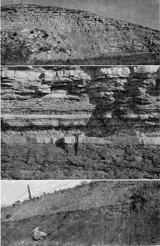
In southeastern Ellis County the uppermost layer of the Greenhorn Limestone, the "Fencepost" Limestone bed, has been quarried extensively to supply fence posts and building stone. In that area the "Fencepost" is massive, contains many Inoceramus shells, and has a faint ironstain through the center. It is about 10 inches thick and on fresh exposures is soft and chalky.
Water supply--In general, the chalky limestone and shale that compose the Greenhorn Limestone are impervious and do not yield water to wells. Locally, where the upper part of the limestone lies at relatively shallow depth and is subject to weathering, it may contain openings large enough to hold small amounts of water. Although two or three wells in the area of this report may obtain water from the upper part of this limestone or from weathered shale (Carlile) overlying the limestone, the Greenhorn Limestone has little importance as an aquifer.
Carlile Shale
General description--The Carlile Shale was named by Gilbert (1896) from exposures of gray argillaceous shale along Arkansas River near Carlile Station west of Pueblo, Colorado. Logan (1897, p. 232) compared Gilbert's section with the rocks lying below the Niobrara Chalk in Kansas and suggested their correlation. Rubey and Bass (1925) used the Carlile Shale as a mapping unit in Russell County where they separated it into two members, the Blue Hill Shale above and the Fairport Chalky Shale below. Bass (1926, p. 28) applied the same names to geologic mapping units in Ellis County; he also named and described the Codell Sandstone zone in the upper part of the Blue Hill Shale member from exposures along Saline River in northern Ellis County.
The Carlile Shale consists of about 300 feet of shale between the top of the "Fencepost" Limestone bed of the Greenhorn Limestone and the base of the overlying Niobrara Chalk. In general, the Carlile Shale is not well exposed, although parts of nearly all the section can be seen along the bluffs of Smoky Hill River in southwestern Ellis County. The lower 100 to 115 feet of the formation is calcareous and is classed as the Fairport Shale member. The lower part of the Fairport Shale member resembles the upper part of the Greenhorn Limestone and consists of alternating beds of calcareous shale and thin chalky or concretionary limestone containing thin bentonite seams in the basal 20 feet. The shale beds are bluish gray in fresh exposures but weather to a sticky yellow clay containing many Ostrea shells. "Ostrea Shale" was the term applied to this unit by Logan (1897). The Fairport Shale member underlies most of the broad plain between the valleys of Big Creek and Smoky Hill River in southeastern Ellis County.
The upper 175 feet of the Carlile is classed as the Blue Hill Shale member. Most of it is blue-gray fissile argillaceous shale that contains selenite crystals and Hakes of bright yellow ochre. A lenticular sandstone or zone of sandy shale in the upper part is referred to as the Codell Sandstone zone (Moore and others, 1951, p. 24). Zones of calcareous concretions, both septarian and ordinary, characterize the upper 50 feet of the Blue Hill Shale member (Pl. 5C). The concretions may be spherical, ellipsoidal, or discoidal and contain intersecting veins of brown calcite that stand out in relief on weathering. They range in diameter from a few inches to as much as 3 feet and are in well-defined zones, which are well exposed on the steep slopes below the escarpment of the Niobrara Chalk. In the lower part of the member thin concretionary limestone beds and layers of rusty-brown discoidal concretions may occur. The Blue Hill Shale member is well exposed only on the steep slopes below the Niobrara escarpment where the shale has been eroded into "bad lands", such as the area south of Smoky Hill River in southwestern Ellis County.
Water supply--In general, the Fairport Shale member is impervious chalky shale and yields little or no water to wells. In northwestern Ellis County the Codell Sandstone zone yields water to wells in an area of several square miles, but in the southern part of the county it is too thin and too argillaceous to serve as an aquifer. The Blue Hill Shale member is impervious and does not yield water to wells.
Niobrara Chalk
General description--The Niobrara Chalk was named in 1862 by Meek and Hayden from exposures of chalky marl and shale along Missouri River near the mouth of Niobrara River in northern Nebraska. In 1897 Logan described the Niobrara Chalk in western Kansas and divided it into two members: the upper part, the Pteranodon beds, or Smoky Hill Chalk; and the lower part, the Fort Hays Limestone, named from a locality on the old Fort Hays military reservation just west of Hays. In 1925 the stratigraphy of the Niobrara Chalk in Russell County was described in detail by Rubey and Bass, and in 1926 Bass described and mapped the formation in Ellis County.
The lower 55 to 60 feet of the formation is a white massive chalk called the Fort Hays Limestone member in Kansas. It is resistant to erosion and forms a pronounced escarpment, which extends southward across Kansas from Jewell County to Arkansas River. This escarpment has been used to mark the boundary between the High Plains and the Dissected High Plains (Schoewe, 1949, fig. 22). In the area of this report, only the lower 30 or 40 feet of the Fort Hays Limestone member is present in the bluffs south of Smoky Hill River near Cedar Bluff dam. Just west of Hays, the Fort Hays Limestone member and the lower beds of the Smoky Hill Chalk member form the divide between Big Creek and Smoky Hill River. According to Landes and Keroher (1939, p. 13), the thickness of the Niobrara Chalk in Logan, Gove, and Trego Counties is about 700 to 800 feet, but all except the lower part has been removed by erosion in this area. An excellent exposure of the Fort Hays Limestone member may be seen in sec. 1, T. 15 S., R. 22 VV., where the limestone was quarried for use in construction of the Cedar Bluff dam. Although it has been quarried at several localities for building stone, the Fort Hays stone may be somewhat inferior to the "Fencepost" for buildings.
Water supply--The Niobrara Chalk is impervious and does not yield water to wells in this area.
Neogene System--Pliocene Series
Ogallala Formation
Tertiary rocks have been recognized in the western part of Kansas since the earliest geologic work in the state. Mudge (1878, p. 53) classed these rocks as Pliocene and described them briefly. Haworth (1897b) also described their lithology and structure. In 1899 Darton named and described the Ogallala Formation in Nebraska from a locality that he later (1920, p. 6) stated was near Ogallala Station in southwestern Nebraska. Johnson (1901, 1902) described the geology and ground-water supply of the High Plains, including the western part of Kansas, and Bass (1926) mapped and described the Ogallala Formation in Ellis County.
Small remnants of the Ogallala Formation (Pliocene) lie unconformably on the Niobrara Formation in the western part of the area shown on Plate 1. In northern Ellis County the Ogallala Formation consists of about 75 feet of sand, gravel, silt, and clay loosely cemented in part with limy material to form "mortar beds" (Bass, 1926, p. 16). In southwestern Ellis County all except a few feet has been removed by erosion.
In the report area the Ogallala Formation lies above the water table and does not yield water to wells.
Neogene System--Pleistocene Series
Classification--The Pleistocene classification system of the Kansas Geological Survey is based on the classification of glacial deposits developed in the Midcontinent region (Frye and Leonard, 1952, p. 28-52). The Kansas system deviates from other systems, however, by including the Recent as a stage within the Pleistocene instead of as a separate series. Although the nearest glacial deposits are more than 150 miles northeast of this area, excellent correlations have been made between the two areas. The eolian and alluvial deposits of the nonglaciated parts of Kansas and Nebraska have been correlated with the glacial section on the basis of continuous loesses and their included molluscan fauna, buried soil profiles, and petrologically distinctive volcanic ash (Condra, Reed, and Gordon, 1947; Frye, Swineford, and Leonard, 1948).
In the area of this report, stream deposits representing the Nebraskan(?), Kansan, Illinoisan, and Wisconsinan stages have been recognized near the Smoky Hill Valley. The undifferentiated Pleistocene deposits mapped near Big Creek valley (Pl. 1) are believed to include deposits of Nebraskan, Kansan, and Illinoisan age, but it was not feasible during this investigation to attempt to map them separately. Wisconsinan and Recent deposits occur along both Smoky Hill River and Big Creek, but were mapped together on Plate 1. Stream-deposited silt of Sangamonian age (Loveland Formation) borders the Smoky Hill Valley, and thin eolian silts of Sangamonian (Loveland) and Wisconsinan (Peoria) age are spread over upland areas. Because they are thin and discontinuous, the eolian silts were not mapped. The stream deposits fill channels cut into bedrock and form terraces along the principal streams. Successively younger deposits unconformably overlie or are channeled into older deposits. The classification of Pleistocene deposits in this area is given in Figure 6.
Figure 6--Chart showing classification of Pleistocene deposits in southern Ellis County and southeastern Trego County.
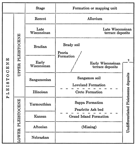
The classification of Pleistocene deposits used in this report has evolved mainly since 1948, although the terrace deposits of Pleistocene age were recognized much earlier in the area of this report. Rubey and Bass (1925, p. 19) and Bass (1926, p. 16) noted the broad terrace along Smoky Hill River and tentatively correlated the terrace deposits with the "McPherson Formation" of Pleistocene age. Frye, Leonard, and Hibbard (1943) studied in detail several exposures of the terrace deposits and decided the deposits were continuous with the "Equus beds" or the McPherson Formation of the McPherson region. In 1948, Frye, Swineford, and Leonard used the distinctive Pearlette Ash and associated snail fauna to extend the correlation of the midcontinent glacial section into the Great Plains. They showed that the deposits associated with the Pearlette volcanic ash, including the McPherson "Equus beds", part of the terrace deposits along Smoky Hill River, and other stream and basin deposits in Kansas were Late Kansan and Yarmouthian in age, and they applied the term "Meade Formation" to those deposits. The detailed field work for the present report produced evidence showing conclusively that the body of terrace deposits along Smoky Hill River is principally Illinoisan in age and that the Kansan and Yarmouthian deposits studied by Frye and others is only a very minor part of the deposits.
The classification used in this report was adopted by the Kansas Geological Survey in 1959. The terms Grand Island, Sappa, Crete, and Loveland Formations have been used for deposits of the same ages in Nebraska for many years. These names have been used in Kansas reports to apply to deposits of identical ages for about 15 years, but were previously designated "members" (Frye and Fent, 1947; Frye and Leonard, 1949; Fent, 1950).
Deposits of Nebraskan(?) age
General description--The oldest Pleistocene deposits in the area are remnants of stream-deposited channel fill tentatively classed as Nebraskan in age. About 15 feet of sand and gravel consisting of chalk pebbles, mortar-bed fragments, pebbles of "Algal limestone", and reworked crystalline material from the Ogallala Formation, loosely cemented with limy material, cap the elongated northwestward-trending ridge on which Antonino is built (Pl. 6B). Similar material, 3 to 7 feet thick, overlies the Carlile Shale and underlies late Pleistocene loess along U. S. Highway 183 in the north bluff of Smoky Hill River in the NW NW sec. 27 and NE NE sec. 28, T. 15 S., R. 18 W. Other stream deposits probably of Nebraskan age crop out north and northwest of Victoria (Pl. 6A). Those deposits have been mapped with the undifferentiated Pleistocene deposits.
Plate 6--A, Cemented crossbedded conglomerate of Nebraskan(?) age in NE SW sec. 30, T. 13 S., R. 16 W.; B, Silty gravel of Nebraskan(?) age exposed in road cut in NW NE sec. 2, T. 15 S., R. 19 W.
The Nebraskan(?) deposits near Antonino contain a large amount of material derived from the Ogallala Formation and only a small amount of material derived from Cretaceous rocks. Some of the deposits northwest of Victoria contain a large percentage of locally derived chalk material, suggesting that they may have been deposited by small streams tributary to the main stream that deposited the main mass of sand and gravel, which is strongly crossbedded and locally in the lower part cemented with calcium carbonate (Pl. 6A). Nebraskan(?) deposits occupy a topographic position midway between the Ogallala Formation and Kansan deposits. Fragments of material from the Ogallala Formation contained in the Nebraskan(?) deposits indicate that they must be younger than the Ogallala Formation, and the calcium carbonate content helps to distinguish them from the Kansan deposits. Bass (1926, p. 16) recognized the Pleistocene age of material near Victoria, but Frye and Brazil (1943, p. 28) tentatively assigned it to the Tertiary System, although they noted that it was younger than the Ogallala Formation. No fossils have been found in the Nebraskan(?) deposits, and the tentative age assignment is based on its topographic position and relation to the formations for which definite age determinations have been made.
Water supply--A shallow ground-water reservoir in Nebraskan(?) deposits along the Antonino ridge supplies many domestic water wells in Antonino and several wells along the ridge on each side of the village (Pl. 2, Table 11). The outcrops of the Nebraskan(?) deposits near Victoria may be one of the areas of local recharge to the main ground-water reservoir in the undifferentiated pleistocene of the area. Well 15-16-21bd in southeastern Ellis County taps water from surficial materials that probably are of Nebraskan age.
Grand Island and Sappa Formations
General description--The Grand Island and Sappa Formations, along Smoky Hill River in southeastern Trego County and southwestern Ellis County, are restricted to a narrow channel about one-fourth mile wide cut into the Carlile Shale (Pl. 4A). The location of this channel, which has a meander pattern much like that of the modern river, is shown in Figure 7 as plotted from surface exposures (Pl. 7B, C), test-holes and wells drilled into it, springs and seeps where tributary streams intersect it, and small undrained depressions in the material overlying it. The base of this channel is a few feet below the level of the present river bed.
Figure 7--Kansan-age channel and terraces in southeastern Trego County and southwestern Ellis County.
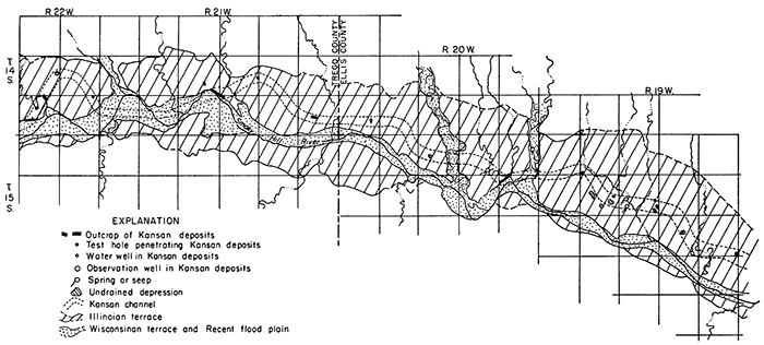
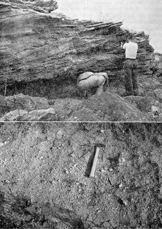
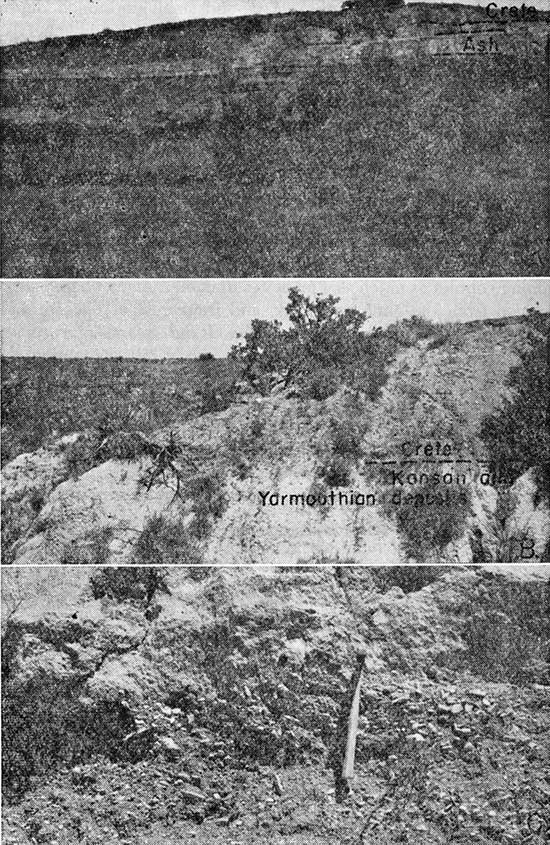
Plate 7--A, Pleistocene deposits overlying Carlile Shale in SE sec. 28, T. 14 S., R. 21 W. Several feet of sand and gravel of Crete Formation form top of deposit, beneath automobile. Light-colored wedge is volcanic ash in silt of Sappa Formation, which is separated from shale surface by a few feet of silt, sand, and gravel; B, Gravel of Crete Formation overlying Sappa silts in NE sec. 33, T. 14 S., R. 21 W.; C, Light-gray silts of Sappa Formation overlying gravel of Grand Island Formation in NE sec. 33, T. 14 S., R 21 W.
In this part of the Smoky Hill Valley these deposits represent channel fill of a single alluvial cycle and consist of gravel, sand, silt, and volcanic ash totaling about 50 feet in thickness. A test hole drilled at the SE cor. NE sec. 27, T. 14 S., R. 21 W., penetrated 54 feet of these deposits. The lower 25 feet, the Grand Island Formation, consists of sand and gravel, and the upper part, the Sappa Formation, of white fine-grained silt containing near the top several feet of impure, fresh-water silty limestone. In surface exposures the Grand Island is composed of sand and gravel containing cobbles as much as 4 inches in diameter, many chalk pebbles derived from the Niobrara chalk, and fragments of Carlile Shale. The Sappa conformably overlies the Grand Island and consists of 25 to 30 feet of stratified silt and sandy silt containing thin lenticular stringers of gravel or sand and lenses of volcanic ash (Pl. 7A) identified as the Pearlette Ash bed. The silt is buff or gray buff when fresh, weathers white, and in many places contains snail shells identified by A. B. Leonard (personal communication) as a typical Yarmouthian (Sappa) fauna. The following measured section is typical of the Grand Island and Sappa Formations:
| Measured section of Pleistocene deposits along north. bank of Smoky Hill River in NE sec. 33, T. 14 S., R. 21 W., Trego County. | Thickness, feet |
|||
|---|---|---|---|---|
| Neogene--Pleistocene | ||||
| 18. | Silt; contains some gravel; upper 1 foot in modern soil profile, lower 1 foot contains secondary limy material. To top of steep bluff | 2.8 | ||
| 17. | Silt, sandy, brown; contains clay; may be part of a soil profile | 4.1 | ||
| 16. | Silt, buff; contains sand and gravel in small lenses and some secondary limy material | 3.0 | ||
| Crete Formation | ||||
| 15. | Sand, silty, massive; contains gravel in lower part and snail shells throughout. Stands in vertical cliff | 3.0 | ||
| 14. | Gravel and sand, poorly stratified, brown; grades into underlying and overlying material | 3.6 | ||
| 13. | Gravel, medium to coarse, brown; contains many pebbles and cobbles in lower part, "clay balls" and fragments of concretions from Blue Hill Shale member; unconformable on Sappa member, but rests directly on Carlile Shale about half a mile southeast | 10.4 | ||
| Sappa Formation | ||||
| 12. | Silt, massive, buff; contains snail shells; upper 6 feet weathered yellowish buff | 3.5 | ||
| 11. | Silt, finely laminated, gray to light buff, weathers white; forms small bench | 3.7 | ||
| 10. | Sand, medium to coarse; contains very fine gravel; grades into overlying silt; lenticular, average thickness | .8 | ||
| 9. | Silt, massive, light buff, weathers white; contains snail shells; composed chiefly of chalk-derived material | 3.7 | ||
| 8. | Silt, massive, gray buff; contains thin lenticular bodies of gravel | 4.0 | ||
| 7. | Gravel, predominately waterworn chalk pebbles and fragments; lenticular, grades laterally into silt and clayey silt | 2.7 | ||
| 6. | Silt, well sorted, buff, weathers white; upper surface irregular and grades into bed 7 | 1.7 | ||
| 5. | Silt, poorly sorted, buff, and fine to medium sand; contains several thin lenses of gravel and pebbles | 3.8 | ||
| 4. | Silt, massive, buff, weathers white; contains very fine sand and trace of gravel; forms a small bench | 2.5 | ||
| Grand Island Formation | ||||
| 3. | Gravel; contains cobbles as much as 3 inches in diameter and many rounded chalk pebbles and shale fragments | 3.2 | ||
| 2. | Silt and very fine sand, massive, buff, weathers white; forms small ledge; lenticular, average thickness | .6 | ||
| 1. | Gravel; composed of cobbles as much as 4 inches in diameter, rounded chalk pebbles, fragments of Blue Hill Shale member, and medium to coarse sand; lower 3 feet covered to level of Smoky Hill River | 5.9 | ||
| Total measured section | 63.0 | |||
The Grand Island and Sappa channel fill is truncated at the top by an erosional surface that bevels the shale on each side of the channel. Sand and gravel of the Crete Formation (Pl. 7B) unconformably rests on this surface and makes up most of the gravel deposits beneath the prominent high terrace surface in Trego and Ellis Counties.
The Pearlette Ash bed has been identified in association with silt deposits that underlie the high terrace along Big Creek near Yocemento, 6 miles northwest of Hays. The high terrace farther downstream between Hays and Victoria may be composed, in part, of deposits of Kansan and Yarmouthian age. It has not, however, been practical to attempt to subdivide the Pleistocene deposits along Big Creek; therefore, on the geologic map (Pl. 1) they are mapped as Pleistocene deposits undifferentiated.
Water supply--In southeastern Trego County the Grand Island Formation is in contact with the alluvium, and the water table in the two formations is continuous (Pl. 2). Well 14-22-26ad at the Bureau of Reclamation construction office is the only well penetrating the Grand Island Formation in that area. Farther downstream, the ground-water body in the Grand Island extends into the overlying Crete Formation. Along Big Creek, the water table is continuous through the Nebraskan(?) deposits, Kansan deposits, Crete Formation, and alluvium.
Crete and Loveland Formations
General description--Bass (1926, p. 16) described the distinct high terrace, 80 to 120 feet above the stream, along Smoky Hill River. He noted that the terrace was composed of coarse gravel including chalk fragments and material derived from the Ogallala Formation. On the basis of local deposits of volcanic ash of Kansan and Yarmouthian age that are associated with fossiliferous silt and clay, Frye, Leonard, and Hibbard (1943) and later Frye, Swineford, and Leonard (1948) correlated the high terrace deposits along Smoky Hill River with deposits of Kansan age in McPherson County and elsewhere in Kansas. But as already stated, in Smoky Hill Valley these older deposits are restricted to a narrow channel. The prominent gravel deposits of wide extent beneath the high terrace along Smoky Hill River are assigned to the Crete Formation; these deposits are believed to be Illinoisan in age because they unconformably overlie the Kansan and Yarmouthian deposits, and they grade upward into sandy silt containing Loveland-type fossil snails (A. B. Leonard, personal communication).
The high terrace is the most prominent feature of the Smoky Hill Valley in this area. It is more than 2)f miles wide in eastern Trego County and western Ellis County, narrows to about 1 mile near Schoenchen where the resistant Greenhorn Limestone constricts the valley walls, and widens to about 2 miles in eastern Ellis County. In many places the terrace is scarcely dissected, and locally there are undrained depressions on it. Mapping of the upland margin of the terrace is difficult because deposits of loess and colluvium locally overlie the terrace. The terrace surface slopes from an altitude of 2,130 feet near the Cedar Bluff dam in Trego County to an altitude of about 1,840 feet in southeastern Ellis County near the Russell County line. This surface, which is called the Pfeifer Terrace, has a gradient of about 10 feet per mile in the western part of this area, but eastward from Schoenchen the gradient is only about 6 feet per mile, because the resistant Greenhorn Limestone hindered down cutting by the stream that deposited the terrace material.
The Crete and Loveland Formations underlying the high terrace have a maximum thickness of about 40 feet. The lower 15 to 20 feet, the Crete Formation, consists of coarse well-sorted sand and gravel, predominantly crystalline material that was redeposited from the Ogallala Formation. A few chalk pebbles were derived from the Niobrara Formation, but the percentage of chalk is much less than in the sand and gravel of the Grand Island Formation. In the basal part, the gravel contains many cobbles as much as 4 inches in diameter. The presence of fragments of shale from the Carlile Shale suggests rapid deposition by a swift-flowing stream before the shale could disintegrate. The coarse deposits are cross-bedded and lenticular, stained rusty brown by iron oxide, and grade upward into sand and silty sand. The sandy material grades upward into yellow and buff stratified silt (Loveland Formation) containing thin lenses of sand and gravel and scattered sand grains. Locally, small concretions of secondary calcium carbonate (Pl. 8B) and accumulation of clayey material indicate the ancient development of a soil profile in the silt. Description of a typical section of Pleistocene deposits underlying the Pfeifer Terrace accompanies that of the Grand Island and Sappa Formations. Locally, thin deposits of loess of the Peoria Formation overlie the Loveland or Crete deposits, but they have not been mapped separately on Plate 1.
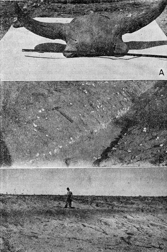
Plate 8--A, Fossil bison skull from terrace deposits at bottom of excavation for Cedar Bluff dam core trench; B, Caliche nodules in silt of Loveland Formation in road ditch in SE SW sec. 35, T. 14 S., R. 20 W.; C, Dark "bog" type paleosol developed in late Pleistocene silt in NE sec. 3, T. 15 S., R. 21 W.
Thin, discontinuous deposits of eolian silt and sandy silt of the Loveland Formation overlie bedrock or Nebraskan(?) deposits at many places in the upland area. These silts are generally friable and buff or reddish brown; locally they include the typical Sangamonian soil zone in their upper part. Because they are thin and discontinuous, these deposits in the upland areas were not separately mapped. In the following section, measured in a road cut along U. S. Highway 183 half a mile north of Smoky Hill River, silt of the Loveland Formation lies between silt of the Peoria Formation and sand and gravel of Nebraskan(?) age.
| Measured section of Upper Pleistocene and Nebraskan(?) deposits in SW NW sec. 27, T. 15 S., R. 18 W., Ellis County. | Thickness, feet |
|||
|---|---|---|---|---|
| Neogene--Pleistocene | ||||
| Peoria Formation | ||||
| 3. | Silt, gray buff; contains grains of sand and gravel and disseminated calcium carbonate; basal part in transition zone from soil below; upper 1.3 feet in modem soil profile. Thickens to north, minimum | 4.6 | ||
| Loveland Formation | ||||
| 2. | Silt, slightly sandy, noncalcareous, friable, reddish brown. Prominent soil zone in upper part | 3.7 | ||
| Nebraskan(?) deposits | ||||
| 1. | Sand and gravel; basal part contains much calcium carbonate and fragments of Ogallala Formation and Carlile Shale; upper 4 feet contains reel sandy silt anel caliche nodules; upper contact indistinct | 7.2 | ||
| Total measured Pleistocene section | 15.5 | |||
A large part of the deposits beneath the high terrace along Big Creek probably belongs to the Loveland and Crete Formations, but subdivision of those deposits was not feasible during this investigation.
Water supply--The Crete Formation is a principal source of ground water for domestic and stock supplies in the area of the Pfeifer Terrace in southern Ellis County and along the northern edge of Rush County where the depth to water ranges from 10 to 50 feet. In most of southeastern Trego County and locally in southwestern Ellis County, most of the Crete Formation lies above the water table. At other localities small lenses of sand and gravel in the silty Loveland Formation contain bodies of perched water (Fig. 14). In the western part of the area, the water table in the Crete Formation is not connected with the water table in the Grand Island Formation and the alluvium. At many places eastward from Schoenchen, however, the water table is continuous from the Crete deposits to the alluvium (Pl. 2), and the Hat surface of the Pfeifer Terrace may be an important recharge area.
Total dissolved solids in analyzed samples of water from wells penetrating the Crete Formation ranged from 332 to 1,180 parts per million. Because of the iron oxide present in the sand and gravel, the water contains more iron than that in the other Pleistocene rocks but not as much as the water from the Dakota Formation (Fig. 20, Table 8). The water is hard but is suitable for domestic and stock use.
Peoria Formation
Thin discontinuous patches of eolian silt of the Peoria Formation occur at many places in the uplands. These loess deposits generally are gray to gray buff, massive, and locally calcareous. In most places they are less than 5 feet thick, and at many places they are represented by only a few inches of silty material incorporated in the modern soil profile. In the western part of the area, deposits of Peoria have been reworked by slope processes and incorporated into the colluvium, or they have been deposited over colluvial material. Massive gray silt that locally overlies the buff stratified silt in the Pfeifer Terrace area may also be Peoria loess. Because it is thin and discontinuous, the Peoria was not differentiated on Plate 1.
The Brady soil has been tentatively identified as the soil zone (Pl. 8C) in the NE sec. 3, T. 15 S., R. 21 W., that is overlain by a few feet of gray friable silt, which may be the Bignell Formation. Similar deposits were noted elsewhere in the area.
Alluvium and Terrace Deposits
General description--Late Wisconsinan and Recent stream deposits along Smoky Hill River, Big Creek, and tributary valleys are mapped as alluvium and terrace deposits. The inner valley of Smoky Hill River, which is underlain by these deposits, is 1/4 to 3/4 mile wide, is cut about 50 feet below the level of the adjoining prominent Pfeifer Terrace, and in the western part of the report area is separated from the Pfeifer Terrace by a shale bluff. The alluvial material of the inner valley was deposited in two major alluvial cycles, one during late Wisconsinan time and the other in Recent time. The oldest part is the material of Wisconsinan age that fills a channel about 1/4 mile wide cut about 50 feet below the level of the present stream. The upper part is late Wisconsinan, but the basal part may be of early Wisconsinan age. This channel meanders in the same manner as the present river; at one place it will correspond to the modern channel but at another will be against one wall of the inner valley (Pl. 3). The deepest part of the channel can be located only by test drilling, because there is no surface indication of its position. Test drilling indicates that the Wisconsinan deposits are as much as 65 feet thick in some places. The lower 30 to 50 feet is coarse sand and gravel derived principally from the older Pleistocene rocks and the Ogallala Formation, and the upper 10 to 30 feet is soft friable gray silt or sandy silt. During excavation of the core trench for Cedar Bluff dam a bison skull (Pl. 8A) and cedar logs were found at the base of these terrace deposits overlying the Carlile Shale. Uneroded remnants of these deposits form a low terrace 30 to 60 feet below the Pfeifer Terrace and 15 to 20 feet above the level of the river (Pl. 4C). We named it the Schoenchen Terrace from the village of that name built on it. In Ellis and Trego Counties the late Wisconsinan deposits have been extensively eroded so that only small remnants of the Schoenchen Terrace remain along Smoky Hill River (Pl. 1), but we recognized remnants of this terrace as far west as Logan County.
Recent deposits underlie the Hood plain and channel of Smoky Hill River. These rocks consist of about 10 to 15 feet of sand, gravel, and silt that overlie shale of Cretaceous age or are channeled into late Wisconsinan deposits (Pl. 3).
Along Big Creek and its principal tributaries the inner valley is characterized by a well-developed terrace and a narrow Hood plain and channel. The terrace surface is 30 to 50 feet below the level of the broad high terrace along Big Creek and 20 to 25 feet above the level of the creek. The terrace is 1/2 to 1 mile wide along Big Creek and about 1/4 to 1/2 mile wide along North Fork Big Creek. The terrace deposits (mapped with the alluvium on pl. 1) are 30 to 50 feet thick, the lower 10 to 25 feet consisting of sand and gravel and the upper part of stratified silt and sandy silt. This terrace probably corresponds to the Schoenchen Terrace of the Smoky Hill Valley and to the late Wisconsinan terraces along Prairie Dog Creek and North Solomon River (Frye and Leonard, 1949; Leonard, 1952). The uppermost part of the terrace deposits is judged to be Recent in age because a wide area of the terrace surface in the vicinity of Hays was Hooded in the summer of 1951.
During Recent time, the terrace deposits were eroded to form the Hood plain and channel of Big Creek, and a thin layer of alluvial material was deposited over the eroded late Wisconsinan deposits. Recent deposits along Big Creek Valley are thin and of small lateral extent and have been mapped with the more widespread terrace deposits.
Water supply--In eastern Trego County and western Ellis County as much as 50 feet of terrace deposits filling the late Wisconsinan channel adjacent to Smoky Hill River is saturated. In the eastern part of Ellis County about 35 feet of material is saturated (Pl. 3). These deposits are the only aquifer capable of yielding large supplies of water to wells, and the city of Hays has five wells (15-18-27ca, 15-18-27cb1, 15-18-27cb2, 15-18-28da1, 15-18-28da2) penetrating them. In June 1949, well 15-18-27cb1 had a draw down of 26 feet when pumped at 844 gpm (gallons per minute) during a 48-hour pumping test, and well 15-18-28da2 had a drawdown of 24 feet when pumped at 860 gpm during a 24-hour pumping test. Although hard, the water is suitable for most purposes.
Moderate supplies of ground water are obtained from alluvial deposits of Big Creek valley and North Fork Big Creek valley. The thickness of saturated material and the permeability of these deposits are less than that in the Smoky Hill Valley and the yield of wells is much less. Hays formerly had 14 wells in the alluvium of Big Creek valley (Latta, 1948, fig. 3, table 1) that ranged in yield from 75 to 300 gpm and averaged about 140 gpm. The city of Victoria has five wells in the alluvium of North Fork Big Creek. The maximum yield of these wells reported by Latta (1948, table 4) was 70 gpm from a well in the NW sec. 18, T. 14 S., R. 16 W., and this well was reported to pump dry in 3 hours. The alluvial deposits, however, supply moderate amounts of water suitable for domestic and stock use.
Undifferentiated Pleistocene deposits
General description--Deposits classified as Pleistocene undifferentiated have been mapped (Pl. 1) in two areas: near Smoky Hill School in T. 15 S., R. 19 W., and in Big Creek valley eastward from Hays.
The deposits in the 4-square-mile area in T. 15 S., R. 19 W., underlie a relatively undissected terrace that borders an unnamed creek. The surficial material exposed in stream cuts is gray silt and sandy silt. The basal material is not exposed but is reported to be gravel. The deepest well inventoried in the area is 32 feet in depth and therefore the deposits are believed to have a maximum thickness of about 40 feet. The age of these deposits is unknown, but because the surface of the terrace is eroded only slightly, they must be relatively young. The terrace may correspond to either the Pfeifer or Schoenchen Terrace of the Smoky Hill Valley, and the deposits probably are Illinoisan or Wisconsinan in age.
The largest area of undifferentiated Pleistocene deposits shown on Plate 1 extends eastward from the vicinity of Hays. These deposits form a dissected "high terrace" adjacent to Big Creek valley, mostly north of the valley in the mapped area. The high terrace is about 5 miles wide at Hays but becomes nearly 7 miles wide near Victoria.
Test holes drilled into the high terrace along Big Creek penetrated 23 to 64 feet of Pleistocene deposits. The upper part consists of 15 to 55 feet of tan, brown, and buff calcareous silt and sandy silt that seems to be massive near the top but may be stratified in part. A large part of the silt probably belongs to the Loveland Formation, but the uppermost part may be loess of the Peoria Formation. Local deposits of light-colored silt associated with Pearlette volcanic ash are part of the Sappa Formation. The lower 6 to 30 feet of undifferentiated deposits consists of sand and gravel and locally contains thin stringers and layers of clay and silt. A few miles east of Ellis County the Big Creek high terrace is continuous with the high terrace of Smoky Hill River; therefore, most of the sand and gravel in the undifferentiated deposits probably is the Crete Formation. Exposures of sand and gravel north of Victoria have been identified tentatively as Nebraskan, and deposits known to be part of the Grand Island Formation have been noted elsewhere along Big Creek. The deposits beneath the Big Creek high terrace probably include stream deposits of Nebraskan to Sangamonian age and Wisconsinan loess.
Water supply--The undifferentiated deposits rest on a surface of erosion developed on Cretaceous bedrock. This surface is irregular but slopes generally southward toward Big Creek (Pl. 3). The water table in the deposits slopes toward Big Creek and North Fork Big Creek. The saturated thickness of these deposits ranges from a few feet to nearly 40 feet (Pl. 3), but is not generally greater than 10 feet. The depth to water ranges from 12 to 54 feet and averages about 32 feet (Pl. 2). Water from these deposits is hard, but is generally suitable for most uses.
Prev Page--Geography, Geology || Next Page--Geomorphology
Kansas Geological Survey, Geology
Placed on web Feb. 4, 2013; originally published March 1961.
Comments to webadmin@kgs.ku.edu
The URL for this page is http://www.kgs.ku.edu/Publications/Bulletins/149/04_form.html