| Original published in W.W. Hambleton, ed., 1959, Symposium on Geophysics in Kansas: Kansas Geological Survey, Bulletin 137, pp. 121-133 | ||
Exploration Surveys Inc
The complete article is available as an Acrobat PDF file.
This report includes a regional Bouguer gravity anomaly map of Kansas contoured on a 10-milligal interval, three gravity profiles and geologic cross sections, and a discussion of geologic structures that coincide with gravity anomalies. The data were compiled by Exploration Surveys Inc., Dallas, Texas. With few exceptions, control for compilation of the gravity map is excellent; only in the northeastern portion of the state is the control sparse. Known or suspected major structural elements that have good regional expression are discussed in relation to gravity anomalies; discussion of local detail is omitted.
We wish to thank the following contributors without whose help and advice compilation of the regional gravity map would have been impossible--Seaboard Oil Company, Dallas, Texas; Sunray-Mid-Continent Oil Company, Tulsa, Oklahoma; Ohio Oil Company, Tulsa, Oklahoma; and Paul L. Lyons, Sinclair Oil and Gas Corporation, Tulsa, Oklahoma. We also wish to thank Wallace Lee for helpful and constructive criticism.
The results obtained by detailed gravity work are a matter of record. Great strides have been made in instrumentation, interpretation, and field techniques during the last few years. In the past, gravity work has been subject to adverse criticism because of erroneous interpretations based on unreliable data collected many years ago with instruments lacking the refinement of modern instruments. In addition, certain areas present almost insurmountable problems for gravity study, and errors have arisen from attempts to extend gravity work into such areas. It is the purpose of this report to present an accurate regional gravity map of Kansas, which will aid in the interpretation of regional geology and dispel the criticism of skeptics as to the merits of gravity work in Kansas. It is appropriate to emphasize here that many of the geologic structures in Kansas are the product of several periods of deformation and that all structures are not of the same age nor is there expression of them in all of the rocks of the geologic column. Furthermore, some of these structures have expression in high density basement rocks and some do not. It is important to note also that changes in basement lithology may produce gravity anomalies that have no relation to structure. The paper includes discussion of major structures that coincide with gravity anomalies and omits discussion of local anomalies. This approach may be the practical means of bringing harmony to geological and geophysical concepts.
It is the intention of Exploration Surveys Inc. to incorporate this map with previously distributed regional gravity maps of Texas and Oklahoma and to release a revised map in the near future.
The regional Bouguer gravity anomaly map, contoured on a 10-milligal interval, is shown in Figure 1. Most of the map is based on accurate data and relatively close control. In places where data were lacking, especially in the extreme northeastern part of the state, it was necessary to rely upon pendulum stations for control. Certain liberties were taken in reducing data from various sources to a common base or to absolute values. At some places, interpretation is based on detailed gravity data not shown on the map. For purposes of discussion, numbers have been assigned to some of the well-known structural features that also are prominent gravity anomalies (Fig. 1).
Figure 1--Bouguer gravity anomaly map showing major geologic structures. Numbered structures are identified in text.
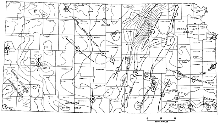
The most outstanding gravity anomaly on the map probably is the Abilene Anticline. This anomaly attains a maximum value of plus 10 milligals in Washington and Clay Counties. The axis of the anomaly extends almost south through the Voshell Anticline, into the eastern portion of Harper County, and on into Oklahoma, where it continues through a series of large maxima as far south as the Wichita Mountains. Detailed gravity data (not shown) also suggest strongly that the Abilene and Voshell Anticlines are parts of the same structure. It is interesting to note that the sediments east of the axis of the anticline differ greatly from those to the west, in that Cretaceous rocks in increasing thickness overlie Permian and Pennsylvanian rocks to the west and have been eroded from areas to the east.
In general, the gravimetric gradient in Kansas dips away from the Abilene Anticline in a westerly direction and gravimetric intensity attains its lowest values (approximately minus 110 milligals) on the western border of the state where the sedimentary cover is thick. East of the Abilene Anticline, the gradient has a predominantly eastward dip and, in the northeastern part of the state, intensity attains values of minus 60 milligals.
The Nemaha Anticline lies east of and nearly parallel to the Abilene Anticline. The trend of the Nemaha Anticline is well defined by detailed gravimetric mapping not shown on the regional map. It terminates to the north near Omaha, Nebraska, and extends southward through the eastern part of Sumner County and in the general direction of Oklahoma City, Oklahoma (Lee, 1956). Geologically, the Nemaha Anticline is a more dominant structural feature than the Abilene Anticline.
The Forest City Basin, which occupies the northeastern corner of Kansas (Fig. 1), is tilted gently toward the deep Brownville Syncline just east of the Nemaha Anticline. The basin limits have been defined in literature (Jewett, 1954, 1957; Lee, 1956). The regional gravity data indicate that it is bounded on the west by the Nemaha Anticline, on the south by the Bourbon Arch, and on the east by a series of gravity maxima, which probably have their origin in the Ozark Uplift. The large gravity minimum centering in Osage and Lyon Counties seems to be a subsidiary sedimentary basin of the Forest City Basin, and structural and stratigraphic evidence indicates that it is a part of the Forest City Basin. Very little exploration has been done in this section of Kansas and we believe that good possibilities exist for future oil production.
There has been some controversy as to the existence of the Bourbon Arch. Some writers contend that it is only a buried topographic feature. Others indicate that it is a low arch separating the Forest City and Cherokee Basins, as shown by thinning of a broad belt of pre-Kansas City Pennsylvanian rocks (Lee, 1943) and local thinning of Mississippian limestone over the arch in Bourbon County (Jewett, 1954). Both regional and detail gravity data indicate definitely that the Bourbon Arch does exist, inasmuch as there is a prominent maximum trend across Bourbon, Allen, Woodson, and Greenwood Counties.
The Cherokee Basin is shown on the gravity map as the area between the Bourbon Arch and the Chautauqua Arch (partly overlapping the Chautauqua Arch) that terminates at the Nemaha Anticline in Butler and Chase Counties. Although the limits of the Cherokee Basin are defined in the literature (Jewett, 1951), they are somewhat obscure on the regional gravity map. According to Lee, Leatherock, and Botinelly (1948), the Cherokee Basin syncline of post-Mississippian age trends north-south and cuts across the pre-Mississippian Chautauqua Arch, which trends east-west. Seemingly, the Chautauqua Arch was the dominant structural element and interrupted the younger Cherokee Basin in the Precambrian rocks, cutting it off from the southern extension of the Cherokee Basin in Oklahoma. Thus the gravity data may show the result of differing structural movements and may depict the aspect of the Cherokee Basin in Precambrian rocks.
Some geologists have indicated that the Cherokee Basin extends northward through Greenwood County and into Lyon and Osage Counties, but we believe that the Cherokee Basin is separate from the sedimentary basin shown by the gravity minimum in Osage and Lyon Counties. The Chautauqua Arch, in the southeastern corner of the state, is a prominent geological structure and gravimetric anomaly, even though it was modified by Cherokee Basin deformation.
The Sedgwick Basin occupies a position near the south end of the Voshell Anticline. The main gravimetric expressions are two well-defined minima of minus 50 milligals in Harper, Sumner, Sedgwick, and Harvey Counties. Seemingly, the Sedgwick Basin is part of the syncline between the Voshell and Nemaha Anticlines. Also, there is a strong possibility that the basin extends westward to the minimum in Kingman County.
The most prominent geologic feature west of the Abilene Anticline is the Central Kansas Uplift (or Barton Arch), from which has come a large part of the oil produced in Kansas. Gravimetrically, the Central Kansas Uplift is a broad maximum centering in Barton County. There is some indication of its continuation southward toward the Pratt Anticline and northwestward toward the Cambridge Arch.
Two well-developed minima of minus 50 milligals value, centering in Lincoln, Mitchell, and Osborne Counties, characterize the Salina Basin gravimetrically. The basin extended into Saline County in Pennsylvanian time. The Abilene Anticline is structurally within the Salina Basin.
The extreme western part of the state is occupied by the Hugoton Embayment of the Anadarko Basin, which closely follows the gravity grain. There is considerable argument about this feature and some writers extend it to include the Julesburg Basin of Colorado. We believe, from gravimetric evidence, that the maxima in Scott and Finney Counties define the northeastern limit of the Hugoton Embayment. The eastern limb of the Hugoton Embayment, the Northern Basin Shelf (Jewett, 1951) is characterized by a marked flattening in Meade; Clark, and Comanche Counties.
Other structures that are worthy of discussion as possible keys to future production are indicated by numbers on Figure 1. The names of most of these structures were taken from Jewett (1951).
The Brownville Syncline (1) is flanked on the west by the Nemaha Anticline and is the westernmost extremity of the Forest City Basin. Detailed gravity data show a well-defined minimum axis. Figure 1 shows flattening only. The Coffeyville Anticline (2) centers near the town of Coffeyville, in southeastern Montgomery County, and extends almost north. The axis of this structure is known to migrate to the west with depth. The gravity axis is prominent and shows a north-plunging nose on the Chautauqua Arch. The Conway Syncline (3) lies between the Central Kansas Uplift and the Voshell Anticline. The Conway Syncline is more evident on detailed gravity maps. The Ellsworth Arch or Anticline (4) lies in the central part of Ellsworth and Rice Counties, on the northeast flank of the Central Kansas Uplift. Its detailed gravity expression is an elongated positive or maximum axis superimposed on the broad gravity maximum shown on Figure 1. The Elbing Anticline (5) is located on the west flank of the Nemaha Anticline and its axis is parallel to the Nemaha Anticline. It is a distinct gravity anomaly on the detailed gravity map.
The El Dorado Anticline (6) is a prominent dome on the crest of the Nemaha Anticline. It is one of the most prominent local gravity anomalies along the entire Nemaha trend. There are several oil fields located on the dome; among these are some of the most prolific fields in Kansas. Gravity detail very accurately defines this structure. The Fairport-Notoma Anticline (7) is located on the northeast flank of the Central Kansas Uplift. Detailed gravity data show an asymmetrical positive anomaly nose, the steeper gradient being west of the axis. The Finney Basin or Shallow Water Basin (8) is located in Finney and Scott Counties. Gravimetrically, it is prominent and its structural axis corresponds closely with its gravimetric axis. This structure deserves additional investigation. The Fowler Syncline (9) modifies the southern end of the El Dorado Anticline. Although the regional gravity map shows no anomaly at this location, there is a conspicuous anomaly on a detailed gravity map.
The Halstead-Graber Anticline (10) is located at the northernmost extremity of the Sedgwick Basin, in McPherson and Harvey Counties, and at the southernmost extremity of the Irving Syncline. On the regional gravity map, it is shown as a weak maximum separating two gravity minima, which trend north-south. The Irving Syncline (11) occupies the area between the Nemaha Anticline and the Abilene Anticline. It is a prominent gravity minimum.
The Joplin Anticline (12) lies mainly in Missouri, where it is a very prominent gravity maximum, but it extends into Cherokee County, Kansas. The Keyes Dome (13) lies primarily in Cimarron and Texas Counties, Oklahoma. Its northern flank extends through southern Morton County, Kansas, into Baca County, Colorado. It is a prominent gravimetric feature and is closely defined by local detail. The Kraft-Prusa structure (14), an elongate anticline, is located gravimetrically on the highest portion of the Central Kansas Uplift. The Lincoln Syncline (15) is a distinct gravimetric feature, terminating against the Elbing Anticline. It is a structural depression on the crest of the Nemaha Anticline. The Longton Ridge (16) is a subsurface feature that has no particular surface expression but is prominent on local detailed gravity maps. It extends from northeastern Chautauqua County through the southeastern corner of Elk County into Wilson County. The Miami Trough (17) is suggested on the regional gravity map and is very prominent on local detailed gravimetric maps. This is a north-trending synclinal feature on the north flank of the Chautauqua Arch. The Morris Anticline (18) is a pronounced gravimetric feature in eastern Wyandotte and Johnson Counties, which also can be seen in outcropping rocks of Missourian Age. The Mound City Dome (19) is a positive gravity anomaly in eastern Linn County, similar in character to the Morris Anticline. Both features extend into Missouri.
The Pratt Anticline (20) is a southward continuation of the Central Kansas Uplift in Stafford, Pratt, and Barber Counties. It is shown by nosing of the gravity contours. The Cambridge Arch (21) is a broad structural feature, north of the Central Kansas Uplift, in parts of Decatur, Norton, and Phillips Counties, which extends into Nebraska. Its location is shown on the regional gravity map by a broad maximum, but the exact location of its axis is a matter of conjecture. The Otto-Dexter-Beaumont Anticline (22) is a series of structures and corresponding gravity anomalies, which we identify here as a unit because we expect it to be important for future oil production. It is probably the outstanding structure east of the Nemaha Anticline, in an area within the Cherokee Basin. The Willow Creek Anticline (23) centers in northern Greeley County and extends into southern Wallace County. It is the northwestern terminus of a large regional gravity maximum that trends northwest across Finney, Scott, Wichita, and Greeley Counties. This gravity maximum possibly may be an expression of structure that has its roots in the Las Animas Arch. We feel that this general area deserves considerable future attention. The Otis Arch (24) is a very prominent gravimetric feature on the southwestern flank of the Central Kansas Uplift or Barton Arch. Its eastern extremity terminates at approximately the Otis Gas Field. It trends northwest across Barton, Rush, Ellis, and Trego Counties.
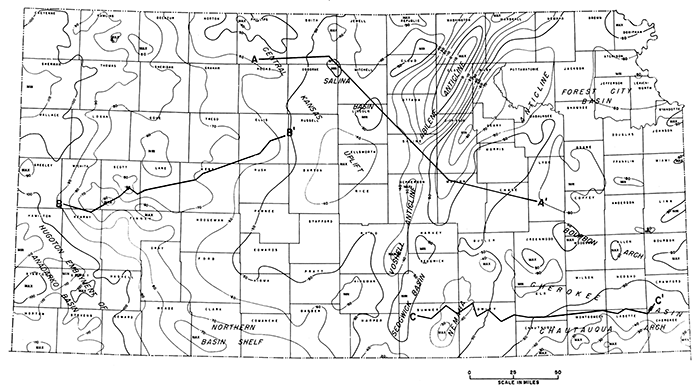
Three gravity profiles and accompanying geologic cross sections (locations shown on Fig. 2) are included in this report in order to show more clearly the relationship between regional geologic structures and regional gravity anomalies.
Figure 2--Map showing location of Bouguer gravity anomaly profiles.
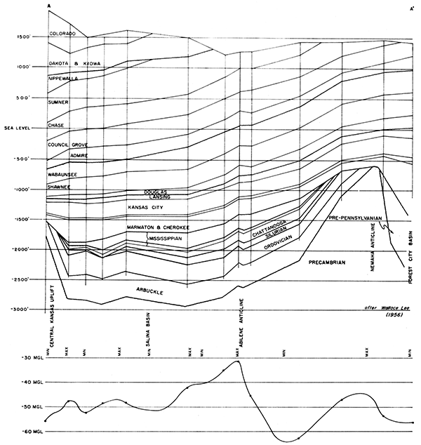
Section AA' (Fig. 3), from Phillips County to Lyon County, crosses the Central Kansas Uplift, the Salina Basin, the Abilene Anticline, the Nemaha Anticline, and a part of the Forest City Basin. The geologic section, from Lee (1956), shows coincidence of gravity anomalies and geologic structures in most places. If the amplitude of a gravity anomaly is a function of depth of basement granite, however, gravimetric values are unusually low across the Central Kansas Uplift and the Nemaha Anticline as compared with the Abilene Anticline. This condition has been attributed to incomplete isostatic adjustment or unknown density contrasts in the basement rocks. Detailed gravity data show local, sharp anomalies, which can be related to proximity of basement rocks; these anomalies offer no particular interpretation problems.
Figure 3--Cross section and gravity profile AA' from Phillips County to Lyon County.
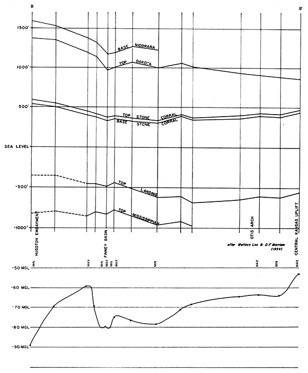
Section BB' (Fig. 4), from Wichita County to Ellis County, begins at the Hugoton Embayment, crosses the Finney Basin and the Otis Arch, and ends at the Central Kansas Uplift. The geologic section is taken from Lee and Merriam (1954).
Figure 4--Cross section and gravity profile BB' from Wichita County to Ellis County.
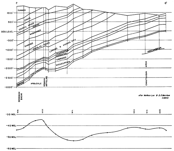
Section CC' (Fig. 5), from Sumner County to Crawford County, begins at the Sedgwick Basin, crosses the Nemaha Anticline and the Cherokee Basin, and ends on the flank of the Chautauqua Arch. The geologic section is taken from Lee and Merriam (1954a). Both of these sections show good agreement between gravity and structural data.
Figure 5--Cross section and gravity profile CC' from Sumner County to Crawford County.
Although faults are not shown on the cross sections or gravity profiles, either on or flanking the Nemaha, Voshell, and Abilene Anticlines, we find strong evidence of faulting from detailed gravity data.
Kansas is an old oil producing state, but future possibilities are not exhausted, and gravimetric data seemingly can be an excellent guide for future exploration.
Gravity work indicates that the Otto-Dexter-Beaumont area, between the east flank of the Nemaha Anticline and the Cherokee Basin, offers promise for future exploration. The Arbuckle Group has been little tested in this area and merits attention. In addition, the southern extension of the Forest City Basin, centering particularly in Osage and Lyon Counties, offers excellent exploration possibilities.
We believe that the Salina Basin, in Lincoln and Osborne Counties, should not be overlooked. It offers a thick sedimentary section and is located on the flank of the Central Kansas Uplift.
The Hugoton Embayment should not be ignored in future exploration, which should be concentrated along the axis of the large regional gravity maximum extending from the northeast corner of Finney County to the northwest corner of Greeley County. Thinning of the sedimentary section against the Central Kansas Uplift enhances the production potential.
Jewett, J. M. (1951) Geologic Structures in Kansas: Kansas Geol. Survey, Bull. 90, pt. 6, p. 105-172. [available online]
Jewett, J. M. (1954) Oil and Gas in Eastern Kansas: Kansas Geol. Survey, Bull. 104, p. 1-397.
Lee, Wallace (1943) The Stratigraphy and Structural Development of the Forest City Basin in Kansas: Kansas Geol. Survey, Bull. 51, p. 1-140. [available online]
Lee, Wallace (1956) Stratigraphy and Structural Development of the Salina Basin Area: Kansas Geol. Survey, Bull. 121, p. 1-167. [available online]
Lee, W., Leatherock, C., and Botinelly, T. (1948) The Stratigraphy and Structural Development of the Salina Basin: Kansas Geol. Survey, Bull. 74, p. 1-148. [available online]
Lee, Wallace, and Merriam, D. F. (1954) Preliminary Study of the Structure of Western Kansas: Kansas Geol. Survey, Oil and Gas Invest. 11, p. 1-73, pl. 1-6. [available online]
Lee, Wallace, and Merriam, D. F. (1954a) Cross Sections in Eastern Kansas: Kansas Geol. Survey, Oil and Gas Invest. 12, p. 1-8, pl. 1-4. [available online]
Kansas Geological Survey
Comments to webadmin@kgs.ku.edu
Web version Nov. 22, 2013. Original publication date 1959.
URL=http://www.kgs.ku.edu/Publications/Bulletins/137/Jopling/index.html