![]()
Prev Page--Introduction || Next Page--Core and Sample Descriptions
Stratigraphy
By Daniel F. Merriam
Only a brief description of Mesozoic rocks encountered by the drill in northwestern Kansas is presented here. For further discussions on stratigraphy the reader is referred to Moore and others (1951, 1952), and Prescott (1953); for structure, reference is given to Jewett (1951), and Lee and Merriam (1954).
Inasmuch as the Dakota Formation on the surface in Kansas has not been certainly correlated in detail with the subsurface units identified in the Denver Basin, informal subsurface terminology will be used in this report. This terminology has not been accepted officially by the State Geological; Survey and thus is used only as a matter of convenience of classification here. Merriam (1957) has suggested possible correlations of surface and subsurface units, although much additional work, especially on surface outcrops, is necessary before correlations can be verified. The main difference is in the use of Dakota, which is used to designate a formation on the surface (Plummer and Romary, 1947), whereas in the subsurface approximately the same unit is here designated by the name Omadi. [Note: The names Omadi Formation and Dakota Group, as used in this report, are capitalized as formal names, although they have not been formally accepted by the State Geological Survey of Kansas. They are not to be regarded as informal names in the sense that "Algal limestone" or "Bartlesville sand" is an informal name.] In this report, then Dakota is tentatively used to include the Omadi, Kiowa, and Cheyenne formations.
Rocks overlying the Dakota Group have been traced into the subsurface from outcrops, and no difficulties arise in identifying these units, even where concealed. Most units, especially Cretaceous beds, can be traced into the neighboring states of Colorado and Nebraska. Indeed, type sections of some of the Cretaceous beds (for example Niobrara Formation, Carlile Shale, Greenhorn Limestone, and Graneros Shale) are in adjacent states, and these rocks have been traced and their nomenclature extended into Kansas.
Post-Dakota Rock Units
Quaternary
Rocks of Quaternary age occur as a thin veneer over western Kansas. They consist, for the most part, of unconsolidated gravel, sand, and silt, which occur as alluvial deposits in present stream valleys and as a loess mantle on upland surfaces. An excellent summary of Pleistocene deposits of the state may be found in Frye and Leonard (1952).
Tertiary
The Ogallala Formation, mainly Pliocene in age, unconformably underlies Quaternary deposits in northwestern Kansas. The Ogallala is composed of loosely cemented gravel, sand, silt, and volcanic ash. A reference marker bed, the "Algal limestone", occurs at the top of the formation. In Cheyenne County the Ogallala reaches a maximum thickness of about 300 feet in the southwestern part (Merriam, 1955a). Further information on beds of this age can be obtained from Frye, Leonard, and Swineford (1956).
Cretaceous
Cretaceous deposits in the state are composed mainly of shale, chalk, limestone, and sandstone. Most of the sediments were deposited under marine conditions, as is evident from the abundance of marine invertebrate and vertebrate fossils. Many thin beds of bentonite are intercalated throughout the post-Dakota strata. All post-Dakota units are Upper Cretaceous (Gulfian) in age and belong to either the Montana or Colorado Groups. The cross section (Fig. 1) shows position of Cretaceous formations relative to each other as well as to underlying formations in Cheyenne County.
Figure 1—Electric-log sections showing stratigraphic relations of Mesozoic rock units in Cheyenne County, Kansas.
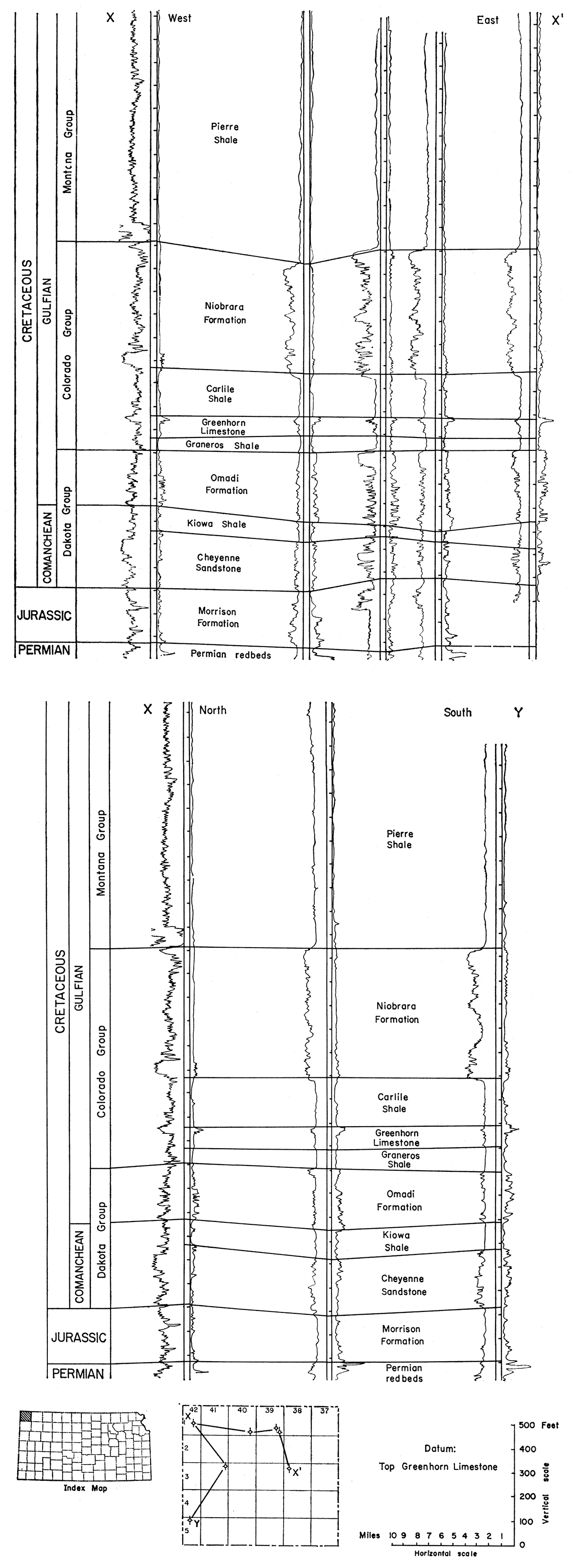
Pierre Shale is the uppermost Cretaceous formation present in Kansas. On the surface it has been divided into six units (Elias, 1931) only one of which, the Sharon Springs Shale member, is identifiable with certainty in the subsurface. The formation, part of the Montana Group, is mainly shale containing many concretionary zones. The shale, is light to dark gray, soft, micaceous, fissile, slightly calcareous, and fossiliferous. In Cheyenne County the maximum thickness of the f.or.mation is about 1,600 feet in the extreme northwestern corner. The beveled Pierre is unconformably overlain by Tertiary and Quaternary deposits.
The Niobrara Formation, uppermost unit of the Colorado Group, conformably underlies Pierre Shale. The Niobrara has been subdivided into the Smoky Hill Chalk (upper) and Fort Hays Chalk (lower) members. Both of these units are traceable in the subsurface. The Smoky Hill is chiefly a chalky (or calcareous) shale, light, medium, or dark gray, mottled, soft, calcareous, and fossiliferous. Thin stringers of bentonite are common. The Fort Hays is a white or light-gray, chalky, porous, soft, fossiliferous limestone containing interbedded soft chalky shale. Maximum thickness of the Niobrara Formation in Cheyenne County is about 600 feet.
The Carlile Shale conformably underlies the Niobrara Formation. This unit, which contains three identifiable members, consists predominantly of shale but contains some sandstone. The Codell, upper member of this unit, is a brown to gray, fine- to medium-grained, subangular sandstone containing interspersed silt. The middle member is the Blue Hill, which is composed of gray to blue-gray clayey noncalcareous shale. The Fairport, a chalky shale, is the lowermost member of the Carlile. It contains stringers of limestone. Thin layers of bentonite are present near the base of the member. The Carlile is fossiliferous; it has a nearly uniform thickness of about 200 feet.
Conformably underlying Carlile Shale is the Greenhorn Limestone. On the surface the formation is divisible into four members, but no effort has been made to identify these units in the subsurface. The Greenhorn consists chiefly of limestone and limy shale (Bergman, 1949). The limestone is gray to light brown, chalky or crystalline, and fossiliferous; shale is gray to brownish; calcareous, and fossiliferous. A persistent bed in the uppermost part of the formation is known as the Fencepost Limestone. This bed produces an easily identifiable double-pronged kick on electric logs and may be traced over a large area in the Midcontinent and Rocky Mountain regions. In Kansas the Greenhorn unit has a uniform thickness of about 100 feet.
The Graneros Shale is the lowest unit of the Colorado Group and conformably underlies Greenhorn Limestone (Plummer and Romary, 1942). This formation is composed of shale but contains minor amounts of sandstone and thin stringers of bentonite. The Graneros is a medium-gray to black, noncalcareous or slightly calcareous silty shale. Locally it is abundantly fossiliferous. One bentonite bed, termed the "Bentonite marker bed", is traceable over large areas and serves to subdivide the formation. It is blue-gray bentonite, 1 to 2 feet thick in Kansas, and causes an easily identifiable kick on electric logs. In Cheyenne County, thickness of the formation ranges from about 50 to 100 feet. Graneros Shale overlies the Dakota Group disconformably over much of western Kansas.
Dakota Group
The Dakota Group as tentatively defined here includes that sequence of rock strata of Cretaceous age between overlying Graneros Shale and underlying rocks ranging in age from Permian to Jurassic. In the subsurface as on the surface the group is divisible into three formations, but in the subsurface, especially in the northwestern part of the state, units of the group are more consistent and more easily recognized, and lend themselves to lithologic subdivision more readily than on the outcrop. An area of scanty information, which causes untold difficulties in correlation of different units, occurs near the outcrop, where the rocks are covered but so shallow as not to be adequately logged.
Uppermost unit of the group is termed the Omadi Formation (see Condra and Reed, 1943; Boreing, 1953; and Merriam, 1957, for stratigraphic nomenclature pertaining to this formation and its present status in Kansas); middle unit, Kiowa Shale; and lower unit, Cheyenne Sandstone. In turn, the Omadi Formation is subdivided into three members: Gurley Sandstone (upper), Huntsman Shale, and Cruise Sandstone (lower). Sands of the Dakota Group in the Denver Basin have been given letter designations as a matter of practicability. The "D", "G", and "J" sands are in the Omadi Formation; the "M", "O", "R", and "T" sands in the Cheyenne Sandstone. Preliminary investigations indicate that sands also occur at approximately the same stratigraphic positions in Kansas and thus they could and have been referred to by the same letter terminology.
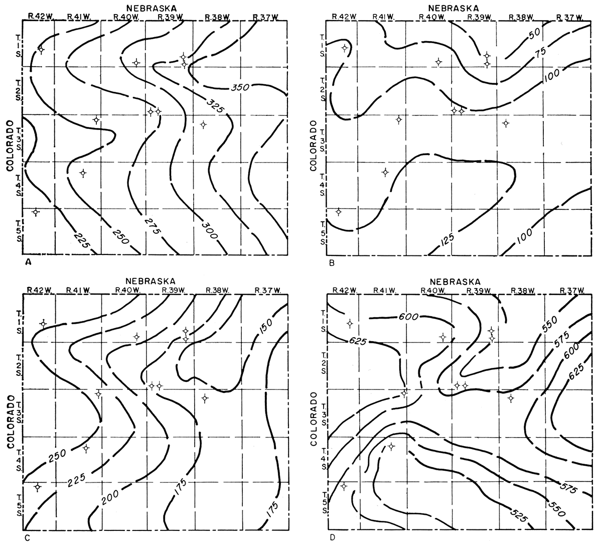
Figure 2D shows the thickness of the Dakota Group, which ranges from about 525 feet in south-central Cheyenne County io about 625 feet in the east-central and west-central parts of the county. Generally, the thickness is variable because of the unconformity at the base of the group.
Figure 2—Isopachous maps of formations in Dakota Group in Cheyenne County, Kansas. A. Thickness of Omadi Formation. B. Thickness of Kiowa Shale. C. Thickness of Cheyenne Sandstone. D. Total thickness of Dakota Group.
Omadi Formation is judged to be Upper Cretaceous (Gulfian), whereas Kiowa Shale and Cheyenne Sandstone are believed to be Lower Cretaceous (Comanchean) by the Kansas Geological Survey (Moore and others, 1951).
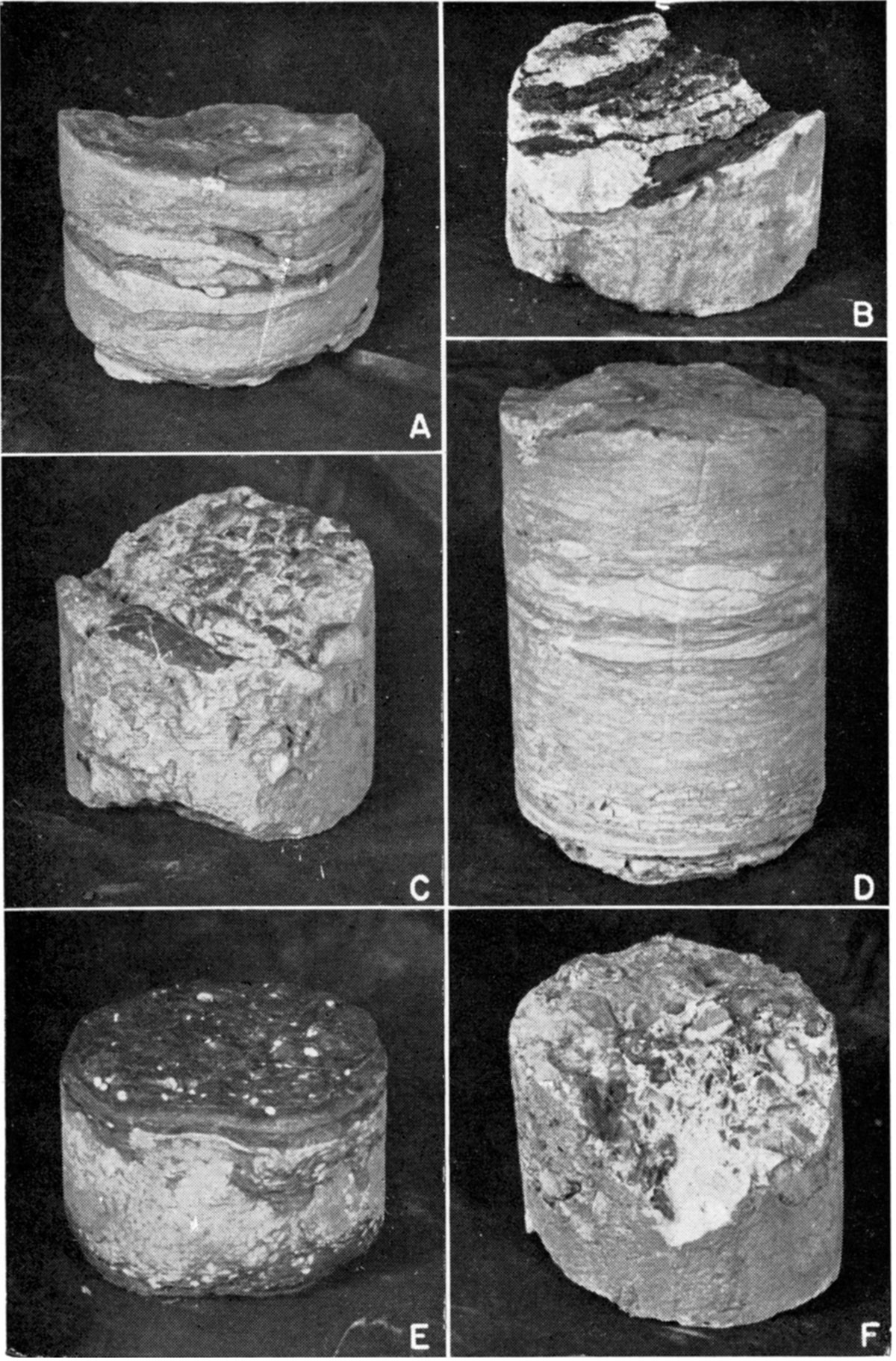
Many interesting sedimentary structures and rock types were observed in the core. Some of the sedimentary structures closely resemble those pictured by Fentress (1955, p. 181). Plate 1A shows distorted bedding in an alternating sequence of sand and shale of the Gurley member. Large fragments of carbonaceous material are pictured in Plate 1B. Carbonaceous material is common throughout the Omadi Formation, although that pictured is from the Huntsman member. Plate 1C and 1F show conglomeratic sandstone from the Cruise member; the pebbles, which are composed mainly of collophane, are rounded and polished. Plate 1D and 1E exhibit the intricate nature of erratic bedding of interbedded sandstone and shale of two samples from the Cruise member. Small rounded masses of white fine-grained sand are observable in the black laminated shale on the upper surface of the core sample on Plate 1E. These "sandballs" are common in parts of the Omadi Formation.
Plate 1—Photographs of representative core samples from Guy F. Atkinson No. 1 Beaumeister well. Diameter of core, 3 inches. A. Distorted bedding in alternating sequence of sandstone and shale of Gurley member. B. Large fragments of carbonaceous material from Huntsman member. C. Conglomeratic sandstone of Cruise member. D. Sandstone lenses in laminated shale of Cruise member. E. Distorted shale laminae in sandstone of Cruise member. F. Conglomeratic sandstone containing bone(?) fragments, Cruise member.
Recent articles on the Denver Basin include the excellent symposium published by the Rocky Mountain Association of Geologists (1954), McCoy (1953), Boreing (1953), Fentress (1955), Finley, Dobbin, and Richardson (1955), and MacQuown and Millikan (1955).
Omadi Formation
The Omadi Formation consists of sandstone, siltstone, conglomerate, shale, and clay. One thin bed of coal is present. Thickness of the formation increases eastward in Cheyenne County (Fig. 2A) to a maximum of about 350 feet. Contacts of the Omadi with adjacent overlying and underlying units are conformable or locally unconformable (Merriam, 1957).
Gurley Sandstone member—The Gurley consists mainly of sandstone but includes some shale and siltstone. In general, sandstones are light to medium gray, fine to coarse grained, slightly micaceous, calcareous, and friable. Shales are medium gray, noncalcareous, and thinly laminated. Siltstones are light gray, micaceous, and noncalcareous, and some are carbonaceous. Shaly streaks are common in both sandstones and siltstones, and sandy streaks are present in the shales.
In Cheyenne County, thickness of the Gurley ranges from about 60 to 100 feet. The member, in general, thins to the east and from preliminary correlations seems not to crop out in Kansas but to be truncated and overstepped by Graneros Shale, which rests on the Huntsman Shale member in the subsurface near the outcrop (Merriam, 1957, pl. 1).
Huntsman Shale member—The Huntsman Shale is composed of shale and sandstone. The shale is medium to dark gray, noncalcareous, clayey or sandy, and contains carbonaceous material. Sandstones are light gray, fine to medium grained, noncalcareous to slightly calcareous, shaly, and carbonaceous.
The Huntsman is the thinnest member of the Omadi; in Cheyenne County its thickness ranges from 10 to 25 feet. Preliminary correlations suggest that this member may correlate with the outcropping Janssen Clay (Merriam, 1957).
Cruise Sandstone member—The Cruise is mainly sandstone, siltstone, and shale, but contains minor amounts of clay, conglomerate, and coal. Sandstones are typically light brown or gray, fine to medium grained, calcareous, and friable; siltstones are light gray, micaceous, carbonaceous, shaly, and hard; and shales are medium gray, noncalcareous, and soft. The clay is light gray to greenish gray and silty, and locally contains siderite "pellets". The conglomerates are composed of rounded, smooth, black pebbles. The coal is lignitic.
The Cruise Sandstone in Cheyenne County ranges in thickness from about 130 to 220 feet. This unit may correspond to the exposed Terra Cotta Clay (Merriam, 1957).
Kiowa Shale
Kiowa Shale consists of shale, some siltstone and sandstone, and minor amounts of limestone. The shale is medium to dark gray, noncalcareous, slightly micaceous and pyritic, soft, and fossiliferous. The siltstone is light gray, slightly calcareous and micaceous, and hard. Sandstones are gray, very fine to fine grained, and slightly calcareous, micaceous, and glauconitic. A thin bed of impure hard limestone occurs near the base of the formation. The Kiowa has not been subdivided in the subsurface.
Thickness of the Kiowa Shale in Cheyenne County ranges from 50 to 125 feet (Fig. 2B). In other parts of the state it attains a, maximum thickness of approximately 150 feet. Detailed descriptions of the formation on the outcrop are given by Latta (1946).
Cheyenne Sandstone
Cheyenne Sandstone has no recognized named subdivisions in the subsurface, although several could be made. The formation is composed of sandstone but contains socie shale and other minor constituents. Sandstones are light gray or brown, fine to medium grained, glauconitic, micaceous, pyritic, and noncalcareous; shales are medium to dark gray, noncalcareous, and soft. A very thin bed of coal containing amber was found just below the Kiowa-Cheyenne contact.
Thickness of the formation in Cheyenne County (Fig. 2C) ranges from 150 to 250 feet and in general decreases to the east and south. Latta (1946) gives a detailed description of the formation on the outcrop in south-central Kansas.
Pre-Dakota Rock Units
In Cheyenne County, the Cretaceous Dakota Group is underlain by the Jurassic Morrison Formation (Merriam, 1955). These Jurassic deposits attain a thickness of 350 feet in northwestern Kansas and thin toward the east, southeast, and south to a featheredge. They do not crop out in the state. Where the Morrison Formation is not present, the Cretaceous is underlain by rocks of Permian age, mainly redbeds. In extreme southwestern Kansas the Cretaceous rests on the Triassic Dockum (?) Group. The Mesozoic rock sequence as a whole unconformably overlies the Permian, indicating a hiatus of considerable length in the state.
Prev Page--Introduction || Next Page--Core and Sample Descriptions
Kansas Geological Survey, Geology
Placed on web July 27, 2017; originally published April 15, 1959.
Comments to webadmin@kgs.ku.edu
The URL for this page is http://www.kgs.ku.edu/Publications/Bulletins/134_1/03_strat.html