![]()
Prev Page--Stratigraphy || Next Page--Analyses
Core and Sample Descriptions
By Daniel F. Merriam and William R. Atkinson
Although no electric log or radioactivity log was available for the Guy F. Atkinson No. 1 Beaumeister well, other data such as a drillers log, sample log, and drilling-time log were available. The drillers log, which was supplied by the Kansas Geological Society's Well Log Bureau, is brief (Table 2). No tops were given on the log; furthermore, because of the brevity of the log, no tops could be picked. The anhydrite encountered at a depth of 2,880 feet is too shallow to be the Stone Corral (Cimarron anhydrite of subsurface terminology) but possibly is the Blaine.
Table 2—Drillers log of Guy F. Atkinson No. 1 Beaumeister (SE SE NE sec. 31, T. 2 S., R. 39 W.). Elevation, 3,266 feet RB; total depth, 3,010 feet. H & H Drilling Company, contractor. Casing: 8 5/8 in. at 194 feet, cemented with 150 sacks of cement. Production, dry.
| Lithology | Depth to bottom of formation, feet. |
|---|---|
| Shale and sand | 194 |
| Shale | 1,370 |
| Shale and sand | 1,930 |
| Shale | 1,997 |
| Coring | 2,484 |
| Shale | 2,495 |
| Shale and sand | 2,717 |
| Shale and lime | 2,800 |
| Coring | 2,827 |
| Shale and lime | 2,863 |
| Shale | 2,880 |
| Anhydrite | 2,913 |
| Shale and sand | 3,010 |
| Total Depth | |
The original sample log prepared by James D. Bishop, Chief Geologist of the Guy F. Atkinson Company, is presented in Table 3 in slightly abbreviated form. From this detailed log it is possible to ascertain the following tops: Pierre Shale, 10 feet; Niobrara Formation, 1,130 feet; Fort Hays Chalk member, 1,620 feet; Carlile Shale, 1,650 feet; Blue Hill Shale member, 1,710 feet; Fairport Shale member, 1,820 feet; Greenhorn Limestone, 1,890 feet; Graneros Shale (estimated), 1,975 feet; Omadi Formation, 2,034 feet; Kiowa Shale, 2,308 feet; Cheyenne Sandstone, 2,419 1/2 feet; Morrison Formation, 2,590 feet; Permian redbeds, 2,895 feet; and the total depth of the well at 3,010 feet, still in Permian redbeds. The Stone Corral was not reached. Lithologically the rock units encountered in this well are similar to their respective units in other parts of northwestern Kansas and thus are easily recognized.
Table 3—Sample log of Guy F. Atkinson Company No. 1 Beaumeister well, examined by James D. Bishop, Chief Geologist, Guy F. Atkinson Company.
| Depth | Description of material | |
|---|---|---|
| From | To | |
| 0 | 5 | Silty sandy loam |
| 5 | 10 | Medium to coarse-grained sand |
| 10 | 40 | Yellow, gray to dark-gray, weathered shale |
| 40 | 260 | Gray, slightly calcareous, fissile shale |
| 260 | 520 | Gray to dark-gray, fissile, calcareous shale |
| 520 | 610 | Dark-gray to black, fissile, noncalcareous shale |
| 610 | 630 | Ditto with white bentonite |
| 630 | 670 | Dark-gray to black, fissile, noncalcareous shale |
| 670 | 850 | Ditto; fossil shells and limy concretions |
| 850 | 1030 | Dark-gray to black, noncalcareous shale, some bentonite, fossil fragments, and limy concretions |
| 1030 | 1130 | Brown to dark-gray, slightly calcareous, fossiliferous shale |
| 1130 | 1200 | Brown to gray, very calcareous, slightly fossiliferous shale; some bentonite |
| 1200 | 1570 | Gray speckled white, calcareous, slightly fossiliferous shale; some bentonite |
| 1570 | 1590 | Gray to white, slightly shaly chalk |
| 1590 | 1620 | Gray speckled white, slightly shaly, fossiliferous chalk; some bentonite |
| 1620 | 1650 | White, limy chalk |
| 1650 | 1710 | Gray, fine- to medium-grained, calcareous sand |
| 1710 | 1730 | Gray, chalky shale |
| 1730 | 1820 | Ditto; some bentonite |
| 1820 | 1870 | Ditto; some white, crystalline limestone |
| 1870 | 1890 | Gray to dark-gray, chalky shale |
| 1890 | 1930 | Gray, medium hard, dense to finely crystalline limestone |
| 1930, | 1997 | Dark-gray, very calcareous fossiliferous shale |
| 1997 | 2021 | Gray to dark-gray, calcareous, fossiliferous, fissile shale; thin bentonite beds |
| 2021 | 2034 | Dark-gray to black, noncalcareous, fossiliferous, fissile shale |
| 2034 | 2484 | Core of Dakota Group (see detailed log, Figure 3) |
| 2484 | 2505 | Gray to dark-gray, hard, fissile shale; some coarse-grained quartz sandstone |
| 2505 | 2540 | Gray, medium-grained, calcareous sandstone |
| 2540 | 2550 | Gray to dark-gray shale |
| 2550 | 2560 | Gray, hard, pyritic, calcareous sandstone |
| 2560 | 2585 | Gray to dark-gray shale and medium-grained, well-cemented sandstone |
| 2585 | 2590 | Gray, coarse-grained, quartz sandstone |
| 2590 | 2680 | Green and gray, bentonitic shale |
| 2680 | 2755 | Green to gray, bentonitic shale and white to buff, medium-hard, crystalline limestone and dolomite |
| 2755 | 2775 | Green and gray, bentonitic, sandy shale; some white, dense, medium-hard limestone |
| 2775 | 2795 | White to buff, dense, slightly sandy limestone and green and gray, sandy, bentonitic shale |
| 2795 | 2805 | White to buff, dense, finely crystalline, sandy cherty limestone |
| 2805 | 2860 | Gray to green, medium-hard, calcareous shale; stringers of crystalline, cherty limestone |
| 2860 | 2885 | Red-brown sandstone |
| 2885 | 2915 | White gypsum and anhydrite; some medium crystalline limestone and red and gray shale |
| 2915 | 2925 | Green and gray, sandy shale |
| 2925 | 3010 | Brick-red shale, gray sandy shale, and some red to gray medium-grained sandstone |
| 3010 | Total depth | |
A gas odor was noted by Bishop at the top of the Niobrara Formation in a zone that possibly is faulted. Stratigraphically this is the same zone that produced minor amounts of gas in Sherman County in the old Goodland field. Also, under fluorescent light some dark-golden-brown oil stains were noted in the Omadi Formation. A few zones in the Omadi beds showed traces of free oil, but when the core was studied several months later, no traces of oil were found.
The drilling-time log is presented in Table 4. Time intervals are 10-foot to a depth of 1,997 feet and then 1-foot to total depth. Pertinent information concerning drilling operations is noted in the remarks column.
Table 4—Drilling-time log of Guy F. Atkinson Company No. 1 Beaumeister well, SE SE NE sec. 31, T. 2 S., R. 39 W., Cheyenne County, Kansas.
| All measurements from rotary bushing, 5 feet above ground elevation of 3,262 ft.; size of hole, 7 7/8 in.; drill pipe: 4 1/2 in. | |||
| Depth | Drilling time, minutes | Remarks | |
|---|---|---|---|
| From | To | ||
| (10-foot time) | |||
| 200 | 300 | 4-4-3-3-3-3-3-3-3-3 | Date 4-29-1955; started drilling from under surface pipe at 7:43 p.m. |
| 300 | 400 | 3-3-3-3-4-4-3-3-3-3 | |
| 400 | 500 | 4-3-4-3-3-3-3-6-5-6 | |
| 500 | 600 | 2-3-2-3-2-3-3-2-2-3 | Test slope @ 594 ft.; (1;2%) |
| 600 | 700 | 3-3-3-4-3-4-3-3-3-3 | Date 4-30-1955 |
| 700 | 800 | 3-3-2-2-3-3-4-3-3-3 | |
| 800 | 900 | 3-2-2-3-3-3-3-4-5-5 | |
| 900 | 1000 | 4-5-4-4-4-3-4-4-5-4 | |
| 1000 | 1100 | 4-4-4-4-5-5-5-4-5-5 | Test slope @ 1061 ft.; (1%) |
| 1100 | 1200 | 4-4-3-3-3-3-3-4-3-3 | |
| 1200 | 1300 | 2-3-2-3-3-3-3-3-3-3 | |
| 1300 | 1400 | 3-3-4-5-7-7-6-3-3-3 | |
| 1400 | 1500 | 2-2-2-3-3-3-2-3-2-2 | Jetted pits |
| 1500 | 1600 | 3-4-4-3-3-3-3-2-3-2 | Test slope @ 1590 ft.; (%%) |
| 1600 | 1700 | 3-3-4-5-5-3-2-3-4-5 | |
| 1700 | 1800 | 5-7-9-9-10-10-11-11-11-11 | |
| 1800 | 1900 | 10-9-9-9-10-10-10-12-12-12 | |
| 1900 | 1997 | 10-10-10-11-10-11-10-10-11-10 | Cir. 45 min. @ 1997 ft.; (Trip) |
| (1-foot time) | |||
| 1997 | 2000 | 27-24-33 | Start core 1 @ 1997 ft.; |
| 2000 | 2010 | 28-35-21-21-20-18-19-19-18-18 | Vis. 38, wt. 9.2 5-1-1955 |
| 2010 | 2020 | 16-13-14-16-18-20-17-15-16-12 | |
| 2020 | 2030 | 17-17-15-18-11-12-26-16-14-15 | Pulled core for inspection @ 2026 ft.; |
| 2030 | 2040 | 13-15-16-12-8-11-3-2-1-1 | (core loss 4 ft. 7 in.) Start core 2 |
| 2040 | 2050 | 2-3-7-6-5-5-5-7-7-7 | |
| 2050 | 2060 | 8-10-7-6-6-7-6-5-5-4 | |
| All measurements from rotary bushing, 5 feet above ground elevation of 3,262 ft.; size of hole, 7 7/8 in.; drill pipe: 4 1/2 in. | |||
| Depth | Drilling time, minutes | Remarks | |
|---|---|---|---|
| From | To | ||
| 2060 | 2070 | 6-6-6-9-7-12-13-18-15-14 | End of core 2 @ 2076 ft.; start core 3. |
| 2070 | 2080 | 17-17-17-14-17-7-10-3-1-2 | Vis. 35, wt. 9.1 5-2-1955 |
| 2080 | 2090 | 2-3-2-1-2-2-2-2-2-3 | Pump press. 350 |
| 2090 | 2100 | 2-2-2-1-2-2-2-2-2-2 | |
| 2100 | 2110 | 3-2-2-3-2-1-3-4-4-4 | |
| 2110 | 2120 | 3-4-1-2-3-5-5-7-10-6 | |
| 2120 | 2130 | 9-8-6-5-2-8-6-1-4-7 | End of core 3 @ 2126 ft.; start core 4 |
| 2130 | 2140 | 6-5-1-3-4-4-6-2-2-4 | |
| 2140 | 2150 | 1-1-1-3-13-10-2-4-8-7 | Vis. 41, wt. 9.1, pump press. 450 |
| 2150 | 2160 | 4-5-5-6-6-6-4-6-4-5 | |
| 2160 | 2170 | 5-4-4-5-5-7-7-5-5-4 | |
| 2170 | 2180 | 5-4-5-6-6-7-9-6-4-4 | End of core 4 @ 2176 ft.; start core 5 |
| 2180 | 2190 | 6-3-3-5-5-6-6-5-7-8 | 5-3-1955 |
| 2190 | 2200 | 8-8-14-11-15-2-2-2-3-2 | |
| 2200 | 2210 | 2-9-6-5-9-9-12-11-12-9 | Vis. 42, wt. 9.2 |
| 2210 | 2220 | 6-4-5-7-8-8-8-8-5-5 | |
| 2220 | 2230 | 6-7-6-6-7-5-6-7-9-12 | End of core 5 @ 2226 ft.; start core 6 |
| 2230 | 2240 | 11-8-5-9-4-4-3-5-2-2 | Vis. 38, wt. 9.1, pump press. 450 |
| 2240 | 2250 | 5-6-4-4-7-5-5-6-6-7 | |
| 2250 | 2260 | 7-6-7-6-7-5-3-2-3-5 | Vis. 41, wt. 9.2, pump press. 350 |
| 2260 | 2270 | 3-4-4-4-3-3-2-3-3-3 | End of core 6 @ 2276 ft.; start core 7 |
| 2270 | 2280 | 4-5-2-2-2-2-2-2-2-2 | |
| 2280 | 2290 | 1-2-2-2-2-2-1-2-2-2 | 5-4-1955 Pump press. 350 |
| 2290 | 2300 | 2-2-2-1-2-1-2-2-2-2 | |
| 2300 | 2310 | 2-2-2-3-2-5-3-6-12-8 | End of core 7 @ 2309.5 ft.; start core 8 |
| 2310 | 2320 | 30-30-25-22-14-10-7-10-21-27 | 5-5-1955 |
| 2320 | 2330 | 26-23-24-23-22-20-20-22-17-23 | Vis. 44, wt. 8.9, pump press. 450 |
| 2330 | 2340 | 23-24-20-23-21-14-15-16-14-14 | 5-6-1955 |
| 2340 | 2350 | 19-19-16-10-9-9-7-9-8-9 | |
| 2350 | 2360 | 13-12-13-13-16-20-17-14-9-3 | End of core 8 @ 2359 ft.; start core 9 |
| 2360 | 2370 | 4-6-10-7-11-12-6-4-3-14 | 5-7-1955 Vis. 39, wt. 9.1 |
| 2370 | 2380 | 16-12-12-16-19-16-16-17-19-20 | |
| 2380 | 2390 | 18-17-12-15-10-13-17-19-16-17 | Vis. 37, wt. 8.9 |
| 2390 | 2400 | 10-17-17-15-10-5-6-12-11-8 | |
| 2400 | 2410 | 15-8-5-10-13-15-15-14-16-21 | End of core 9 @ 2409 ft.; start core 10 |
| 2410 | 2420 | 14-17-15-12-7-8-8-11-12-9 | 5-8-1955 |
| 2420 | 2430 | 3-3-2-2-4-4-6-6-3-5 | Pulled core 10 @ 2427 ft. (damaged diamond corehead—pyrite) |
| 2430 | 2440 | 5-4-3-4-7-10-8-3-4-3 | |
| 2440 | 2450 | 2-2-5-7-5-4-6-11-14-2 | |
| 2450 | 2460 | 4-6-5-6-8-5-2-1-2-2 | End of core 11 @ 2454 ft.; start core 12 |
| 2460 | 2470 | 2-3-3-2-3-1-2-3-4-2 | |
| 2470 | 2480 | 5-4-6-4-8-8-11-13-14-12 | End of core 12 @ 2484 ft. (stopped coring) |
| 2480 | 2490 | 13-16-11-9-2-3-2-3-2-3 | |
| 2490 | 2500 | 3-3-3-3-4-3-2-3-4-2 | 5-9-1955 (5-ft. samples) |
| 2500 | 2510 | 1-2-2-1-2-1-2-3-2-2 | Vis. 40, wt. 9.0 |
| 2510 | 2520 | 2-1-2-1-2-2-1-1-1-2 | |
| 2520 | 2530 | 1-1-1-1-3-2-2-2-2-2 | |
| 2530 | 2540 | 2-2-1-2-2-3-3-2-2-2 | |
| 2540 | 2550 | 2-3-2-2-3-2-1-1-3-2 | |
| 2550 | 2560 | 2-4-7-1-5-5-5-4-8-7 | Slope test (1%) |
| 2560 | 2570 | 5-4-4-4-1-1-4-3-3-1 | |
| 2570 | 2580 | 1-1-1-1-1-1-1-1-1-2 | |
| 2580 | 2590 | 1-2-4-2-3-3-3-3-3-2 | |
| All measurements from rotary bushing, 5 feet above ground elevation of 3,262 ft.; size of hole, 7 7/8 in.; drill pipe: 4 1/5 in. | |||
| Depth | Drilling time, minutes | Remarks | |
|---|---|---|---|
| From | To | ||
| 2590 | 2600 | 2-4-5-3-5-5-3-1-1-1 | Vis. 39, wt. 9.0 |
| 2600 | 2610 | 1-1-1-1/2-1-1-1-1-1-1 | |
| 2610 | 2620 | 1-3-5-6-4-5-5-5-3-5 | |
| 2620 | 2630 | 4-3-3-4-5-3-5-5-4-5 | |
| 2630 | 2640 | 5-6-4-5-4-2-2-1-5-4 | Vis. 38, wt. 9.1 |
| 2640 | 2650 | 4-3-1-1-3-1-2-1-2-1 | |
| 2650 | 2660 | 1-2-2-1-6-6-6-1-1-1/2 | |
| 2660 | 2670 | 1/2-1/2-1/2-1/2-1/2-1-1-3-5-2 | |
| 2670 | 2680 | 2-1-3-4-2-2-3-2-7-* | * 1 foot kelly correction |
| 2680 | 2690 | 12-8-7-8-8-11-10-9-13-14 | Vis. 36, wt. 9.3 |
| 2690 | 2700 | 12-11-11-11-11-15-24-12-25-17 | Trip @ 2700 ft. (new bit) |
| 2700 | 2710 | 2-4-5-2-3-5-6-4-5-5 | |
| 2710 | 2720 | 7-9-5-5-3-2-3-4-4-4 | |
| 2720 | 2730 | 3-3-4-5-3-4-2-3-2-3 | |
| 2730 | 2740 | 2-2-3-3-3-1-2-5-3-3 | |
| 2740 | 2750 | 3-5-4-3-2-3-2-2-2-3 | |
| 2750 | 2760 | 3-2-2-2-2-2-1-3-2-3 | |
| 2760 | 2770 | 2-2-2-2-1-2-3-2-3-2 | |
| 2770 | 2780 | 2-3-2-4-2-2-4-2-3-2 | Circ. 1 hr. @ 2775 ft. |
| 2780 | 2790 | 2-2-2-2-2-3-2-3-2-3 | Circ. % hr. @ 2790 ft. |
| 2790 | 2800 | 2-2-2-2-3-3-2-3-4-2 | Circ. 1 hr. @ 2800 ft. |
| 2800 | 2810 | 11-8-12-10-8-11-9-11-9-11 | 5-10-1955 Start core 13 @ 2800 ft. |
| 2810 | 2820 | 10-10-17-12-10-9-8-12-14-14 | Vis. 38, wt. 9.2 |
| 2820 | 2830 | 15-15-12-13-13-14-12-2-2-2 | End of core 13 @ 2827 ft. |
| 2830 | 2840 | 4-4-2-3-3-3-3-2-3-3 | |
| 2840 | 2850 | 3-3-4-4-4-4-4-2-2-4 | |
| 2850 | 2860 | 4-3-5-5-4-4-2-5-6-4 | |
| 2860 | 2870 | 3-2-3-3-4-3-2-2-3-2 | |
| 2870 | 2880 | 1-2-2-2-2-3-3-2-2-7 | |
| 2880 | 2890 | 8-7-6-2-2-8-7-7-2-3 | |
| 2890 | 2900 | 2-1-2-6-7-5-9-9-8-10 | |
| 2900 | 2910 | 8-8-8-8-7-7-8-7-7-7 | |
| 2910 | 3920 | 7-6-6-4-4-4-3-3-3-3 | |
| 2920 | 2930 | 3-3-2-2-2-2-4-2-3-3 | |
| 2930 | 2940 | 2-3-2-3-3-2-3-3-4-2 | |
| 2940 | 2950 | 2-2-3-2-3-3-4-3-3-7 | |
| 2950 | 2960 | 8-7-5-4-1-1-1-1-1-1 | |
| 2960 | 2970 | 1/2-1/2-1-1/2-1/2-1-1/2-1/2-1/2-1/2 | |
| 2970 | 2980 | 1/2-1/2-1-1-1/2-1/2-1/2-1/2-1-1/2 | |
| 2980 | 2990 | 1/2-1/2-1/2-1/2-1-1/2-1/2-1-1-1/2 | |
| 2990 | 3000 | 1-1-1-1-1/2-1/2-1-1-1-1 | |
| 3000 | 3010 | 1-1-1-1/2-1/2-1-1/2-1/2-1-1 | T.D. 5-10-1955 11:00 p.m. |
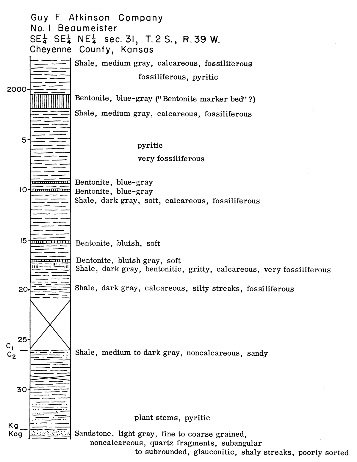
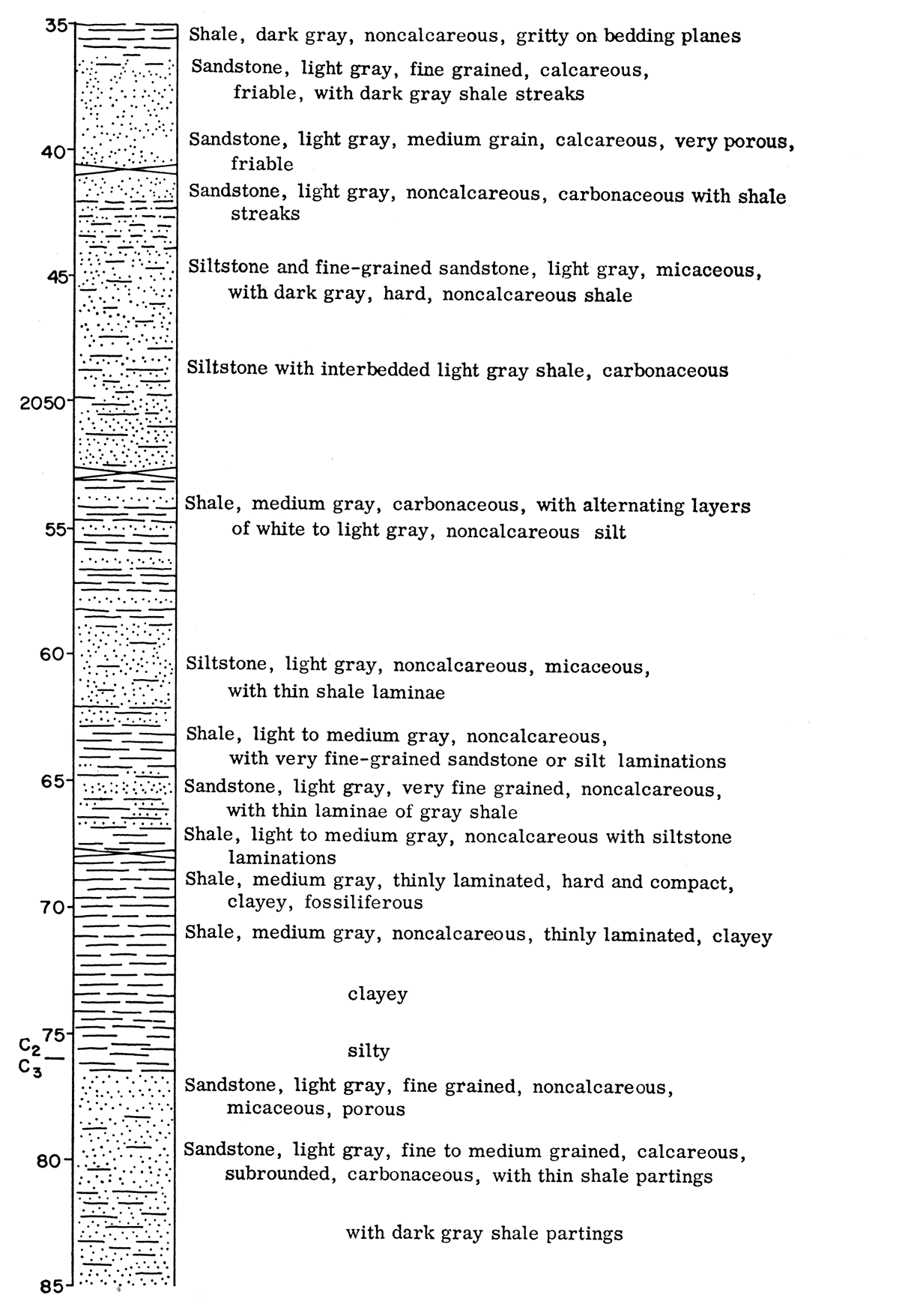
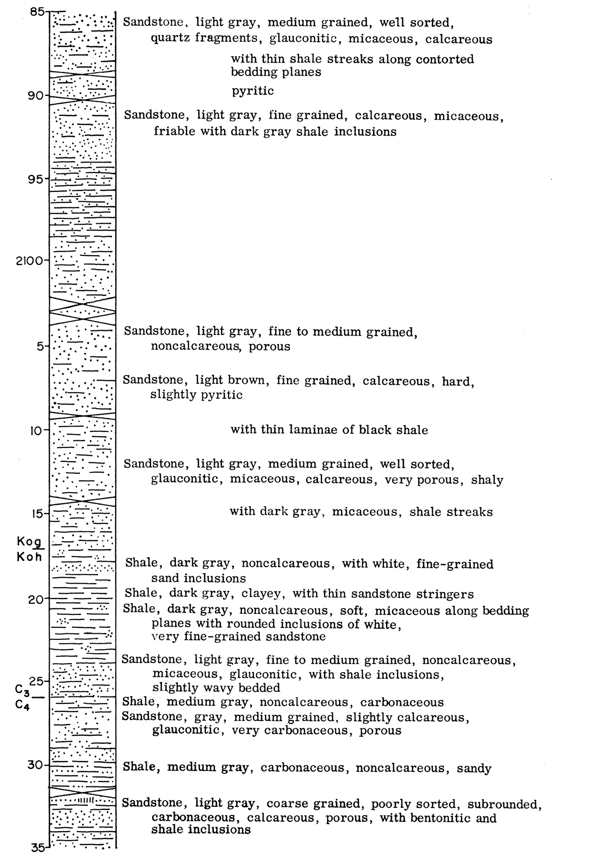
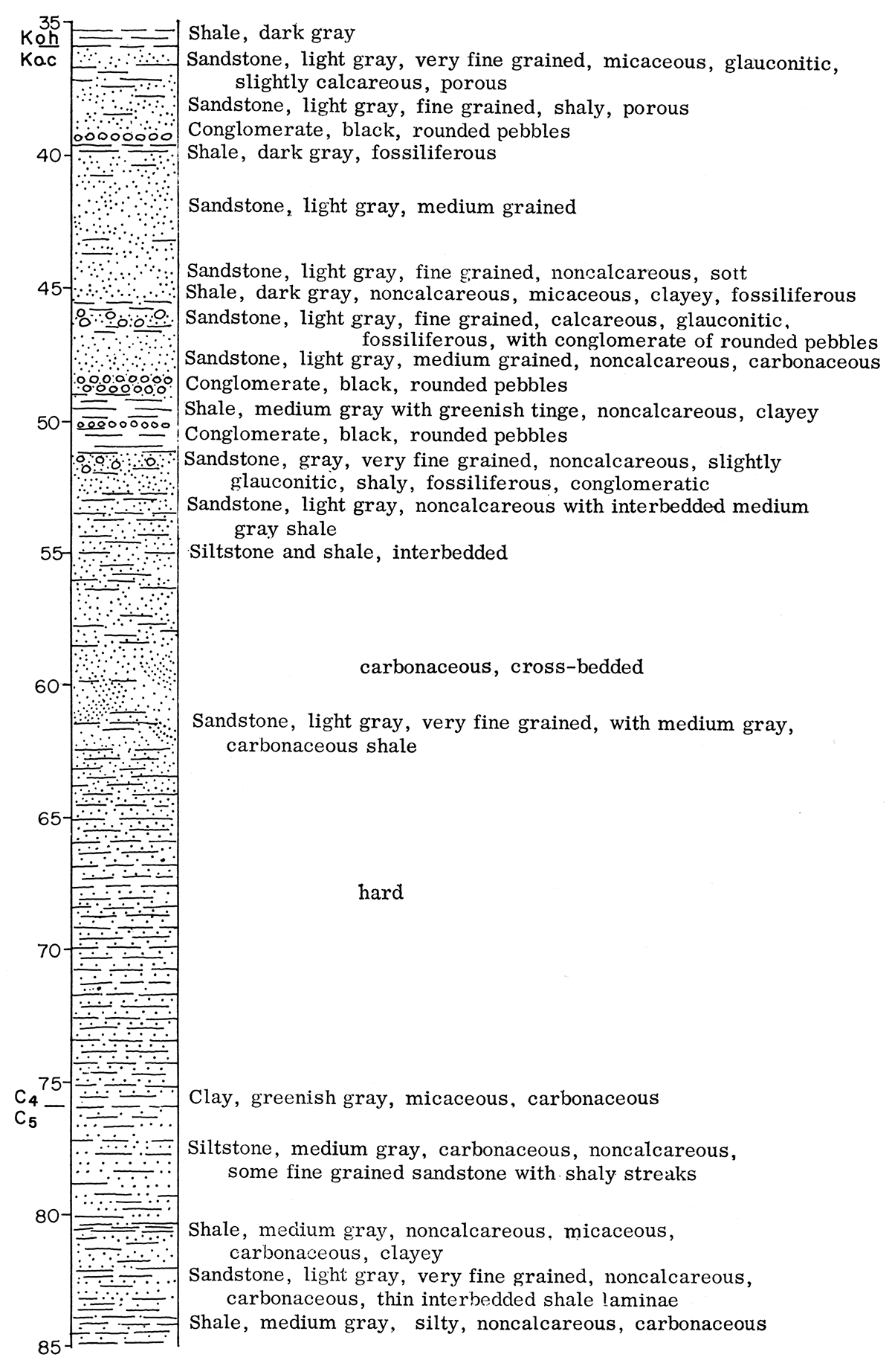
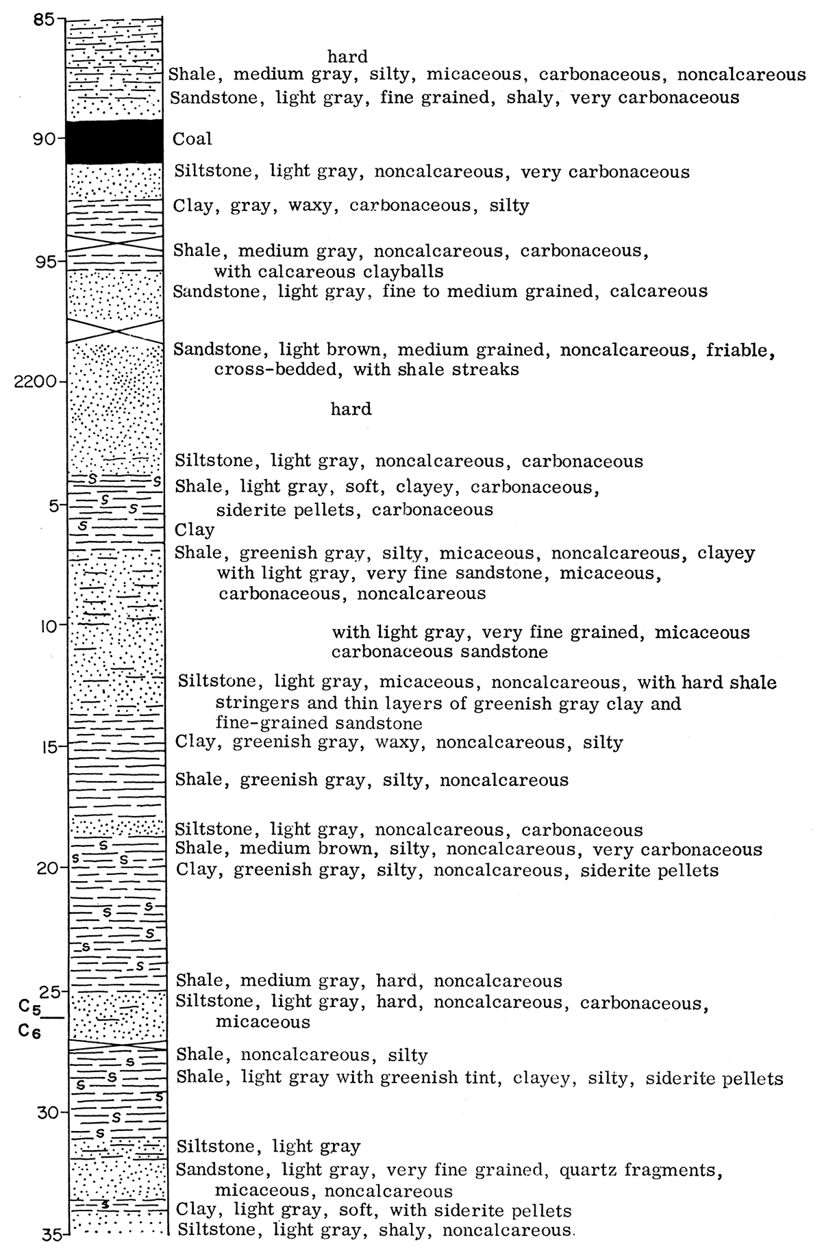
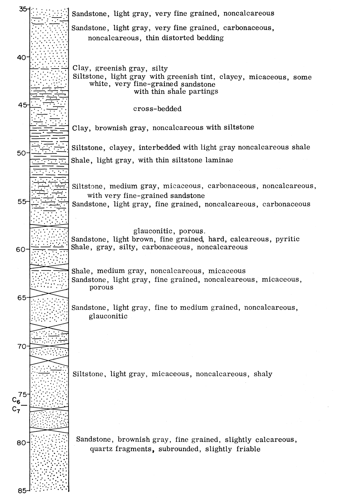
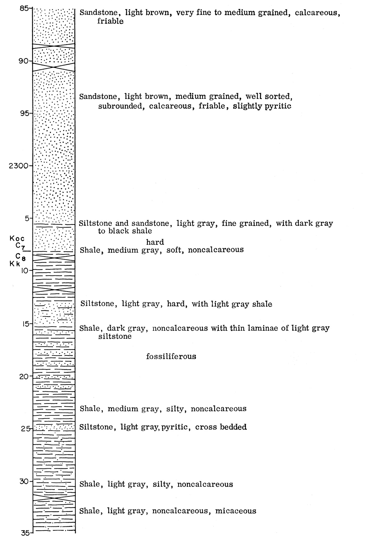
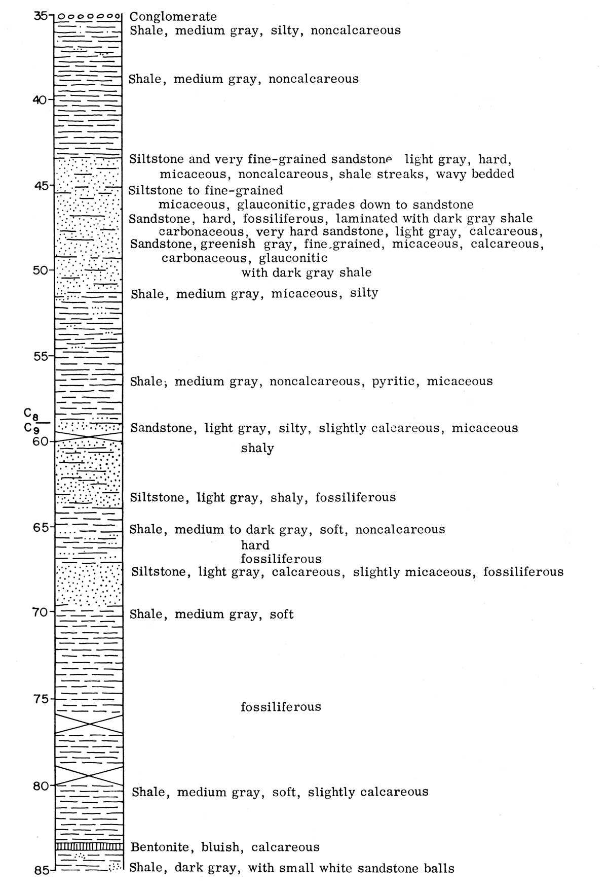
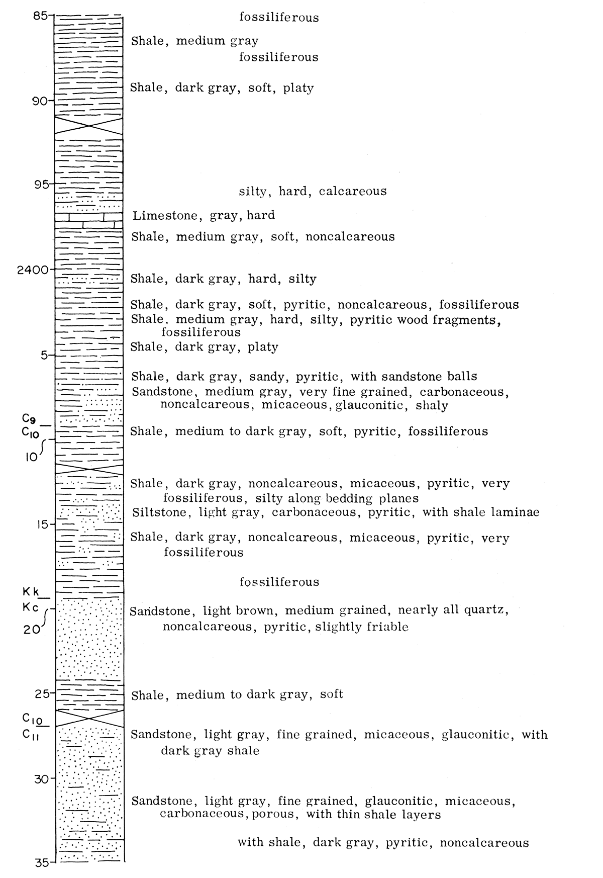
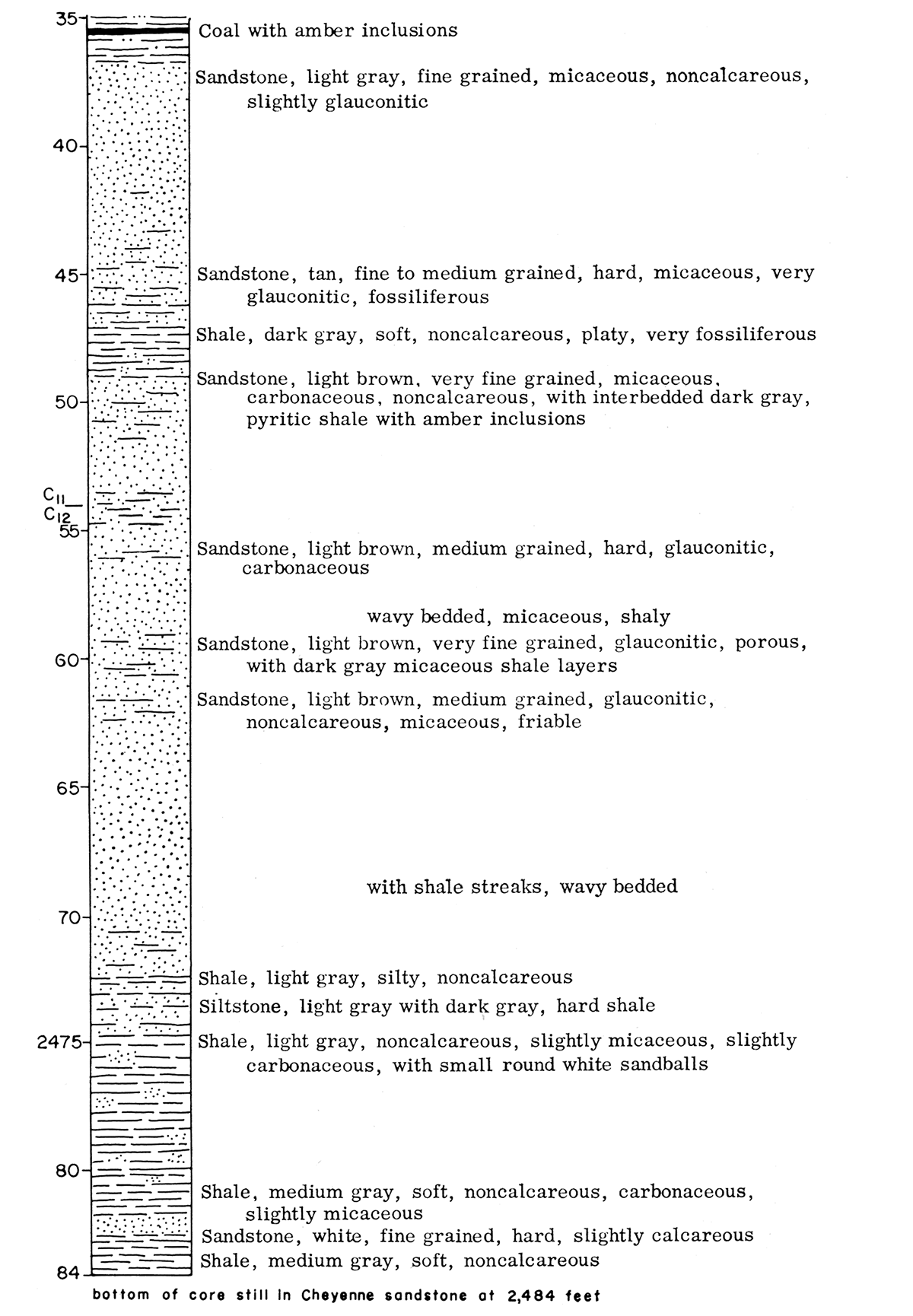
Lithology of the Cretaceous Dakota core is shown in graphic form in Figure 3. Descriptions are supplemented by binocular and petrographic spot descriptions.
Figure 3—Graphic description of Dakota (Cretaceous) core from Guy F. Atkinson No. 1 Beaumeister well.
Paleontology
Megafossils
The following is a summary by William A. Cobban of the megafossils he identified from the core (written communication, July 6, 1956).
"The fossils from the cores of the Guy F. Atkinson No. 1 Beaumeister well in sec. 31, T. 2 S., R. 39 W., are all marine species. The presence of Inoceramus and "Corbula" in much of the core suggests moderately shallow water. The brachiopod Lingula occurs in marine and brackish-water deposits, but the associated fossils in the Kiowa cores show it to be marine there. The few fossils from the Omadi Formation, although indicating a marine environment, cannot be used for correlation."
Table 5 includes identification of fossils, their depth, and remarks made by Cobban.
Table 5—Description of megafossils from the Guy F. Atkinson No. 1 Beaumeister well.
| Depth | |
|---|---|
| Fossils from Graneros Shale | |
| 1998 1/2 | Medium-dark-gray calcareous shale. Foraminifera: Pelagic species Pelecypods: Inoceramus prefragilis Stephenson; Ostrea sp. Remarks: The Inoceramus was described from the Woodbine Formation of Texas by Stephenson (U.S. Geol. Survey Prof. Paper 242, p. 64). I believe Stephenson's species is identical with Inoceramus pictus Sowerby from the Upper Cenomanian of England. |
| 2007 | Medium-dark-gray noncalcareous shale. Pelecypod: Inoceramus arvanus Stephenson Remarks: Another Woodbine species (U. S. Geol. Survey Prof. Paper 242, p. 65). Inoceramus is strictly a marine form. |
| 2011 | Medium-dark-gray calcareous shale. Pelecypod: Inoceramus arvanus Stephenson Cephalopod: Fragment of an ammonite, possibly Euomphaloceras |
| 2011 1/2 | Medium-dark-gray slightly calcareous shale. Pelecypod: Inoceramus arvanus Stephenson Vertebrate: Fragment of fish jaw |
| Fossils from Omadi Formation | |
| 2145 1/2 | Light-gray fine-grained argillaceous sandstone containing black-coated, brown phosphatic (?) pebbles. Brachiopod: Lingula n. sp. Remarks: The presence of this brachiopod suggests either a brackish-water or near-shore marine environment. |
| 2246 | Light-gray very fine grained sandstone. Pelecypod: Laternula n. sp. Remarks: A marine form. |
| 2285 | Medium-dark-gray noncalcareous shale. Pelecypod: Inoceramus sp. Remarks: A marine environment is indicated by the presence of this genus. |
| Fossils from Kiowa Shale | |
| 2317 1/2 | Gray siltstone with dark shale partings. Brachiopod: Discinoid species |
| 2363 | Gray siltstone and darker shale. Pelecypod: Gryphaea? sp. |
| 2367 | Medium-gray siltstone with darker shale streaks. Pelecypod: Anomia sp. |
| 2375 | Medium-dark-gray noncalcareous shale. Brachiopod: Discinoid species |
| 2401 | Medium-dark-gray noncalcareous shale. Pelecypod: "Corbula" sp. |
| 2411 | Medium-dark-gray shale. Pelecypod: "Corbula" sp. |
| 2412 | Medium-dark-gray shale. Brachiopod: Lingula sp. |
| 2413 | Medium-dark-gray shale. Brachiopod: Lingula sp. Pelecypods: Cardium kansasense Meek; "Corbula" sp. |
| 2414 | Medium-gray shale. Pelecypod: Cardium kansasense Meek |
| 2415 | Medium-gray shale. Brachiopod: Lingula sp. Pelecypod: Yoldia microdonta Meek |
| 2418 | Medium-gray shale. Brachiopod: Lingula sp. Pelecypod: Yoldia microdonta Meek |
| 2420 | Medium-gray shale. Brachiopod: Lingula sp. Pelecypod: Cardium kansasense Meek |
| Fossils from Cheyenne Sandstone | |
| 2448 | Medium-dark-gray shale. Pelecypods: Cardium kansasense Meek; Ursirivus? sp. |
Microfossils
Thirty-seven shale samples were taken from the core to be examined for microfossils (Table 6). Eighteen of the samples were barren, but most of the other samples contained either fragments of fish teeth or scales. Many of the samples contained fragments of megafossil shells that were not identifiable. Small forams (Globigerina and Globigerenella) were found in the samples of Graneros Shale, and poorly preserved ostracodes (probably Bairdia and Cytherella) in one sample in lower Kiowa Shale. Of special interest is the abundance of plant spores in several samples in the Graneros Shale and Omadi Formation.
Table 6—Microfossils from Guy F. Atkinson No. 1 Beaumeister well, Cheyenne County, Kansas.
| Depth | |
|---|---|
| Graneros Shale | |
| 1998 | Globigerina, Globigerenella, fish teeth, and shell fragments |
| 2002 | Globigerenella and shell fragments |
| 2007 | Fish scales, teeth fragments, shell fragments, and spores |
| 2010 | Fish scales, teeth fragments, and shell fragments |
| 2016 | Fish scales, teeth fragments, shell fragments, and spores |
| 2020 | Fish teeth |
| 2029 | Fish teeth |
| 2033 | Fish teeth |
| Omadi Formation | |
| 2068 | nothing |
| 2073 | nothing |
| 2119 | nothing |
| 2123 | nothing |
| 2140 | Fish teeth and shell fragments |
| 2146 | Spores and a small pyritized pelecypod |
| 2149 | Fish scales |
| 2196 | nothing |
| Kiowa Shale | |
| 2308 1/2 | nothing |
| 2312 | nothing |
| 2321 | nothing |
| 2324 | nothing |
| 2335 | Fish scales |
| 2337 | nothing |
| 2341 | nothing |
| 2343 | Shell fragments |
| 2351 | nothing |
| 2356 | nothing |
| 2366 | Fish scales |
| 2376 | nothing |
| 2385 | nothing |
| 2390 | Shell material |
| 2400 | Shell material |
| 2413 | Shell material |
| 2420 | Poorly preserved ostracodes (Bairdia (?) and Cytherella (?)) and shell material |
| Cheyenne Sandstone | |
| 2471 | nothing |
| 2474 | nothing |
| 2479 | nothing |
| 2484 | Valvulineria and small subcylindrical tubes (worm castings?) |
Prev Page--Stratigraphy || Next Page--Analyses
Kansas Geological Survey, Geology
Placed on web July 27, 2017; originally published April 15, 1959.
Comments to webadmin@kgs.ku.edu
The URL for this page is http://www.kgs.ku.edu/Publications/Bulletins/134_1/04_descr.html