![]()
Prev Page--Rock Types || Next Page--Summary, References
Nature and Significance of Sedimentary Rock Types, continued
Environment of Deposition
Sandstone
The lenticular profile, local distribution, and abrupt lateral variation in thickness of the sandstone bodies found in the Speiser formation in southern Kansas suggest that the sands are channel deposits. Seemingly the thickest sandstone was deposited in the channel of a stream flowing across a broad alluvial plain on which red clay and silt were accumulating. Periodic channel enlargement or flooding resulted in deposition of numerous thinner layers of finer sand found at adjacent exposures. A channel bank sharply intersecting red silty shale is clearly exposed at locality 125. The upper part of the sandstone extends laterally beyond the lower, so overlies portions of the red shale at this place, thus demonstrating the channel-fill origin of the sand body. Interpretation of the red shale as marine sediment might seem to require interpretation of the sands as offshore bars, but it would still seem more logical to interpret them as fill in extended submerged channels. The sandstone lenses at three exposures show flat upper surfaces and downwardly convex lower surfaces, whereas most buried bars have nearly flat lower surfaces and convex upper surfaces.
The fine grain size of the sandstone indicates deposition by slow-moving water. In an exposure (Loc. 121) that is believed to represent a deeper portion of the ancient channel, grains of fine-sand size are dominant; laterally, very fine sand is seen to predominate. No sand larger than 0.25 mm is evident.
It is concluded that because the sandstones are localized geographically, they represent deposits of a single broad shallow stream that flowed across a low-lying plain bordering the sea. Occasional flooding resulted in deposition of thin sandstones in areas adjacent to the main channel. Dapples (1947, p. 95) classifies rocks of this environment and lithology as "platform sandstone" of the quartz-muscovite type. He states that such rocks in the Pennsylvanian Interior Coal Basin are the product of deposition by large rivers emptying into regions of extensive tidal flats.
The source of the sand was probably an area to the south that was tectonically active throughout much of Pennsylvanian and Permian time. Wreford plant fossils (seed ferns) of northern Kansas suggest low-lying land areas to the north, whereas fossil conifers from southern Kansas indicate possibly higher land areas adjacent thereto during Wreford deposition. At both localities the plants are in marine sediments, but it is unlikely that they were transported very far. At locality 18 the plant remains are well preserved, showing little evidence of having been carried any great distance. From the combined evidence of fossil plants, sandstone deposits, and known tectonic activity, it may be inferred that the nearest high ground lay to the south or southeast. Two exposures in Cowley County at which massive-bedded sandstone is seen (Loc. 121 and 125) suggest a channel trending slightly north of west. Subsurface data show that marine conditions similar to those indicated by rocks at the surface existed west of the present Wreford outcrop during Early Permian time. This somewhat strengthens the hypothesis that the river in which the sand was deposited flowed westward from a source lying to the southeast.
Channel sandstone is not included in the ideal Permian cyclothem of Elias (1937, p. 411), perhaps because these deposits are so rare. Because channel sandstone does exist locally, however, and because this is its logical position in the stratigraphic sequence, the writer believes it should appear as a phase of the ideal cycle. In order to maintain the numerical system of Elias, the sandstone is here designated as phase 0.
Red shale
The redbeds of the Speiser and Wymore shales seem best interpreted as the product of a nonmarine, chiefly subaerial environment. Red shale nearly everywhere occupies the same relative position with regard to the sequence of lithologic types, that is, between overlying and underlying fossiliferous green shale. Only at a few localities does red shale rest directly on the Funston limestone and nowhere was red shale observed to lie directly on the Schroyer member of the Wreford formation. Fossils are virtually absent in the redbeds, and the few recorded are freshwater forms. Strata lying adjacent to the red shales contain fossils of marine origin. Above the redbeds, ascending from green shale to cherty limestone, there is noted (1) a progressive increase in the abundance of fossils and (2) a trend from nearshore brackish-water faunas to normal marine assemblages. Ascending from cherty limestone, through green shale, to red shale the two trends are reversed. Thus, the redbeds seem to represent a nonmarine environment, having been deposited after regression of the sea.
Further evidence in support of a nonmarine environment includes sandstones, which are prevalent in the red shale of the Speiser formation at many exposures in Cowley County. These sands are thick at some locations, suggesting deposition in a river channel (as mentioned above) and at other places form a series of thinly cross-bedded lenticular bodies representing deposition on a plain bordering the river. The existence of channel sandstones in the red-shale sequence implies that one is dealing with the sediments of a low-lying, nearshore plain upon which sands, silt, and clay were being deposited by slowly shifting sluggish streams.
Oxidation of sediments subaerially, derivation of red sediments from a source area of red soils, or a combination of the two has probably caused the red coloration. Iron in the red sediments was not reduced during submergence, presumably because most of the organic matter was already oxidized. The interstratification of thin green and red shale beds between the main green and red shale portions of the stratigraphic section indicates deposition in a zone of fluctuation between marine and nomarine conditions. Mottling of transitional beds between red and green shales was caused seemingly (1) by incomplete destruction of organic matter during subaerial oxidation of the red shale and subsequent submarine reduction of the iron in these patches, (2) by an occasional "bathing" of the subaerially accumulating sediments by very minor, probably local, transgression of the sea, or (3) during regression, by partial subaerial oxidation of green sediments before their burial. The possibility exists, of course, that the redbeds represent nearshore, shallow-water marine deposits that were exposed and oxidized during regression, little if any nonmarine sediment being present. A complete absence of redbeds fossils might, in such a case, be explained by leaching during exposure; however, calcareous nonmarine plant remains in the red shale, though rare, seem to minimize the likelihood that all the marine fossils, had they ever existed, would have been destroyed.
The evidence favors a nonmarine environment for the accumulation of the red shales. Subaerial accumulation within a given area may not have begun until after some exposed green sediments were oxidized. Beds of red shale correspond to phase 1 of Elias' ideal Permian cyclothem (1937, p. 411).
Green shale
The faunas indicate a marine environment of deposition for the green shales. More specifically, the preponderance of ostracodes suggests brackish water, which in turn implies deposition not far from shore. Terrestrial plant fossils, which are noted at two localities, consist of well-preserved Neuropteris pinnules in one section, a condition which suggests that these remains were possibly not transported a very great distance before burial. If, as indicated in the preceding paragraphs, red shales were deposited in a subaerial environment, it follows that the underlying and overlying green shales were deposited in very shallow coastal waters during regressive and transgressive stages of sedimentation, respectively.
The green coloration of these strata is the result of deposition under reducing conditions. Grim (1951, p. 231) states that red or green sediment indicates the absence of appreciable organic material and says that green coloration is due to the color of the clay minerals present. The evidence discovered in the present investigation confirms this, because at three localities where abundant organic matter is seen in the green-shale phase, the rock color is grayish to brownish rather than plain green.
Krumbein (1947, p. 105) has classified such widespread green shales as "platform type" and states that they are deposited on a widespread stable platform with no strong positive areas nearby. The inferred environmental conditions, according to his paper, are broad seas or wide alluvial plains. The latter, of course, are ruled out by the presence of marine fossils in the green shales under consideration. The green shales represent phases 2p and 2r of Elias' ideal Permian cyclothem (1937, p. 411).
Grayish-yellow mudstone
The position of the grayish-yellow mudstones, and equivalent strata, between sparsely fossiliferous green marine shale and molluscan limestone containing an abundant marine fauna confirms the opinion that this type of rock has a specific place in the general cycle of Wreford sedimentation. The fauna is clearly intermediate between those of green shale and molluscan limestone. The former is characterized by ostracodes, the latter by near-shore mollusks. In the mudstones and related rocks there are productid spines, an assortment of foraminifers and echinoderm remains, rare bryozoans, and pelecypods of the genus Aviculopecten, as well as numerous ostracodes. Abundant organic matter in this phase has resulted in the grayish-yellow to olive-gray color.
Because the green shale seems to indicate deposition in an area only slightly awash, it follows that the mudstone accumulated farther seaward in an area of transition between the green-shale and molluscan-limestone sites of deposition. The marine fauna and smaller amount of sand-size clastics substantiate this conclusion. Although green shale is seen in the middle of the Havensville member at some exposures, mudstone is the middle unit in most of central and northern Kansas. This demonstrates that the sea did not recede far enough for green shale to be deposited at most places where the Havensville is now exposed.
Elias (1937, p. 411) includes rocks of this lithology as phases 3p and 3r in his ideal cycle. He states (1937, p. 408) that Lingula, supposed to be characteristically associated with this lithology, has been observed only in the regressive hemicycle in the Kansas Permian. The author has found Lingula to be abundant in yellowish-gray mudstone of the transgressive stage of sedimentation at one exposure (Loc. 32) and also has collected Orbiculoidea and Lingula in the calcareous-shale phase of the transgressive hemicycle. Lingula is not ordinarily found in the mudstone phase; hence it should not be regarded as the diagnostic fossil for this part of the Wreford megacyclothem.
Molluscan limestone
Relationships of the molluscan limestones to adjacent strata are nearly everywhere identical and indicate that such beds are assignable to a specific place in the cycle of sedimentation in the Wreford limestone. The symmetrical disposition above and below the Threemile limestone in northern Kansas and also with regard to beds in the upper Havensville shale that have the same fauna and lithology leaves little doubt as to the cyclical nature of molluscan-limestone deposition. As described above, the red-shale phase, and the green-shale and mudstone phases of sedimentation were deposited in continental and brackish near-shore environments, respectively. Next above these rocks in the transgressive stage of sedimentation, or below them in the regressive stage, lies the molluscan limestone, which is characterized by Aviculopecten, Septimyalina, Ammovertella, Ammodiscus, and Osagia. Aviculopecten is most common in argillaceous limestones but, according to Newell (1937, p. 13), is found also in oölitic limestone and sandy or shaly beds. No specimens were found in sandy beds and very few in oölitic limestone during the present investigation, but some were found in argillaceous limestones and a few in shales. Newell (1942, p. 19) stated that mytilids prefer a very shallow water near-shore environment and are not found in relatively pure limestones of the Pennsylvanian and Permian because such rocks, commonly fusulinid-bearing, represent deposition in waters too deep for the mytilids. He (Newell, 1942, p. 16-17) also indicated the tolerance of mytilids to wide ranges of temperature, salinity, and bottom conditions. These pelecypods, which are locally profuse although other megafossils are absent, indicate a depositional environment intermediate between that of the more shoreward sediments and the typical marine calcareous shale.
It is significant that many benthonic marine organisms (corals, crinoids, bryozoans, various brachiopods, and echinoids) that prefer a shelly or hard bottom are present only in small numbers in the molluscan limestones. The abundance of shells and the calcareous composition of the bottom in this environment surely should have been sufficient to induce growth of these forms of life had conditions of temperature, depth, salinity, and other factors been suitable. It is concluded, therefore, that the environment represented by molluscan limestones was perhaps too shallow, too warm, or too brackish to support the above-mentioned benthonic forms. The tendency of Lingula, Mya, and Mytilus assemblages to frequent brackish environments has been noted by Krumbein (1947, p. 102). Adaptation of articulate brachiopods to shallow-water environment is suggested by Moore (1929, p. 469), who states also (1948, p. 126) that phosphatic brachiopods such as Lingula and Orbiculoidea seem to be adjusted to brackish water. Schuchert (1911, p. 262) observed that modern lingulid brachiopods commonly prefer a brackish habitat. Thus it seems fairly well established that an assemblage containing the mytilid Septimyalina and the phosphatic brachiopods Lingula and Orbiculoidea represents a shallow brackish-water environment of deposition. The repeated association of these genera with Aviculopecten, Ammovertella, and Ammodiscus indicates the partiality of the latter three forms also to a shallow and brackish-water habitat.
The seeming lack of some forms of life, such as certain genera of ostracodes, may merely attest to shortcomings in laboratory technique. Possibly the shells of these animals were not silicified, hence were not observable in insoluble residues, or difficulty of identifying them on polished surfaces may account for the paucity of ostracodes in the fossil list. On the other hand, abundance of silt, sand, and local conglomerates indicates the existence of currents, which may have inhibited the propagation of such organisms.
It is very likely due to the abundance of fine sand- and silt-size detritus and to special conditions of salinity and temperature that the arenaceous foraminifers Ammovertella and Ammodiscus are so abundant in the molluscan phase of sedimentation. The presence of numerous specimens of both forms in the near-shore, and presumably more brackish, mudstone phase and the presence of only a few Ammovertella in the calcareous-shale phase suggests that a moderately brackish, shallow-water environment was preferred by these two genera.
In the Havensville shale in the area of outcrop the greatest degree of regression is indicated by sediments of the green-shale phase, which is found only in a few localities. In most places in this member, the mudstone or a shale equivalent of it indicates a lesser degree of regression. The thick, argillaceous, molluscan limestones in the middle Havensville member in Pottawatomie and Marshall counties clearly indicate that the environment favorable to molluscan-limestone deposition persisted in this area during regression in neighboring territory. A slight depression of the sea bottom could maintain the conditions favorable to molluscan-limestone deposition in this restricted area while other conditions prevailed not far away. The algae in the thick-bedded molluscan limestone at the top of this sequence of sediments present a unique problem. Moore (1948, p. 126) suggests that a hypersaline environment is indicated by the algal-molluscan limestones. The depauperate mollusks present in algal limestones supposedly resulted from these abnormal conditions. Drainage of connate salt water out of recently formed deposits uncovered by the retreating shallow sea, poor circulation of water in the postulated depressed or possibly somewhat bay-like area, or evaporation may have caused the excess salinity. A more extended discussion of this environment will be taken up in the discussion of algal limestones.
Mingling of fossils characteristic respectively of the molluscan-limestone phase and the calcareous-shale phase of sedimentation naturally should be expected in areas between those in which each of the two types of sediment was being deposited. Numerous exposures are known that exhibit this relationship. In certain other exposures, however, a molluscan fauna succeeds a calcareous-shale fauna in the transgressive stage. This reversal of the normal cyclical sequence is probably to be accounted for by slight oscillations of sea level, resulting in minor regression that temporarily brought back to the area the environment favorable to the existence of a molluscan fauna. In nearly all places where this reversal is observed, a sparse assemblage of mollusks can be seen in the shales directly below, as well as above, beds containing the calcareous-shale assemblage.
Alternations of calcareous shale and argillaceous limestone in the upper Speiser shale in southern Butler County and Cowley County indicate that the sea level was oscillating; hence the sediments bear fossils ordinarily found in two separate phases of sedimentation. The predominant color of the upper Speiser shale sequence in this area is medium to medium-dark gray and is most likely due to organic matter.
The source of the calcium carbonate in the molluscan limestone is believed to be twofold. First, because the molluscan phase is of near-shore shallow-water origin, it seems reasonable to assume that wave action was operative in the area where these sediments were being deposited. Agitation of the sea water with resultant loss of CO2 could cause chemical precipitation of calcium carbonate in this phase. Second, fossils are abundant in the molluscan limestone and constitute a large proportion of the rock. Calcium carbonate in modern near-shore muds off Cape Hatteras is sufficient to form impure limestones upon consolidation, according to Stetson (1939, p. 234), and the source of this carbonate, which constitutes as much as 80 percent of the mud, is shell detritus and oölites. In similar fashion, shell fragments comminuted by wave abrasion probably contributed greatly to the molluscan limestone of the Wreford megacyclothem.
The molluscan beds constitute phase 4 of Elias' "Big Blue" cyclothem. He estimates the depth of deposition of these sediments at 60 to 90 feet (1937, p. 410).
Calcareous shale
The abundance of sedentary organisms, such as bryozoans and crinoids, and presence of corals in the calcareous-shale units imply deposition in fairly quiet marine waters, because sessile forms of life, unless encrusting, prefer this environment. Paleozoic Bryozoa flourished best in relatively quiet waters and at depths probably slightly below the zone of strong wave action, according to Ulrich (1911, p. 252). Most deepwater brachiopods are thin shelled and delicate (Schuchert, 1911, p. 266), but the brachiopods of the calcareous shale, with minor exceptions, are moderately heavy shelled, strongly ribbed, or both, as Composita, Dictyoclostus, and Derbyia. A shallow-water environment and some current or wave activity may be inferred from the presence of such organisms. The large percentage of calcareous matter and the small amount of sand-size inorganic clastic particles suggest sedimentation far from shore, generally beyond the range of coarse-clastic deposition. Symmetrically disposed below and above the calcareous shales, which lie below and above the chert-bearing limestone member, are the limestones containing a near-shore molluscan fossil assemblage. The fauna of the calcareous-shale units typifies marine deposition farther from shore, and perhaps also in deeper water than the molluscan limestones, but nearer shore and in shallower water than the thick-bedded chert-bearing limestones, which, because of the sparseness of coarse detrital material and greater relative abundance of corals and delicate bryozoans, seem to have formed in very quiet water far from shore.
At three localities the calcareous shale lying above the basal cherty limestone of the Schroyer member contains fairly numerous juvenile fusulinids. No adults were observed. Seemingly these foraminifers were washed into the area by current action and were unable to survive because of unsuitable environment.
The mingling of a few mollusks with the fossils of the calcareous shale proves overlapping of the two environments. In the calcareous shales, fossils are most abundant at the top of units in the transgressive hemicycle, but at the base of units in the regressive hemicycle; most mollusks in this phase are found in the strata lying nearest the molluscan limestone. Calcareous shale appears as unit 5 in Elias' cycle (1937, p. 411); however, he states that the typical lithology of this phase in the "Big Blue" cycles is massive mudstone and shaly limestone.
Chert-bearing limestone
The stratigraphic position of chert-bearing limestone with respect to other phases of sedimentation, the minor quantity of land-derived materials, such as clay, silt, and sand, and the nature of organic remains to be found in them, indicate that these rocks represent deposition in quiet marine waters far from shore. From the red-shale phase to the cherty limestones, in transgressive order, the amount of coarse clastic material diminishes because these sediments were deposited successively farther from shore. The converse is also true.
The most common fossils in the chert-bearing beds include crinoids, delicate bryozoans, and brachiopods. Although all three groups are seen in the calcareous shales, they are relatively more abundant in the cherty limestones. Paleozoic bryozoans are believed to have flourished in an environment that was fairly quiet and slightly deeper than the zone of violent wave action, and in water where slightly argillaceous limestone was being deposited (Ulrich, 1911, p. 252). Crinoids could hardly have survived the rigorous conditions of a near-shore shallow-water environment, and the corals present probably required clear water and a relatively hard substratum. Typical near-shore invertebrates, such as mollusks, are rare in the cherty limestones; lime-secreting algae are also sparsely represented. Most of the fossils in these limestones, however, are common in the calcareous shales as well. The most abundantly fossiliferous parts of these shales are the more calcareous portions, which lie directly adjacent to the cherty limestones. The seemingly greater diversity of organisms in the calcareous shales undoubtedly is due partly to ease in examination of shales, both in field and laboratory.
In a very small area in central Chase County abundant adult fusulinids of the genus Schwagerina in the lowermost Threemile limestone present a problem. These organisms should appear in phase 7 of the cycle, which seems to be nowhere typically developed in the Wreford limestone as far east as the outcrop.
The source of the calcium carbonate in the chert-bearing limestones is probably threefold. First, insoluble residues and petrographic studies show that a large proportion of the chert-bearing limestone contains abundant organic debris. Second, algae, although sparse in these limestones, undoubtedly contributed to formation of the rock. Third, some of the calcium carbonate may be the result of inorganic chemical processes. Reactions produced by (1) mingling of solutions, (2) evaporation, and (3) escape of carbon dioxide by various means are the three ways by which calcium carbonate is chemically precipitated, according to Twenhofel (1950, p. 373). He states that little is known about the first of these with the exception of water charged with calcium carbonate entering saline waters. That the second means of precipitation was not effective in deposition of the cherty limestone is indicated by the normal marine fauna. Action of the third process seemingly precipitated some of the calcium carbonate in the cherty limestones. Twenhofel says that precipitation may be due to an increase in temperature, agitation of the water, or decline in pressure. Bacteria also are known to cause precipitation of calcium carbonate indirectly, but Twenhofel (1950, p. 372) states that it has not been demonstrated that they are responsible for large-scale formation of limestones. According to Pettijohn (1949, p. 308), it is probable that most limestone is organically formed and that direct precipitation is not important.
The writer believes that the chert-bearing limestone is produced mainly by accumulation of organic remains and by algal growth, inorganically precipitated calcium carbonate being dominant only where evidence of organic constituents is virtually absent. Limestones of this nature are classified by Sloss (1947, p. 110) as normal marine (precipitation inorganically or by algae) or fragmental (dominantly of shell fragments) of the "platform" type. The chert-bearing limestones appear as phase 6 in the ideal "Big Blue" cycle of Elias (1937, p. 411).
Chalky limestone
The abnormally thick chalky limestone deposits are concluded to be those of a large reef or of several parallel, discontinuous reefs, because of abrupt lateral thickening at the expense of the Havensville shale, geographic distribution of exposures, and uniformity of lithology. The lack of land-derived clastic material (clay, silt, sand) in these pure limestones indicates deposition in water far from shore. Corals, which are seen at almost every exposure, give further testimony of clear water. Certain points of the ecology of modern reef corals are summarized by Vaughan and Wells (1943, p. 68-69) as follows: (1) reef corals can survive a minimum temperature of 18.5° C., but the optimum temperature is between 25 and 29° C.; (2) reef corals live at depths to 300 feet but most live in less than 150 feet of water; (3) few corals can survive where sedimentation is heavy; (4) corals thrive best in waters of about the salinity of normal sea waters. If the reef corals of the Lower Permian may be interpreted as having thrived within these environmental limitations, it seems that the sea during the deposition of the chalky limestone sediments (maximum transgression) was clear, warm, and perhaps less than 150 feet deep. Strength is lent to the last of these conditions by Elias' statement (1937, p. 425), based on comparisons with modern foraminifers and the presence of algae, brachiopods, and mollusks, that the fusulinid phase of the "Big Blue" cycle was deposited at a maximum depth of 180 feet. Elsewhere he indicates 160 feet as the normal minimum depth for these organisms. Absence of fusulinids in the reef limestones suggests that perhaps the water was not of sufficient depth to favor their presence and thus was less than 160 feet deep. Other factors, of course, may have caused the absence of fusulinids in the chalky limestones. Lime-secreting threadlike algae (Girvanella) seen in the reef limestones by the writer indicate that the depth of deposition was less than 200 feet, because these organisms ordinarily thrive best at depths less than 200 feet (Twenhofel, 1932, p. 307). Admixture with the corals and algae of a great abundance of bryozoans and of brachiopod and crinoid remains implies deposition in waters shallower than the 160-foot depth mentioned above. Fragmentation of crinoid and delicate bryozoan fossils suggests that the environment was subjected to moderate wave action.
The chalky limestones exist in the upper Threemile member all across northern and central Kansas, and cyclically they represent the phase deposited during maximum transgression. The beds in northern Kansas are thin and are overlain by cherty limestone formed during regression of the sea. The chalky limestones thicken in Wabaunsee County where they pass abruptly into reef-like bodies. Two exposures in western Geary County show similar abrupt thickening. Coquinoidal and conglomeratic limestones are seen locally in the uppermost Threemile limestone and in the lowermost Havensville shale. It is concluded that these deposits represent reef talus and that the reef had significant relief during the time of deposition of the upper part of the Threemile member. It is possible that reef growth continued into Havensville time, resulting in a facies relationship between chalky reef limestone and Havensville shale. In northern Kansas, however, the Havensville shale shows a normal regressional pattern in its lower part, which proves that the sea remained at maximum transgression here only during the time of deposition of the chalky beds in this area. This evidence, combined with that of conglomeratic limestones mentioned above, suggests that reef growth was rapid, and essentially complete before regression began. Not at every reef exposure, but at many, thin chert beds of the type found in phase 6 lie in the uppermost part of the reef; these seem to have been developed normally during regression. A pre-Havensville completion of reef growth is therefore indicated by several lines of evidence.
The origin of the chalky limestone is doubtless varied. Petrographic examination of the rock shows a profusion of tiny fossil fragments, mostly bryozoan. These organisms definitely contributed greatly to the accumulation of chalky limestone sediments. Most thin sections show tubular thread-like structures resembling Girvanella, and one rock sample contains great numbers of these threads. According to Mudge the same structures have been seen in the rocks and identified as algal in origin by J. Harlan Johnson (Melville R. Mudge, U.S. Geological Survey, personal communication). It is concluded that a large proportion of the reef limestone is attributable to the accumulation of calcium carbonate secreted by algae. Most modern reefs are known to be formed dominantly by the activity of lime-secreting algae, and Johnson (1943, p. 7-8) states that many limestones of Paleozoic age are best interpreted as algal in origin. To what extent the chalky limestone may be of inorganic origin cannot be stated positively; however, it seems that between the algal contributions, accumulation of abundant microscopic fossil fragments, and larger fossils, a large percentage of the limestone can be accounted for easily. Inorganically formed limestone probably is likewise a constituent of the Threemile reefs, however. Relative warmness and postulated wave agitation of water covering the reefs could cause chemical precipitation of calcium carbonate.
The map of localities at which reef sections are exposed shows a broadly arcuate belt convex northwestward (Fig. 5). The easternmost end of this belt has been destroyed by erosion. To the southwest, the Wreford limestone dips beneath younger strata, thus obscuring the westward extension of the reefs. If, as suggested above, the shoreline lay to the southeast, the reef belt lies northwest of and roughly parallel to the shoreline, as offshore-barrier reefs. Reef limestones in a platform environment tend to form in isolated and discontinuous masses, according to Sloss (1947, p. 110). Whether or not the Threemile reefs are actually several small patches, elongate parallel reefs, or a single mass pinching and swelling gently in all directions, is uncertain. It is known that they present a well-defined geographic pattern and that continuous exposures of thick chalky limestone are traceable for many miles. The writer is inclined to think that the reef body is essentially a homogeneous connected body that is broken only locally into (1) isolated masses or (2) smaller parallel reefs. Originally the reef may have extended much farther to the east, and it may also extend farther westward in the subsurface.
North and west of the reef the nature of the sediments indicates deposition in a normal marine environment during the time of reef growth. In the Wreford limestone, sedimentation approaches the ideal cycle most closely in this region. South and east of the reef there is a distinct change in facies in the upper Threemile limestone. Cherty limestone of different lithologic and faunal character grades laterally into the reef facies. In Cowley County the algal-molluscan beds that overlie the cherty limestones in the upper Threemile limestone and middle Havensville shale seem to be the product of an environment that may have been restricted by the presence of the reefs and that probably was subjected to freshening by streams entering the sea from the southeast.
Chalky limestone is not included in Elias' ideal Permian cyclothem. Reefs of this type are unknown elsewhere in the Kansas Permian, except in the Red Eagle formation. The position with regard to other parts of the cycle, the sparseness of chert, and the lack of fusulinids are sufficient to show that the chalky limestones are a unique development in phase 6 of the ideal "Big Blue" cyclothem.
Algal limestone
The most prominent algal limestone in the Wreford formation lies at the top of the Schroyer member. Cyclically, algal limestone beds occupy the same position in the regressive stage as the molluscan limestone does in the transgressive. Ordinarily, the regressive calcareous-shale phase is developed directly below and the green-shale phase directly above the algal unit of the Schroyer member. The regressive molluscan phase of the lower Havensville shale locally exhibits an abundance of algae.
Almost all transgressive molluscan limestones have a sparse algal component, but rarely are algae as numerous as in the regressive stages. Exceptions to this generalization can be seen in western Pottawatomie County where, at several exposures, rock that seems to be a transgressive molluscan phase is abundantly algal. The paleoecological aspect of these beds has been discussed in the paragraphs on molluscan limestone.
Other prominent algal beds representing a regressive phase of sedimentation are observed at the top of the Threemile limestone in Butler and Cowley counties. The deposits here rest directly upon sparsely fossiliferous chert-bearing limestone and are overlain by grayish-yellow shale. The thick algal beds of the Havensville member in Cowley County are in many respects very similar to these Threemile beds. They are separated from the Threemile beds by only 2 feet or so of shale. All of these deposits contain, generally, far fewer algae than the beds at the top of the Schroyer member, differ lithologically from the latter, and are characterized by the presence not only of algae but also of robust clams. As mentioned previously these strata are called algal-molluscan limestones.
The association of mollusks with all the algal deposits clearly indicates that the phase of sedimentation represented by the latter is similar to that of the transgressive molluscan limestone. This is especially true of the algal beds in the Schroyer member. Some environmental factor (s) of the regressive sea, not existent during transgression, may be sought to account for the abundance of lime-secreting algae in the last limestone deposit of the regressive hemicycle. During transgression, a continuous supply of seawater of nearly normal salinity would be available at or near the margin of the advancing sea. Under suitable conditions of temperature, depth, etc., mollusks and associated organisms, including some algae, would thrive in near-shore areas of the sea bottom. During regression, the effects of circulation by landward-moving waters would be at a minimum, or even nonexistent except during minor re-advances during the general retreat. Evaporation of the shallow near-shore water, without replenishment by normal marine waters as during transgression, could increase the salinity slightly. This change might result in an environment favorable to the propagation of abundant lime-secreting algae of the sort found in the Schroyer algal beds.
Local irregularities of the sea bottom inducing lagoonal areas, which were wholly or partly cut off from open circulation, could have resulted in evaporation of water along the shore and the development of a hypersaline environment. As already stated, this may have been one of the conditions that led to the deposition of algal beds in the upper Havensville shale of Marshall and Pottawatomie counties.
Moore (1948, p. 126) states that salt water left as connate water in recently formed marine sediments could have drained into the marginal areas and thus have caused hypersaline conditions during regression of the sea. Proof of hypersaline conditions in the regressive part of one early Permian cycle is the gypsum deposit of the Easly Creek shale (red, green, gray) of the upper Council Grove group.
The dwarfed faunas commonly associated with the algae were also mentioned by Moore (1948, p. 126). It is of interest to note that at most of the localities where mollusks are found in algal limestone, they are small or even minute. This is especially true of all algal deposits in the Schroyer limestone and of those in the Havensville shale of northern Kansas.
The environment of deposition of the clam-bearing algal beds of Cowley County seems to have been somewhat different from that of the algal limestones at the top of the Schroyer member. All indications tend to support the hypothesis that during Wreford deposition the shoreline in this area lay to the southeast, perhaps not very far away. Abundant silt and sand is present in nearly all the shales and argillaceous limestones of the transgressive part of the Speiser shale in southernmost Kansas. Residues obtained from samples representing the upper Threemile limestone and Havensville shale algal beds with clam borings contain abundant quartz sand, more than is found in any other limestone beds analyzed. It seems evident that streams reaching the border of the sea not far to the southeast had sufficient velocity to carry sand-size grains to the site of deposition of the thick-bedded algal-molluscan sediments in which Aviculopinna and Allorisma abound.
Burrowing clams such as Barnea, Ensis, Solen, and Mya, which resemble in form the burrowers of the Late Paleozoic, are abundant in the bottom muds of the near-shore brackish-water environments of present-day seas. Although not necessarily related genetically, these modern forms may perhaps be regarded as homeomorphs of late Paleozoic burrowing clams.
Aviculopinna and Allorisma are found in considerable numbers in the transgressive limestones of the uppermost Speiser shale in Butler and Cowley counties. The abundance of these fossils in the uppermost Threemile and Havensville algal-molluscan limestones indicates a depositional environment that must have resembled that of the Aviculopinna-Allorisma beds of the Speiser shale. It has been noted above that the fauna of the algal-molluscan beds, which contain clam borings, differs from that of more typical algal beds in containing abundant robust clams; also, algae are not nearly as abundant in the former.
It is concluded, primarily on the faunal evidence, that in Cowley County the algal-molluscan limestones of the upper Threemile limestone and middle Havensville shale were deposited in shallow brackish waters, near shore. Such an environment could have resulted from freshening of the sea water between the reefs of central Kansas and the shore, which seems to have lain only a short distance to the south or southeast; that is, the offshore barrier reef very possibly aided in producing the restricted environment in which the algal-molluscan beds were deposited. Currents must have existed in the area, however, because (1) brachiopods, crinoids, and bryozoans in the beds, presumably transported from a deeper-water environment farther offshore, are completely broken up and are commonly seen as material seemingly washed into clam burrows, and (2) local cross-bedding is observed in the algal-molluscan limestone of the Havensville shale.
It has been noted that although algae are thought to have thrived in both hypersaline and brackish environments, they are very sparse or wholly absent in the intermediate environment characterized by normal salinity. Observed relationships seem to indicate that bottom conditions, temperature, depth of water, and other environmental factors also control the activity of Osagia-like lime-secreting algae. The greater abundance of algae in the upper Schroyer member may indicate that, in combination with other factors, the hypersaline environment generally was somewhat more favorable to abundant algal growth than the brackish environment. On the other hand, the species of algae in the Schroyer may not be the same as those in the algal-molluscan beds in the Threemile limestone and Havensville shale.
Chert in the Cowley County algal-molluscan beds suggests that the environment of deposition, although probably brackish, provided conditions conducive to the precipitation of silica. The origin of cherts is discussed below.
Most of the calcium carbonate in the algal beds seems to have resulted from the activity of lime-secreting algae. Shell fragments and other organic debris also added much, locally, to these limestones. Oölites may form by direct chemical precipitation in waters of higher than normal salinity and temperature, according to Pettijohn (1949, p. 308). He states that inorganic precipitation of calcium carbonate is further favored by an environment in which plants have reduced the carbon dioxide content of the water. Both these conditions may have prevailed during deposition of the Schroyer algal beds, which contain abundant oölite-like structures, and the latter condition would apply to the algal-molluscan limestones. Local cross-bedding in the Havensville algal-molluscan beds indicates water agitation, which could have resulted in precipitation of calcium carbonate. Relative warmness of the shallow near-shore waters would also favor precipitation of calcium carbonate during algal-limestone deposition. Thus, inorganically precipitated limestone probably constitutes part of all the algae-bearing beds.
Calcareous encrusting algae are noted in phases 4 and 5 of the ideal Permian cyclothem, according to Elias (1937, p. 411). The thick-bedded algal limestone of the upper Schroyer member is clearly phase 4r of the second (younger) Wreford cyclothem. The cyclic position of the Threemile algal beds in Butler and Cowley counties and the Havensville algal beds in Cowley County is less evident. The Threemile beds seem to represent phase 4r and the Havensville beds 4p in Elias' ideal cycle.
Chert
The depositional environment of the chert is the same as that of the adjacent limestones, provided that the chert is a primary sedimentary deposit. For years the origin of chert and flint has been a major issue of controversy in sedimentology. The various theories for syngenetic, penecontemporaneous, and epigenetic origin of these rocks have been discussed and extensive bibliographies presented by Twenhofel (1950, p. 398-415) and Pettijohn (1949, p. 320-333). The work of Tarr (1917, 1926) is notable because of his firm insistence that chert bed and nodules, especially of the kind typical of the Burlington limestone, are primary chemical precipitates. Large bodies and some small bodies of chert represent original inorganic precipitation, according to Twenhofel (1950, p. 414). He believes that chert and flint form in all three of the above-mentioned ways. The weight of evidence for the origin of chert and flint favors metasomatic replacement following burial, according to Pettijohn (1949, p. 332). Krumbein and Sloss (1951, p. 141-142) state that the nature of some cherts and flints strongly suggests primary deposition by chemical processes, but that most common cherts, such as nodules and concretionary layers in limestone, are secondary. These statements illustrate the range in existing opinion. Van Tuyl (1918, p. 449-456) lists evidence of replacement or at least favoring the replacement hypothesis. Most of his factors do not apply to the Wreford cherts, and those that do can be as easily explained by the syngenetic hypothesis as by the epigenetic. After studying the Wreford limestone in southern Kansas and northern Oklahoma, Twenhofel (1919, p. 407-429) favored a penecontemporaneous origin for the siliceous deposits there. Tarr (1926, p. 33) refutes the conclusions, however, and Twenhofel himself (1950, p. 412) states that it has not been explained why silica, once deposited in disseminated form, should go back into solution and later be reprecipitated in the form of massive chert replacing some of the limestone in which it lies.
The writer is inclined to believe that at least the noncalcareous chert of the Wreford limestone is primary in origin, having been precipitated inorganically from sea water during the accumulation of the limestone members in which it is seen. This conclusion is based chiefly upon detailed observations in the field. The widespread geographic distribution of the cherts, both in surface and subsurface sections, and the constancy of lithologic association are not satisfactorily explained by theories of secondary chert formation. A list of features observed in the noncalcareous Wreford cherts, with explanations that lend support to the hypothesis of primary origin, follows:
- Rounded surfaces. Nearly all the nodular and bedded cherts have smoothly rounded surfaces and are in sharp contact with the surrounding rock. Secondary chert should have borders gradational with the limestone, or very irregular surfaces, stringers leading off in all directions along favorable replacement channels, rather than sharp contacts. The smooth surfaces are unexplainable by the replacement theory. Rarely, in very argillaceous limestones, the chert has gradational contacts. The more rapid sedimentation in beds of this sort, in contrast with the less-argillaceous cherty limestones, may account for the indefinite edges.
- Persistence. Many of the chert beds can be traced great distances in the outcrop with little change of thickness or position in the section. Lee (1949, 1953) and Edson (1945) have observed chert in the subsurface Wreford far west of the outcrop. Examination of well cuttings during the present study indicates that the chert maintains a constant stratigraphic relationship to other parts of the Wreford megacyclothem.
- Lack of association with bedding planes. Many replacement theories call for deposition of the chert along bedding planes. The chert in the Wreford limestone lies not mainly along the bedding planes but between them, within the thick-bedded limestones. Beds of unconnected nodules generally show no evidence of having been deposited along bedding planes (Pl. 8A, 9A, 11B, etc.).
- Chert beds parallel to bedding. Secondary chert would hardly be so consistently arranged parallel to bedding planes. Nodules, nodular-bedded cherts, and beds of smooth-surfaced chert are nearly all deposited parallel to the bedding. Uncommon exceptions to this generalization are seen in Cowley County, where cylindrical bodies of chert are oblique or even perpendicular to the bedding. Features of this sort are stratigraphically restricted to one position in the section and seem best explained as chert fillings of burrows of some bottom-dwelling organism. Vertical connections between two closely spaced chert beds seem to be the result of (1) interconnection of coincidentally opposed projections of adjacent unsolidified beds of silica or (2) the continuous accumulation of silica at isolated points during a period of decreased silica precipitation. Increased precipitation after such a decrease would result in formation of a new bed of chert connected to the older or lower one by the upward-directed protuberances of the older bed.
- Isolated nodules aligned parallel to bedding. In numerous sections nodules that are elliptical or (rarely) circular in vertical section and that lie along definite horizons are separated horizontally from one another by distances measured in feet. It seems clear that these nodules are deposited synchronously during accumulation of the limestone. Most such nodules do not lie along bedding planes. Origin by replacement could hardly account for the stratification of the remotely isolated nodules. Even solitary nodules of irregular shape are observed to rest at the same stratigraphic level.
- Elliptical shape. Isolated nodules, though not invariably elliptical in vertical section, are dominantly so shaped. This suggests origin as balls of soft silica, which, because of lack of rigidity, assumed the form of oblate spheroids on and parallel to the sea bottom. Secondary replacement could not so consistently produce nodules of this shape and orientation.
- Lithologic association. No chert is seen in the purely molluscan or purely algal limestones (although the algal-molluscan limestones of southern Kansas contain some chert), or in limestones ordinarily observed in the calcareous-shale phase of deposition (typical cherty limestone in calcareous shale of the upper Schroyer member in northern Kansas is a simply explained exception, minor transgression having interrupted the general regression). If the chert were all secondary, it seems strange indeed that none is found in limestones other than those representing particular depositional environments. The presence of chert mainly in the offshore phases of deposition is not unique to the Wreford limestone among the Permian formations of Kansas.
- Distribution of fossils. The chert beds and nodules show a definite concentration of coarser fossil fragments in the outer portion; no such concentration is noted in the adjacent limestone or within the chert. It is reasonable to conclude that shell fragments lying on the sea bottom were picked up by the somewhat mobile unsolidified chert gel. Many of the fragments failed to break the surface tension and thus remained at the border after solidification.
These observations and many items of evidence indicate that the compact noncalcareous cherts are probably primary in origin. Similar conclusions were reached by Tarr (1917, 1926) for chert of the type seen in the Burlington limestone. The features of source, transportation, precipitation, accumulation, and solidification of the Wreford chert were probably much the same as those outlined by Tarr (1926, p. 24) for the Burlington chert. That many cherts precipitated rapidly is shown by their general lack of included calcium carbonate; that precipitation commenced suddenly and ended abruptly is shown by the sharp contacts with adjacent limestone.
Experiments by Moore and Maynard (1929, p. 272-303) indicate that silica is not precipitated from sea water in the manner postulated by Tarr. Tarr's experiments may have lacked proper control, but though Moore and Maynard used natural sea water, it is doubtful that they duplicated the exact conditions of Permian (and other) primary chert precipitation, or whether these conditions can ever be duplicated in the laboratory.
The concentrically layered calcareous cherts of the Wreford limestone probably represent calcareous silica that has been diagenetically altered. These cherts are most abundant in Butler and Cowley counties, which suggests that the environment of deposition that caused formation of this type of chert rather than noncalcareous chert was affected by nearness to shore and perhaps also by the existence of the chalky limestone reefs. Insoluble residues of limestones lying adjacent to the calcareous chert beds of Cowley County show that tripolitic chert comprises as much as 70 percent of the rock volume. The tripolitic chert seemingly represents primarily precipitated silica that, because of somewhat brackish conditions, settled to the sea bottom too slowly to form solid chert. From time to time the salinity increased slightly and caused more rapid deposition of silica but still not fast enough to form chert that did not contain calcium carbonate. Such calcareous silica is believed to have later become the layered calcareous chert. That these cherts represent original sedimentary deposits, now diagenetically altered as described below, is demonstrated by the following: (1) lateral persistence of most such beds, (2) lack of bedding-plane association (Pl. 10A, 11A, 12A, etc.), (3) chert beds parallel to bedding, (4) isolated nodules aligned parallel to bedding, (5) lithologic association, all the calcareous cherts lying within beds that also contain some primary noncalcareous chert, the implication of environmental control being evident.
The layering of the calcareous cherts seems to be of diagenetic origin and may be a liesegang phenomenon resulting from diffusion of silica ions through the deposit during compaction of the sediments. Limonite concentrated in the darker layers may represent iron that was in solution during diagenesis and that was possibly involved in the reaction that precipitated the silica. Localized reorganization of the calcareous silica during compaction could result in nodular calcareous cherts such as those at localities 90, 117, and 124 (Pl. 10A, 11A).
Small patches of layered calcareous chert associated with noncalcareous chert, seams of layered calcareous chert between seams on noncalcareous chert, as at locality 106, and beds of calcareous chert enclosing noncalcareous chert, as at localities 107 and 109, are explained as being due to changes in rate of silica accumulation in bottom sediments. Small nodules of noncalcareous chert such as that figured in Plate 10C are the result of sharp increases in salinity and accumulation of almost pure silica balls on the sea bottom in areas where calcareous silica was being deposited penecontemporaneously. The curvature of the calcareous chert layering over the noncalcareous chert nodule figured in Plate 10C certainly suggests diagenetic origin for the layering.
The nature of diagenetic action on calcareous silica accounts for the general lack of contact sharpness between this type of chert and adjacent limestones.
Thus, two main types of chert in the Wreford limestone seem to have had different origins. Compact noncalcareous cherts seem explainable by the syngenetic precipitation hypothesis, whereas layered calcareous chert owes its present appearance to diagenetic alteration of silica deposited more slowly than that now represented by the noncalcareous chert.
Cycles of Sedimentation in Wreford Limestone
A definite repetitive sequence of sedimentary rock types has been observed in the Wreford limestone and adjacent shales. The physical and faunal characteristics clearly show that the sediment forming the rocks was deposited during stages of transgression and regression of the shallow Early Permian sea. The sequence of deposits that accumulated at a given locality during advance of the sea (transgressive hemicycle) was repeated in reverse order during retreat (regressive hemicycle). All sediments of whatever kind deposited during a complete cycle of deposition are known as a cyclothem. Within the Speiser shale, Wreford limestone, and Wymore shale two nearly complete cyclothems are recognized, and it is for this assemblage of rocks that the name Wreford megacyclothem is proposed. The term megacyclothem, as explained previously, refers to a cycle of cyclothems. The Threemile and Schroyer members of the Wreford limestone are close together stratigraphically and are lithologically and faunally very much the same. For these reasons the two cyclothems of the Wreford limestone are classed together and are given the names Threemile cyclothem and Schroyer cyclothem because these two limestone members comprise the middle part of the lower and upper cycles, respectively. The degree of development of the cyclothem differs between one exposure and the next, and between some localities the changes in facies in some of the sedimentary phases obscure the cyclic nature of part of the section. In northern Kansas the megacyclothem is most nearly complete. Reefs in the Threemile limestone caused deviation from normal cyclic sedimentation in central Kansas and seemingly had a pronounced effect on sedimentation in the upper Threemile limestone and Havensville shale of southern Kansas.
A composite tabulation of phases observed in the Wreford megacyclothem is presented in Table 2. All but phase 0 are seen in northern and central Kansas. In the Threemile cyclothem in Cowley County, phase 6 chalky limestone is missing, although a lateral equivalent of it can be seen, and phase 5 is absent in the regressive hemicycle. Phases 2r to 2t of the Threemile and Schroyer cyclothems are absent in Cowley County. Phase 3r has nowhere been observed by the author in the Schroyer cyclothem. A diagrammatic sketch showing inferred relationship of the sediments in northern Kansas to those in the south is presented in Figure 6.Figure 6--Relationship of sedimentary deposits in the Wreford megacyclothem. Numbers refer to phases of deposition (Table 2). Unlettered numbers are terminal phases of hemicycles.
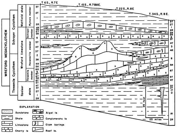
Table 2--Observed sedimentary phases of the Wreford megacyclothem.
| Formation | Member | Phase | Description | |
|---|---|---|---|---|
| Schroyer Cyclothem |
Matfield shale |
Wymore shale |
1. | Red shale |
| 2r. | Green shale, ostracodes | |||
| Wreford limestone |
Schroyer limestone |
4r. | Algal limestone | |
| 5r. | Calcareous shale, mixed fauna, Derbyia dominant | |||
| 6. | Chert-bearing limestone, brachiopod-bryozoan fauna | |||
| 5t. | Calcareous shale, mixed fauna, Derbyia dominant | |||
| Havensville shale |
4t. | Molluscan limestone, Aviculopecten, Septimyalina | ||
| 3t. | Grayish-yellow mudstone, ostracodes | |||
| 2. | Green shale, ostracodes and sparse plant remains | |||
| Threemile Cyclothem |
3r. | Grayish-yellow mudstone, ostracodes | ||
| 4r. | Molluscan limestone, Aviculopecten, Septimyalina | |||
| 5r. | Calcareous shale, mixed fauna, Derbyia dominant | |||
| Threemile limestone |
6r. | Chert-bearing limestone, brachiopod-bryozoan fauna | ||
| 6. | Chalky limestone, Fenestrellina, corals | |||
| 6t. | Chert-bearing limestone, brachiopod-bryozoan fauna | |||
| Speiser shale |
5t. | Calcareous shale, mixed fauna, Derbyia dominant | ||
| 4t. | Molluscan limestone, Aviculopecten, Septimyalina | |||
| 3t. | Grayish-yellow mudstone, ostracodes | |||
| 2t. | Green shale, ostracodes and sparse plant remains | |||
| 1t. | Red shale, charophytes | |||
| 0. | Sandstone, unfossiliferous | |||
| Numbering corresponds to that of Elias (1937, p. 411) where applicable. t=transgressive phase, r=regressive phase. End members of hemicycles are not lettered. (Minor regressions and transgressions not shown). |
||||
Comparison with Subsurface Sections
Three subsurface sections represented by well cuttings from the following localities: (1) sec. 15, T. 8 S., R. 14 W.; (2) sec. 17, T. 29 S., R. 23 W.; and (3) sec. 26, T. 21 S., R. 2 W., were studied. The heterogeneous nature of the cuttings, impossibility of accurately reconstructing sections in detail, and lack of well-preserved fossils obviated examination of a greater number of well samples, because little precise information pertaining to depositional environment would be obtained.
The significant facts that could be determined are as follows: the shales between limestone formations are in part green or red; chert is present in the Wreford limestone in all three sections, although it is sparse in section 2; and shale is a prominent part of the Wreford limestone in the subsurface, although it can be correlated only roughly with the Havensville member.
The Wreford limestone thins and the shales above and below it thicken southwestward from eastern Saline County to southeastern Barber County, Kansas, according to Lee (1949, p. 3-4). From southeastern Smith County to southwestern Meade County the Wreford limestone is gray, granular, siliceous, and, cherty in the northeast, but darker and more argillaceous toward the southwest, according to Lee (1953, p. 8). In this cross section, the Wreford formation is 12 to 40 feet thick and locally bears no chert. In a series of sections from Ford County to Wallace County, Edson (1945) shows chert in the Wreford in all wells except two in westernmost Kansas.
It may be concluded from the above statements that (1) the variation in thickness of the Wreford limestone is greater in the subsurface than at the surface; (2) cherty limestone, red shale, and green shale are prominent in the subsurface far west of the outcrop of the rocks in the Wreford megacyclothem and lie in the same relative stratigraphic positions as at the surface; (3) the depositional environment of the cherty limestone, red shale, and green shale were the same as for lithologically similar rocks at the surface and thus had great geographic range. Naturally, a given environment did not prevail simultaneously over the entire area under consideration.
Comparison with Higher Permian Strata
Good sections of the Matfield shale, Barneston limestone, and Winfield limestone at several places were measured and described and notes made on the fossils seen in each type of rock encountered.
Above the Wymore shale lies the Kinney limestone member of the Matfield formation. It contains no chert, and the fossils are dominantly mollusks. Within the limestone, calcareous shale containing Derbyia is present at exposures examined in Chase and Geary counties. The upper member of the Matfield formation is the Blue Springs shale. This exhibits an alternating sequence of grayish-green to dusky-red silty shales, the red beds predominating in the middle. Sandstone lenses exist in both sections examined (Geary County), mainly in the red shale. The upper Blue Springs member contains molluscan limestone at both exposures.
The overlying Barneston formation comprises, in upward order, the Florence limestone, Oketo shale, and Fort Riley limestone. The lower member, which was studied along U.S. Highway 40 in Geary County, greatly resembles lithologically the chert-bearing limestones of the Wreford formation and is characterized by the presence of abundant, persistent nodular beds of dark-gray chert. The fauna includes brachiopods, bryozoans, echinoderms, and fusulinids. The top of the Florence limestone includes alternating chert beds and calcareous shale units, both containing abundant fossils like those found in lithologically similar rocks of the Wreford limestone. The Oketo member consists of calcareous shale and bears the mixed fauna characteristic of this lithology. The Fort Riley limestone, which was examined in Riley and Geary counties, generally bears no chert and is dominantly characterized by a molluscan fauna. Thick-bedded limestone in the lower portion contains Aviculopinna and vertical borings similar to those in the Wreford limestone of Cowley County. Several calcareous-shale units, containing the characteristic fossils, are interbedded with the limestones in the lower part of the member. Above the fossiliferous-shale phases, argillaceous, thin- to thick-bedded limestones make up most of the upper part of the Fort Riley member. The fauna contained in these limestones is dominantly molluscan.
The Doyle shale was not examined; however, it comprises three members, which correspond closely in sequence and lithology to those of the Matfield shale. In a sinlgle known exposure chert is observed in the middle member, and Derbyia is abundant near the top of the upper member (Jewett, 1941, p. 81-82.)
Overlying the Doyle shale is the Winfield limestone, which contains three members. In ascending order these are the Stovall limestone, Grant shale, and Cresswell limestone. The Stovall consistently contains chert, and the Grant shale bears a mixed fauna typical of the calcareous-shale phase. The Cresswell limestone fauna is more or less typical of cherty limestone, but chert is common only in central and southern Kansas.
The brief studies of these formations seem to show that cyclical sedimentation very similar to that represented in the Wreford megacyclothem resulted in deposition of similar sediment in some of the younger Permian formations in Kansas.
The Matfield shale contains two red-shale phases, one in each member, which were deposited during maximum regression of the sea. The Derbyia-bearing calcareous-shale phase of the middle Kinney limestone represents the phase of maximum transgressive deposition in the formation. Sandstones in the red shale of the Blue Springs member may be compared to those of the Speiser shale in Cowley County. The upper Blue Springs is clearly transgressive, as indicated by the ascending sequence of red shale, green shale, and molluscan limestone in its higher portion.
The Florence limestone, with its fusulinids, was laid down during maximum transgression of the Barneston cycle. Fluctuation between regression and minor re-advance of the Early Permian sea is indicated by interstratified calcareous shale and cherty limestone in the upper part of the member. The Oketo member, a calcareous-shale phase, clearly is part of the regressive hemicycle. The molluscan and somewhat algal fauna of the thick-bedded limestone near the base of the Fort Riley limestone suggests a phase of sedimentation much like that observed in the upper Threemile limestone in Cowley County. In both members (Fort Riley and Threemile) these beds are found in the regressive hemicycle. The upper part of the Fort Riley member contains some rocks of the calcareous-shale type, but the dominantly molluscan limestone indicates deposition mainly during a very slow regression of the sea.
The lower member of the Doyle shale, from the base upward, shows regressive sedimentation to the red-shale phase, then transgressive units. The middle limestone member, locally containing chert, represents the maximum stage of transgression attained during the deposition of the formation. The upper member represents regression to the red-shale phase, then renewed transgression.
The chert-bearing Stovall limestone in the basal part of the Winfield formation is the maximum transgressive deposit of the cycle that begins with red shale in the upper Doyle formation. A calcareous-shale fauna is observed in the Grant shale member of the Winfield limestone, indicating that regressive sedimentation followed the deposition of the Stovall limestone member. The Cresswell member represents deposition during a re-advance of the sea, as shown by the fact that it contains chert.
Thus, the sedimentary deposits above the Wreford limestone demonstrate that sedimentation was cyclic in this part of the section also. The Barneston limestone and adjacent strata comprise the best developed single cyclothem but, where studied, do not match the Wreford formation in perfection of cyclical symmetry.
Prev Page--Rock Types || Next Page--Summary, References
Kansas Geological Survey, Geology
Placed on web Feb. 16, 2009; originally published April 1967.
Comments to webadmin@kgs.ku.edu
The URL for this page is http://www.kgs.ku.edu/Publications/Bulletins/124/04_type2.html