![]()
Prev Page--Contents || Next Page--Stratigraphy
Introduction
Purpose of Investigation
The sedimentary deposits of Wolfcampian (Early Permian) age in Kansas exhibit features of cyclical deposition as has been observed, but specific information relating to the individual formations at many places along the outcrop is wanting. The Wreford limestone (subdivided in upward order into the Threemile limestone, Havensville shale, and Schroyer limestone members) was chosen for detailed study because it is well exposed, its stratigraphy can be treated conveniently, and it is the oldest of the Kansas Permian formations to contain abundant chert.
The origin of bedded and nodular chert, of the sort seen in the Wreford limestone, has been long disputed. Study of stratigraphic and lithologic relationships of the chert was undertaken in order that light might be shed upon its origin.
The Wreford limestone was observed at as many exposures as possible as a preliminary part of the study in order that stratigraphic and geographic variations could be analyzed. Because of cyclic relationships, the Speiser shale, below the Wreford limestone, and the Wymore shale, above it, were included in the investigation. Specimens of the several rock types were studied in the laboratory to facilitate interpretation of the deposits from which the specimens were obtained. An understanding of persistence or lateral change in lithology and of stratigraphic relationships is one of the main objects of the investigation.
An interpretation of the broad faunal relationships and the specific nature of local associations of lithology and fossils is also an objective of the study. Paleoecological interpretation of the various rock types may thus be facilitated.
The major purpose of the investigation, however, is an interpretation of the setting of Permian sedimentation on the ancient shallow sea bottom. Knowledge of the depositional environment of the Wreford limestone may serve as a basis of comparison for similar deposits, older and younger, in Kansas and adjacent states and may provide information on the occurrence of economically important mineral deposits.
Previous Work
Meek and Hayden (1860) published the earliest description of the Wreford limestone. A section measured by them at Fort Riley is 40 feet thick. The rock consists of light-gray and whitish magnesian limestone, contains "Spiriger, Orthisina, Productus, Acanthocladia, and Cyathocrinus", and bears many concretions of flint in the lower part. This description is number 18 (from the top) of their generalized Permian section (1860, p. 17).
Descriptions of Permian sections are included in Swallow's report (1866, p. 11-16). The Wreford limestone comprises beds 58 to 62 of the Permian section that he measured near Fort Riley. Bed 62, the "Fifth Cherty Limestone", is the Threemile limestone member of current usage, and bed 58, the "Fourth Cherty Limestone", is the Schroyer member. The intervening beds (59-61) constitute the Havensville shale. At this locality the Wreford limestone is about 50 feet thick and contains "Productus, Chonetes, Orthisena, Athyris, Acephala, Arca, and crinoids", according to this report.
The Wreford limestone was named by Hay (1893, p. 104) from exposures near Wreford in Geary County. His brief description is inaccurate and inadequate compared to modern standards.
Several lengthy papers by Prosser (1894, 1895, 1902, etc.) on the upper Paleozoic rocks (Permo-Carboniferous and Permian) include discussions of previous investigations, revisions of nomenclature, correlations, and lists of fossils from the Wreford limestone. Prosser (1895) proposed the name Strong flint for strata previously called Wreford limestone.
The work of Beede and Sellards (1905) contains an excellent summary of Lower Permian stratigraphy in Kansas. Many measured sections are described. The scarp-forming nature of the Wreford limestone is noted and a map of its outcrop figured. Discussion of the Carboniferous-Permian boundary problem and of the Wreford limestone as the base of the Permian is presented.
Plant fossils in the Wreford limestone were mentioned by Sellards (1908) and their climatic significance was interpreted by Elias (1936).
A paper concerning the origin of the chert in the Foraker and Wreford limestones at the Kansas-Oklahoma border was published by Twenhofel (1919). He examined 500 exposures of the Wreford limestone and described several of them in detail. The chert in the Wreford limestone was judged to be penecontemporaneous (early diagenetic) in origin.
Condra and Upp (1931) named all the members of the Wreford limestone, redefined the Speiser shale, and named the Wymore shale in a very comprehensive paper pertaining to the correlation of Lower Permian rocks in Nebraska. Numerous measured sections of the Wreford limestone and adjacent shales are presented.
The first published mention of cyclic sedimentation in the Permian of Kansas is that by Jewett (1933). The sequence recognized by him as cyclical comprised the upper Speiser shale and lower Threemile limestone and constitutes but a fraction of the entire cyclothem as it is now known.
The most important paper dealing especially with the environments of deposition of the Lower Permian rocks of Kansas is that of Elias (1937). He compares Permian forms of life with presumably equivalent modern types and postulates the depth of deposition of sedimentary phases associated with each faunal assemblage of the "Big Blue Series." On the basis of his investigation, Elias set forth the ideal "Big Blue" cycle of deposition for north-central Kansas. His paper is a basic reference for ecological studies of Lower Permian strata in Kansas.
Bulletins of the Kansas Geological Survey that describe the geology of various counties containing exposures of Permian rocks, notably those by Bass (1929) and Jewett (1941), give information concerning localities where these beds may be seen. Measured sections of the Wreford limestone appear in several of these bulletins.
Although numerous published papers briefly outline the stratigraphy of the Wreford limestone and the adjacent shales, only two papers contribute importantly to interpretation of the genesis of the rocks. Twenhofel (1919), who later (1950, p. 414) cast doubt on his theory of penecontemporaneous origin of chert in the Wreford limestone, and Elias (1937) are the authors of those two papers.
Location and Description of Area
Geography
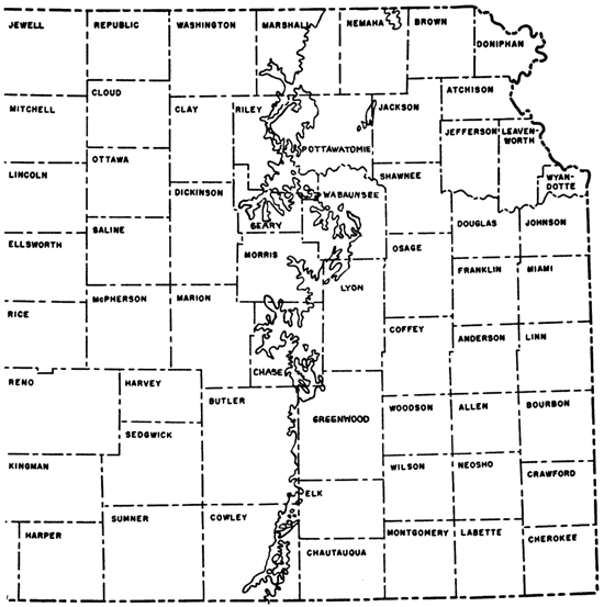
The Wreford limestone crops out in a nearly north-south belt from northern Marshall County to southern Cowley County (Fig. 1). Major re-entrants along the strike are formed by the eastward-flowing Kansas and Cottonwood Rivers, southeastward-flowing Neosho River, and southward-flowing Big Blue River. Wreford outliers in Nemaha, Pottawatomie, and Jackson counties were isolated from the main area of Wreford by erosion across the intervening Table Rock anticline. In western Pottawatomie County and southern Marshall County, Big Blue River has isolated a large area of Wreford limestone. Other outliers of considerable areal extent are situated in Wabaunsee and Cowley counties.
Figure 1--Location of Wreford limestone outcrop (adapted from Geol. Map of Kansas, 1937).
Width of the Wreford limestone outcrop is generally less than one-tenth of a mile. Where the dip decreases or where erosion has stripped back overlying formations, as in the outliers, the Wreford limestone crops out in a belt many miles wide.
Topography
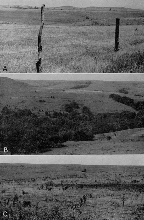
Physiographically, according to a diagram by Schoewe (1949, p. 276), the Wreford limestone crops out in the Flint Hills section of the Osage Plains from Riley and Pottawatomie counties southward, and in the attenuated Drift Border and Kansas Drift Plains of the Dissected Till Plains in Marshall, Nemaha, Jackson, and Pottawatomie counties, in the north. Glacial deposits mask much of the latter area, so exposures are poor and hard to find. The land surface is gently rolling and generally heavily vegetated. The Flint Hills section, named for the dark chert so prevalent in the limestones there, consists of a series of roughly parallel cuestas. Escarpments formed on the cherty limestones, which are separated by somewhat thicker shales, dominate the topography. The Wreford limestone, oldest of the Permian formations in which chert is consistently abundant, forms a major escarpment. Where the Wreford outcrop is narrow, the bench formed on its dip slope is subordinate to the upland surface formed on the Barneston limestone above (Pl. 4A,B). On the other hand, widespread upland surfaces develop on the Wreford dip slope in areas of broader outcrop (Pl. 4C). In the easternmost portions of its outcrop, the Wreford thus characteristically produces an upland surface or a bench below the surface developed on the Barneston limestone.
Plate 4--Topography of the Wreford limestone. A, Surface developed on the Wreford limestone. Hills in background capped by Barneston formation. SW sec. 29, T. 8 S., R. 8 E., Pottawatomie County. B, Middleground bench developed on Wreford limestone. Upland to left and in distance developed on Barneston limestone. SE sec. 18, T. 11 S., R. 7 E., Geary County. C, Upland surface on Wreford limestone outlier. SW sec. 29, T. 12 S., R. 11 E., Wabaunsee County.
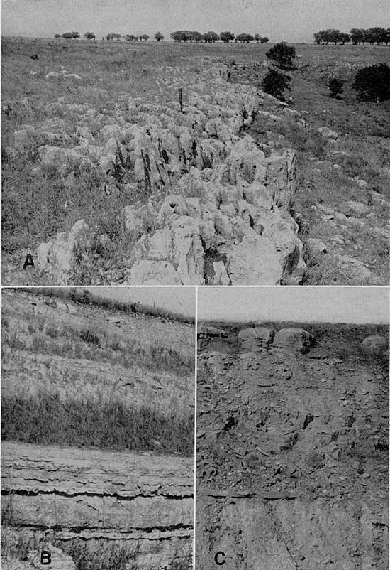
Each of the three members of the Wreford generally is expressed in the topography. Thickest and most resistant of the members is the lowest, the Threemile limestone. A ledge or low, narrow, round-edged bench is its usual expression. In areas of broad outcrop, the Threemile is commonly the only member exposed. The upper, less-cherty part of the Threemile, which weathers so as to appear porous or cavernous, is more resistant than the lower, cherty portions. A ledge or rimrock of upper Threemile limestone may be viewed continuously for miles in many parts of the Flint Hills (Pl. 5A). The more easily weathered lower Threemile limestone produces a chert-covered slope below the rimrock. Thinner and less resistant is the highest member, the Schroyer limestone, which is commonly the member on which the main part of the Wreford bench or upland surface is developed. In this situation, it crops out only as weathered cherty rubble at the edge of the bench or upland surface (Pl. 5B). Most of the few natural exposures of the Schroyer are found along streams. The most resistant unit in the Schroyer is an algal limestone at the top of the member (Pl. 5C). When weathered, the cherty basal portion, as in the Threemile member, forms a debris-covered slope. At most exposures where the Threemile and Schroyer limestones crop out close together, the Havensville member is expressed topographically as a steep slope, partly or wholly covered. Where the Wreford outcrop is broad, the Havensville shale is exposed only in the sides of gullies. In northern Kansas this member includes no resistant units except locally, but southward, as in Cowley County, a thick resistant limestone comprises most of the member and locally forms the surface.
Plate 5--Topographic expression of the Wreford limestone. A, Bench formed by resistant algal part of the upper Threemile member. Surface in distance developed on upper Wreford limestone. Cylindrical openings are clam borings enlarged by solution. Center S line sec. 24, T. 32 S., R. 6 E., Cowley County (Loc. 116). B, Upland surface developed on Schroyer limestone (top of cut). Havensville and Threemile members exposed below. NE sec. 21, T. 4 S., R. 7 E., Marshall County (Loc. 7). C, Surface developed on resistant algal limestone at top of Schroyer member. NE SE sec. 30, T. 11 S., R. 8 E., Geary County (Loc. 35).
The Wymore shale, which overlies the Wreford, and the Speiser shale, which underlies it, are characteristically slope-formers. Rare, indeed, are natural entire exposures of these units. Every complete section measured in the present investigation was studied in a highway or railroad cut. Most exposures of the upper Speiser shale are those in which the lower Threemile limestone is also exposed.
In summation, the shale units are slope-formers and rarely are completely exposed naturally. The Threemile limestone generally forms conspicuous, though narrow, benches traceable over great distances, and the Schroyer limestone is most commonly expressed as a chert-covered surface or slope. The Wreford limestone forms a conspicuous escarpment in the Flint Hills and lies directly below broad expanses of upland surface locally.
Methods of Investigation
Approximately 200 exposures were examined, and sections were measured with hand level and tape at 137 locations. Field description of sections was based on subdivision of each member into units having distinctive lithologic or paleontologic characteristics or both. Limestone units were measured and notation made of the color of fresh and weathered surfaces, hardness, and special features, such as chert, geodes, and solution cavities. For shale units thickness, siltiness, calcareousness, and color were recorded. Trenching of the shales in a direction normal to the bedding was standard procedure in exposing fresh rock. Graphic columns accompanying each description were prepared in order to show the nature of weathering, kinds of fossils, and distribution of various types of chert.
Samples for laboratory study were collected at six key localities, each chosen on the basis of completeness of the exposed section, geographic position, stratigraphic variations, or combinations of these factors. At these places at least one representative sample was selected from every lithologic unit. Each colored shale in sequences of alternating red and green shales was sampled separately. Shales were collected by means of continuous sampling in a trench cut to fresh rock. Limestones were sampled so as to include fresh rock in each specimen. Fossils were collected from the key sections and from all studied localities where well-preserved organic remains are to be seen.
In the laboratory, a series of operations was designed to gain detailed information from each sample. Limestones were cut, polished, and etched in commercial hydrochloric acid (diluted to 5 percent by volume) for a period of about 45 seconds. This brought into distinct relief the various textural and structural features of the rock. The etched surfaces were examined microscopically, and acetate peels were prepared from the etched surfaces. The acetate peels are made by immersing the etched limestone surface in acetone, then "rolling" the rock onto a piece of clear, medium-weight acetate of suitable dimensions. Orientation and identification is then recorded in india ink. After drying, the acetate is peeled off. Such peels make excellent photographic negatives and are easily stored for ready reference. Their greatest limitation lies in the lack of color contrast and compositional distinction.
Insoluble residues were made by using a modification of the method described by Ireland (1951, p. 141-142). Commercial hydrochloric acid, diluted to 30 percent by volume, was poured over a sample of limestone that had first been broken up in a small jaw crusher. The amount of limestone used was determined volumetrically in a graduated vial, the average weight being about 15 g. When effervescence ceased, the mixture was allowed to rest for approximately a minute and then decanted. The sample was then treated with more acid to insure complete digestion of all soluble materials, washed and decanted three times, and dried. The percentage of residue was determined volumetrically in a small calibrated vial. The residue was then examined by means of a binocular microscope. Volumetric analysis was used in preference to weighing samples because it is faster and because much of the residue is lost in decanting the clay and silt. The fines were not kept or studied, because they add little information to the description of the residue and tend to obscure the coarser, more diagnostic particles. Terminology used for insoluble residues is that published by Ireland and others (1947).
Chert from the key sections was cut and polished and then examined with a binocular microscope. Acid applied to the surface of the chert revealed the distribution and relative amount of calcareous material contained therein. Glycerine spread over the polished surface of the chert cut down adverse reflection and facilitated a careful examination of the matrix as well as of the enclosed structures.
Shales from the six key sections were broken down for paleontological examination by thorough drying followed by a several-hour period of soaking in kerosene. The kerosene was then decanted, water was added, and the sample was allowed to sit for a half hour or more. Washing, accompanied by decanting of the clay and silt, left a residue consisting primarily of fossils and aggregates of silt and fine sand, which was further cleaned by boiling the sample for a few minutes and washing it again. The residue was examined with a binocular microscope. The sample was sieved through 20- and 40-mesh screens to facilitate study. The percentage of calcareous material and the sand/shale ratio were determined by treating 15 g of shale with 30 percent hydrochloric acid. The residue was then sieved through a 230-mesh screen, which retained all sand-size particles. Both fractions were placed in beakers, dried, and weighed. The sand/sale ratio is determined for the undissolved residue only. Addition of residue fractions, division by 15 (the original weight in grams), and multiplication by 100 gives the percentage of residue. For two of the key sections, pipette analyses were run on several of the shale units in order to determine the amount of silt and clay-size particles in the various types of shale.
Condensed descriptions of the six key sections are contained in the appendix.
In addition to the above-described analyses of key sections, studies were undertaken to provide for more general description of rock types. Thin sections of the various rock types, including several kinds of limestone, chert, sandstone, and conglomerate, were made and studied petrographically. Numerous large blocks of limestone were etched in commercial hydrochloric acid ( diluted to approximately 30 percent by volume) in order to determine the abundance and kind of silicified fossils. In general, however, the results were unrewarding, because only a few rocks were found to contain abundant, well-preserved, silicified organic remains.
Of 137 sections measured, 120 have been used in the preparation of correlation charts of the Wreford limestone and adjacent shales (Pl. 1-3). The area between northern Nemaha County and southern Cowley County is included. Lithologies, faunas, and interrelationships of the sections are shown in these diagrams. Details of stratigraphic configuration, such as bedding, thickness and chert shapes, are accurately portrayed. (Refer to Plates 1, 2, and 3 whenever locality citations are encountered in the text.)
Acknowledgments
The field expenses of the Wreford limestone project were underwritten by the Shell Oil Company and I wish to express my sincere thanks to the officers of the company who made this support available. Especial thanks to to James Parks and Prof. Paul Tasch, who met me in the field and made many valuable suggestions concerning the satisfactory completion of the work. Thanks are also due Melville Mudge of the U.S. Geological Survey, who gave helpful information concerning location of Wreford limestone exposures. Mr. Mudge also aided in interpretation of some of the reef limestones found. Lastly, my greatest thanks go to my wife, whose assistance in the field and laboratory and whose preparation of the manuscript has been of utmost value in the completion of this investigation.
Prev Page--Contents || Next Page--Stratigraphy
Kansas Geological Survey, Geology
Placed on web Feb. 16, 2009; originally published April 1967.
Comments to webadmin@kgs.ku.edu
The URL for this page is http://www.kgs.ku.edu/Publications/Bulletins/124/02_intro.html