![]()
Prev Page--Introduction || Next Page--Rock Types
Stratigraphy
General Discussion
Main divisions of Wolfcampian (Lower Permian) rocks in Kansas, which have been long recognized by the Kansas Geological Survey (Moore and others, 1951), are as follows, in ascending order: Admire group, Council Grove group, and Chase group (Fig. 2). The Chase group (called Chase formation by Prosser, 1895), which was named from exposures in Chase County, Kansas, comprises approximately 300 feet of conspicuous ledge-forming limestones separated by shale units. The limestones are commonly interbedded with chert or flint, a characteristic feature of the Chase group; most shales between limestone formations are green or red, or both.
Figure 2--Stratigraphic classification of Wolfcampian Series in Kansas (after Moore and others, 1952).
The lowest formation in the Chase group is the Wreford limestone, which was named by Hay (1893, p. 104) from exposures of flint-bearing limestone near Wreford, Geary County, Kansas. Hay's description is as follows: "The Wreford limestone. Flints as in No. 9. Parts of the beds are silicified in localities as if by infiltration. Crinoids, syntrilasma, athyris, retzia, pinna, meekella, producti, cup corals. Twenty-five feet." The "No. 9" flints referred to are in the Florence limestone. The same description was published earlier by Hay (1891, p. 94) but Wreford was misspelled Walford. Prosser (1895, p. 772) applied the name Strong flint to the limestone and flint cropping out on top of Crusher Hill, just west of Strong City, Kansas. Earlier, in discussing the "Wreford Limestone" of Hay, Prosser (1894, p. 48) suggested that the name Ogden flint should be used if Wreford proved. an undesirable name, for Hay had mentioned exposures of this limestone near Ogden, in Riley County, at the top of the bluffs east of Three Mile Creek.
The name Wreford was adopted because it has priority and is not for any obvious reason unsuitable. Three members are now recognized (Condra and Upp, 1931). In ascending order they are (1) Threemile limestone, (2) Havensville shale, and (3) Schroyer limestone. Both limestone members are chert-bearing.
Poor exposures in the old quarry at Wreford reveal about 15 feet of somewhat chalky, fossiliferous limestone, which contains bedded chert only in its basal part. On the hill slope a hundred feet west of the quarry, 9 feet of a stratigraphically higher, thick- to massive-bedded granular limestone is exposed. Large calcareous chert nodules have weathered out from the base, and abundant minute crinoid stems are contained in the rocks near the top. Just south of the Smoky Hill River bridge on U.S. Highway 77, a mile northwest of Wreford, the same type of granular limestone may be seen, here containing very abundant organic debris and large, ellipsoidal, bluish-gray masses of calcareous chert. These and the strata cropping out at Wreford are assigned to the Threemile member, which reaches a total thickness of more than 25 feet in the type area of the formation. The Schroyer at this place (U.S. Highway 77) is much like that seen at localities 30 and 133, a few miles east and northeast, respectively, except that the basal unit and upper (algal) limestone are thicker. The total thickness of the member is about 12 feet. The Havensville shale is recognized here as a thin shaly unit, about 2 feet thick, which lies between the thick- to massive-bedded granular limestone at the top of the Threemile member and the chert-bearing limestone at the base of the Schroyer member. Thus, in the vicinity of the type locality, the Wreford formation is at least 39 feet thick.
The Threemile member is abnormally thick in the section described above and is believed to be reef-like in nature. The thickening of the upper Threemile limestone coincides with thinning of the Havensville shale. This and other reef-like bodies are discussed below.
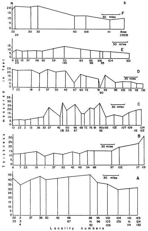
Complete sections of the Wreford limestone are scarce because the commonly thick Havensville shale member forms slopes in most places and the comparatively thin Schroyer limestone is only moderately resistant to erosion (Pl. 6A). This is especially true in northern Kansas. Southward, the shale member becomes very calcareous and much thinner, and complete sections are more numerous. The variation in thickness of the Wreford limestone across Kansas is graphically shown in Figure 3A. One can observe from this diagram that the Wreford limestone reaches its maximum thickness near the center of the state and thins appreciably southward therefrom.
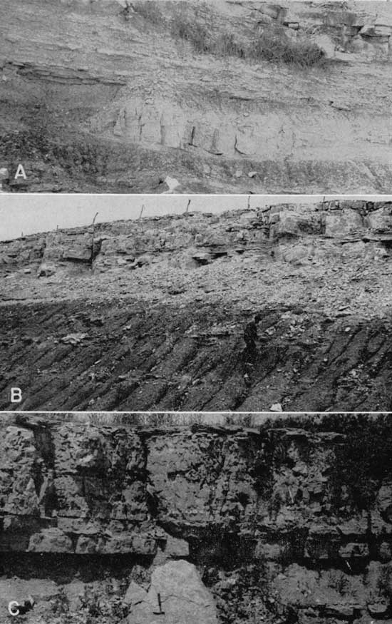
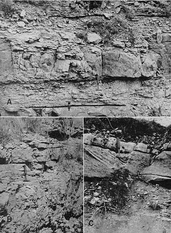
Plate 6--Exposures of the Wreford limestone and Speiser shale. A, Wreford formation on U.S. Highway 40 east of Junction City. At present this is its finest Kansas exposure. NE sec. 34, T. 11 S., R. 6 E., Geary County (Loc. 30). B, Typical exposure of Speiser shale. Wreford limestone above and Funston limestone below. NE sec. 34, T. 11 S., R. 6 E., Geary County (Loc. 30). C, Channel conglomerate in lower part of Speiser shale. NE sec. 15, T. 16 S., R. 10 E., Lyon County, (Loc. 57).
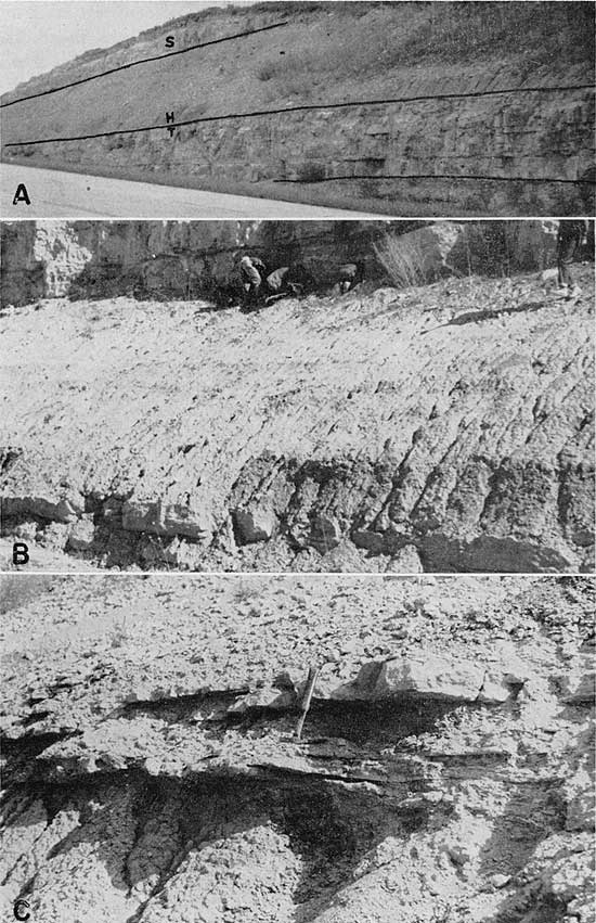
Figure 3--Thickness changes in formations and members: A. Wreford limestone. B. Speiser shale. C. Threemile limestone. D. Havensville shale. E. Schroyer limestone. F. Wymore shale.
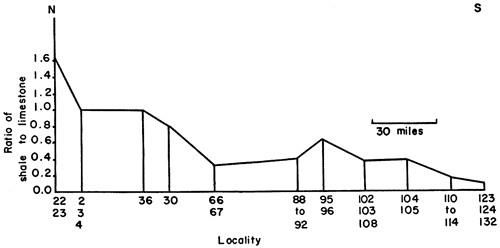
An analysis showing ratio of shale to limestone in the Wreford formation indicates that the ratio decreases markedly southward along the outcrop across Kansas (Fig. 4). Thinning of the Wreford limestone southward is correlated with decrease in shale deposition, but the basal member is thicker southward, especially in Cowley County.
Figure 4--Graphic representation of the ratio of shale to limestone in Wreford formation.
Cyclic Sedimentation
The Wreford limestone and associated shales exhibit certain repetitive features of sedimentation that may be attributed to cyclical deposition. Jewett (1933, p. 137) seemingly was the first to describe the similar sequences of lithologic types to be found in many of the formations of the "Big Blue series" (Wolfcampian) of Kansas. He recognized ten such repetitions, or cyclothems, in the stratigraphic sequence that extends from the Elmdale formation up to the Herington limestone, the following lithologic types being represented, in upward order: (1) variegated shale (red, green, brown); (2) thin limestone or calcareous-shale unit; (3) very fossiliferous gray or yellow shale; (4) thick, massive, light-colored limestone. Although Jewett discussed neither the upper parts of some of the formations, many of which contain fairly complete cycles, nor the complete cycle as it is now understood, his conclusions were reached independently. No attempt to relate organic remains to lithologic types was made by Jewett.
Elias and Moore (1934, p. 100) called attention to the distinct cyclical succession in the "Big Blue series" of Kansas, and Elias (1934, p. 366) presented the symmetrical succession of the progressive and regressive hemicycles of the "Big Blue" series. These publications are merely abstracts; no lengthy description is included therein.
Later, Elias (1937, p. 403) published a detailed discussion of the depth of deposition of the "Big Blue" sediments in Kansas. Permian cycles are defined on the basis of lithologies and faunas, and a depth zonation chart is figured. He diagrammatically illustrated his interpretation of "Big Blue" deposition, showing that the Wreford limestone, with subjacent and superjacent shales, comprises two complete cycles of sedimentation and parts of two more (Elias, 1937, p. 406). Elias' ideal Permian cyclothem (1937, p. 411) is shown in Table 1.
Table 1--Elias' ideal Permian cyclothem.
| No. | Phases established chiefly on paleontologic evidence |
Corresponding typical lithology | |
|---|---|---|---|
| 1. | Red shale | clayey to fine sandy shale rarely consolidated |
|
| Regressive hemicycle |
2r. | Green shale | |
| 3r. | Lingula phase | sandy, often varved?, rarely clayey shale | |
| 4r. | Molluscan phase | clayey shale, mudstone to bedded limestone | |
| 5r. | Mixed phase | massive mudstone, shaly limestone | |
| 6r. | Brachiopod phase | limestone, flint, calcareous shale | |
| 7. | Fusulinid phase | ||
| Progressive hemicycle |
6p. | Brachiopod phase | |
| 5p. | Mixed phase | massive mudstone, shaly limestone | |
| 4p. | Molluscan phase | clayey shale, mudstone to bedded limestone | |
| 3p. | Lingula phase | sandy, often varved?, rarely clayey shale | |
| 2p. | Green shale | clayey to fine sandy shale rarely consolidated |
|
| 1. | Red shale |
Elias states that in many cycles thalloid-like algae are found in phases 2 and 4, that massive encrusting algae may be found in phases 4 and 5, and that in the underlying Pennsylvanian strata the latter type of algae are to be found in phase 6 and rarely in 7. Also, he says that no single cycle in the Big Blue series shows all phases of the ideal cycle, that neighboring cycles above and below a given cycle commonly exhibit its missed phases, and that the Barneston and Beattie limestones are cyclically the best developed.
Red shales may have been deposited subaerially, probably near the shore of the Permian sea. Green silts are thought to represent deposition in the area slightly awash, the molluscan fauna occupied a shallow near-shore environment, and so on. The fusulinid-limestone phase was evidently deposited farthest from shore and at greater depth than the other phases. Regression of the shallow sea resulted in deposition of similar sediments bearing like organic remains, but in reverse order.
The present investigation shows general conformity of the Wreford formation to the plan of Elias' ideal cyclothem. A further discussion will follow descriptions of rock types and environments of deposition.
Speiser Shale
The name Speiser shale was proposed by Condra (1927, p. 232) to include the shales and limestones in the upper part of the so-called Garrison shale, between the "Sabetha limestone" (Crouse limestone, by priority), below, and Wreford limestone, above (Fig. 2). The various named subdivisions of the Garrison shale of Prosser (1902, p. 712), comprising shales and limestones between the Cottonwood limestone, below, and Wreford limestone, above, have been elevated to formational rank by Moore (1936a, p. 50) and the name Garrison discarded. The Speiser shale was redefined by Condra and Upp (1931, p. 23) to include the rocks between the Funston and Wreford limestones (Pl. 6B). The type locality of this formation is in Speiser Township, Richardson County, Nebraska, where the exposure consists of about 19 feet of shale including a thin limestone bed near the top.
The Speiser shale is the uppermost stratigraphic unit of the Council Grove group, the latter including, in the present classification of the Kansas Geological Survey (Moore and others, 1951), the limestones and shales from the base of the Foraker limestone to the base of the Wreford limestone (Fig. 2). The Council Grove group, and thus also the Speiser shale, was classed as Pennsylvanian by Frech (1899, p. 378); however, the Pennsylvanian-Permian boundary is now placed at the base of the Admire group (Moore and Moss, 1934, p. 100).
The Speiser shale is cyclically inseparable from the Wreford limestone. From the base of the Speiser in some localities, but from the middle in most exposures, the ascending sequence of lithologic types forms a well-defined stratigraphic pattern with regard to depositional environment. This sequence is related to the older, or first, of the Wreford cycles of sedimentation.
Three main stratigraphic subdivisions of the Speiser shale can be traced, with only minor change in facies, across the entire state of Kansas. The basal portion comprises an alternating red and green shale sequence, commonly olive gray or grayish yellow at the top. This shale ranges in thickness from about 10 feet in the northern part of the state to a maximum of 34 feet in Cowley County. In the vicinity of the type locality it is 15 to 16 feet thick. In most localities red shale lies at the base of this part of the formation and is followed in ascending order by transitional beds of red and green shale upon which lies green shale and finally grayish-yellow to olive-gray shale. At several localities green shale is found below the red, and at locality 117 grayish shale forms the base of the formation. The transitional beds present either an alternation of green and red shale or an intimate mixture of the two colors, the latter being a truly variegated shale. In northwestern Lyon County, along U.S. Highway 50N, at locality 57, a well-defined series of channel sandstones and fine-grained conglomerates is exposed in the lower part of the Speiser shale (Pl. 6C). The conglomerate is obviously local, because nearby exposures do not show this feature. In Cowley County light-colored fine-grained lenticular sandstone is a feature of the lower Speiser (Pl. 7A,B). As many as four sandstone bodies can be observed at a single exposure (Loc. 120), and at one place (Loc. 121) more than 20 feet of massive cross-bedded sandstone is exposed. At locality 117 a thin nonpersistent coal parting lies near the top of the shale. Ostracodes, especially Bairdia and Cavellina, are the dominant element of the fauna in the green and yellowish portions, and charophyte oogonia are the only fossils that were found in the red shale, these at locality 117. The basal cray shale at locality 117 contains an abundant and well-preserved mixed fauna of foraminifers, bryozoans, brachiopods, echinoderms, and ostracodes. In composition this assemblage resembles closely that of the uppermost Speiser shale, which is described below.
Plate 7--Speiser shale exposures. A, Channel sandstone in upper Speiser shale. NE sec. 12, T. 34 S., R. 6 E., Cowley County (Loc. 120). B, Channel sandstones in Speiser shale. Individual units reach 3 feet in thickness. All exhibit cross bedding. SW sec. 31, T. 33 S., R. 7 E., Cowley County (Loc. 119). C, Aviculopecten-bearing limestone in upper Speiser shale. Bed is at level of hammer head; calcareous-shale phase exposed above. SW sec. 3, T. 7 S., R. 9 E., Pottawatomie County (Loc. 2).
Near the top of the Speiser shale, generally within 3 feet of the contact with the Threemile limestone, lies a limestone phase of deposition, which is traceable, with distinct change in facies, across the entire state. To the north, the limestone is a single thick bed or two or more thinner beds and is characterized by the presence of Aviculopecten (Pl. 7C), but to the south the unit gradually thins and is shaly bedded or consists of several thin beds that alternate with gray shale. From southern Chase County to Cowley County it is commonly indistinguishable from limestones lying in the shale above, and even loses its identity locally. Septimyalina, some large orbiculoid, Juresania, and Derbyia, as well as Aviculopecten, are conspicuous elements of the fauna of this phase to the south, and Derbyia-bearing thin-bedded limestone without Aviculopecten is the first bed above the red and green shale sequence at many localities in southern Kansas. The maximum thickness of this unit in northern Kansas is 2 feet; it exceeds 4 feet in the southern part of the state where, however, the bed seems to be locally absent. The usual stratigraphic span is 0.5 to 1 foot.
The uppermost phase of the Speiser shale comprises ordinarily about 3 feet or less of very calcareous, dusky-yellow to medium-dark-gray, fossiliferous shale (Pl. 7C). In the north it contains some limestone, and toward the south thin-bedded fossiliferous limestone beds are common (Pl. 8A). This unit attains its maximum thickness of 10 feet in Butler County. The fauna is dominated by Derbyia in association with Chonetes, Composita, Dictyoclostus, Petrocrania (in northern Kansas), many genera of bryozoans (notably Thamniscus and Fenestrellina), echinoderms, ostracodes, trilobites, and foraminifers.
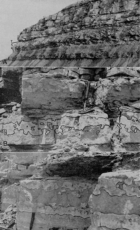
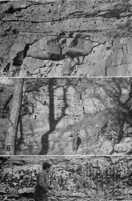
Plate 8--Exposures of Speiser shale and Threemile limestone. A, Speiser shale and Threemile limestone. Note interbedded limestone and shale in upper Speiser formation. SW sec. 19, T. 32 S., R. 8 E., Cowley County (Loc. 117). B, Basal unit of Threemile limestone showing chert bed. Note shaly phase above (at hammer head). SW sec. 3, T. 7 S., R. 9 E., Pottawatomie County (Loc. 2). C, Chert beds in basal Threemile limestone. Note calcareous shale above. SE sec. 25, T. 11 S., R. 7 E., Geary County (Loc. 32).
The Speiser shale shows a steady increase in thickness, with local variations, as one proceeds southward across the state. A minimum development of 10.1 feet is observed at locality 134 and a maximum of 39 feet at locality 119 in Cowley County. The change in thickness is presented graphically in Figure 3B.
Wreford Limestone
Threemile limestone member
The lower member of the Wreford limestone was named the Fourmile limestone by Condra and Upp (1931, p. 31) from Fourmile Creek in southwestern Richardson County, Nebraska. The thickness at this exposure is 7.5 feet. Moore (1936, p. 12) replaced the name Fourmile with Threemile, from Threemile Creek in Riley County, Kansas, because the older name is preoccupied. The exact type locality of the Threemile limestone is not stated; however, a suitable type exposure may be defined as that in the quarry in the NW SW sec. 11, T. 11 S., R. 6 E., on the Fort Riley Military Reservation, close to Threemile Creek. The thickness of the member at this locality (Loc. 133) is about 12 feet. The basal portion is covered but the rest of the member looks very similar to the rocks exposed at locality 30, about 3 miles farther south.
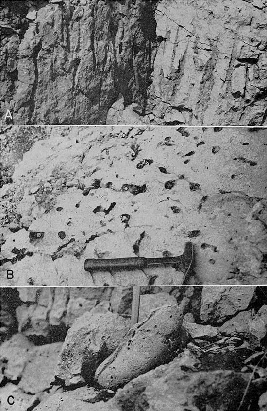
One of the most easily traceable subdivisions of the Threemile limestone is the basal thick-bedded cherty limestone unit, which is separated from the main body of limestone by a persistent body of calcareous shale or shaly to thin-bedded argillaceous limestone. The basal bed is lithologically typical of the cherty limestones to be described below. In northern Kansas the unit has the minimum thickness of 0.75 feet but in southern Kansas it reaches 4.4 feet. The average thickness of the unit at 30 localities across the state is 2.1 feet. Throughout most of northern Kansas this part of the Threemile limestone contains a single bed of chert (Pl. 8B), although as many as four distinct chert beds may be present (Pl. 8C, 9A). At many localities in central Kansas there is again only a single bed, the chert being nearly a foot thick at these places (Pl. 9B). Still farther south, in Cowley County, at some localities the chert is completely nodular and locally almost wholly absent, whereas at other exposures it exists as a single thin bed; however, as if to make up for the lack of bedded chert, silicified fossils are abundant at the latter localities. There is a marked decrease in the amount of chert in this bed from central to southern Kansas. In the Butler County area, a thick, and in some places discontinuous, bed of dark-gray calcareous chert, which exhibits roughly concentric lamination, is seen in the basal limestone.
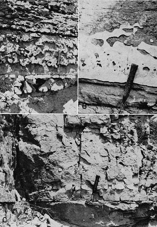
Plate 9--Chert in the Threemile limestone. A, Lower Threemile member showing several nodular beds of light-colored chert. Shaly limestone above contains abundant chert nodules. NE sec. 13, T. 22 S., R. 8 E., Chase County. B, Thick chert bed in lower Threemile limestone. SW sec. 30, T. 15 S., R. 8 E., Morris County (Loc. 66). C, Nodular-bedded chert in middle of Threemile member. SW sec. 3, T. 7 S., R. 9 E., Pottawatomie County (Loc. 2).
The fauna of the lowermost unit of the Threemile limestone is dominated by the brachiopods Composita, Derbyia, Dictyoclostus, and Enteletes. At several localities these fossils are fragmentary or absent, and there echinoderms and bryozoans of fenestrate and ramose types are dominant. Aviculopinna is found at many localities also. A zone of Wellerella in the lower part of the basal limestone unit is traceable from locality 36 in Riley County to locality 105 in Butler County. Nowhere are the specimens very abundant and they do not range through a large stratigraphic thickness, but their persistence is significant, suggesting contemporaneous deposition of the containing beds. Robust specimens of Schwagerina are found in the lowest 0.1 to 0.2 foot of the member at four closely spaced sites in central Chase County.
The second phase of the Threemile limestone is a shaly unit, which ranges in thickness from 0.1 foot in northern Kansas to as much as 2 feet in southernmost Kansas. Lithologically, the unit is variable. In northern Kansas it consists of shaly limestone (Pl. 8B), which grades into the overlying limestone. Over much of central Kansas it locally becomes a calcareous shale (Pl. 8C), a shaly limestone, or a coarse granular, tough, cavernous-weathering, resistant limestone bed. Southward from central Kansas the percentage of limestone steadily increases, and the unit is a shaly to thin-bedded limestone from southern Chase County to southern Cowley County, where it generally contains numerous irregular scattered gray chert nodules (Pl. 9A). Enteletes, Dictyoclostus, Composita, Derbyia, and Chonetes are the dominant elements in the fauna of this phase, one or more of these genera being observed at nearly every exposure. The composition of the fauna is the same, in general, as that of the upper Speiser shale.
Above the shaly limestone unit is the main thick-bedded cherty limestone of the Threemile member. The lower part of this unit lithologically resembles the basal limestone bed of the member and contains numerous beds of light- to dark-gray chert (Pl. 7C; 8B,C; 9C). Across most of Kansas these chert beds are less than 0.5 foot thick and nearly continuous, although commonly consisting of isolated nodules (Pl. 9C). In Cowley County the lower portion of the upper Threemile is characterized by the presence of abundant irregular chert nodules in place of bedded chert.
Some of the chert beds locally in northern Kansas contain nuclei or marginal portions of dark-gray concentrically layered calcareous chert. South of southern Chase County, this type of chert becomes more and more prominent. In Cowley County one massive, nearly continuous bed reaches a thickness of 1 foot at some exposures (Pl. 10A,B,C). One or two other almost continuous beds of this same type are contained in the upper Threemile limestone in the Cowley County area (Pl. 11A).
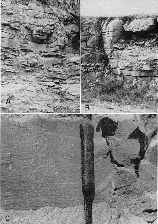
Plate 10--Calcareous chert in the Threemile limestone. A, Nodules of thick-bedded, bluish-gray, calcareous chert in middle of Threemile limestone. SW sec. 19, T. 32 S., R. 8 E., Cowley County (Loc. 117). B, Thick-bedded, bluish-gray, calcareous chert bed. Same bed as "A," above. Algal unit at top. SW sec. 19, T. 32 S., R. 7 E., Cowley County (Loc. 115). C, Detail of bluish-gray, concentrically layered, calcareous chert. Same bed as "A" and "B," above. Note nodule of noncalcareous chert in lower right (arrow). SW sec. 19, T. 32 S., R. 7 E., Cowley County (Loc. 115).
The next higher part of the Threemile limestone exhibits one of the more interesting phases of Wreford sedimentation. In northern Kansas it is thick- to massive-bedded, light-colored, pitted, somewhat chalky limestone that contains little chert (Pl. 11B). Where present, chert forms thin continuous beds or isolated flattened nodules. Layered calcareous chert is associated with the noncalcareous variety at many exposures. Huge spheres and subspherical masses of calcareous chert lie near the top of the chalky limestone at locality 90 (Pl. 11C, 12A). The thickness of the chalky limestone ranges from about 2 to 5 feet in the area between Marshall County and western Wabaunsee County. Between southern Wabaunsee County and southern Chase County the chalky limestone is abnormally thick at many places (Pl. 12B). Thicknesses of 10 to 25 feet have been observed for this unit. Such abrupt thickening of the unit in very short distances indicate a reef-like nature. Across northern and central Kansas the chalky limestone typically weathers with a pitted to cavernous surface and is a resistant ledge former.
Plate 11--Chert in the upper Threemile member. A, Calcareous chert bed near base of algal unit in upper Threemile. NW sec. 30, T. 33 S., R. 7 E., Cowley County (Loc. 118). B, Chert in upper chalky portion of Threemile member. Note pitted surface of limestone, and thick chert bed above. SE sec. 25, T. 11 S., R. 7 E., Geary County (Loc. 32). C, Spheroidal nodule of calcareous chert in upper Threemile limestone. SE NW sec. 19, T. 22 S., R. 8 E., Chase County (Loc. 90).
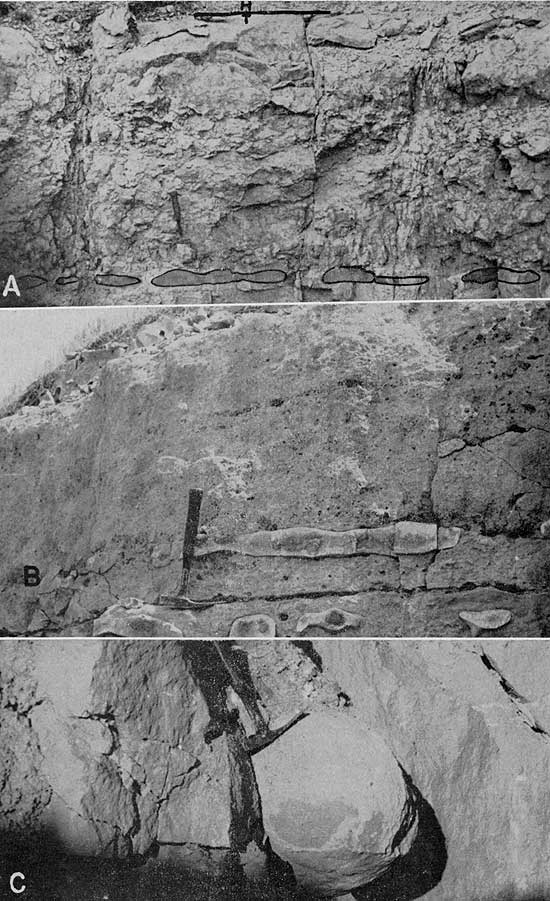
Plate 12--Features of the upper Threemile member. A, Calcareous chert in upper Threemile limestone. Note irregular shape of nodule and thinness of Havensville shale at this locality. SE NW sec. 19, T. 22 S., R. 8 E., Chase County (Loc. 90). B, Reef in upper Threemile limestone. Member reaches its maximum thickness here. S2 SE sec. 26, T. 13 S., R. 9 E., Wabaunsee County (Loc. 135). C, Clam borings in upper Threemile member. Center S line sec. 24, T. 32 S., R. 7 E., Cowley County (Loc. 116).
This part of the Threemile limestone loses its characteristic appearance south of the Matfield Green area of Chase County; although it retains a somewhat chalky lithology as far south as southern Butler County, several persistent chert beds appear. In Cowley County the entire upper part of the member is granular, mostly chert bearing, light yellowish brown, and massive to thin bedded, and may be divided into an upper and a lower subdivision. Because the lower of these two subdivisions lies in the same stratigraphic position as the chalky limestone and because of certain faunal characteristics (as discussed below) it is thought to be a facies equivalent of the chalky limestone.
Megafossils found in the chalky limestone consist mainly of fenestrate and ramose bryozoans associated with brachiopods and with spines and plates of echinoids. Fenestrellina and Composita are nearly ubiquitous forms in these rocks. Among the brachiopods, Dictyoclostus, Derbyia, and Chonetes are found at some exposures. At many localities, especially those where the chalky limestone reaches reef-like proportions, fenestrate bryozoans are by far the most abundant group of organisms. The cup corals Stereostylus and Dibunophyllum are to be found at most localities. Echinoid spines and crinoid stems are present in all reef sections. At the change in facies noted in Butler and Cowley counties the lower portion of the upper Threemile limestone is characterized by dominant brachiopods (Derbyia, Dictyoclostus, Composita) and it contains echinoderm remains associated with profuse productid spines. In short, there is little difference from the fauna of the chalky limestone except in relative abundance. It may be stated generally that the chalky limestone and its southern equivalent are sparsely fossiliferous, only locally containing an abundance of megascopic organic remains.
In northern and central Kansas the uppermost part of the Threemile member is lithologically similar to the limestone that lies directly above the shaly break near the base of the member. As compared with the underlying chalky limestone, the amount of chert is notably increased (Pl. 11B), likewise the abundance and variety of fossils. In most places this part of the Threemile member is 2 to 3 feet thick. In northern Kansas, especially, the uppermost portion is commonly a shaly-bedded limestone, which in some places contains small chert nodules and bears a sparse fauna of brachiopods, crinoids, and bryozoans. The faunal assemblage is intermediate in composition between that of the calcareous shale of the upper Speiser shale and that of the cherty limestone. In central Kansas, over the thick reef limestone, the uppermost part of the member is a hard, thick-bedded, slightly cherty limestone, which is in sharp contact with the overlying shale, there being no transitional phase of shaly limestone. At most exposures where reef-like thickenings are observed, corals of the genus Dibunophyllum are abundant at the top of the member.
An algal bed lies at the top of the Threemile limestone in the area between northeastern Butler County (Loc. 103) and southern Cowley County. At its northernmost exposure in Butler County it is 3 feet thick; it reaches a maximum of 6.75 feet in thickness south of Dexter, Cowley County (Pl. 11A). The minimum observed thickness of this bed is 1.25 feet in southern Butler County, locality 107. Characteristically, the algal bed is very resistant to weathering and forms a prominent bench wherever it crops out (Pl. 5A). The exposed surface is pitted to cavernous. Paleontologically, the bed assumes great importance because of its position in the cycle of deposition, as will be discussed under environments of deposition. The fossils include many Osagia-like algae at most exposures. These are somewhat sparser at the base of the bed, although the distribution is almost uniform. Mollusks such as Aviculopinna, Allorisma, Schizodus, Astartella, Bellerophon?, and, more rarely, Aviculopecten and Septimyalina constitute the group of invertebrates. Also present is an assortment of brachiopod, bryozoan, echinoid, and crinoid remains. At all exposures from localities 115 and 117 southward to the Silverdale area of Cowley County, vertical tubular openings can be observed in the algal bed; they start near the base and extend more than halfway through the bed. The openings are numerous at many places, locality 116 being an excellent example, and they range from less than 1 inch to 3 inches or more in diameter (Pl. 12C, 13A,B). Boring clams such as Aviculopinna and Allorisma are found at each locality where the burrows are exposed, stratigraphically at or near the bottom of the tubular openings. They are oriented almost invariably in a vertical position and commonly occupy the bottoms of holes. Twenhofel (1919, p 410) believed the openings to be worm burrows, but in light of the presence of large burrowing clams in some of the holes it is almost certain that they were made by these mollusks (Pl. 13C).
Plate 13--Clam borings in the upper Threemile limestone. A, Detail of clam borings. Center S line sec. 24, T. 32 S., R. 7 E., Cowley County (Loc. 116). B, Plan view of clam borings. Center S line sec. 24, T. 32 S., R. 7 E., Cowley County (Loc. 116). C, Clam at base of boring. SW sec. 19, T. 32 S., R. 8 E., Cowley County (Loc. 117).
Chert is rare in the algal bed, but close to the base of the unit a fairly persistent but thin, discontinuous bed of concentrically layered bluish-gray calcareous chert is found at most of the exposures in Cowley County (Pl. 11A). Sparse small nodules of gray Osagia-bearing chert lie in the upper part of the algal bed locally.
Throughout its outcrop area the algal bed forms a distinctive ledge, especially in Cowley County, north and east of Dexter in the area traversed by Kansas Highway 38. The borings in the bed become very large upon weathering and form a conspicuous "pipe rock" that has a rough, fluted surface (Pl. 5A).
The observed thickness of the Threemile limestone ranges from 6.25 feet in Marshall County (Loc. 7) to slightly less than 33 feet in Wabaunsee County (Loc. 136), where a reef-like expansion in the upper part augments the normal development. The thickness is about 30 feet at localities 66 and 67 in Morris County and at locality 90a in Chase County. The great thickness at these places also is due to reef development. Throughout Cowley County the member commonly is about 20 feet thick. Changes in thickness of the member are illustrated in Figure 3C.
Havensville shale member
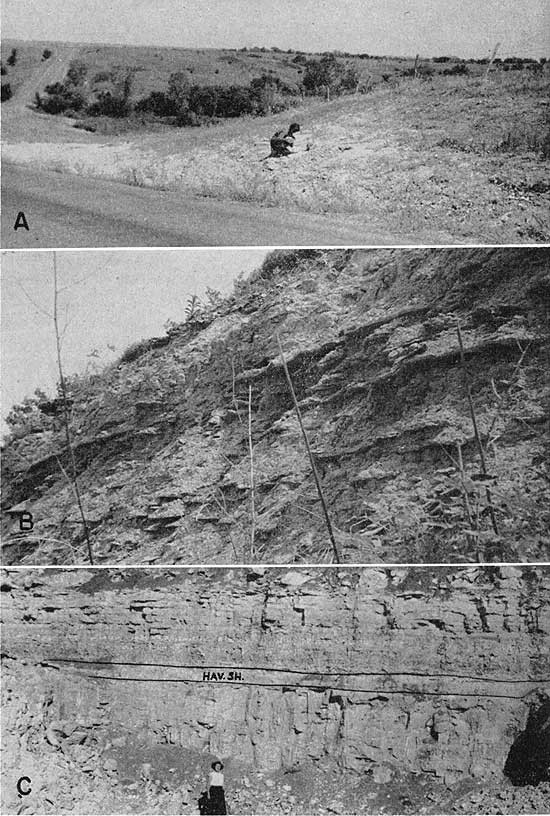
The middle member of the Wreford limestone was named by Condra and Upp (1931, p 32) from exposures in cuts on Kansas Highway 63 about 2 miles south of Havensville in Pottawatomie County, Kansas (Pl. 14A). They state that the thickness of the Havensville shale at the type locality is 18 to 19 feet, but 5 feet of shale and limestone at the base is not definitely assigned to either the Threemile limestone or the Havensville shale. On the basis of close examination of the lithology and paleontology of the lower Havensville at numerous localities in northern Kansas the writer would certainly place these questioned beds in the Havensville member. At the same place a limestone bed and overlying shale unit, both included as the lower 3 feet of the Schroyer limestone by Condra and Upp (1931, p. 34), are also lithologically and paleontologically a part of the Havensville shale. Thus the thickness of this member at the type locality is 27 feet. From north to south across Kansas a great variation in the thickness of this middle member of the Wreford limestone is observed. The maximum development is 27 feet at the type locality in Pottawatomie County. Throughout northern Kansas as far south as locality 42 in Wabaunsee County the thickness is approximately 23 feet except at locality 2, where it is only 18.8 feet (Pl. 14B). The minimum thickness of the member is only 1.5 feet at locality 90 (Pl. 14C). At all exposures where the upper Threemile member contains reef limestone the Havensville shale is abnormally thin. In southern Kansas the Havensville member is thin and exhibits remarkable development of thick-bedded limestone. It is only by careful observation that the member can be traced with certainty into Cowley County from Butler County. South of locality 90 the member thins steadily from 16.2 feet at locality 93 in Chase County to 5.5 feet at Silverdale in southern Cowley County.
Plate 14--Exposures of the Havensville shale. A, Havensville member at the type locality. SW sec. 34, T. 6 S., R. 12 E., Pottawatomie County (Loc. 18). B, Thin development (19 feet) is unusually small for this part of Kansas. SW sec. 3, T. 7 S., R. 9 E., Pottawatomie County (Loc. 2). C, Minimum thickness of the Havensville shale. At this exposure it is only 1.5 feet thick, owing to great thickening of the upper Threemile limestone. SE NW sec. 19, T. 22 S., R. 8 E., Chase County (Loc. 90).
Although dominantly a shale unit, at nearly all localities the Havensville member contains one or more limestone beds of fairly distinctive lithological and paleontological character. Over much of Kansas the basal part of the member is a shale, which ranges in thickness from 0.5 to 10.5 feet and is generally characterized by a mixed fauna consisting mainly of brachiopods, bryozoans, ostracodes, foraminifers, crinoids, echinoids, and trilobites. The fauna is much like that found in the upper Speiser shale. At most places the fossils are fragmentary and sparse, but at some exposures they are well preserved and abundant.
In northern Kansas, as far south as locality 72, the second unit is generally a hard calcareous shale, shaly limestone, or limestone unit, which contains the diagnostic genera Aviculopecten and Septimyalina. Because the Havensville shale shows great changes of thickness and because at some exposures either the limestone bed is absent or several limestone beds are present, it is difficult to judge which beds are equivalent to those of other localities. The lithology, as well as the thickness and position of the limestone beds, changes enough to make correlation uncertain. The unit just described is a good example. In some places it contains only mollusks and is very shaly; in some others it is absent altogether; in still others it is a hard limestone. Position in the stratigraphic succession and faunal composition are the the best keys to identification of such beds. Even paleontologically there are significant variations. Brachiopods, crinoids, echinoid remains, and bryozoans are common in the pecten bed.
At many exposures the pecten bed is overlain by a shale or, at some exposures, a mudstone, which contains few megafossils; it contains a well-preserved though restricted microfauna, dominantly of ostracodes, at locality 30. Where megafossils are present, Aviculopecten and Septimyalina are the typical forms. At many localities, especially in the area north of Geary County, a very argillaceous, sparsely fossiliferous, thin-bedded limestone lies within the shale. At localities 50 and 55, and just west of locality 54, the central portion of this shale unit is a very dusky yellow-green to grayish-green shale that strongly resembles the green strata in the Speiser shale. Fossils in the greenish shale include ostracodes, especially Bairdia and Cavellina, and fragmentary vertebrate remains. At locality 18, the type of the Havensville, a well-preserved Neuropteris flora is seen in yellowish-gray mudstone, which lies between overlying pale olive shale and underlying molluscan-limestone beds. The mudstone and pale olive shale occupy the same stratigraphic position as the shale containing greenish beds at locality 55. Sellards (1908, p. 387) and Elias (1936, p. 696) mention plant fossils from the Havensville shale of Butler County, but the forms there are Walchia, Callipteris, and Cordaites. A thin- to thick-bedded, somewhat argillaceous limestone lies next higher stratigraphically. The fauna of this unit is observed to be molluscan at some exposures, mixed brachiopod, bryozoan, trilobite, and echinoderm at others, and at a few places, molluscan at the base and mixed at the top. Where the fauna of the bed is wholly molluscan, algal structures are not uncommon. At locality 13 a resistant, bench-forming thick-bedded limestone containing an algal-molluscan fauna is observed in this stratigraphic position. In this area the top unit of the Havensville member is commonly a shale or mudstone. It contains either an abundant mixed fauna that lacks mollusks, or only a sparse assemblage of microfossils. Lingula and Orbiculoidea are abundant in mudstone at the top of the Havensville shale at locality 32.
Thus, in its northern exposures, the Havensville member shows a rough but observably symmetrical pattern of sedimentation. The lower half of the member includes sediments much like those of the upper Speiser shale, but in reverse stratigraphic order; the upper Havensville sequence resembles roughly that of the upper Speiser. At only four observed exposures north of locality 72, however, does the sequence that represents regressive sedimentation include the green-shale phase of Elias' ideal cyclothem. Absence of the green shale indicates that subaerial deposition definitely did not occur during accumulation of the Havensville, at least not in the area of these outcrops.
A variety of patterns of sedimentation is seen in exposures of the Havensville shale south of locality 72. In northern Chase County only one limestone unit is observed, this occupying an essentially central stratigraphic position in the member, although it probably lies almost directly on the Threemile limestone at locality 77. A mixed fauna, including Derbyia, Dictyoclostus, Composita, echinoids, crinoids, and bryozoans of ramose and fenestrate types, is found in the lower shaly unit in association with sparse specimens of Aviculopecten. The limestone unit is characterized by an abundant mixed fauna at the base, including a few gastropods, and a dominantly molluscan fauna in the upper part. In this area the upper Havensville shale was observed to contain megafossils at only one locality (Loc. 77); the fossils constitute a mixed fauna like that of the upper Speiser shale.
Very calcareous shale predominates throughout much of the Havensville member at localities 83 and 93, except for 2 or 3 feet of less calcareous shale at the top. A mixed fauna is characteristic; Aviculopecten is found only sparingly.
The Havensville sequence is of much different aspect at localities 67 and 90, where reef-like thickening of upper Threemile limestone hindered deposition of Havensville shale. At locality 67 there is 5 feet of shale, the lower portion very calcareous and bearing a mixed fauna; at locality 90 only 1.5 feet (Pl. 14C) of blocky shale containing an Ammodiscus and fish fauna is found.
Two limestones at localities 95 and 108 both contain elements of a mixed fauna; southward from these exposures, in Butler and Cowley counties, a single prominent limestone unit is included in the Havensville shale member Pl. 15A,B). This limestone contains both molluscan and mixed faunas. Aviculopinna and, less commonly, Allorisma, can be observed in the limestone in Cowley County; clam borings like those of the upper Threemile are fairly numerous. The bed is progressively more algal to the south. Cross-bedding of the lower part of the unit is conspicuous at locality 124 (Pl. 15C). At several exposures small sparse chert nodules are contained in the limestone. Mixed faunas are characteristic of the shale units in Butler County. In Cowley County a sparse Aviculopecten and fish-tooth assemblage is observed in the shale below the limestone, and an algal-molluscan or mixed assemblage is seen in the calcareous shale above it.
Plate 15--Limestone in the Havensville member. A, Thick-bedded limestone in the Havensville shale of southern Kansas. NW sec. 30, T. 33 S., R. 7 E., Cowley County (Loc. 118). B, Limestone phase of Havensville shale. SW sec. 19, T. 32 S., R. 7 E., Cowley County (Loc. 115). C, Cross-bedded limestone in middle of Havensville shale. Below lies basal Havensville in contact with thick-bedded upper Threemile limestone. NW sec. 10, T. 34 S., R. 6 E., Cowley County (Loc. 124).
Thickness variations of the Havensville member are plotted in Figure 3D.
Schroyer limestone member
The upper member of the Wreford limestone was named by Condra and Upp (1931, p. 33) from exposures 1 1/4 miles south of Schroyer, Marshall County, Kansas. A thickness of 22 feet 2 inches is cited, but no exposure examined during the present study includes more than 13 feet of what can be called Schroyer limestone. The member is about 13 feet thick 3/4 mile south of the type locality, according to Walters (1954, p. 107). Across all of Kansas the basal part of the Schroyer member, a cherty limestone containing a brachiopod-bryozoan fauna, lies on shale or, in a few places, noncherty argillaceous limestone (Pl. 16A,B). If a member may be defined as containing rocks of characteristic and persistent lithology, then much of what has been called Schroyer at the type locality should be included in the Havensville shale. Limestones lying below cherty limestone near the town of Schroyer are very argillaceous, bear no chert, and in addition, are faunally distinct from those containing chert. At several places in Marshall and Pottawatomie counties the upper Havensville shale includes a molluscan-limestone phase, which contains Aviculopecten and other pelecypods. Locally, as at Schroyer, the limestone thickens and is contiguous with overlying cherty limestone. At first appearance the molluscan limestone seems to belong in the Schroyer member. Placement of this unit in the Havensville member, however, is harmonious with respect both to cycles of sedimentation and to observed thicknesses of more shaly exposures of the Havensville at nearby outcrops. Therefore only 5 feet of cherty limestone at the type section should be classified as Schroyer, and at present only 1.6 feet of the Schroyer is actually exposed. Other sections measured by Condra and Upp (1931, p. 33-35) likewise include beds that are typically Havensville in lithology (very argillaceous) and stratigraphic position. The boundary between the Schroyer limestone and Havensville shale is here placed at the contact of chert-bearing limestone on shale or noncherty argillaceous limestone, the strata above and below the contact thus being lithologically and stratigraphically compatible units. This is done with the object of providing a firmly established datum, which can be traced over great distances.
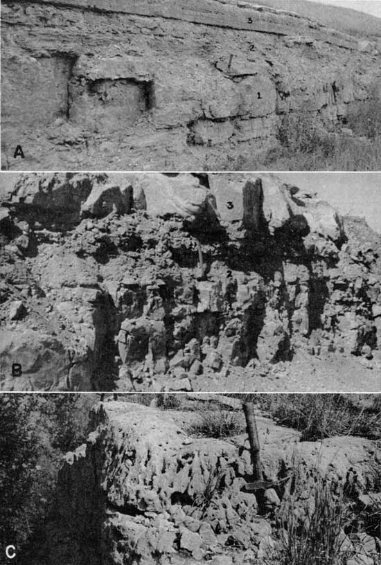
Three units are invariably present in the Schroyer member. In upward order these are: (1) a basal cherty limestone, which locally contains some shale in northern Kansas (Pl. 16C), (2) a shaly unit, which commonly contains a cherty limestone bed, and (3) an algal limestone (Pl. 17A,B). The first of these units is remarkably persistent laterally and consists of brachiopod-bearing limestone interbedded with light- to dark-gray chert, some of which is the layered calcareous type. Three to six beds of chert may be observed at the various exposures. In Cowley County the chert beds are less persistent, being generally represented by large nodules that show definite parallelism to bedding (Pl. 17C). Thin-bedded cherty limestone at localities 35 and 70, and medium-bedded chert-bearing limestone below a thin shale unit at locality 67 provide the only observed exceptions to the generalization that thick-bedded cherty limestone forms the basal unit of the Schroyer member.
Plate 16--Lower Schroyer limestone. A, Schroyer-Havensville contact (1.5 feet above hammer handle). Upper Havensville is very calcareous. Type locality of the Havensville. SW sec. 34, T. 6 S., R. 12 E., Pottawatomie County (Loc. 18). B, Sharp contact of Schroyer limestone on Havensville shale. NE SW sec. 11, T. 11 S., R. 6 E., Riley County (Loc. 133). C, Basal cherty limestone of Schroyer member. Note shaly phase above hammer head. SW sec. 3, T. 7 S., R. 9 E., Pottawatomie County (Loc. 3).
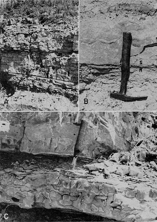
Plate 17--Schroyer limestone. A, Exposure of Schroyer member showing (1) basal chert-bearing phase (hammer), (2) middle shaly phase (contains a chert-bearing limestone near the top), and (3) thick-bedded algal bed, in upward order. NE sec. 34, T. 11 S., R. 6 E., Geary County (Loc. 30). B, Threefold division of the Schroyer limestone showing in upward order (1) basal chert-bearing limestone, (2) middle shaly phase (with chert-bearing limestone at end of hammer handle), and (3) thick-bedded algal unit. NE sec. 34, T. 12 S., R. 5 E., Geary County (Loc. 137). C, Lower Schroyer member. Note nodular chert layer below hammer head. NW sec. 30, T. 32 S., R. 7 E., Cowley County (Loc. 115).
Derbyia, Composita, and Dictyoclostus are the dominant fossils at many exposures. Fenestrate and ramose bryozoans, crinoids and echinoids, and more rarely, Aviculopinna, trilobites, and corals constitute other important faunal elements.
A minimum thickness of 3.1 feet is observed for the basal cherty limestones at localities 91 and 122 in Chase and Cowley counties. The maximum development is 5.9 feet at locality 35 in Geary County. In all places where thickness exceeds 5 feet the additional thickness is due to the presence of thin-bedded cherty limestone that underlies the thicker beds.
Above the basal cherty portion of the Schroyer member is a shaly unit, which at most places, especially in northern Kansas, contains a thin- to thick-bedded cherty limestone (Pl. 17A,B). The chert is light to dark gray and is locally absent. The limestone is either isolated within the shale or in contact with the overlying algal limestone. At some exposures, localities 70, 108, and 123 being examples, noncherty limestone almost wholly takes the place of the shale. The fauna of the shale is typically mixed and includes the brachiopods Derbyia, Dictyoclostus, Composita, and Chonetes. Fenestrate, ramose, and massive bryozoans, echinoderm remains, corals, trilobites, abundant ostracodes, and rare specimens of Septimyalina are also present. Minute juvenile fusulinids are found in the basal part at localities 67, 93, and 108. Brachiopods, bryozoans, and fragmentary echinoderms are dominant in the cherty limestone. The minimum thickness of the shaly unit is 0.8 foot (Loc. 123). The maximum thickness of 9.5 feet is observed at locality 83.
At all localities where the contact with the overlying Wymore shale is exposed (Pl. 17A,B), the uppermost unit of Schroyer limestone is a thick-bedded algal limestone. At most other localities an algal bed is present in the same stratigraphic position, but absence of higher beds in the Schroyer cannot be proved because Wymore shale is not exposed above. Enough widely distributed sections are known to indicate that the algal bed is almost certainly the uppermost unit of the Schroyer member across all of Kansas. The bed, which is hard and resistant, forms a bench along its outcrop and characteristically is pitted or even somewhat cavernous on weathered surfaces.
Osagia-like algae are ubiquitous in this persistent unit, and in most exposures they are accompanied by minute gastropods, ostracodes, crinoid fragments, brachiopod fragments, and bryozoan debris. Locally, pleurotomariids, Aviculopecten, and other mollusks are present. Some difference in shape of the algal colonies is observed, not all being Osagia. Minimum thicknesses of 0.95 foot (Loc. 108) and 1 foot (Loc. 9, 83) have been observed for this unit. A maximum thickness of 4.25 feet of algal limestone can be seen at locality 96. The average thickness of this unit is 2.1 feet for 17 localities across Kansas.
The Schroyer limestone maintains a fairly uniform lithology throughout the state and shows the least lateral variation of any member of the Wreford formation. The most marked change observed in the member is a thinning southward and northward from central Kansas. This is graphically shown in Figure 3E.
Matfield Shale
General statement
The 60 feet or so of shale and limestone lying between the Wreford limestone and the Florence flint was named the Matfield formation from exposures in Matfield Township, Chase County, Kansas, by Prosser (1902, p. 714). Three subdivisions have been recognized. In ascending order they are the Wymore shale, Kinney limestone, and Blue Springs shale members (Condra and Upp, 1931, p. 37-38).
Wymore shale member
This member was named from exposures 2 1/2 miles east of the south side of Wymore, Nebraska, by Condra and Upp (1931, p. 37). A thickness of 22 feet is known at the type locality.
Only a few complete sections of Wymore shale could be located, because the thickness of the member and the relatively unresistant character of the overlying Kinney limestone commonly result in slopes that are covered completely or only poorly exposed. Generally only the upper part of the Wymore member can be seen at sites where the Kinney crops out. At some places the basal Wymore shale is exposed in gullies for a short distance above the upper Schroyer limestone. Although few localities revealed all of the Wymore shale, several sections that are almost completely exposed were noted. Most of the exposures recorded in older reports are now almost completely covered.
The Wymore shale generally exhibits a fourfold depositional sequence. In upward order lie: (1) silty green shale, (2) silty red shale and red mudstone, (3) silty green shale, and (4) very silty shale, very calcareous mudstone, or hard, very silty limestone. Locally, there is thin interbedding of green and red portions near the contact; at some other exposures, alternating red and green hues are seen throughout the lower part of the member. A thin, sparsely fossiliferous limestone lies between the first reddish zone and the second greenish zone at locality 4. A purplish-red, very calcareous shale lies above the base of the member at locality 30, and a nodular limestone is seen in the basal green portion at locality 108. Condra and Upp (1931, p. 40) describe a nodular limestone near the base of the Wymore shale at locality 111, but such a limestone is not mentioned by Bass ( 1929, p. 75) or Beede and Sellards (1905, p. 104) and was not seen during the present investigation. Moore and others (1951, p. 45) state that beds of limestone and fossiliferous shale are included in the lower part of the Wymore shale in southern Kansas, but no published section that includes such limestones could be located, and on exposures examined in southern Kansas contain limestone.
The green shales of the Wymore contain a fossilized biota that is dominantly composed of ostracodes, especially Bairdia and Cavellina, but charophytes and vertebrates are also represented. Charophyte oogonia are rare except at locality 4. Some high-spired gastropods can be collected in the basal 0.5 foot of the lower green shale at locality 30. In places the green shales are nearly unfossiliferous, and the red shales are everywhere unfossiliferous. Mottled red and green shale commonly contains ostracodes. It has been observed that the silty green shales are less fossiliferous than the clayey green strata. Fossils in the silty shale or calcareous mudstone in the upper Wymore member are known only from localities 24, 30, and 93.
The greatest observed thickness of the Wymore beds is 26 feet (Loc. 37), and the minimum thickness is 9 feet (Loc. 111). Bass (1929, p. 75) reports about 10 feet of Wymore shale a mile north of the Oklahoma line south of Silverdale, Kansas. Progressive southward thinning of this member is indicated in Figure 3F.
Prev Page--Introduction || Next Page--Rock Types
Kansas Geological Survey, Geology
Placed on web Feb. 16, 2009; originally published April 1967.
Comments to webadmin@kgs.ku.edu
The URL for this page is http://www.kgs.ku.edu/Publications/Bulletins/124/03_strat.html