![]()
Prev Page--Ellis County || Next Page--Dakota Sandstone
Part II--The Geology of Hamilton County, Kansas
Field Work
A few weeks in August and September, 1924, were spent in and near Hamilton County obtaining the data upon which this report is based. Inasmuch as the south half of the area is within the boundaries of the Syracuse and Lakin quadrangles, which were described by Darton in 1920, much time in searching for outcrops in the field was saved by reference to Darton's geologic map. The purpose of the field study was to determine as nearly as possible the configuration of the Syracuse anticline shown in a generalized sketch map by Darton. There are few exposures of the rocks involved in the Syracuse fold, the surface being occupied by unconsolidated sediments that are unconformable with the folded strata and were deposited subsequent to the time of folding. It was therefore necessary to determine the stratigraphic section in detail in order that the available outcrops might be correctly assigned in the stratigraphic column.
A detailed section of the rocks was measured, in part in Kearny County on the north side of Arkansas river, in part in southern Hamilton County in T. 26 S., R. 41 W., and in part farther north in Hamilton County in Ts. 22 and 23 S., R. 42 W., and T. 22 S., R. 43 W. Altitudes were determined in Ts. 25 and 26 S., R. 41 W., in T. 26 S., R. 42 W., and in the eastern part of Ts. 22 and 23 S., R. 42 W., by telescopic alidade and plane table. In the remainder of the south half of the county the locations of outcropping strata were sketched on the United States Geological Survey's topographic map of the Syracuse quadrangle. No topographic survey of the north half of the county has been made, and so in that area outcrop locations were sketched on a map (scale 1 inch to 2 5/8 miles) issued by the county clerk's office at Syracuse, and altitudes were determined by aneroid readings. For the determination of structure a large number of water wells drilled to the Dakota sandstone in the south half of the county were visited and located on the Syracuse topographic map. Records of a few wells in the north half of the county were obtained.
No attempt was made to visit every outcrop in the north half of the area nor to determine accurately the areal distribution of the formations. The field work was done to determine the structure of the region, and the areal geologic map (Pl. V) was compiled in the office from the data gathered in the course of the structural work. This map is consequently of a distinctly reconnaissance type.
Samples of drill cuttings from the Wood Oil Co.'s well, in sec. 5, T. 26 S., R. 41 W., Hamilton County, were studied during the winter of 1924-25, as drilling progressed. Temperature readings in the well were taken the first week in April, 1925, when the drill had reached a depth of 4,650 feet.
Acknowledgments
Splendid cooperation in the field work was given by a great number of ranchers in the county, residents of Syracuse, and the county officers. Special thanks are due to Fred Hoppe, of Syracuse, who assisted in the plane-table work and part of the time in collecting water-well records. Appreciation of the many courtesies accorded by W. S. McCray, Clyde Smith, and E. L. Orr, of the Wood Oil Co., and the drillers and tool dressers of the same company, particularly for their painstaking care in saving complete sets of samples of drill cuttings from their well is gladly expressed. The writer is indebted to W. C. Mendenhall for suggestions during a short visit to the area while field work was in progress, and to W. T. Thom, Jr., and R. C. Moore for valuable criticisms in the compilation of the data.
Location, Topography, and Culture
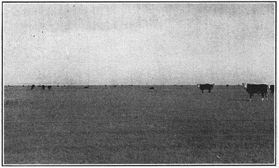
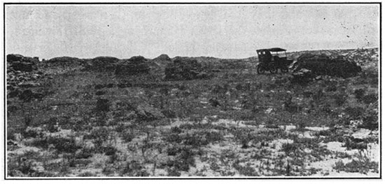
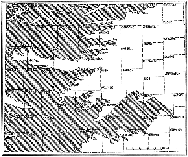
Hamilton County, comprising an area 25 miles from east to west by 36 miles from north to south, is in the third tier of counties north of the south boundary of Kansas and is adjacent to the Colorado line (Fig. 13). It is within the High Plains division of the Great Plains province, and its surface presents in general a broad, flat table-land (Fig. 14B), interrupted by the drainage channel of Arkansas river, which flows in a southeastward direction across the middle of the county, and modified to a much less marked degree by the North Fork of Bear creek, in the southern part of the county. The plains have a gentle eastward inclination, the highest parts of the county being near its west boundary. In the southwestern part the maximum altitude above sea level is slightly below 3,700 feet, and in the northwest corner the surface rises about 300 feet higher. Arkansas river has an average grade of about 8 feet to the mile across the county, and its bed is at an altitude of 3,100 feet where it crosses the east boundary.
Figure 13--Index map of Kansas showing location of Hamilton County.
Figure 14A--Water hole on the High Plains, sec. 25, T. 25 S., R.43 W., Hamilton County.
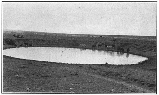
Figure 14B--View on the High Plains, sec. 26, T. 25 S., R. 41 W., Hamilton County.
Because of low annual rainfall (average 15.59 inches) and hot winds, the raising of crops is in general difficult. A small percentage of the total area is farmed with mediocre success, but the greater part is given over to the grazing of cattle. Short grasses, of which buffalo and grama are most abundant, form a dense sod that covers the surface. The observations of this one summer indicate that broom corn, wheat, and drought-resistant sorghums are the principal crops raised on the farms. A narrow irrigated strip along Arkansas river produces excellent crops, among which alfalfa hay is probably of the greatest value. The farms are thinly scattered, particularly north of the Arkansas valley, and there are but a few small towns in the county, the total population being 2,500 in 1925.
Figure 15--Outcrop of volcanic ash in sec. 13, T. 26 S., R. 41 W., Hamilton County.
The main line of the Atchison, Topeka & Santa Fe railway crosses the county and Syracuse is a division point, where a hotel and small shops are maintained. The Santa Fe automobile trail parallels the railroad, and a graded road crosses the county from north to south. The used roads throughout the area are for the most part not graded, but because the surface is exceedingly level and is underlain by materials that form an excellent natural road bed, and the rainfall is low, they are in fair condition throughout most of the year.
Stratigraphy
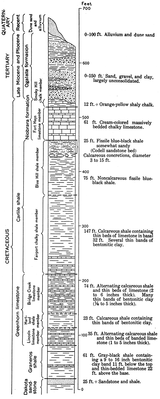
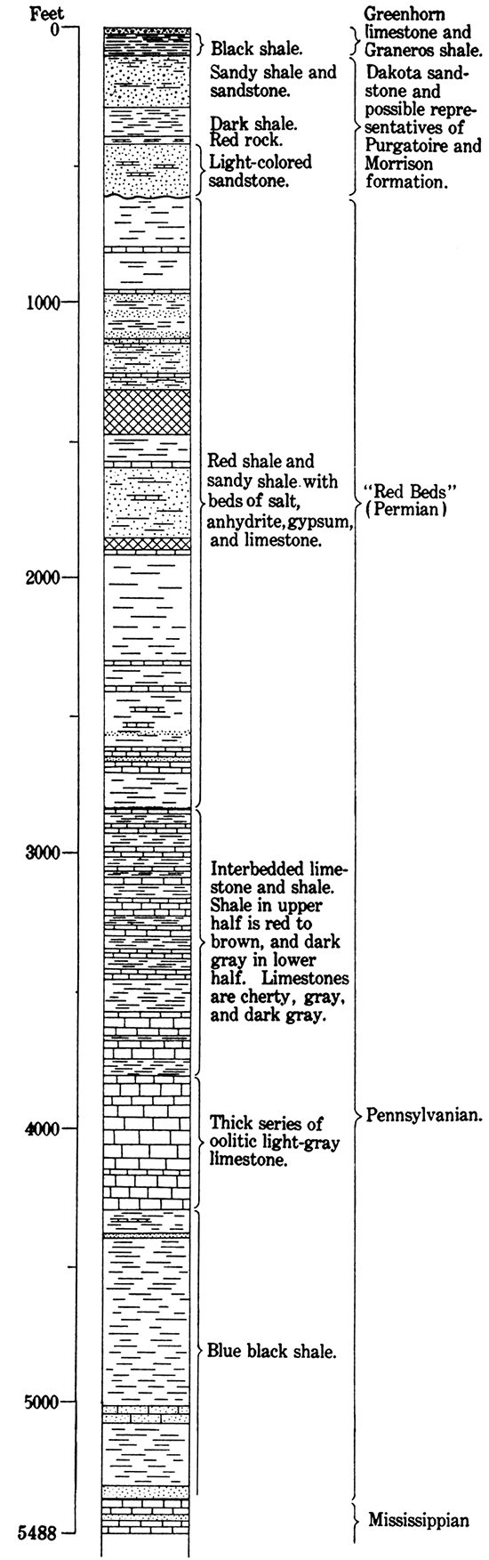
A little more than 500 feet of rocks of Cretaceous age, about 150 feet of Tertiary sediments, 25 feet of Quaternary alluvium, and dune sand of an unknown thickness are exposed in Hamilton County (Fig. 16), and nearly 5,000 feet of older rocks have been penetrated by the drill. Except in a few scattered localities (see Pl. V) the Cretaceous rocks are effectively concealed by a mantle of Tertiary and Quaternary deposits spread over their eroded edges. A generalized section of the rock formations is given below.
Figure 16--Columnar section of rocks exposed in and near Hamilton County, Kansas.
| Stratigraphic section in Hamilton County, Kansas | ||||
|---|---|---|---|---|
| Age | Formation | Member | Lithologic character | Thickness (feet) |
| Recent | Alluvium along Arkansas river and other streams. Dune sand. | 0-100+ | ||
| Pleistocene (?) | Volcanic ash in southern part of county. | 0-2 1/2 | ||
| Pliocene and late Miocene | Ogalalla formation | Sand, clay, gravel, and "mortar beds." | 0-150 | |
| Unconformity | ||||
| Upper Cretaceous | Niobrara formation | Smoky Hill chalk member | Soft shaly chalk with limonitic concretions. Top not exposed. | 12 |
| Fort Hays limestone member | Light cream-colored thick-bedded chalky limestone containing thin partings of dark-gray chalky shale. | 61 | ||
| Carlile shale | Blue Hill shale member | Blue-black fissile shale. slightly sandy in top 25 feet (Codell sandstone bed). Contains layer of calcareous concretions just below the Codell sandstone bed. | 100 | |
| Fairport chalky shale member | Calcareous shale with thin bedded chalky limestone near base. | 147 | ||
| Greenhorn limestone | Bridge Creek limestone member | Alternating limy shale and thin chalky limestone. | 74 | |
| Hartland shale member | Limy shale. | 23 | ||
| Lincoln limestone member | Limy shale; thin-bedded. finely banded limestone; and thin chalky limestone. | 35 | ||
| Graneros shale | Gray-black fissile clay shale, with thin-bedded limestone 22 feet above base. | 61 | ||
| Lower Cretaceous (?). | Dakota sandstone and possible representatives of Lower Cretaceous Purgatoire formation and Lower Cretaceous (?) Morrison formation. | Irregularly bedded light-colored fine-grained sandstone, sandy shale, and shale in upper part; dark shales near middle; and light-tan sandstone at base. Upper 25 feet exposed. | 400+ | |
| Permian (?) | Red shale, sandy shale, anhydrite, gypsum, salt, and a little limestone. | 2,200+ | ||
| Pennsylvanian | Interbedded dark-gray cherty limestone and shale. Shale red and brown in upper half and dark-gray in lower half. | 1,000 | ||
| Light-gray oolitic limestone containing a few thin breaks of dark-gray shale. | 500 | |||
| Dark-gray to black shale. | 800+ | |||
Quaternary System
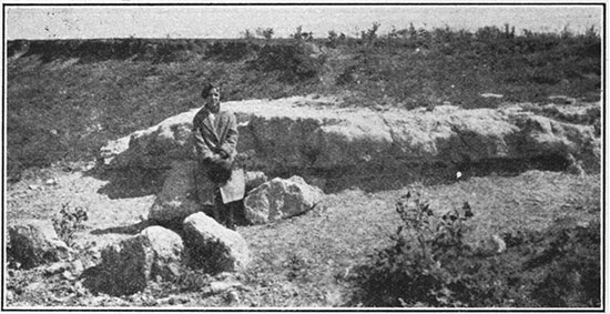
A belt of Recent alluvium averaging about 2 miles in width and about 25 feet in thickness borders Arkansas river, the greater part of it north of the present river channel. Paralleling the alluvium on the south is a belt of dune sand of unknown thickness, probably not more than 75 feet, composed largely of quartz sand. This belt is 3 to 5 miles wide. The surface of the greater part of the dune area is covered with coarse grasses such as are common to dune-sand regions of the West, but there are considerable areas of bare dunes that shift their positions with every wind storm. Beds of volcanic ash as much as 2 1/2 feet thick, of Pleistocene (?) age, occur in southern Hamilton County (Fig. 15).
Tertiary System
Ogalalla Formation
The Ogalalla formation, which has a maximum thickness of 150 feet and consists of lenses of gravel, sand and clay intricately overlapping one another, all unconsolidated except for a few layers cemented with lime carbonate, occupies the greater part of the surface of Hamilton County. It was spread upon, the eroded floor of Cretaceous rocks by aggrading streams of Pliocene and late Miocene time (Darton, 1920a). The greatest amount of the material in the formation is unconsolidated sand of a reddish-brown color. Numerous thick lenses of dark clay and muck are reported in the logs of drilled water wells, and thin layers of gravel are common. Here and there are layers of sand and gravel that are cemented by abundant lime. carbonate into a comparatively hard rock having much the appearance of old mortar and commonly known as "mortar beds" (Hay, 1895). The ridge south of Coolidge and Medway, constituting the divide between Arkansas river and the North Fork of Bear creek, is capped by "mortar beds." The gravel beds and coarse sands of the formation carry water throughout much of western Kansas and are consequently the main source of well-water supply over a wide area.
Cretaceous System
Niobrara Formation
Smoky Hill chalk member. An unknown thickness of the lower part of the Smoky Hill chalk member of the Niobrara formation unconformably underlies the Tertiary rocks in the northern part of Hamilton County. The basal 12 feet of the member, which consists of orange-yellow soft shaly chalk, is exposed in the NW, sec. 3, T. 22 S., R. 43 W., and a thin remnant of the basal beds shows in the creek bank in sec. 14, T. 22 S., R. 42 W. These rocks contain numerous flat circular limonitic concretions and many flat circular shells of the bivalve Inoceramus (Haploscapha) grandis Conrad, plastered with oyster shells. The limonitic concretions fill casts of specimens of the Inoceramus shells. Numerous partly replaced shells were seen in the Smoky Hill chalk member in Ellis and Trego counties, which lie east of Hamilton County.
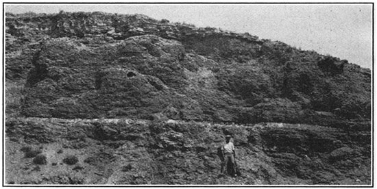
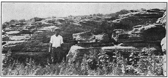
Fort Hays limestone member. A thickness of 61 feet of cream-colored chalky limestone, in massive beds ranging from a few inches to 3 1/2 feet in thickness, separated by thin layers of dark-gray clay shale, constitutes the Fort Hays limestone member of the Niobrara formation (Fig. 17). In this respect the member maintains in remarkable degree the characteristics exhibited in Ellis County and neighboring parts of central western Kansas, where it is so extensively exposed. The shale bands are more numerous and the limestone beds appear to be slightly softer and chalkier in Hamilton County than in the areas to the east, although these characteristics may be due to the more recent exposure of the outcrops seen in Hamilton County. Practically the entire member contains in fair abundance specimens of the coarse-ribbed, rounded shells of Inoceramus deformis, and associated with them are shells of Ostrea congesta. The topmost few feet of the member is more shaly than the remainder. These top beds form a rather distinct bench, however, and in the few exposures seen are whiter and harder than the overlying beds, and they do not contain the flat circular limonitic concretions and flat Inoceramus (Haploscapha) grandis shells so common in the Smoky Hill member.
Figure 17--The upper 15 to 20 feet of the Fort Hays limestone member of the Niobrara formation, sec. 3, T. 22 S., R.. 43 W., Hamilton County. View southeastward.
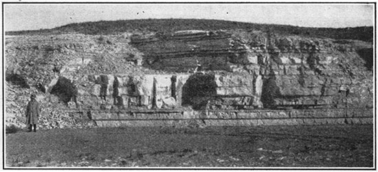
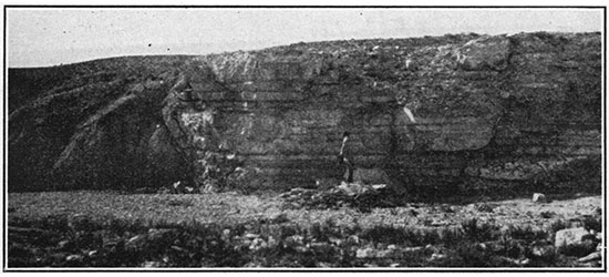
Figure 18--Fault in sec. 29, T. 22 S., R. 42 W., Hamilton County. Beds of the Fort Hays limestone member of the Niobrara formation show on the right side of the main fault and the topmost 25 feet (Codell sandstone bed) of the Blue Hill shale member of the Carlile shale are on the south. A second fault having a small throw shows near the right end of the picture. View westward.
The base of the member is quite sharply defined from the underlying Carlile shale. The contact is in many places marked by a hard, dark blue gray, fossiliferous limestone only a few inches thick that emits a strong odor of petroleum when broken. Individual beds in the member are difficultly traceable, but a series of limestone beds can be correlated readily from one exposure to another.
Exposures of the Fort Hays limestone member are limited to the northwest part of the county, where tributaries of Arkansas river cutting headward have laid bare in their steep walls limited areas of these beds underlying the Tertiary deposits. It is probable that exposures other than those shown in Plate I exist in the gulches in the south part of T. 22 S., R. 42 W., for this area was not visited.
Fossils from the Fort Hays limestone from bluff of the limestone on Bridge creek in sec. 25, T. 22 S., R 42 W., were identified by J. B. Reeside, Jr., of the United States Geological Survey, lot 12793. The only species identified was Inoceramus deformis Meek.
Carlile Shale
A body of shale that is noncalcareous, blue black and fissile in its upper 100 feet and limy and lighter colored, increasingly so downward, in its lower part, the whole comprising a total thickness of about 250 feet (based in part on the log of a water well) constitutes the Carlile shale. It was divided into two members in Russell County, the Blue Hill shale member above and the Fairport chalky shale member below (Rubey and Bass, 1925, p. 33). These subdivisions are readily determinable in the outcrops in Hamilton County, for in general they maintain here the characteristics exhibited in Russell County, nearly 150 miles to the northeast.
Blue Hill shale member. Blue-black noncalcareous fissile clay shale; sandy in its upper part and containing a layer of calcareous concretions 25 feet below the top, constitutes the Blue Hill shale member. The uppermost 25 feet consists of gritty shale containing very thin streaks of silty sandstone, and the top 2 feet is largely sand. This sandy zone constitutes the Codell sandstone bed described in Part I. At 25 feet below the top of the member, or just beneath the Codell bed, is a layer of calcareous concretions which are commonly 4 to 5 feet in diameter, though some attain a diameter of 15 feet. These concretions crop out along many of the gulches in northwestern Hamilton County and are especially abundant on Bridge creek in the NE sec. 35 and the NW sec. 36, T. 22 S., R. 42 W., west of Brower's ranch house. Figure 19 is a view of a few of the concretions at this. locality. Many individuals exhibit a marked cone-in-cone structure in their upper weathered surfaces and contain a few septa filled with vein calcite. One concretion unusually well exposed near Brower's ranch passes laterally into a thin calcareous shaly sandstone which contains numerous casts of mud cracks on its upper surface. Below the concretions is 75 feet of blue-black fissile clay shale that is exposed in its entire thickness in sec. 29, T. 22 S., R. 42 W.
Figure 19--Calcareous concretions in the Blue Hills shale member of the Carlile shale on Brower's ranch, sec. 36, T. 22 S., R. 42 W., Hamilton County.
The Blue Hill member has thinned westward from the region of Ellis and Russell counties, where it ranges in thickness between 175 and 215 feet, to a thickness of 100 feet in Hamilton County. In Ellis and Russell counties it contains numerous layers of septarian lime concretions, but in Hamilton County it contains only one. The Codell sandstone bed is present in the uppermost part of the member but contains much more intermixed and interlaminated clay than in the areas farther east.
The fossils from the Blue Hill member, as reported by J. B. Reeside, Jr., of the United States Geological Survey, consist of the following:
| Lot 12762, NW sec. 32, T. 22 S., R. 42 W. | |
| Inoceramus sp., fragments. | |
| Prionocyclus wyomingensis Meek | |
| (upper Carlile fauna). | |
| Lot 12769, sec, 36, T. 22 S., R. 42 W.: | |
| Prionocyclus wyomingensis Meek. | |
| Lot 12770, sec. 36, T. 22 S., R. 42 W. Top of Codell sandstone bed: | |
| Ostrea congesta Conrad (float?). | |
| Ptychodus sp. | |
| Lamna? sp. | |
| Corax? sp. | |
| Coprolites and phosphate nodules. | |
| "If the idea is correct that a phosphate nodule and fish bone horizon represents a suspension of sedimentation, this horizon offers an interesting and useful place for a sedimentary boundary." | |
| Lot 12772, from very top of member, at contact with Fort Hays limestone, sec. 36, T. 22 S., R. 42 W.: | |
| Inoceramus fragilis Hall and Meek. | |
| Prionocyclus wyomingensis Meek | |
| (upper Carlile fauna). | |
Fairport chalky shale member. Calcareous blue-black shale in the upper part, becoming more limy and somewhat lighter in color downward, and thin chalky limestone beds alternating with limy shales in the basal 35 feet, the whole having a thickness of 147 feet (based on the log of a water well), make up the Fairport chalky shale member of the Carlile shale. Its contact with the overlying Blue Hill member is not sharply defined. It can be fairly definitely differentiated, however, in sec. 32, T. 22 S., R. 42 W., by the lack of calcareousness in the shale of the overlying member. Fossils collected a short distance below the contact are diagnostic of the lower Carlile. The upper three-quarters of the member is only partly exposed in the region, but on the basis of the few exposures seen and its gently sloping topographic expression it is believed to be practically all calcareous shale with a very few beds of shaly limestone 1 to 2 inches thick. The lower one-fourth of the unit contains eleven beds of light-gray generally fossiliferous chalky limestone, relatively soft on fresh exposure, averaging 3 to 4 inches in thickness, no bed exceeding 6 inches. The lower shales are very calcareous and likewise fossiliferous. Many thin layers of bentonitic clay, one-quarter to 1 inch thick, are present throughout the member, though they decrease in number upward. One layer of orange-colored bentonitic clay 8 inches thick occurs 32 feet above the base. The entire member is of a bluish color on fresh exposure and weathers to a cream-gray, becoming lighter in color downward.
The fossils from the Fairport member, as reported by J. B. Reeside, Jr., of the United States Geological Survey, are listed below. The positions of the collections in the stratigraphic section are shown in Figure 21 by numbers corresponding to the lot numbers given here.
| Lot 12785, sec. 14, T. 23 S., R. 42 W., from chalky limestone bed 18 feet above base of member: | |
| Inoceramus labiatus Schlotheim, broad variety | |
| (lower Carlile fauna). | |
| Lot 12788, sec. 7, T. 23 S., R. 42 W., from chalky limestone bed 5 feet above base of member: | |
| Inoceramus labiatus Schlotheim, broad variety | |
| (lower Carlile fauna). | |
| Lot 12814, sec. 7, T. 23 S., R. 42 W., from chalky limestone bed 16 feet above base of member: | |
| Ostrea cf. O. congesta Conrad. | |
| Inoceramus labiatus Schlotheim, broad variety. | |
| Baculites gracilis Shumard. | |
| Prionotropis woolgari (Mantell). | |
| Ichthyodectes? sp. | |
| Lot 12784, sec. 7, T. 23 S., R. 42 W., from chalky limestone bed 12 feet above base of member: | |
| Globigerina bulloides. | |
| Ostrea cf. O. congesta Conrad. | |
| Inoceramus labiatus Schlotheim, broad variety. | |
| Inoceramus fragilis Hall and Meek. | |
| Prionotropis woolgari (Mantell). | |
| Ichthyodectes? sp. | |
| (Lower Carlile fauna.) | |
| Lot 12824, sec. 14, T. 22 S., R. 42 W., from chalky limestone bed 11 feet above base of member: | |
| Globigerina bulloides D'Orbigny, | |
| Inoceramus labiatus Schlotheim, broad variety. | |
| Inoceramus fragilis Hall and Meek. | |
| Baculites sp. | |
| Prionotropis woolgari (Mantell). | |
| (Carlile fauna.) | |
Greenhorn Limestone
The Greenhorn limestone, consisting of calcareous shale interbedded with thin layers of chalky and crystalline limestone and bentonitic clay, is sharply defined from the underlying Graneros shale, but merges into the overlying Carlile shale with no apparent lithologic change. Its separation from the basal member of the Carlile shale is made on the evidence of the fossils that occur abundantly above and below the contact of the two formations. The Greenhorn limestone is 132 feet thick and is readily divisible into three members in the Hamilton County region-an upper member of alternating chalky limestone and shale, herein named Bridge Creek limestone member; a middle member of limy shale, herein named Hartland shale member; and a basal member of interbedded limy shale, chalky limestone, and thin-bedded hard crystalline limestone that represents the Lincoln limestone member of counties to the east.
Bridge Creek limestone member. Alternately bedded limy shale and chalky limestone, having a total thickness of 74 feet, four-fifths of which consists of shale, constitute the Bridge Creek limestone member of the Greenhorn limestone. These beds are excellently exposed on Bridge creek northwest of Medway, in sec. 14, T. 23 S., R. 42 W. The member as a whole is harder than the overlying and underlying beds and characteristically forms low bluffs or terraces. It is this member that forms the relatively steep slope bordering the Arkansas river bottoms on the north. (Plate V.) The chalky limestone, which constitutes scarcely one-fifth of the total thickness of the member, occurs in somewhat equally spaced beds averaging 4 inches in thickness, no single bed exceeding 10 inches. A view of a part of the member cropping out on Bridge creek is shown in Figure 20. Ten or more bands of bentonitic clay are present, ranging from a quarter of an inch to 5 inches in thickness. Although fossils are rare in the lower third of the member, they are abundant in the shale and limestone of the upper two-thirds and are much better preserved in the limestone than in the shale. The limestone beds occurring from 40 to 50 feet above the base are composed almost entirely of fossil shells of Inoceramus labiatus, a characteristic species of the Greenhorn limestone. Because the individual beds of limestone and layers of bentonitic clay of the member are so persistent laterally, a detailed section of the stratigraphic sequence of beds was measured in order that the very meager exposures of parts of. the member that occur on the flanks of the Syracuse anticline might be compared with this section and properly allocated in the stratigraphic column. Figure 21 shows a detailed section of the Bridge Creek limestone member and the lower part of the overlying Fairport chalky shale member. The limestones of the Bridge Creek member terminate abruptly at the base in a relatively thick bed split near the middle by a thin bed of shale. The double limestone bed thus formed, because of its superior hardness over the underlying soft shale, forms a bench that terminates below in a steep slope and rises more gradually to a series of very minor terraces formed by the several limestone layers above. A thick layer of bentonitic clay (Fig. 21) that occurs above the basal limestone weathers into an ocherous clay soil spread upon the lowest terrace, and the white chips of the basal limestone lie immediately below it and form the cap to the steep slope of the succeeding Hartland shale member. These characteristics are excellently shown in the low bluff paralleling Arkansas river on its north side from Kendall southeastward for several miles in western Kearny County.
Figure 20--A part of the Bridge Creek limestone member of the Greenhorn limestone, in the east bank of Bridge creek, sec. 14, T. 23 S., R. 42 W., Hamilton County. The abundantly fossiliferous limestone beds of the member occur near the top of the exposure.
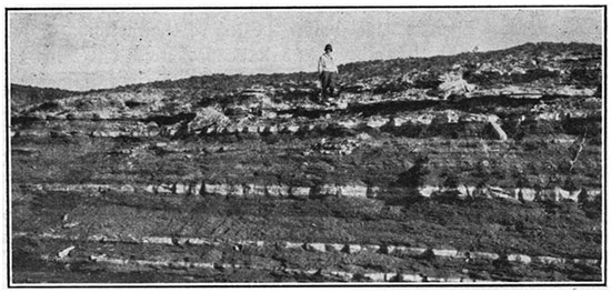
Figure 21--Graphic detailed section of the lower part of the Fairport member, and the Bridge Creek member of the Greenhorn limestone.
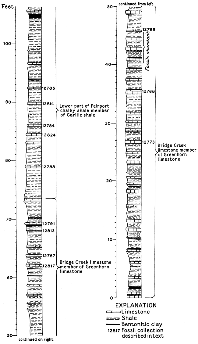
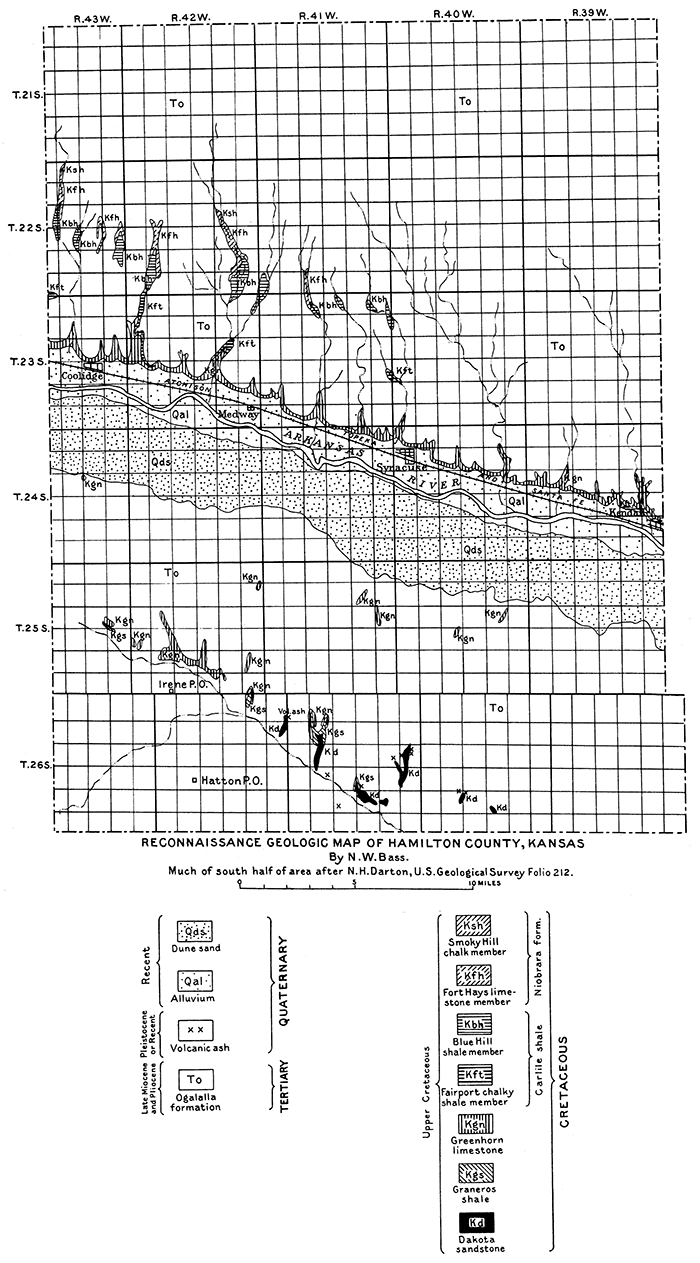
Plate V--Reconnaissance geologic map of Hamilton County, Kansas. An Acrobat PDF version of this figure is available.
The field work in Hamilton County was done after the writer had become acquainted with the Greenhorn limestone in Ellis and Russell counties in central Kansas, where the upper half of the formation is divided into the Pfeifer shale member and Jetmore chalk member. These subdivisions can be recognized in Hamilton County, although less distinctly. The uppermost 25 feet of the Bridge Creek member of Hamilton County is almost certainly the equivalent of the Pfeifer shale member of Ellis County, the topmost bed being the "fence-post limestone." The remainder of the Bridge Creek member apparently represents the Jetmore chalk member of central western Kansas. In Hamilton County, as in Russell and Ellis counties, this part of the member is capped by a relatively thick limestone bed that is slightly harder than those above it, although not conspicuously different from the others, and the limestone beds of the upper part of the member are composed almost entirely of fossil shells of Inoceramus labiatus. The top 5 feet of this member and the basal 8 feet of the overlying member are exposed in Beeler's pasture, about half a mile south of the ranch house. This occurrence is one of the few good exposures on the north flank of the Syracuse anticline and is consequently the best-known outcrop in the region. In this exposure the thick limestone bed that shows in the creek bank a little more thanS feet above a concretionary bed and forms a prominent shelf about 2 feet above the level of the creek is believed to be the equivalent of the top bed of the Jetmore member and is 49 feet above the base of the Bridge Creek member.
Hartland shale member. Below the Bridge Creek member is a unit of calcareous shale 23 feet thick that is almost devoid of limestone and contains numerous layers of bentonitic clay ranging from a quarter of an inch to 2 inches in thickness. This shale weathers to a tannish gray or flesh color. The entire unit is clearly exposed in western Kearny County, in the bluff on the north side of the old Santa Fe trail, from a point a short distance west of Hartland to Kendall, where the member forms a slope between a cap of white chips formed by the basal limestone beds of the Bridge Creek limestone and a lower bench made by the thin, hard layers in the upper part of the Lincoln limestone member. A section measured in Kearny County, about half way between Sutton and Kendall, shows the Hartland member to be composed of calcareous shale with very thin layers of bentonitic clay at intervals of 8 inches, 2 feet 6 inches, 2 feet 10 inches, 6 feet 6 inches, 7 feet 3 inches, 10 feet 6 inches, 11 feet 4 inches, 15 feet 6 inches, 16 feet, and 17 feet above the base, and four thin layers of ocherous clay in the top 1 1/2 feet of the member. A few lenses of very dark gray fossiliferous limestone a quarter of an inch to 1 inch thick occur in the member.
The Hartland shale member is lithologically similar to the unnamed member between the Jetmore and Lincoln limestone members of the Greenhorn limestone in Russell County," and occurs in the same stratigraphic position (Rubey and Bass, 1925, p. 47).
Lincoln limestone member. The basal 35 feet of the Greenhorn limestone is also predominantly calcareous shale, and only about one-tenth of its thickness is made up of beds of limestone, which occur in thin layers half an inch to 4 inches thick, averaging about 2 inches. These limestone beds are hard, finely banded, and in part crystalline, have a dark-gray color but weather brown, and are present in most abundance near the base and top of the member. They typically weather into hard, banded, brownish slabs that emit a petroliferous odor on fresh fracture. The unit as a whole. although of bluish color on fresh exposure, weathers to a much darker tan or orange-tan color than other members of the Greenhorn. Its lower beds are well exposed in the railroad cut 1 mile east of Sutton siding, in western Kearny County, and the beds of its upper part crop out 2 miles east of Kendall, on the north side of the road. This series of beds corresponds so closely in lithology and stratigraphic position to the Lincoln limestone member of the Greenhorn limestone of Lincoln and Russell counties that, although it is impossible to trace the beds throughout most of the intervening area, because of the overlap of Tertiary sediments, little hesitancy is felt as to their correlation. Its dominant characteristics-hard, finely banded, thin-bedded crystalline limestone at the top and base, with chalky shale and soft chalky limestones constituting the mass of the unit are alike in each region.
Fossils. The fossils from the Greenhorn limestone, as reported by J. B. Reeside, Jr., of the United States Geological Survey, are listed below. The stratigraphic position of the collections from the Bridge Creek limestone member are shown in Figure 21 by numbers corresponding to the lot numbers given here:
| Lot 12761, near quarter corner between secs. 27 and 28, T. 25 S., R. 42 W., from Bridge Creek limestone member: | |
| Inoceramus labiatus Schlotheim. | |
| (Greenhorn fauna.) | |
| Lot 12768, SW sec. 14, T. 23 S., R. 42 W., from limestone bed 36 feet above base of Bridge Creek limestone member: | |
| Inoceramus labiatus Schlotheim. | |
| Baculites? sp. | |
| Puzosia n. sp., identical with species found in the NW sec. 12, T. 14 S., R. 13 W., Russell County, and related to a species in the lower Carlile of the Black Hills. | |
| (Greenhorn fauna.) | |
| Lot 12773, SW sec. 14, T. 23 S., R. 42 W., from limestone bed 27 feet above base of Bridge Creek limestone member: | |
| Inoceramus labiatus Schlotheim. | |
| Thomasites n. sp., a genus reported once previously in North America from the Greenhorn of the Front Range in Colorado. It is known in the lower Turonian of southern Europe and Africa. | |
| (Greenhorn fauna.) | |
| Lot 12787, sec. 14, T. 23 S., R. 42 W., from limestone bed 9 feet below top of Bridge Creek limestone member: | |
| Inoceramus labiatus Schlotheim, broader than typical form, though it does not seem to be the broad variety. | |
| Lot 12791, sec. 7, T. 23 S., R. 42 W., from limestone bed 4 feet below top of Bridge Creek limestone member: | |
| Prionotropist n. sp., same as specimen from locality 12540, in Ellis County, and probably same as one from Huerfano Park, Colo. | |
| Lots 12817 and 12822, sec. 14, T. 23 S., R. 42 W., from limestone bed 11 feet below top of Bridge Creek limestone member: | |
| Ostrea cf. O. congesta Conrad. | |
| Inoceramus labiatus Schlotheim. | |
| Textularia sp. | |
| Globigerina bulloides D'Orbigny. | |
| Inoceramus labiatus Schlotheim. | |
| (Greenhorn fauna.) | |
| Lot 12760, NE, sec. 32, T. 24 S., R. 38 W., about 2 miles southeast of Kendall, Kearny County, from bed near top of Lincoln limestone member: | |
| Globigerina bulloides D'Orbigny. | |
| Inoceramus labiatus Schlotheim. | |
| (Greenhorn fauna.) | |
| Lot 12765, sec. 2, T. 25 S., R.. 38 W., half a mile east of Sutton siding, Kearny County, from bed near base of Lincoln limestone member: | |
| Inoceramus labiatus Schlotheim. | |
| Echidnocepthalus? sp. | |
| (Greenhorn fauna.) | |
Graneros Shale
Gray-black fissile argillaceous shale, sharply separated at the top from the banded limestone slabs of the basal (Lincoln) member of the Greenhorn limestone and less sharply separated at the base from the underlying Dakota sandstone, with a thickness of 60 to 65 feet, constitutes the Graneros shale. At 10 feet below its top is a prominent and persistent bed of bentonitic clay that ranges from 5 to 16 inches in thickness. The upper half of the formation is well exposed in the railroad cut a mile east of Sutton siding, in western Kearny County. (Fig. 22.) At 20 to 22 feet above the base of the formation a zone 5 to 6 feet thick contains thin-bedded fossiliferous sandy limestones that weather to a rusty-colored rough surface. These beds crop out in the irrigation canal a mile west of Hartland, Kearny County, just west of the ditch crossing of the old Santa Fe trail. They crop out also in the NW, sec. 8, T. 26 S., R. 41 W., 1 1/4 miles south of the Wood Oil Co.'s well. A log of a water well drilled by the Atchison, Topeka & Santa Fe Railway Co. at Coolidge shows limestone 1 foot thick at this horizon. The basal 8 or 10 feet of the formation characteristically contains lenses of impure sandstone and sandy shale and layers of iron concretions 2 to 8 inches in diameter, constituting transition beds from the underlying Dakota sandstone. The basal beds of the Graneros are exposed in the SW, sec. 22, and the SW, sec. 8, T. 26 S., R. 41 W.
Figure 22--Graneros shale capped by basal beds of Lincoln limestone member of Greenhorn limestone in cut bank on north side of Arkansas river, 1lf2 miles east of Sutton Siding, Kearny County. Bentonitic clay band 9 inches thick a few feet above man's head.
The fossils, as reported by J. B. Reeside, Jr., of the United States Geological Survey, consist of the following:
| Lot 12764, sec. 2, T. 25 S., R. 38 W., three-quarters of a mile east of Sutton siding, Kearny County: | |
| Ostrea n. sp., small single type, found at several localities in the Graneros of Kansas. | |
| Lot 12767, SE, sec. 7, T. 25 S., R. 37 W., 3 miles southeast of Sutton. siding, Kearny County: | |
| Ostrea n. sp. small single type found at several localities in the Graneros of Kansas. | |
| Inoceramus n. sp. (?) related to I. fragilis Hall and Meek. | |
Dakota Sandstone
The upper 25 to 30 feet of the Dakota sandstone consists of light. tan or buff fine-grained irregularly bedded sandstone and shale, and crops out in several small areas in southern Hamilton County. The topmost beds, which grade into the overlying Graneros shale, are commonly very ferruginous, very fine-grained, and in places crossbedded, and layer upon layer are strongly ripple marked. The sandstone lenses interfinger with the shale (Fig. 23). In places the top sandstone of the formation is a relatively massive bed about 3 feet thick, which weathers into large blocks and is composed of very fine-grained quartz sand, the whole presenting a light tan color. Commonly above this are thin-bedded ironstone layers embedded in the basal part of the Graneros shale, or very ferruginous sandstone or ironstone concretions. In other exposures irregularly crossbedded, poorly sorted rusty-brown sandstone and dark-gray to light shale aggregating 10 feet in thickness overlie this massive bed (Fig. 24).
Figure 23--Cross-bedded sandstone interfingering with shale and overlying massive sandstone bed near the top of the Dakota sandstone. Sec. 27, T. 26 S., R. 41 W., Hamilton County.
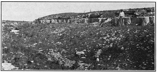
Figure 24--Cross-bedding in the upper part of the Dakota sandstone. Sec. 17, T. 26 S., R. 41 W., Hamilton County. View southwestward.
South of Hamilton County, in Stanton and Morton counties and near Hartland in Kearny County, parts of the Dakota sandstone have been recemented with silica to form steel-gray dense quartzite that weathers brown and dark gray. In many exposures this rock occurs in rudely spherical or concretionary forms that weather out on the surface. In other exposures gradations from sandstone to quartzite are exposed. Because of their superior hardness these quartzite masses cap many rounded knolls in the area of their outcrop. The quartzite boulders are often encountered in drilling water wells in the region, and great difficulty is experienced in drilling through them. The Dakota sandstone carries an abundant supply of water, and it furnishes most of the stock water for the ranches of southern Hamilton County and supplies the flowing wells in the vicinity of Coolidge. It is reported that a few water wells penetrated thin coal beds near the top of the formation.
Rocks penetrated by the Wood Oil Co.'s well. The unusually deep test well o(the Wood Oil Co. in the northwest corner of sec. 5, T. 26 S., R. 41 W., affords some information regarding the beds below the Dakota sandstone in Hamilton County. This well starts 105 feet above the top of the Dakota sandstone. The rocks between depths of 105 and 612 feet as recorded in the log are principally light-colored sandstones and shales, which carry considerable water (Fig. 25). From 105 to 290 feet is sandy shale and sandstone; from 290 to 400 feet is shale, below which is 30 feet of red rock and pink limestone underlain by 180 feet of sandstone with 50 feet of sandy limestone near the top. It cannot be determined from the log how much of this is in the Dakota sandstone and how much represents older strata. Darton suggests that the lower parts of this sandy unit may include representatives of the Lower Cretaceous Purgatoire formation and the underlying Lower Cretaceous (?) Morrison formation (Darton, 1920a). Between the depths of 612 and 2,832 feet the well penetrated a series of red shales and sandstones with a few layers of anhydrite and gypsum; about 100 feet of salt which occurs principally in two beds; and some limestone, most of which is in the lower part. The greater part of these rocks is probably of Permian age, although the lower beds may be Pennsylvanian. For a thousand feet below this red series are limestones and shales. The shales are brown to red-brown in the upper half and become dark gray to black below. The limestones are gray, are very commonly cherty, and contain microscopic fossils of Pennsylvanian age at several horizons. About 450 feet. of dark gray oolitic limestone that contains a few thin breaks of shale occurs beneath this group. Although long-range well-log correlations are likely to be in error, the great thickness of oolitic limestone underlying a series of alternating limestone and shale appears from a study of logs of wells scattered throughout Kansas to correspond in general to a thick series of limestone occurring above the Cherokee shale in the eastern part of the state. From 4,300 feet to 5,350 feet the drill passed through dense blue-black shale that contains a few thin breaks of limestone, mostly in the upper part; a very fine sandy shale between 4,370 and 4,390 feet; and fine sharp sand in the lowermost 50 feet. This thick shale series occupies the stratigraphic position of the Cherokee shale of eastern Kansas. At a depth of 5,350 feet gray cherty limestone of probable Mississippian age was struck, and the hole was continued in limestone and sand to a depth of 5,488 feet, where it was abandoned.
Figure 25--Generalized stratigraphic section of buried rocks of Hamilton County, Kansas, as shown in log of well drilled in sec. 5, T. 26 S, R. 41 W.
Brief Geologic History, with Special Reference to Structural Mapping
Long before the deposition of the Tertiary rocks that now occupy the greater part of the surface of Hamilton County (Plate V) the underlying stratified beds were arched or gently folded into the Syracuse anticline and for a long period of time were eroded by streams. Probably thousands of feet of sediments were removed, until on the top of the Syracuse anticline only the Graneros shale and the lower part of the Greenhorn limestone remained, and on the southeast slope of the anticline streams had removed these rocks also and had cut into the underlying Dakota sandstone. Then the Tertiary sand, gravel, and clay of the Ogalalla formation were spread out over the folded beds by streams heavily laden with debris from the recently formed highlands to the west, in Colorado. These aggrading streams of late Tertiary (Miocene and Pliocene) time continued building until the old stream channels were deeply buried and a gently inclined, almost plane surface (Fig. 14B), high above the old valleys and covering also the old. divides, occupied an extensive area east of the mountain front reaching from the Dakotas into Texas. Later, as a result of climate change, erosion again set in and has continued to the present time (Johnson, W. D., 1901). At a few localities in Hamilton County it has progressed so far as to lay bare the rocks underlying the Tertiary beds, revealing in part their structure.
This brief geologic history of the region will make it apparent to the layman as well as to one trained in the science of geology that the features of geologic structure--that is, irregularities in the position of the strata such as anticlines, synclines, and domes--cannot be determined by observations taken in this locality in the rocks of Tertiary age. It is only in those areas where the older rocks are exposed at the surface that the geologist can make observations to determine the inclination of the beds.
Because so much of western Kansas is thoroughly mantled by sand, gravel and clay of Tertiary age, it is important that the residents of the region should know that structural geologic mapping from observations of surface outcropping rocks is impossible in such areas. The state geologist is frequently asked by residents of this part of the state to confirm reports of "geologists" or others that structural features favorable for the accumulation of oil exist on their ranches. It is regrettable that ignorant or unscrupulous men posing as "oil finders" are not rare, and that they frequently mislead unwary citizens to make investments that have small chance of any return. In the hope of curtailing in part the operations of those engaged in this unworthy enterprise Figure 26 is presented, showing the general areas in western Kansas which are mantled by these Tertiary deposits and for which structure contour maps, unless based on data from a series of deep water wells or test borings that go down to a readily recognizable stratum older than the Tertiary, are not worth the paper upon which they are shown.
Figure 26--Map of western Kansas, showing areas covered by Tertiary rocks. (After Haworth.)
Structure
Folding
The accompanying sketch map (Plate VI) is drawn on the basis of the meager data afforded by the few outcrops of Cretaceous rocks, together with information supplied by the local ranchers as to depths to the Dakota sandstone in water wells. Most of the well records were given from memory. The ownership of many wells has changed, and the only available records are those handed down by memory from one owner or his neighbor to another. Plane table and telescopic alidade control was used only for the few outcrops near the Syracuse anticline. Altitudes of the water wells were obtained from the topographic map of the Syracuse quadrangle. The altitudes indicated for the outcrops in the northern part of Hamilton County were taken from aneroid readings. Because of the scarcity of data available from surface rock exposures the map compiled from the field survey may not show all the structural features in this area, and even of the known anticlinal folds it is not possible to determine certain details from surface evidence. Therefore, any more drilling for oil and gas in the area should be preceded by the drilling of several shallow wells to the Dakota sandstone to determine structural details. The axis of the main anticline is thought to trend southeastward, as shown on Plate VI, with a "high" centering in the SW, sec. 6, T. 26 S., R. 41 W., where the top of the Dakota sandstone is believed to be slightly more than 3,400 feet above sea level. It is very probable that a saddle trending northwestward crosses the fold near the northwest corner of sec. 2, T. 26 S., R. 42 W., thus forming a closure of approximately 50 feet on the west side of the dome. Prior to the drilling of other tests for oil on the "high" in the SW, sec. 6, however, a well should be drilled to the Dakota sandstone in the SE, sec. 36, T. 25 S., R. 42 W., and perhaps a second one in the section adjacent on the east, to determine if the saddle and consequently the closure on the west actually exist.
Plate VI--Sketch map showing geologic structure of southern part of Hamilton County, Kansas. An Acrobat PDF version of this figure is available.
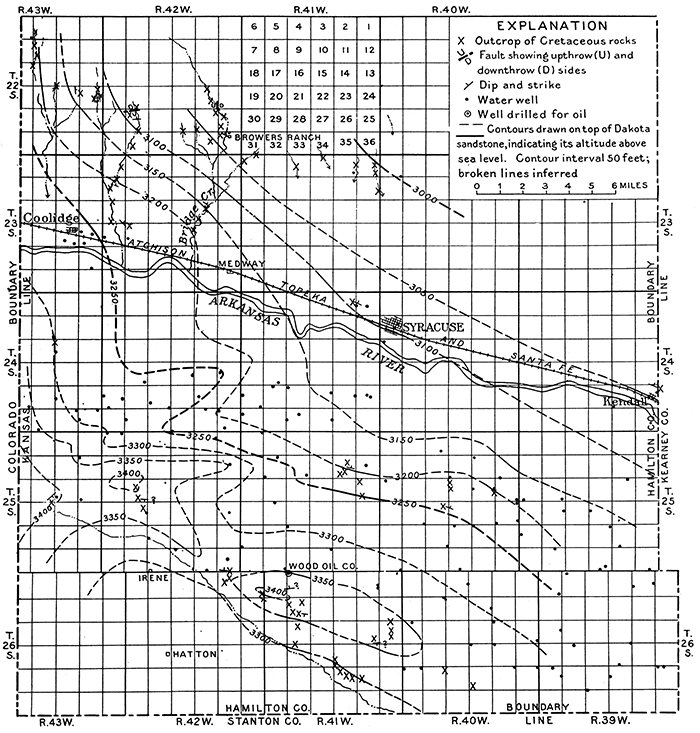
The intersection of an eastward-trending nose with the main anticline indicates a possible "high" about the common corner of secs. 7, 8, 17 and 18, T. 25 S., R. 42 W. There may be a slight dome near the quarter corner common to secs. 1 and 2, T. 25 S., R. 43 W., where a northeastward-trending nose intersects with the Syracuse fold. These two domes are indicated merely by scattered and somewhat conflicting records of water wells and should be regarded as only possible "highs." They should not be tested for oil or gas unless first accurately defined by shallow drilling to the Dakota sandstone.
The well drilled in the northwest corner of sec. 5, T. 26 S., R. 41 W., is on the northeast flank of the fold, according to the interpretation of the structure presented on Plate VI. The well was abandoned at a depth of 5,488 feet, having encountered no encouraging shows of oil and only a little gas. The strata penetrated by the drill below the red beds contain no rocks laid down near shore but appear to represent limestone and mud originating far from the shore line. Practically no sand was found in this entire series, except a little exceedingly fine-grained sand at a depth of 4,370 feet. It is generally believed that the greatest abundance of oil-forming organisms live and accumulate in mud not far off shore in marine waters. Here, too, deposits of porous sand are laid down alternately with the mud, later to serve as reservoirs for the oil. These conditions appear not to have prevailed in the region of Hamilton County for any lengthy period within Pennsylvanian time. Consequently both a source for the oil and reservoir rocks to contain it are lacking to a depth of a little more than 5,000 feet.
If other test holes are to be drilled, however, it is recommended, that the area be first covered by a sufficient number of shallow drill holes to determine accurately the local structural conditions. Because the Wood Oil Co.'s well has shown that anyone contemplating a test boring should be prepared to go more than 5,000 feet deep to test all the Pennsylvanian rocks and even deeper to penetrate underlying beds, the preliminary expense of shallow drilling does not appear unwise in this area, where any structural interpretation of the meager data available at the surface will of necessity contain many errors and may even misinterpret the main features.
Joints and Faults
In the exposures in the southern part of T. 22 S., R. 42 W., and the northwestern part of T. 22 S., R. 43 W., the Fort Hays limestone member of the Niobrara formation contains well-developed joints, the most pronounced of which in the eastern-most exposures trend in general a few degrees south of east and in the western-most exposure a few degrees north of east. The western exposures show also a second set of joints, much less strongly developed, trending N. 10° to 14° W. No definite set of secondary joints was noted in the eastern exposures, although a few trending in general about N. 35° E. were seen.
In the NE NW, sec. 29, T. 22 S., R. 42 W., the basal beds of the Fort Hays limestone are faulted into contact with the upper part of the Carlile shale. The fault plane is clearly defined. where it appears in the west bank of the creek (Fig. 18) and can be traced westward by the outcrop of slickensided calcite vein material that fills the fracture for 350 feet to a point where it goes under cover of the soil. The fault plane trends N. 85° E. and dips 72° N. The rocks are dropped on the north, the amount of throw being about 35 feet. About 25 feet farther north is a second fault with a displacement of 2 1/2 feet, in which the beds are dropped on the south, and the fault plane dips 55°. A fault in the Fort Hays limestone member that appears in the creek bank in the SE, sec. 23, T. 22 S., R. 42 W., trends N. 10° W., has a throw of 15 feet 8 inches, and drops the beds on the east. The dip of the fault plane is 55° NE. The rocks on the upthrown side 50 feet southwest of the fault plane dip about 1° W., and within 10 to 15 feet of the fault plane they flatten and may be very slightly inclined toward the fault.
A small exposure of thin-bedded hard limestone and soft shale of the Lincoln member of the Greenhorn limestone near the east quarter corner of sec. 14, T. 25 S., R. 40 W., shows a fault trending N. 75° E. The fault plane, which. is marked by a calcite vein 2 inches thick dips 60° SE., and the rocks are dropped on the southeast 1 1/2 feet. The thin-bedded limestone and shale that occupy a horizontal distance of 3 to 4 feet north of the fault plane on the upthrown side are strongly crumpled into a series of minor anticlinal and synclinal folds.
Economic Products
Sand and gravel for concrete construction occur in abundance in the alluvium along Arkansas river and in the Ogalalla formation at many places throughout the county. Material for the manufacture of cement is abundant in the area occupied by the Greenhorn limestone bordering the river flood plain on the north (Pl. V) and in the northwestern part of the county in the area of outcrop of the Fort Hays limestone. On Bridge creek in the southwestern part of T. 22 S., R. 42 W., 25 to 30 feet of the Fort Hays limestone underlain by a great thickness of shale is exposed. Stone for building has been quarried in years past from the massive sandstone beds of the Dakota in the southwestern part of the county, in secs. 22 and 27, T. 26 S., R. 41 W., and sec. 27, T. 26 S., R. 40 W. Many buildings in Coolidge, Syracuse, and Kendall are constructed from stone quarried from the Bridge Creek member of the Greenhorn limestone at localities 1 to 2 miles northwest of Syracuse, immediately north and northeast of Coolidge, and a mile northeast of Kendall. Several ranch buildings have been built from rock quarried from the Fort Hays limestone. The principal quarries are on Bridge creek in the southwestern part of T. 22 S., R. 42 W.
Volcanic ash of value as cleaning powder was noted at several localities in the county. A bed 1 1/2 feet thick occurs near the east quarter corner of sec. 20, T. 26 S., R. 41 W. It is at least 1 1/2 feet thick in the SW SW, sec. 22, and 2 1/2 feet thick near the center of sec. 13, T. 26 S., R. 41 W., where it is extensively exposed (Fig. 15). Other exposures occur in the SE SE, sec. 1, T. 26 S., R. 42 W.; the SW, sec. 28, and SE, sec. 14, T. 26 S., R. 41 W.; and the NE, sec. 29, T. 26 S., R. 40 W.
Well water of excellent quality and in great abundance is to be had throughout the south half of the county by drilling into the Dakota sandstone. Artesian water is obtained from sandstones in the Dakota near Coolidge, and the water rises high in the wells in other parts of the area. Good water at shallow depth is obtained in the alluvium and dune-sand area bordering Arkansas river, and an abundance of water occurs in the sand and gravel deposits of the Ogalalla formation in the northern part of the county. Wells drilled in the shale areas north of the Arkansas and in the western part of the county have found no water in the shale series more than 400 feet thick that lies between the Fort Hays limestone member of the Niobrara formation and the Dakota sandstone, except in the sandy zone at the top of the shale and immediately below the Fort Hays. Live springs occur in the gulches where this sandy unit crops out in secs. 25 and 29, T. 22 S., R. 42 W., sec. 24, T. 22 S., R. 43 W., and elsewhere in this vicinity. Wells located immediately below this sandy zone will have to be drilled to a depth greater than 400 feet to reach the Dakota sandstone and an abundant supply of water. The record of J. Behrendt's well, in the SE, sec. 4, T. 22 S., R. 43 W., as furnished by the driller, P. A. Bauer, indicates the thickness of the shales that are barren of water.
| Record of Behrendt well, sec. 4, T. 22 S., R. 43 W. | Thickness (feet) |
Depth (feet) |
|---|---|---|
| Rock | 5 | 5 |
| White clay (Fort Hays limestone) | 35 | 40 |
| Black shale barren of water (Carlile, Greenhorn and Graneros) | 440 | 480 |
| Dakota sandstone, water bearing | 36 | 516 |
Temperature Readings in the Wood Oil Co.'s Well
During the first week in April, 1925, the writer took the following temperature readings in the well drilled by the Wood Oil Co. in sec. 5, T. 26 S., R. 41 W. The well had at that time reached a depth of 4,650 feet. Water stood in the hole within 2,000 feet of the surface. Three maximum mercury thermometers were used. They were incased in a water-tight steel tube for readings taken in water and a perforated brass tube for readings taken above the water level. The tube containing the thermometer was set in a notch in a wooden block, and this in turn was attached to the bailer, which was lowered and raised as slowly as the well machinery would run smoothly. The thermometers were allowed to remain 3 hours for each reading made in the water and 1 1/2 hours for each reading above the water surface.
| Temperature readings in Wood Oil Co.'s well. [Altitude of surface, 3,460 feet; total depth of well at date of reading, 4,650 feet; mean annual temperature, 53.8° Fahrenheit.) |
|
|---|---|
| Depth (feet) | Temperature (deg. F.) |
| 100* | 58.1 |
| 58.1 | |
| 57.9 | |
| 500 | 63.1 |
| 63.1 | |
| 63.0 | |
| 1,000 | 66.1 |
| 66.1 | |
| 66.0 | |
| 1,500 | 75.1 |
| 75.1 | |
| †75.2 | |
| 2,000 | 79.0 |
| 79.0 | |
| ‡79.0 | |
| 2,500 | 88.7 |
| 88.8 | |
| 88.7 | |
| 3,000 | 95.7 |
| 95.7 | |
| 95.7 | |
| 3,500 | 103.9 |
| 103.9 | |
| 103.8 | |
| 4,000 | 111.7 |
| 111.7 | |
| 111.8 | |
| 4,600 | 123.1 |
| 123.1 | |
| 123.2 | |
|
* Temperature at derrick floor 50°. Thermometers were chilled in ice water and the mercury was lowered to 43° before test was made † In air. ‡ In water. |
|
These data show a lower rate of increase in temperature than the average for Kansas. Darton" states that in southeastern Kansas the average rate of increase of temperature with depth in seven wells tested is 1° in slightly less than 60 feet, and the average rate in four wells in the western part of the state is 1° in 49 feet (Darton, 1920b). The average rate of increase in the Wood Oil Co.'s well is 1° in about 69 1/2 feet.
Prev Page--Ellis County || Next Page--Dakota Sandstone
Kansas Geological Survey, Geology
Placed on web July 2, 2015; originally published April 1926.
Comments to webadmin@kgs.ku.edu
The URL for this page is http://www.kgs.ku.edu/Publications/Bulletins/11/03_hamilton.html