![]()
Prev Page--Contents || Next Page--Hamilton County
Part I--The Geology of Ellis County, Kansas
Field Work
The field work on which the report on Ellis County is based was done between the first of July and the middle of August, 1924. Inasmuch as the details of much of the stratigraphic section below the Niobrara formation exposed in Ellis County are similar to those in the area adjacent on the east, which was known to the writer from his work there with W. W. Rubey in the spring of 1924, the necessity for a great number of detailed geologic sections of these rocks in Ellis County was eliminated. Many sections of parts of the Niobrara formation were measured, however, in order to determine whether persistent recognizable units are present. The area was traversed by automobile, driven along section-line roads, and although all the lines are not open the county was covered with a fair degree of thoroughness. In this traverse the boundaries of the several formations and members and other key beds were sketched throughout the county, the topographic maps of the United States Geological Survey being used as a base.
Acknowledgments
During the field investigation county officers and other residents of Ellis County gave all possible assistance in supplying records of water wells and other information. The writer is indebted to C. J. Helms, of Ellis, for records of a large number of water wells drilled in Ellis County and elsewhere in western Kansas; and to J. F. Kinkel, geologist of the Keys Petroleum Co., for core-drill records and stratigraphic information on the Niobrara formation in near-by areas, and to H. L. Baldwin of the Mississippi Valley Oil Co., for detailed sections of the Smoky Hill chalk member in Trego County. Appreciation is expressed to Mrs. N. W. Bass for her assistance in the field mapping, and to W. C. Mendenhall and R. C. Moore, who spent a few days in the field, for many helpful discussions and suggestions. J. B. Reeside, Jr., also visited the area in connection with work in Russell County earlier in the year and rendered valuable assistance in the identification of fossils and in the delimitation of stratigraphic units. The writer is especially indebted to W. W. Rubey for his field work in parts of Ellis County, done in connection with a geologic study of Russell County, and his continued interest and valuable criticism in connection with the compilation of this report. Thanks are due also to W. T. Thom, Jr., R. C. Moore, and C. S. Corbett for criticisms and suggestions in the assembling of the data.
Geography, Location and Culture
Ellis County is only a short distance west and north of the center of Kansas. (Fig. 1.) It is approximately 30 miles square and contains about 576,000 acres. The main line of the Union Pacific railroad between Kansas City and Denver crosses the middle part of the county in an east-west direction. Hays, the county seat, with a population of about 3,300 according to the census of 1920, is the largest town in the county, and Ellis, with 2,000, is the next. A state teachers college and a large agricultural experiment station are located at Hays. Ellis is a division point on the Union Pacific railroad, and the company maintains railroad shops there. There are nine small towns in the county, shown on the geologic map, Plate 1. The U. P. Highway, a well-graded automobile road, parallels the railroad across the county, an excellent north-south highway passes through Hays, and well-graded roads throughout the county are kept in good repair and afford means of access to nearly all parts of the area. The only parts containing few roads are the rugged stretches along the outcrop of the Fort Hays limestone member of the Niobrara formation, north and south of Saline river in the northern part of the county and south of Smoky Hill river in the southwestern part.
Figure 1--Index map of Kansas showing location of Ellis County.
The area is practically treeless except for narrow lines of trees along the principal streams and for small groves here and there surrounding farm buildings. The native soil covering is an excellent sod, predominantly of buffalo grasses and grama, growing on a dark brownish-gray silt loam.
Wheat raising is the chief industry, although there is an increasing tendency toward diversified farming with wheat as the principal crop. Substantial farm buildings, motor trucks, and pleasure cars indicate on the whole a fair degree of prosperity. Because of low rainfall, paying crops are not raised every year, and the wheat grower has become accustomed to experiencing crop failures to balance against bumper years.
Topography
Ellis County lies at the eastern margin of the High Plains. Its characteristic topographic features are broad, relatively flat upland benches, deeply incised by the main drainage channels; these main streams flow east, and their valleys are markedly steeper on the south sides than on the north sides. The broad benches rising gently westward, and margined by scarps that face eastward, are controlled by the harder rocks that crop out at the surface. The highest bench which occupies the high divides in the west half of the county, is supported by the relatively resistant Tertiary "mortar beds" of the Ogalalla formation; the next bench is held up by the Fort Hays limestone member of the Niobrara formation; and the lowest widespread bench by the top of the Greenhorn limestone.
The altitude of the surface above sea level ranges between 2,400 feet near the southwest corner of the county to 1,700 feet in the northeastern part, where Saline river crosses the county boundary. The maximum relief in the southwestern part of the county is 360 feet in 4 miles, and at places along the Saline in the northern part it is 200 feet in less than a mile. Both Saline and Smoky Hill rivers have an average fall in a straight line across the county of approximately 10 feet to the mile.
Stratigraphy
The rocks exposed in Ellis County are of Quaternary, Tertiary, and Cretaceous age, and the drill has penetrated also Permian and Pennsylvanian rocks. The lowest rocks exposed appear along the Smoky Hill river in the southeastern part of the area. The thick shale members of the Cretaceous make gently graded, soil-mantled slopes over a large part of the county, but are well exposed in the extreme southwestern part and along Saline river in the northern part. The uppermost beds of the Cretaceous section represented here are best exposed in the northwestern part of the county, and the Tertiary rocks in the western part. The Quaternary deposits occupy the flood plains of the streams.
The following table gives the salient features of the formations exposed. More detailed descriptions follow this table.
Table 1--Stratigraphic section of outcropping rocks in Ellis County, Kansas.
| Age | Formation | Member | Lithologic character | Thickness (feet) |
|---|---|---|---|---|
| Recent | Alluvium in stream flood plains | 0-40 | ||
| Pleistocene (?) | McPherson (?) formation | Gravel terraces along Smoky Hill and Saline rivers | 0-20 | |
| Pliocene and late Miocene | Ogalalla formation | Gravel, sand, clay, and "mortar beds" occurring on high divides throughout the county | 0-75 | |
| Unconformity | ||||
| Upper Cretaceous | Niobrara formation | Smoky Hill chalk member | Chalky shale, interbedded with massive, brittle chalk. Weathers pure white, yellow, and orange. Forms badlands. Top not exposed | 100 |
| Fort Hays limestone member | Massively bedded cream-colored chalky limestone. Makes prominent bluffs bordering main stream courses | 55 | ||
| Carlile shale | Blue Hill shale member | Gray-black fissile clay shale, with Codell sandstone bed at top, and several lay- ers of calcareous septarian concretions. Thiaa southwestward | 175-215 | |
| Fairport chalky shale member | Chalky shale interbedded with thin layers of chalky limestone, which increase in number toward the base. Thins north-eastward | 85-115 | ||
| Greenhorn limestone | Pfeifer shale member | Chalky shale interbedded with thin layers of soft chalky limestone. Top bed known as "fence-post limestone." Makes low bench | 20 | |
| Jetmore chalk member | Alternating thin beds of chalky limestone and chalky shale. Limestone in upper half abundantly fossiliferous. Makes pronounced bench. | 20 | ||
| Hartland shale member | Chalky shale with few thin beds of chalky limestone. Makes gentle slope. | 35 | ||
| Lincoln limestone member | Yellowish, tan-weathering chalky shale with hard thin-bedded, finely laminated crystalline limestone at top and base. A few thin beds of chalky limestone. Makes low bench. | 20 | ||
| Graneros shale | Dark bluish-black shale with bed of sandy ironstone near base and a few sandy calcareous lenses above. Shale has bitter taste. | 32-40 | ||
| Dakota sandstone | Fine-grained white sandstone, irregularly bedded, and red, white, and mottled clay and sandy shale. Base not exposed. | 20+ | ||
Quaternary System
Recent Series
Accumulations of alluvium of Recent age cover a narrow zone constituting the present flood plain and low terraces in the valleys of the major streams.
Pleistocene (?) Series
A higher, rather distinct terrace occurs on the south side of Smoky Hill river, 80 to 120 feet above the present stream level, in the southwestern part of the county, and extends westward on both sides of the river entirely across Trego County which is adjacent to Ellis County on the west. This terrace is covered with relatively coarse gravel, much of which consists of fragments of chalk, chert, Inoceramus shells, and material derived from the Ogalalla formation. Gravel composed of similar material occupies a large area of the surface in T. 13 S., Rs. 16 and 17 W., and on the divide sloping southeastward between Big Creek and its North Fork. Pleistocene fossils indicating a correlation with the McPherson formation were found along Smoky Hill river in Russell County in a gravel that is probably continuous with these gravel beds in Ellis County (Rubey and Bass, 1925, p. 21). A prominent terrace that lies 50 to 75 feet above the present grade of Saline river in the north-central and northeastern parts of the county was possibly developed at the same time as the one on Smoky Hill river.
Tertiary System
Ogalalla Formation
[Note: The spelling of Ogalalla here used, is that adopted by the United States Geographic Board.]
Long tongues of sand, gravel and clay, in part cemented with lime, having a maximum thickness of 75 feet, cap the highest divides throughout the northwestern half of the county and mark the eastern margin of the High Plains. The character and physiographic relations of these deposits indicate that they belong to the Ogalalla formation, which is widespread throughout western Kansas and Nebraska (See Rubey and Bass, 1925, p. 23, for a discussion of the application of these criteria to outliers of the Ogalalla formation in central Kansas; Darton, 1920a). This formation unconformably overlies the Smoky Hill chalk member of the Niobrara formation in Ellis County, and in other parts of western Kansas it overlaps Cretaceous rocks from the Pierre shale to the Dakota sandstone. The surface of the southward-facing slopes grades so evenly into that of the underlying formation and is so completely mantled by soil that the contact between the two is difficult to determine. On the northward-facing slopes, however, bluffs, usually with two benches, constitute the characteristic topographic expression of the formation.
Figure 2--Cross-bedding in the Ogalalla formation. T. 26 S., R. 26 W., Ford county. View northeastward.
Owing to the cementation of some of the beds with lime carbonate they greatly resemble a mortar of coarse material, and these harder portions have long been called "mortar beds." [Hay, 1895, p. 570] (Fig. 3.) The material other than the "mortar beds" is un cemented or very loosely cemented intermixed and interbedded sand, clay, and gravel, containing some lime. Johnson (1901), in the first part of his treatise on the High Plains, discusses the origin of these "mortar beds" and concludes that they mark old stands of the ground-water table. River waters carrying small amounts of calcium carbonate, upon entering lakes such as Great Salt Lake, in which the water is salty and concentrated, throw down much of their calcium carbonate. Johnson thinks that the Ogalalla formation at the time of its deposition (by drying streams) contained a ground water with appreciable amounts of dissolved salts other than calcium carbonate; he likens this ground water to that of such salty lakes, and the surface waters charged with calcium carbonate that percolated downward at that time to such river waters. Under these conditions calcium carbonate was accumulated in sheet form in the gravel, sand, and clay at the old ground-water levels. Although the "mortar beds" cut horizontally across lenses of fine as well as coarse material, they occur in greatest amount in the coarser sand and gravel, because it is in such material that the freest circulation of water would occur, and consequently the greatest amounts of calcium carbonate would be carried there.
Figure 3--Typical outcrop of "mortar beds" of Ogalalla formation on north facing slope. Sec. 3, T. 12 S., R. 20 W., Ellis County. View eastward.
In much of its area in Ellis County the Ogalalla formation contains two thick "mortar beds," and in some places three layers are present. Figure 3 shows a typical northward facing scarp of the formation. A prominent butte near the southwest corner of the county, in T. 15 S., R. 20 W., that is capped by the Ogalalla, shows three "mortar beds." The total thickness there is 55 feet; the two lower hard layers are. each 8 to 10 feet thick, 8 feet of intervening softer material forms a gentle slope, and the uppermost hard layer caps the hill. Nodules of chert ranging from a fraction of an inch to 2 inches in diameter are strewn upon the surface of each bench in this exposure and elsewhere in the county. The low knolls in the central part of T. 14 S., R. 19 W., are capped by chert derived from weathered "mortar beds."
Cretaceous System
Niobrara Formation
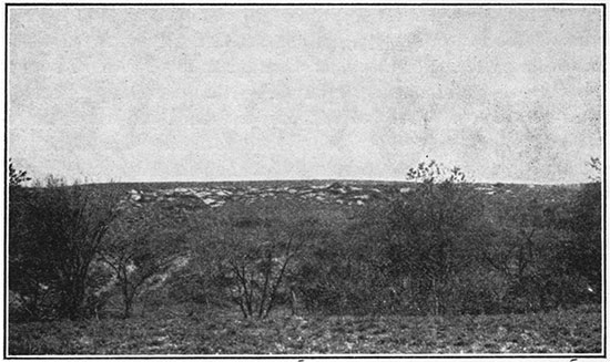
In western and northwestern Ellis County about 150 feet of the basal part of the Niobrara formation is in places excellently exposed in bare bluffs and badlands. In Kansas the formation has been separated into two readily recognizable members--the Smoky Hill chalk above and the Fort Hays limestone below.
Smoky Hill chalk member. About 100 feet of the basal part of the Smoky Hill chalk member is exposed below the overlapping Ogalalla formation in Ellis County. It consists of marl beds alternating with chalk and thin beds of clay. The member occupies a relatively broad area in the western part of the county, forming the gently rolling table-land above the Fort Hays limestone bench and below the Ogalalla formation. Because of the abundance of chalky shale and soft chalk it breaks down into smooth, gently graded slopes throughout most of its area of outcrop, but in some localities, particularly in the northward-facing slopes, it makes bare, intricately dissected badlands. There the more calcareous beds case-harden upon weathering and form protecting caps for the softer silty parts. This differential weathering results in buttes and scarps of fantastic shapes that range in color from a dazzling white through yellows to orange and orange-red. The harder chalk beds range in thickness from an inch to more than 1 1/2 feet. A marked characteristic of the exposed Smoky Hill beds is the abundance of fiat, circular limonitic concretions averaging about 10 or 12 inches in diameter, many of which have central cores of pyrite that occupy molds of fossil shells of Inoceramus (Haploscapha) grandis. Unaltered specimens of these large Inoceramus shells covered with masses of Ostrea congesta are quite as common as the limonitic concretions. In a few places lenses of a black, shiny carbonaceous, coaly-looking substance an eighth to a quarter of an inch thick and extending laterally for only a foot or two were seen in this member.
Because the member crops out over an extensive area, principally north and west of Ellis County, and presents the only possibilities for structural mapping throughout so much of western Kansas, the greater part of which is mantled by the Ogalalla formation, considerable stratigraphic detail was obtained in the hope that mappable marker beds might be found. The statement is frequently heard that the hard and soft beds in this member were not definitely stratified, but that the difference in hardness is merely a matter of weathering; in other words, that there are no beds in this member that can be traced reliably over distances sufficiently great to justify their use as key beds for structural mapping. Attempts have been made to follow bands of color in the weathered chalk, only to find that color changes transgress the bedding and are not confined within stratigraphic boundaries. Many domes and anticlines have been mapped in the areas of outcrop of the Smoky Hill member, in which the configuration of the contour lines has been based solely on dip readings. Because in the region of their outcrop the chalk beds are nearly everywhere intricately cut by faults, there appears to be at least some basis for doubt as to the value of this method of structural mapping in this region. Detailed study of the rocks lying within the interval of 70 feet above the base of the member afforded proof that there are two series of beds within these rocks that can be traced definitely. The outcrops of these two series of beds, usually the best-exposed parts of the member, were mapped throughout an area of 10 square miles in the northwestern part of Ellis County and were definitely recognized 10 miles or more farther away, but no attempt was made to trace the beds beyond the limits of the county. Although beds stratigraphically higher in the Smoky Hill member have not been studied in detail, reconnaissance observations of a series of hard and soft chalky shales and chalk with a few interlaminated bands of bentonitic clay, exposed in central and southern Logan County, 100 miles west of the area here discussed, lead the writer to the belief that key beds are present also within the higher portion of the Smoky Hill member.
The rocks that occupy the stratigraphic interval, from 70 to 100 feet above the base of the member, are not well exposed in the area studied in Ellis County, and little detailed information as to their character was obtained. The beds from 55 to 70 feet above the base are well exposed on the west side of the road in the SE NE, sec. 14, T. 12 S., R. 20 W. where they consist for the most part of very soft dull orange-colored chalk that weathers into cavernous-walled ledges with thinner layers of harder chalk interbedded with shale in the basal few feet. These rocks are sparingly fossiliferous and include a few limonitic concretions. The next lower 10 feet of the member is well exposed in many places and forms one of the readily traceable units, here termed group A. From 20 to 45 feet above the base of the member and in its lowest 10 feet the beds are poorly exposed, but from 10 to 20 feet above the base occurs another series of beds (group B) that can be followed throughout the area.
The upper group of readily traceable beds in the Smoky Hill member exposed in Ellis County lies from 45 to 55 feet above the base of the member. For convenience of reference these beds are here designated "Group A" beds. A typical section follows:
| Section of "group A" beds in sec. 2, T. 12 S., R. 20 W. | Ft. | In. | |
|---|---|---|---|
| 8. | Massive, brittle chalk nearly pure white; forms bench with surface strewn with white chalk chips; caps buttes. | 1 | 10 |
| 7. | Soft chalky clay shale, dull gray to slightly tannish gray; weathers readily and forms an indentation in bluffs. | 6 | |
| 6. | Bluish-gray chalky shale, harder than shale above and below it. | 6 | |
| 5. | Soft, chalky clay shale; weathers dull dark gray; is slightly indented in weathered bluffs. | 3 | |
| 4. | Very chalky shale, drab to blue-gray; in many places weathers yellowish gray. | 1 | 2 |
| 3. | Soft clay shale; weathers dull dark gray; makes prominent indentation in bluff. | 3 | |
| 2. | Drab chalky shale; weathers to light cream color; in places shows indistinct darker clay layer near middle. | 2 | 2 |
| 1. | Dark dull-gray clay shale, usually including near middle a bed of very chalky and harder shale 2 to 3 inches thick. In all exposures measured a layer of yellow bentonitic clay one-fourth inch thick was found 2 inches above the base. | 8 | |
Below this is more chalky shale that is a little harder than No. 1 and includes bands of softer clay shale, but it is so commonly covered in moderately gentle slopes that details of its parts are of little value. These slopes are typically strewn with the fiat, circular limonitic concretions. The rocks of the section given above commonly crop out in almost vertical cliffs that are capped by the chalk bed No. 8. Figure 4A is a diagrammatic sketch of the section here described. A view of a typical exposure is shown in Figure 5.
Figure 4--A. Diagrammatic sketch of "Group A" beds of Smoky Hill chalk member of Niobrara formation. B. Diagrammatic sketch of "Group B" beds of Smoky Hill chalk member of Niobrara formation.
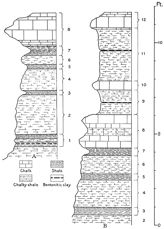
Figure 5--"Group A" beds of Smoky Hill chalk member. Hammer head is on bentonitic clay of No. 1, hat is on No. 3, and uppermost chalk is No. 8 of Fig. 4A.
West of the area mapped, in northeastern Trego County, some of the distinguishing features mentioned here appear to be lacking. The dark band recorded as No. 5 in the section is only faintly distinguishable, and No. 3 is likewise rarely well developed. The bentonitic clay of No. 1 in a zone of soft shale is present, however, and about a foot below it is a white chalk that shows in some of the sections measured in the vicinity of the one described above.
At the foot of the gentle shale slope that extends for 25 feet below the base of the "group A" beds is a second bench, terminating in low bluffs, that can be followed quite as definitely as the "group A" beds. In general its hard beds weather to a much deeper orange color than the "group A" beds, although its color can not be relied upon as a criterion to distinguish it. The following is a typical section of these beds, which are herein designated "group B" beds. Their top is 22 feet above the base of the Smoky Hill member.
| Section of "group B" beds in sec. 2, T. 12 S., R. 20 W. | Ft. | In. | |
|---|---|---|---|
| 12. | Chalk, cream-colored, brittle, massive in lower two-thirds; weathers thin bedded in upper part. | 10 | |
| 11. | Chalky shale; weathers to a deep yellow; includes an ocherous bentonitic clay band one-fourth inch thick, 1 foot 3 inches below the top. Upper 6 inches in places more chalky and not distinguishable from No. 12. | 2 | 11 |
| 10. | Chalk, brittle, from orange-yellow to cream-colored; makes slightly projecting ledge, in places jagged but generally blocky. | 3-8 | |
| 9. | Chalky shale, dull drab to blue; in places weathers to a dull ocherous tan; includes an ocherous bentonitic clay band one-fourth inch thick, 8 inches above base. | 1 | 5 |
| 8. | Chalk, relatively soft but. hard enough to form small rounded ledge. In places a soft band near middle makes of the unit a double-edged minor ledge projecting over the underlying beds. It ranges from dull orange-tan to cream-colored. | 1 | 10 |
| 7. | Soft, chalky clay shale, reddish tan; weathers into a pronounced indentation in bluff walls. | 4-6 | |
| 6. | Chalky shale, harder than No.7; weathers to a dull tan to cream color; bluish when fresh. | 1 | |
| 5. | Soft clay shale; weathers to dull gray or tan; makes a dark band slightly indented in bluff. | 4 | |
| 4. | Shale like No. 6. | 1 | 6 |
| 3. | Soft shale like No. 5. | 5 | |
| 2. | Shale like No. 6. | 1 | 9 |
| 1. | Soft chalky shale containing a yellow bentonitic clay band a quarter-inch thick | 3-4 | |
Figure 4B shows a diagrammatic sketch of the part from Nos. 3 to 12 of the section just described. Below No. 1 of the section is soft chalky shale, containing an abundance of large, flat limonitic concretions, which weathers readily to a gently inclined slope terminating at its base in the top bench of the Fort Hays limestone.
The "group B" beds can be distinguished from the "group A" beds by the thickness of the harder shales between the soft shale beds and by the occurrence of the two bands of bentonitic clay in the upper part, which are absent in "group A," and the occurrence of a bentonitic clay band in No. 1 of "group A" that is absent in "group B." The clay shale beds Nos. 3 and 7 are the most prominent soft members of the "group A" beds, and No.7 is the most prominent soft layer in the "group B" beds.
Fossils collected from the Smoky Hill chalk member are listed below. The fish was identified by J. W. Gidley, of the United States National Museum, and the remainder by J. B. Reeside, Jr., of the United States Geological Survey.
| Tooth of the large fish Hypsodon (Portheus) sp. |
| Globigerina bulloides D'Orbigny. |
| Inoceramus (Haploscapha) grandis Conrad. |
| Textularia sp. |
| Ostrea congesta. |
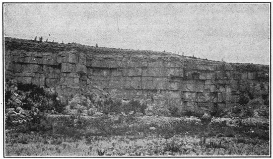
Fort Hays limestone member. Massively bedded cream-colored chalk or very chalky limestone, aggregating 55 feet in thickness, constitutes the Fort Hays limestone member of the Niobrara formation in Ellis County. The individual beds of chalky limestone range in thickness from 6 inches to 6 feet and average about 2 1/2 to 3 feet; these beds are separated by thin layers, 1 to 4 inches thick, of light gray to dark gray chalky clay shale. The bedding is thinner toward the top of the member, and the upper beds commonly weather almost pure white. In contrast with the chalk of the overlying Smoky Hill member the rock of the Fort Hays member appears slightly coarser in texture and somewhat harder. The individual beds are much thicker than those of the Smoky Hill, and weathered exposures of the two members show a marked contrast in the relative amounts of shale and hard beds, the Smoky Hill member having much the greater shale content. Rounded, coarsely ribbed shells of the pelecypod Inoceramus deformis are fairly abundant in the harder beds of the Fort Hays member. Individual beds and series of beds are persistent, with but little change in thickness over extensive areas. In many exposures that have been not long subjected to weathering thin bands of dark clay shale that separate the massive limestone beds differ from the adjacent beds only in being slightly softer, and some of the very thin layers appear only as cracks or joints along bedding planes. On weathered exposures, however, differences of hardness and general lithology are emphasized.
The uppermost few feet of the member contains more shale than the remainder, constituting in a measure a series of transition beds into the overlying Smoky Hill member. The following is a compiled detailed section of the Fort Hays limestone member. The topmost 8 feet of the section was measured in the NE NW NW, sec. 2, T. 12 S., R. 20 W., and the remainder in sec. 36, T. 11 S., It 19 W., Ellis County.
| Section of Fort Hays limestone member in T. 12 S., R. 20 W., and T. 11 S., R. 19 W. | Ft. | In. | ||
|---|---|---|---|---|
| Forms bench strewn with white chalk chips. | ||||
| 42. | Chalky limestone, soft; some clay shale | 2 | ||
| 41. | Shale, chalky, gray | 1 | ||
| 40. | White chalk | 1 | ||
| 39. | Tan clay shale | 2 | ||
| 38. | White chalk, rather soft | 1 | 2 | |
| 37. | Black clay shale; makes conspicuous band | 2 | ||
| 36. | White chalk and dark-gray chalky shale interbedded, in layers 2 to 6 inches thick. | 3 | 8 | |
| 35. | Chalky limestone, massive, light cream-colored. | 1 | 4 | |
| 34. | Clay shale; in places contains two 1/2-inch bands of yellow bentonitic clay. | 4 | ||
| 33. | Chalky limestone, cream-colored on weathered surface and very light cream-colored on fresh fracture; weathered surface is slightly hardened; massive. | 2 | 4 | |
| 32. | Dark-gray fissile clay shale. | 1 | ||
| 31. | Chalky limestone, like No. 35. | 1 | 2 | |
| 30. | Shale, like No. 32. | 1 | ||
| 29. | Chalky limestone, like No. 35. | 4 | ||
| 28. | Shale, like No. 32. | 1 | ||
| 27. | Chalky limestone, Like No. 35. | 1 | 1 | |
| 26. | Shale, like No. 32. | 1 | ||
| 25. | Chalky limestone, like No. 35. | 2 | 6 | |
| 24. | Shale, like No. 32. | 2 | ||
| 23. | Chalky limestone like No. 35. | 6 | ||
| 22. | Shale, dark gray to black; includes in some localities a band of yellow clay about one-half inch thick. | 3 | ||
| 21. | Chalky limestone, like No. 35. | 3 | ||
| 20. | Clay shale, tan, fissile. | 1 | ||
| 19. | Chalky limestone, like No. 35; a bedding plane 1 foot 4 inches above base may represent horizon of shale break in much weathered exposures. | 3 | 2 | |
| 18. | Clay shale, black, fissile. | 1 | ||
| 17. | Chalky limestone, like No. 35. | 1 | 11 | |
| 16. | Shale, like No. 18; includes thin band of light-colored clay at top. | 6 | ||
| 15. | Chalky limestone, like No. 35. | 4 | ||
| 14. | Dark-gray fissile shale, separated a little above middle by chalky limestone bed 2 inches thick. | 8 | ||
| 13. | Chalky limestone, like No. 35. | 2 | 6 | |
| 12. | Clay shale, tan to gray. | 4 | ||
| 11. | Chalky limestone, like No. 35. | 1 | 7 | |
| 10. | Clay shale, dark gray. | 3 | ||
| 9. | Chalky limestone, like No. 35. | 2 | 11 | |
| 8. | Shale, like No. 10. | 2 | ||
| 7. | Chalky limestone, like No. 35. | 4 | ||
| 6. | Shale, like No. 10. | 2 | ||
| 5. | Chalky limestone, like No. 35. | 3 | 9 | |
| 4. | Clay shale, tan. | 2 | ||
| 3. | Chalky limestone, like No. 35; includes a narrow band a little softer than remainder 2lh feet above base. | 6 | 3 | |
| 2. | Clay shale, dark tan to black, fissile. | 1 | ||
| 1. | Chalky limestone, like No. 33. | 1 | 9 | |
| Blue Hill shale member of Carlile shale. | ||||
| Total Fort Hays member | 56 | |||
Shells of the large pelecypod Inoceramus deformis and the small Ostrea congesta occur throughout the section, except possibly in the upper few feet.
Beds Nos. 42 to 36 are in few places well exposed, as they normally form a sparsely grassed slope strewn with white chalk chips that recedes from the cliff of harder beds below. Because of this tendency to break down into gentle slopes, the exact position of the contact of the Fort Hays member with the overlying Smoky Hill member is less readily determinable than the basal boundary of the Fort Hays. The chalky shale near the base of the Smoky Hill member, immediately above the white chip bench, however, weathers to a deep yellow or orange color, which delimits the position of the contact within a few feet.
Because it is considerably harder than the underlying Carlile shale, the Fort Hays limestone commonly stands in vertical bluffs that cap a steep, barren shale slope. In Ellis County the valley of Saline river is bordered with such bluffs throughout the area of outcrop of the Fort Hays member. The tributary streams have carved- and intricately serrated the valley walls, leaving a myriad of long, narrow spurs capped by cliffs of Fort Hays limestone that extend toward the main valley.
This member of the Niobrara is remarkably persistent and regular in its thickness and general character throughout western Kansas. It is readily identified in drilling, and is recognizable in the logs of nearly all wells that penetrate it. In its exposures in northern Hamilton County, near the Colorado line, the thin shale beds are more numerous and make up a little larger percentage of the member than they do in Ellis County. The chalky limestone beds also are somewhat softer, but on the whole the member has much the same appearance that it has in Ellis County. Its total thickness in Hamilton County is 60 feet. In the log of the Midfield No. 2 well, near Wray, Colo., a few miles west of the northwest corner of Kansas, it is recorded as 53 feet of white limestone.
Carlile Shale
Chalky and clay shale, about 300 feet thick, that contains thin beds of chalk near its base, numerous zones of septarian lime concretions in its upper half, and a unit of fine-grained sandstone at its top, constitutes the Carlile shale. The upper two-thirds is made up predominantly of gray-black fissile clay shale, and the lower third of chalky shale and thin beds of chalky limestone. In Ellis County it is separable into the Blue Hill shale member above and the Fairport chalky shale member below (Rubey and Bass, 1925, p. 33).
Blue Hill shale member. Ranging between a thickness of 215 feet near the northeast corner of the county and 175 feet near the southwest corner, the Blue Hill shale member occupies a broad belt of gently graded, grassed slopes in southern and eastern Ellis County and a narrow band of bare, steep slopes along Saline river in the northern part. The member is made up of gray-black noncalcareous clay shale, which at several horizons contains large calcareous or small ferruginous concretions, and in the uppermost 25 feet of gritty shale or sandstone.
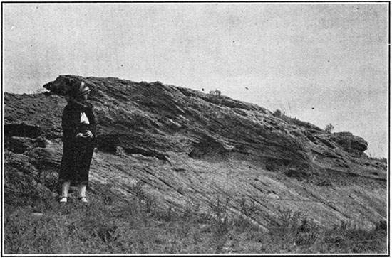
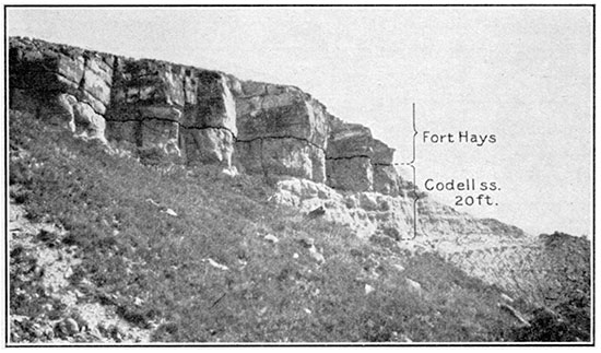
At the top of the Blue Hill shale member is a very fine grained sandstone, including a few layers of sandy shale. In northern Ellis County, where this unit is thick, the uppermost few inches contains considerable clay that erodes easily and forms a small notch in the cliff produced by the overlying Fort Hays limestone. Below this clay is an indurated sandstone bed 5 to 6 feet thick that weathers to a bright tan color and forms a curved cliff face. (Fig. 6.) About 1 foot of shaly sandstone separates this 5- to 6-foot bed from an underlying gray indurated sandstone 3 to 5 feet thick that stands in a vertical cliff. The basal sandy material grades into the shale below and in most of its outcrops form gentle slopes. Because of its unusually thick development in a series of excellent exposures in the bluffs along Saline valley in Ellis County 5 miles south and a little west of Codell, this sandy unit of the Blue Hill shale member is here named the Codell sandstone bed. It is well exposed in a road cut near the north boundary of Ellis County in the NE, sec. 3, T. 11 S., R. 17 W., where it is 22 feet thick. Farther west, north of Saline river, from 10 to 13 feet of the upper part of the sandstone is exposed at several localities. It is 20 feet thick in the NW, sec. 26, T. 11 S., R. 18 W. The lower part of the Codell bed becomes less sandy southward, and at Yocemento, in T. 13 S., R. 19 W., it consists of but 3 1/2 feet of sandstone underlain by 6 feet of sandy shale. Near the southwest corner of the county, in sec. 21, T. 15 S., R. 20 W., the sandstone material is only 3 1/2 feet thick, but the shale for a considerable thickness below it includes numerous thin layers of sand and sandy shale.
Figure 6--Codell sandstone bed of Blue Hill shale member of Carlile shale. NW, sec. 26, T. 11 S., R. 18 W., Ellis County.
Well logs show the Codell sandstone bed to be present over a considerable part of western Kansas. Its outcrop is characteristically marked by water seeps. Many drilled wells in Ellis County and counties adjacent on the north and west derive water from it. About 80 miles to the west, near Russell Springs, water wells have been drilled to depths of about 800 feet to this sandstone. The water from these wells has a foul taste and although good enough for stock is rarely used for drinking. The Codell sandstone is present near the Colorado state line in Hamilton County, where it consists of sandstone about 2 feet thick in the upper part underlain by 20 feet of gritty shale that contains very thin streaks of shaly sandstone.
Gray-black fissile noncalcareous clay shale containing several layers of calcareous concretions makes up the remainder of the Blue Hill shale member. Crystals of selenite are commonly strewn upon the weathered surface, especially in the lower part of the member. The uppermost concretion layer occurs just beneath the Codell sandstone bed, about 25 feet below the top of the Blue Hill member. The concretions at this horizon are not. numerous, occurring 15 to 25 feet apart horizontally. They have the appearance of slightly flattened spheres averaging 2 to 3 feet in diameter, are of a steel-gray color, have a coarsely granular texture, and contain relatively few thin septae filled with crystalline calcite veins. In general they are more smoothly rounded than those found at lower horizons. In the southwestern part of the county the interval between 45 and 85 feet below the top of the member is strewn with large septarian concretions shaped for the most part like flattened spheres, but many are of odd nodular shapes. (Fig. 7.) The topmost and lowest concretions of this group, which apparently occur at definite stratigraphic horizons, are readily distinguished from the others by their very red weathered surfaces. The concretions of the other horizons weather to a dull gray or brown color. It is probable that the concretions that appear to occur heterogeneously throughout the interval between the two layers of red ones are likewise definitely stratified, but because of their persistent habit of slumping on a weathered slope true stratigraphic positions of individual concretions cannot be determined. Two layers of similar large reddish-brown concretions, the upper about 100 feet and the lower 135 feet below the top of the member, occur in northeastern Ellis County and northwestern Russell County, but concretions at these horizons were not seen in the exposures in southwestern Ellis County. There a definite layer of septarian concretions ranging in diameter from 6 inches to 2 feet occurs about 45 feet above the base of the member. Gypsum crystals are most abundant in the shales below this concretion bed. In northeastern Ellis County and northwestern Russell County, at 31 feet above the base of the member, is a concretionary ironstone bed 1 to 2 inches thick, and 16 feet above it is a layer of small flat septarian concretions.
Figure 7--Weathered septarian concretion in Blue Hill shale member of Carlile shale. Sec. 21, T. 15 S., R. 20 W., Ellis County.
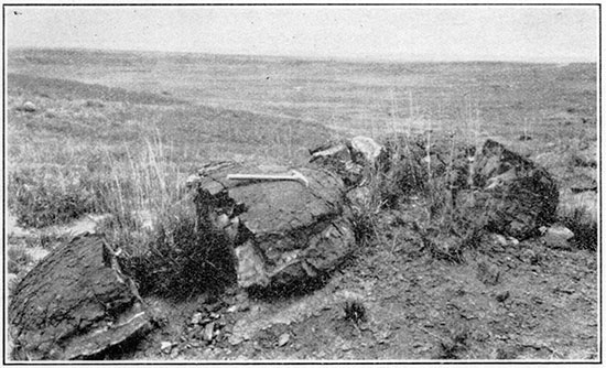
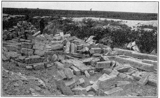
Figure 8--Quarry in the "fence-post limestone" bed of the Pfeifer shale member of the Greenhorn limestone. Sec. 27, T. 17 S., R. 15 W., Barton County.
Fairport chalky shale member. Increasing from a thickness of 85 feet in the northeastern part of Ellis County to 115 feet near the southwest corner, the Fairport chalky shale member of the Carlile shale occupies a broad area of low relief in the southern and eastern parts of the county. It is composed throughout of calcareous shale, including thin beds of chalky limestone, which occur in greatest abundance toward the base of the member. On fresh exposures it is bluish, but its weathered surface is a light orange-tan. The lower half characteristically has in addition a pink tinge, which gives it a flesh color. The individual thin beds of chalky limestone in the lower part of the Fairport are very persistent laterally, and the series of chalky limestones and shales in the basal 25 feet of the member were noted at many localities in Russell and Ellis counties, and were found to remain practically constant in their relative positions and intervals above the Greenhorn. [Note: A detailed stratigraphic section of this member is given in Kansas Geol. Survey Bull. 10, p. 40, 1925.]
The limestones and shales are abundantly fossiliferous, the fossils being more perfectly preserved in the limestones. Thin smooth shells of the small oyster Ostrea congesta occur abundantly in the shales, however, and are in many places thickly strewn upon the weathered slopes of the member.
This member, particularly the lower half, is lithologically not unlike the underlying Greenhorn limestone, but its contained fossils furnish the basis for separation. The boundary between the Fairport member and the Greenhorn limestone is placed on paleontologic grounds at the top of the "fence-post limestone" bed. The upper boundary of the Fairport member is not so sharply defined throughout the county as the base. In good exposures it can readily be determined within a few feet by the calcareous character of the Fairport shales and their weathered orange-tan color, in contrast with the noncalcareous character and gray-black color of the overlying shales and their increased stickiness when wet. Seeps of water commonly occur at or near this contact.
This lower member of the Carlile shale continues to increase in thickness westward beyond the boundaries of this county. In Hamilton County, less than 5 miles from the Colorado line, it is approximately 150 feet thick and maintains in general the characteristics described above. There, as in Ellis County, the basal part of the member is lithologically very similar to the underlying Greenhorn limestone and is separable from it chiefly by a change in the contained fossils.
The following fossils collected from the member were identified by J. B. Reeside, Jr., of the United States Geological Survey:
| Prionotropis woolgari (Mantell). |
| Serpula plana Logan. |
| Inoceramus fragilis Hall and Meek. |
| Globigerina bulloides D'Orbigny. |
| Textularia sp. |
| Ostrea congesta. |
Greenhorn Limestone
The four members of the Greenhorn limestone described in the Russell County report (Rubey and Bass, 1925, p. 45) are readily recognizable in Ellis County, where they have a total thickness of nearly 100 feet. The entire formation occupies but little more than 15 per cent of the surface of Ellis County, largely because of the steepness of its slopes. It is extensively exposed in the southern and southeastern parts of the county, and extends a few miles up Saline river in the northeastern part.
Pfeifer shale member. The uppermost member--here named Pfeifer shale member for its exposures near Pfeifer, Ellis County--is capped by the "fencepost limestone" bed, so called because it is extensively quarried and used for fence posts throughout the region of its outcrop. (Fig. 8.) The Pfeifer member is 19 to 21 feet thick and consists of alternating layers of chalky shale and chalky limestone, the latter in beds from 3 to 8 inches thick. On fresh exposure the entire mass presents a blue color, but on weathering it becomes a light tan or cream. In general the member produces gently graded slopes, the topmost bed forming a slight shoulder. Its outcrop throughout this region is commonly marked by white mounds of the overburden removed in quarrying the "fence-post limestone" bed. The following section was measured 2 1/2 miles northwest of Pfeifer:
| Section of Pfeifer shale member in road cut in SE sec. 21, T. 15 S., R. 17 W. | Ft. | In. | |
|---|---|---|---|
| 24. | "Fence-post limestone," chalky limestone, light tan, even grained, including near the middle a rusty band about an inch wide and a little lower another rather indistinct band. Contains a few well-preserved fossils (Inoceramus labiatus). Top bed of Pfeifer member. | 8 1/2 | |
| 23. | Soft chalky shale, cream to flesh colored. | 11 | |
| 22. | Chalky limestone, somewhat concretionary; weathers white; contains a few fossils. | 1 | |
| 21. | Chalky shale like No. 23. | 10 | |
| 20. | Concretionary chalky limestone, fossiliferous; weathers white. | 4 | |
| 19. | Shale, like No. 23. | 1 | 2 |
| 18. | Chalky limestone, with no fossils; weathers white. | 1 | |
| 17. | Chalky shale, like No. 23. | 11 | |
| 16. | Chalky limestone, like No. 18. | 4 | |
| 15. | Shale, like No. 23, with a band of bentonitic clay 4 inches thick at its top. Upper part of clay band gritty and shows orange color. | 1 | 2 |
| 14. | Concretionary fossiliferous chalky limestone. | 2 | |
| 13. | Chalky shale; weathers flaky; light tan; in places contains a thin discontinuous bed of somewhat fossiliferous concretionary chalky limestone | 1 | 6 |
| 12. | White chalky limestone, very few fossils. | 3 | |
| 11. | Shale, like No. 13, somewhat fossiliferous; in places has two thin discontinuous beds of fossiliferous concretionary chalky limestone. | 2 | 4 |
| 10. | Chalky limestone; weathers to rusty brown; ferruginous band near middle; contains many fossils. | 2 | |
| 9. | Shale, like No. 13. | 10 | |
| 8. | Chalky limestone; very few fossils. | 3 | |
| 7. | Shale, like No. 13. | 1 | |
| 6. | Concretionary chalky limestone, fossiliferous. | 2 | |
| 5. | Shale like No. 13. | 9 | |
| 4. | Concretionary chalky limestone; fossils abundant. | 2 1/2 | |
| 3. | Shale like No. 13. | 1 | 4 |
| 2. | Concretionary chalky limestone; fossils abundant. | 4 | |
| 1. | Shale like No. 13. | 3 | 1 |
| Total thickness of Pfeifer shale member. | 18 | 11 | |
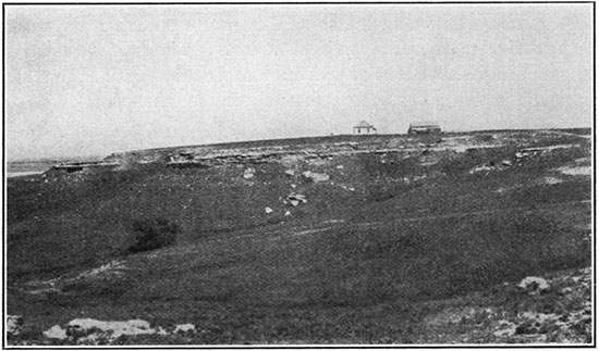
Jetmore chalk member. Underlying the Pfeifer shale member is 20 feet of interbedded chalky shale and chalky limestone known as the Jetmore chalk member (Rubey and Bass, 1925, p. 46). The chalky limestone beds of this member are harder than those of the overlying Pfeifer member, and the uppermost bed, which approaches a foot in thickness, is hard, inclined to be concretionary, and characteristically forms a bench, with its blocks scattered along the edge. (Fig. 9.) The hard beds of the upper half of the member are much more abundantly fossiliferous than those above and below, many of them being composed almost entirely of shells of the pelecypod Inoceramus labiatus. The base of the member is not sharply defined in Ellis and Russell counties. The chalky limestone beds become thinner and less numerous in the lower part of the Jetmore member and grade into the calcareous shale of the underlying Hartland member. Because of the predominance of beds of hard, white, chalky limestone, the member weathers in steep, almost bare, light-colored slopes.
Figure 9--Typical outcrop of the uppermost chalk bed in the Jetmore chalk member of the Greenhorn limestone. Sec. 8, T. 23 S., R. 24 W., Hodgeman county. View southward.
Hartland shale member. Below the Jetmore chalk member is a series, about 35 feet thick, of chalky shales that contain a few thin beds of soft chalky limestone and a few thin layers of bentonitic clay. In Ellis and Russell counties these beds, which are herein named Hartland shale member, from exposures near Hartland, Kearny County, Kansas, grade into the overlying Jetmore member with no sharp change in lithology, and are defined somewhat more distinctly below by the hard, thin-bedded, finely banded, dark-colored limestone of the basal member (Lincoln limestone) of the Greenhorn limestone.
Lincoln limestone member. The basal or Lincoln limestone member (Rubey and Bass, 1925, p. 47) of the Greenhorn limestone consists of about 20 feet of chalky shales with thin beds of light-gray chalky limestone and of hard, finely banded, dark-colored crystalline limestone. The beds of crystalline limestone are most abundant at the base and top of the member, are fossiliferous, and emit a strong bituminous odor when broken. Several thin layers of bentonitic clay that weather to an orange color are contained in the shales. The color of these layers and the brown of the weathered crystalline limestones give the member on the whole a much yellower color than other members of the Greenhorn limestone.
Comparison with Greenhorn limestone exposed in other localities. The four divisions within the Greenhorn limestone are readily recognizable and persistent both southwest and northeast of Ellis County, throughout an extensive area along the outcrop of the formation. Nearly 150 miles southwest of Ellis County where the Greenhorn limestone is exposed along the Arkansas valley in Kearny and Hamilton counties, similar divisions can be recognized, but the upper two are less easily distinguishable. There the entire formation has a thickness of 130 feet, the upper 74 feet of which is made up of alternating chalky shale and chalky limestone beds corresponding to the Pfeifer and Jetmore members--the top 25 feet representing the Pfeifer and the remainder, which contains layers of abundantly fossiliferous chalky limestone, the Jetmore. This 74 feet of chalky and limy beds in Hamilton and Kearny counties is herein named Bridge Creek limestone member of Greenhorn limestone, from exposures on Bridge creek, northwest of Medway, Hamilton County. It is immediately underlain by chalky shale 23 feet thick. This shale unit, herein named Hartland shale member, is in turn underlain by the Lincoln limestone member, which consists of 35 feet of chalky shale alternating with thin beds of chalky limestone and of finely banded crystalline limestone.
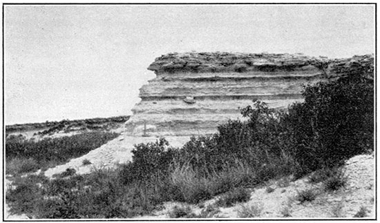
Figure 10--Bluff of Fort Hays limestone member of Niobrara formation at old quarry at Yocemento, Ellis County.
Graneros Shale
A narrow strip in the southeastern part of Ellis County along Smoky Hill river is occupied by the Graneros shale. It is made up predominantly of blue-black fissile noncalcareous clay shale. Numerous thin lenses of sandy shale, sandstone, sandy limestone, and ironstone concretions are interbedded with the shale. Selenite crystals are commonly strewn over the surface, and the shale has a bitter taste. The following section was measured in the south bank of Smoky Hill river:
| Section of Graneros shale in the NE sec. 34, T. 15 S., R. 16 W. | Ft. | In. | |
|---|---|---|---|
| 14. | Black or gray-black fissile clay shale. | 2 | |
| 13. | Grayish-tan sandy shale, with interlaminated thin stringers of sandstone and shale; about 60 per cent sandstone and 40 percent shale. | 3 | 6 |
| 12. | Shale, similar to No. 14. | 5 | |
| 11. | Very shaly fossiliferous limonitic sandstone. | 1 | |
| 10. | Shale, like No. 14, but containing a small amount of gypsum crystals on the surface. | 1 | 6 |
| 9. | Very limonitic and gypsiferous sandy shale and sandstone interlaminated. Estimated lower half 95 per cent sandstone and upper half 50 per cent. | 1 | |
| 8. | Black gritless bitter-tasting noncalcareous paper shale; selenite crystals abundant on surface. | 5 | |
| 7. | Reddish-brown limonitic sandstone with an abundance of fossils | 3/4 | |
| 6. | Shale, like No. 8. | 2 | 6 |
| 5. | Irregularly interlaminated sandstone and shale and thin stringers of gypsum. Sandstone estimated at four-fifths of whole. Basal 2 inches weathers to tan-brown color and remainder to red-brown. Makes slight irregularity in shale slope. One sandstone layer strongly ripple marked. | 1 | |
| 4. | Gray-black fissile noncalcareous shale, in part slightly gritty, with a bitter taste. | 3 | 6 |
| 3. | Dark-gray sandy shale, increasing in sandiness to top. Ironstone concretion bed at base averaging 2 inches thick, One irregular concretion 6 inches thick and 1 foot 6 inches in horizontal dimensions was noted. | 1 | |
| 2. | Black to gray-black, slightly gritty shale with bitter taste. | 2 | |
| 1. | Black to gray-black bitter-tasting shale, sandy at top and containing a thin layer of limonite concretions. Decreases in sandiness downward, and basal part only slightly gritty. | 3 | |
| Dakota sandstone | |||
| Total thickness of Granerous shale | 32 | ||
The Graneros is somewhat thinner in this section than in near-by places where it was measured. The average thickness of the formation in Russell County is about 40 feet (Rubey and Bass, 1925, p. 51). In sec. 23, T. 22 S., R. 22 W., Hodgeman county, nearly 50 miles southwest of the locality of the above section, the formation has a total thickness of 38 feet and is made up of black fissile clay shale that contains numerous thin beds of rusty-colored sandstone and ironstone and considerable gypsum in the lower 8 feet and a rusty-colored sandy shale bed, 10 inches thick, about 23 feet above the base. In a compiled section measured in western Kearny and Hamilton counties, near the west edge of the state, the formation has a total thickness of 61 feet and consists largely of blue-black fissile clay shale. Ironstone concretions and impure sandstone lenses are present in the basal few feet, and at 23 feet above the base is a zone about 5 feet thick containing thin-bedded sandy fossiliferous limestone. A persistent bed of white bentonitic clay occurs 11 feet below the top.
Dakota Sandstone
Only the uppermost 18 to 20 feet of the Dakota sandstone is exposed in Ellis County and that in an area of only a few acres. It rises from beneath the level of Smoky Hill river in the NW, sec. 35, T. 15 S., R. 16 W., and arches over the axis of a northeastward trending fold here called the Pfeifer anticline. In this exposure the Dakota sandstone consists, from the top down, of 5 feet of massively bedded fine-grained light-gray sandstone, containing an abundance of carbonized plant fragments; a zone 1 foot thick, of pyrite concretions embedded in sandstone; and 8 feet of massive fine-grained sandstone. These rocks represent the upper regularly bedded sandstone unit of the Dakota sandstone described in Bulletin 10 of this survey (Rubey and Bass, 1925, p. 54). The rocks between the base of the sandstone and the river bed are concealed by alluvium.
The log of a well drilled in sec. 3, T. 16 S., R. 16 W., Rush county, about a mile south of this exposure records 140 feet of white sand in the upper part of the Dakota. The logs of the three wells drilled for oil in the northeast quarter of the county bear out the fact noted in the Russell County outcrops that individual beds or groups of beds in the Dakota are extremely lenticular and variable. These logs, however, in general show from the top down 25 to 85 feet of sandstone that carries water, 100 to 130 feet of material recorded largely as red rock, a light-colored water-bearing sandstone 50 to 100 feet thick, a little more than 100 feet of dark shale, and about 100 feet of white sandstone. The log of the Smith well, in sec. 14, T. 12 S., R. 16 W., shows the basal sandstone absent there. The lower black shale and sandstone units very probably constitute the Comanche rocks, which crop out in central and south-central Kansas.
Many wells throughout the county obtain water from the Dakota; this water is commonly too salty for domestic use but is used for stock.
Rocks Not Exposed
M. N. Bramlette made microscopic studies of drill cuttings from wells drilled in and to the east of Russell County for the purpose of tracing westward the formations that crop out in eastern Kansas. In his description he separated the rocks into units, most of which included several formations. The detailed results of Mr. Bramlett's studies are published in Part II of Kansas Geological Survey Bulletin 10, pages 87-93.
Solely on the basis of the drillers' logs, for no well cuttings were available, the buried rocks in Ellis and Trego counties have been correlated with those in Russell County. Plate II shows a correlation table of wells in a line westward from the Russell pool, including two wells in Ellis County and two in Trego County. So far as possible Bramlette's groupings are followed.
Unit 1. All rocks younger than the Dakota sandstone are included in unit 1, for few of the formation boundaries are recognizable in the logs. In Ellis County this unit contains only parts of the Carlile, Greenhorn, and Graneros formations, but the Trego County wells penetrate several hundred feet of the Niobrara formation, the basal member of which, the Fort Hays limestone, is recorded as white limestone from 50 to 60 feet thick.
Unit 2. The next unit contains the Dakota sandstone and very probably in its basal part rocks of Comanche age. Light-colored to white sandstone and shale, irregularly bedded with red and mottled shale, are characteristic of the upper half of the unit, and dark shale and white to yellow sandstone of the lower half. The sandstones commonly carry water, which in most wells in this region is salty. [For a description of surface exposures of the Comanche in Kansas, see Twenhofel, W. H., The Comanche of Kansas: Kansas Geol. Survey Bull. 9, 1924.] W. H. Twenhofel and W. L. Stryker in their report of studies of the subsurface distribution of the Comanche rocks in western Kansas (Twenhofel, and Stryker, 1925) describe the Comanche beds in two of the wells included in Plate II, Nos. 1 and 5. In well No. 1 they placed the top of the Comanche at a depth of 372 feet, at the top of a bed of soft red sandstone, and the base at 560 feet. In the Davidson well, No. 5 of Plate II, the rocks between 1,240 and 1,325 feet are assigned to the Comanche, the sandstone occupying the lowermost 85 feet of this unit being the Cheyenne sandstone. This assignment shows a thickening of the Comanche westward, which is in harmony with Twenhofel and Stryker's observation that these rocks thicken westward and southward from the Russell oil field, where they are about 200 feet thick.
Plate II--Correlation of well records in Russell, Ellis and Trego counties, Kansas. An Acrobat PDF version of this figure is available.
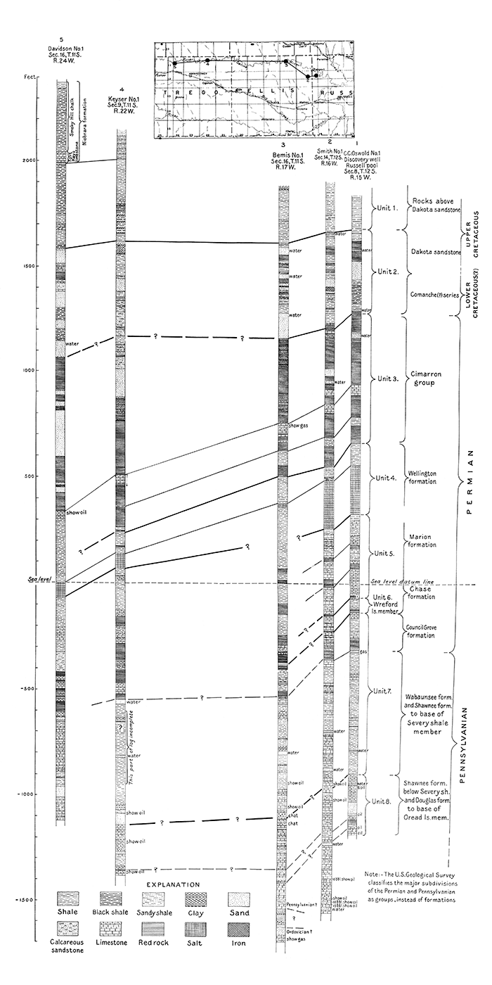
Unit 3. Ranging in thickness from 600 feet in the east to 900 feet in the west, unit 3 forms a rather clearly defined division constituting the Cimarron group of the Permian "Red Beds" (Moore, 1920). The rocks of this group are largely red siltstones with minor amounts of sand in Russell and Ellis counties, but the proportions of sand--much of it white rather than red--increases greatly westward, according to the logs of the Trego County wells. A widespread marker bed that is recorded as "gray lime," about 50 feet thick, occurs in the basal part of the unit. Bramlette states that the cuttings from this bed in wells in and east of Russell County are anhydrate, and a specimen taken in the Polifka well, in central Ellis County, is anhydrite. A bed of blue shale 65 feet thick that occurs about 100 feet below the anhydrite bed in the Bemis well, in northeastern Ellis County, can be followed westward to the Keyser well, in Trego County, where it has thinned to 5 feet, and eastward into Russell County.
Unit 4. The fourth unit includes from 60 to 220 feet of beds that are usually recorded as blue shale and salt beds ranging in thickness from 21 feet in the Bemis well to 227 feet in the Smith well. The log of the Polifka well (not shown in the correlation table, Pl. II), near the center of Ellis County and only 12 miles south of the Bemis well, reported 230 feet of salt. Inasmuch as this series of salt beds is very widespread and of rather uniform thickness throughout many counties in west-central Kansas, its reported thinning in the Bemis well is noteworthy. This unit is a part of the Wellington formation.
Units 5 and 6. Bramlette's separation of units 5 and 6 was based largely on a microscopic study of cuttings, and the projection of the units into Ellis County by log correlations is exceedingly difficult. Its position as indicated on Plate II is, therefore, subject to question. The basal limit of unit 5 is likewise indefinite. The two units, probably all in the Permian, include a series of rocks recorded by drillers as interbedded shale and limestone with much red material. Bramlette correlated unit 6 with the Wreford limestone.
Units 7 and 8. Unit 7, probably including rocks from a horizon a little above the base of the Permian through the Severy shale of the Pennsylvanian, is composed largely of shale with a few beds of limestone. Individual beds in the unit cannot be traced in the logs of wells in Ellis County and Trego County. Unit 8 includes mostly limestone, and in its lower part, thin beds of sandy shale; at its base is the original "pay sand" of the Russell oil pool. This unit probably represents limestones of the lower part of the Shawnee formation and includes at its base the Oread limestone.
Approximately 350 feet of thick limestone beds, the lower 50 feet reported to contain much sand, were penetrated in the Smith well below the horizon of the original "pay sand" of the Russell field, but in the absence of cuttings from these rocks, few inferences can be ventured as to their probable stratigraphic position. So few identifiable marker beds of the Oswald and Smith logs can be definitely correlated with the strata recorded in the Bemis log that considerable doubt must be expressed as to the correctness of the correlations of the lower rocks shown on Plate II.
The presence of an unconformity in the buried rocks of the region situated 400 feet more or less below the Russell oil-producing beds was indicated by the record of the Phillips well of the M. M. Valerins Oil & Gas Co., drilled in sec. 3, T. 13 S., R. 13 W., 25 to 60 miles southeast of the Bemis well. In material from the Phillips well Pennsylvanian fossils (Bramlette, 1925, p. 93) were identified from rocks that lie between the horizon of the Russell oil sands and a series of red rocks about 350 feet lower, and fossils of Ordovician age were identified from rocks below this red-rock series. The general sequence of beds below the horizon of the Russell oil-producing beds in the Bemis well appears to correspond to that in the Phillips well. On this basis tentative well-log correlation indicates that the series of limestone and shale about 100 feet thick immediately below the horizon of the Russell producing beds in the Bemis well is of Pennsylvanian age, that the series of red beds lying next below is in part of early Pennsylvanian age and probably in part older, and that the sandy limestone in the basal part of the well is of Ordovician age. Logs of other wells drilled recently in this part of the state indicate that this unconformity is present throughout an area embracing several counties.
The chief events that appear to have taken place in the formation of this series of beds may be briefly set forth. The lowermost beds penetrated in the Bemis well were deposited on the sea bottom in Ordovician time, and other deposits accumulated above them. The region was later elevated above the sea, and the land thus formed was subjected throughout a long period of time to the agencies of erosion. The red beds and gravel recorded in the log were accumulated on this old land surface. Later, in Pennsylvanian time, the sea again covered the land, and shale and limestone were alternately laid down, layer upon layer.
Beds Useful for Structural Mapping
The Dakota sandstone occupies so small a part of the surface of Ellis County that its importance as a key bed suitable for structural control is slight. Furthermore, because of its irregular, lenticular bedding, it is not believed to be reliable for such mapping except in a regional study covering relatively large areas. The few hard layers in the Graneros shale may be valuable as key beds in a few places, but in the main they will never be used. The Lincoln limestone member of the Greenhorn limestone, which immediately overlies the Graneros, is commonly well exposed and forms ledges that in a horizontal plan almost coincide with the outcrop of the hard beds in the Graneros, a fact which largely vitiates the usefulness of the beds in the lower formation. In many localities, however, both the basal and the topmost beds of the Lincoln member constitute excellent key beds.
The two markers most widely used in this part of the state for structural mapping are the uppermost beds of the Jetmore and Pfeifer members of the Greenhorn limestone. The top bed of the Jetmore member is slightly thicker and harder than the other beds, has a slightly concretionary tendency, and weathers into gray-white blocks that lie strewn along the edge of a steep-sided bench. (Fig. 9.) Its position above the abundantly fossiliferous limestone beds that occur in the Jetmore member and below the relatively soft shale and thin soft chalky limestone of the overlying Pfeifer member aids in its recognition. The "fence-post limestone"--the top bed of the Pfeifer member--is marked along much of its outcrop by small white mounds of chalky shale, the overburden that has been removed from old stone quarries. Its uniform thickness, ranging between 8 and 9 inches, and its even texture assist in its recognition. It caps a gentle slope that rises for 20 feet above the weathered blocks of the topmost bed of the Jetmore member. In clean exposures three layers of thin, flat chalky limestone concretions can be seen in the 4 1/2 feet of shale immediately above the "fence-post" bed.
In the Carlile shale a chalky limestone bed 4 to 5 inches thick that occurs 5 1/2 feet above the base of the Fairport member is readily recognizable by the presence immediately below it of an orange-yellow bentonitic clay bed 5 inches thick. At 11 feet above the base of the Fairport member is a layer of ellipsoidal chalky limestone concretions averaging about 8 inches in thickness and a foot in diameter that readily distinguishes the limestone beds that occur stratigraphically near it. The three thin beds of chalky limestone that occur in the interval from 20 to 25 feet above the base of the member and weather to a red-brown to tan color may be recognized, and are sufficiently hard to form minor benches and make useful key beds for mapping. Although the upper part of this member is not so extensively exposed as the basal 25 feet, higher groups of chalky limestone are recognizable from place to place by the thin layers of bentonitic clay in the shales associated with the hard beds and can be traced in the clean exposures along Smoky Hill river. The contact between the two members of the Carlile shale is difficult to follow in detailed mapping, although usable in many places for reconnaissance work. The several layers of concretions in the Blue Hill member can not be used over extensive areas. The large concretions slump so readily in the soft shale in which they are embedded that little confidence can be felt as to their being in their true stratigraphic position. The ironstone bed 31 feet above the base, however, can be traced readily throughout much of its outcrop in the northeastern part of the county.
The base of the Fort Hays limestone member is sharply defined and is an admirable key horizon if certain precautions are taken. On many long, narrow tongues of outcrop left by erosion the member has slumped below its true level, owing to the giving way of the soft shale below, and its altitude in such places must be disregarded. Individual beds in the Fort Hays member can be identified by careful measurement of sequences of beds. Although rarely well exposed, the contact between this member and the overlying Smoky Hill member is in many places sufficiently well marked for reconnaissance mapping. The top beds of the Fort Hays member weather into white chalk chips and form a low bench, above which is a gentle slope of dark-yellow chalky shale constituting the. basal beds of the Smoky Hill member. The rocks designated "group A" beds and "group B" beds in the description of the Smoky Hill member (pp. 19-23) are series of soft and hard beds that can be traced extensively and be used as key beds. It is thought very probable that detailed study of beds in the Smoky Hill member stratigraphically higher than those exposed in Ellis County will reveal other groups sufficiently distinctive to serve as key beds in extensive areas farther west in Kansas.
Structure
Attitude of the Greenhorn Limestone
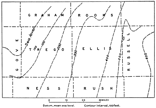
The Cretaceous rocks in Ellis County have a regional dip of about 10 feet to the mile in a direction slightly east of north. A series of broad, gently arched northeastward-trending noses form gentle undulations on the northward-dipping surface. The more prominent structural features of the area are shown on Plate III, by contours drawn on the top of the Greenhorn limestone. The map was made from the reconnaissance geologic sketch map, for which the Hays, Ellis, Plainville, and Hill City topographic maps were used as a base. Dashed contour lines are drawn in smooth curves across broad areas mantled by Tertiary rocks, although the true structure is probably much more irregular. The representation of structure here given is of course not accurate in detail, but it is believed to present a true picture of the regional features.
Plate III--Reconnaissance structural contour map of Ellis County, Kansas. An Acrobat PDF version of this figure is available.
The most pronounced structural feature of Ellis County is a northeastward-trending fold that crosses the southeast corner of the county and extends into Russell County. This fold, here called the Pfeifer anticline, appears to be in general alignment with the Fairport-Natoma anticline of Russell and Osborne counties. It may not, however, be a direct continuation of that anticline, but rather lie somewhat en echelon to it. Like the Fairport-Natoma anticline, it is steeper on the west flank, where dip readings as great as 3 1/2 degrees were noted.
A rather sharp syncline parallels the Fairport-Natoma and Pfeifer anticlines on their west side and is in tum paralleled on the west by a series of "structural highs," much less pronounced than the Fairport-Natoma and Pfeifer anticlines, that extend from the northeast comer of Ellis County southward to Pfeifer. A broad nose strikes northward across the middle of the county and turns slightly to the east in the northern half. A rather pronounced anticline, trending a little east of north, extends from the northwestern part of Ellis County into Rooks county in R. 19 W. A northeastward-trending nose is present in the southwest corner of the county. These two folds in the western part of Ellis County show alignments nearly parallel to those of the Fairport-Natoma and Pfeifer anticlines respectively (Plate III) and may possibly represent a similar but less strongly folded series of anticlines.
Structure of the Pre-Cretaceous Rocks
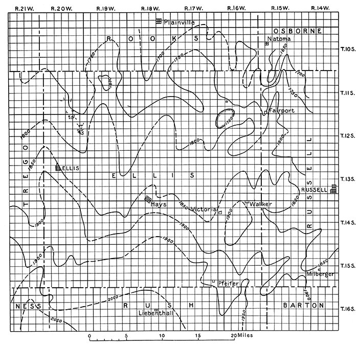
Rocks lying below those of Cretaceous age have a regional inclination slightly north of west in Ellis and Trego counties (Fig. 11). The average rate of slope in the eastern half of the county is 10 feet to the mile and in the western half a little less than 7 feet to the mile. The "Red Beds" were subjected to erosion prior to the deposition of the Cretaceous rocks, and about 400 feet more of "Red Beds" material was removed from the eastern part of Ellis County than from the western part of Trego County. Well logs consequently show a thickening of the "Red Beds" westward. If this westward thickening of the "Red Beds" is assumed to take place at a uniform rate, a well drilled near the west edge of Ellis County would have to penetrate 200 feet of sediments below the Cretaceous beds that are not present in the eastern part of the county. Wells drilled on the Fairport-Natoma anticline in western Russell County show that the degree of deformation of the rocks involved in the fold increases in depth (Rubey and Bass, 1925, p. 71), and it is to be expected that structural features shown at the surface in Ellis County are likewise accentuated in depth.
Figure 11--Altitude of the top of the salt beds of the Wellington formation in Ellis and adjacent counties.
Faults
In reconnaissance mapping of the type carried on in Ellis County it is not possible to detect all faults; in general only those that occur near the roads are noted. Plate IV shows a small tract in the northwestern part of the county in which more detailed mapping was done, disclosing a total of 76 faults. In this tract the Smoky Hill. member of the Niobrara formation occupies about 80 per cent of the area that contains Cretaceous rocks at the surface and in it are found 97 per cent of the observed faults. Because of the difficulty of identifying marker beds in the faulted chalk, on many of the faults it was impossible to determine the amount of displacement. The faults show no predominant direction of trend. Of the forty-four in which the amount of displacement was determined, twenty-seven have an apparent throw of 5 feet or less, seven range between 5 and 10 feet, five range between 10 and 15 feet, four range between 15 and 25 feet, and one has an apparent throw of 80 feet. About two-fifths of these forty-four faults are downthrown toward the south, about two-fifths toward the west, southwest or northwest, and about one-fifth toward the east, southeast or northeast. The fault planes dip at steep angles and are commonly marked with veins of calcite that range in thickness between that of a knife-edge and 6 inches. These veins commonly have slickensided surfaces, and some of them are slickensided within the vein itself, possibly indicating repetition of faulting. Only a few of the fault lines can be traced for more than 200 or 300 feet, and many of them can be traced less than 50 feet.
Plate IV--Map of a faulted area in northwestern Ellis County. An Acrobat PDF version of this figure is available.
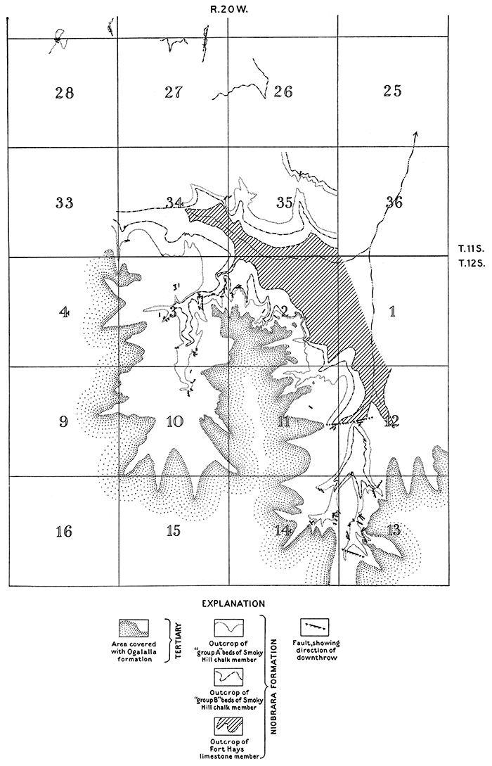
The fault of greatest magnitude noted in the tract examined in detail trends a little north of east near the common quarter corner of secs. 11 and 12, T. 12 S., R. 20 W. (Pl. IV). The beds are dropped on the south 80 feet, so that the top of the "group A" beds of the Smoky Hill member is brought into contact with rocks well below the top of the Fort Hays limestone member. Beds on the upthrown side dip at a low angle to the north, and those on the south dip 19° N., into the fault. Two faults, of parallel trend and of less than 5 feet displacement, occur just south of the large fault in the Smoky Hill member. It seems probable that the steep dip south of the large fault terminates in other faults now concealed by alluvium.
A few faults other than those shown on Plate IV were seen in Ellis County. The Fort Hays limestone member and the upper part of the Blue Hill member are cut by a fault trending N. 80° W., in which the beds are dropped 23 feet on the north near the southeast corner of sec. 25, T. 11 S., R. 19 W. The fault plane dips 60° N. The beds on both sides of the fault plane are essentially flat, and no vein calcite fills the fracture. Three parallel faults, trending N. 10° E., in each of which the beds are dropped a few feet on the west, appear in the Fairport member of the Carlile shale in the NW, sec. 29, T. 11 S., R. 16 W. Slickensided crystalline calcite veins fill these fractures. About 8 miles south of Hays, in the SE, sec. 17, T. 15 S., R. 18 W., the lower beds of the Fairport member are faulted. The fault strikes N. 60° E., and the beds are dropped 3 1/2 feet on the southeast. A vein of slickensided crystalline calcite 6 to 8 inches thick fills the fracture.
Of the eighty-one faults noted in the county, seventy-four were seen in the Smoky Hill chalk member of the Niobrara formation, three in the Fort Hays limestone member, and four in the Fairport member. As the seventy-four faults in the Smoky Hill member were found in the course of work that was far more detailed than that in the lower beds, the relation is probably not nearly so striking as here indicated. However, the evidence indicates that faults are more abundant in the Smoky Hill member than in the other members. Only one fault has an apparent throw greater than 25 feet. No system as to direction of fault planes is discernible, and the dips of the fault planes are steep. As a rule the fault planes are marked by slickensided vein calcite, and in some places the chalk beds near the fault plane on the down thrown side are intricately cut by thin calcite veins that are nearly vertical or dip slightly toward the fault plane. On the downthrown side of many but not all of the faults the beds dip into the fault plane.
Twenhofel has studied faults in the Niobrara formation at numerous localities in counties north and west of Ellis County and accounts for them under four possible methods of origin, as follows, stating that most of the faults are probably due to the cause first mentioned: (1) Settling of brittle chalk to conform to adjustments attending unequal compression of the thick body of shale over the irregularities of the Permian-Comanche unconformity and over sand lenses in the Comanche and Dakota; (2) surficial slumping on the slopes of present stream valleys; (3) slumping into solution cavities within the chalk; (4) faulting in conjunction with regional structural movement (Twenhofel, 1925).
Adjustments attending unequal compression of sediments. Observations made in Ellis County are not inharmonious with Twenhofel's conclusion that the greater number of these faults can be attributed to unequal compression of sediments over sand lenses in the Comanche and Dakota and irregularities in the Permian surface. Recent drilling has revealed another unconformity lying about 3,500 feet beneath the surface of Ellis County over which this process may have also operated to some extent. It has been pointed out by several writers that irregularities in such an old eroded land surface as that marked by this unconformity form cores over which the sediments are unequally compressed (Blackwelder, 1920; Mehl, 1920; Powers, 1922). the clay deposits for instance being more readily compactible than limestones and sandstones.
The chalk beds of the Niobrara formation are exceedingly brittle and are consequently susceptible to only slight deformation except by breaking. These brittle beds immediately overlie a deposit consisting predominantly of soft clay shale a little more than 400 feet thick, which is in turn underlain by the Dakota sandstone and Comanche beds which contain lenticular sand bodies, and overlie the irregularly eroded surface of the Permian rocks. This order of succession of beds appears to be ideal for securing faulting in the Niobrara chalk. The thick clay beds are compressed over the less compactible sandstone beds of the Dakota and Comanche and the less readily compactible beds of the Permian; and because of the lenticular character of the sand bodies and the irregularities in the Permian surface are compacted unequally. The chalk beds of the Niobrara formation, which overlie the clay body, because of their brittle character are not susceptible to adjustment by simple folding and bending to the irregularities thus formed, but instead the adjustment is accomplished by faulting. It seems that the irregularities at the top of the thick shale body resulting from such a process would likely be for the most part undulatory in type favoring the production of many faults accompanied by small displacement of the beds rather than a few breaks of great magnitude. The large number of faults with small displacement of the rocks found in Ellis County is in harmony with this hypothesis.
The presence of faults in the Greenhorn limestone which is separated from the Dakota sandstone by only about 40 feet of clay shale and is below much of the soft clay unit that immediately underlies the Niobrara beds suggests that the nucleus about which the settling has taken place to produce these faults (assuming this to be their origin), must lie well down in the Dakota or Comanche rocks, or below. It may be that the base over which this process of unequal compression has operated is in some cases even below the upper Permian surface, perhaps the old erosion surface that lies at a depth of about 3,500 feet.
An illustration of the general process of folding of soft beds accompanied by faulting in overlying brittle beds was seen in the field. The brittle chalk beds of "group A" beds of the Smoky Hill member are cut by a fault of small displacement which is resolved into a fold in the shales of the lower part of the group, in the NW of the SW, sec. 12, T. 12 S., R. 20 W., as illustrated in Figure 12.
Figure 12--A fault in chalk beds of "Group A" of the Smoky Hill member that grades into a fold in underlying shale. NW SW sec. 12, T. 12 S., R. 20 W.
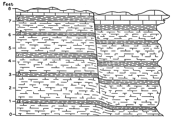
Surficial slumping. Although recent slumping of large blocks of Fort Hays limestone has occurred at many localities where erosion has been rapid and the limestone caps steep shale slopes, no evidence that this process has operated to cause any of the faults mapped in Ellis County was seen. Furthermore, in Ellis County no appreciable number of the fault blocks dip into the slope, which is the usual attitude assumed as the result of slumping of this character. However, the slope of the pre-Ogalalla surface may be quite different from the present slope and it is possible that a relationship between the faults and that slope might be established.
Slumping into solution cavities. If all the faults seen in the region are to be attributed to unequal compression of sediments, it should be expected that the Fort Hays limestone member of the Niobrara formation would contain as many faults as the overlying beds of the Smoky Hill member, as the Fort Hays is composed of brittle chalk with much less shale content than the Smoky Hill. Observations in the field, however, show that all but seven of the eighty-one faults observed are in the rocks of the Smoky Hill member, and that only three are in the Fort Hays limestone. However, the Smoky Hill member occupied the greater part of the surface of the area examined in detail for faults. A larger number of faults were seen in the "group A" beds of the Smoky Hill member than in the underlying "group B" beds. This difference suggests that the faults increase in number upward. Although the type of field mapping carried on did not permit the detection of all faults, the fact that the faults seen in the Smoky Hill member are much more numerous than those observed in the Fort Hays member indicates that all the faults in the Smoky Hill beds do not extend into beds in the Fort Hays, and that the causes operating to produce some of the faults in the Smoky Hill member did not similarly affect the Fort Hays member. The abundance. of calcite vein material filling the fault fractures indicates solution and redeposition of considerable material by circulating ground water within the Smoky Hill member. However, this might be expected in such readily soluble material as chalky limestone and shale, whatever the cause of the faults. The prevailing habit of the beds on the downthrown side of the faults to dip steeply into the fault planes suggests the former presence of cavities, the roofs of which have failed, allowing the overlying rocks to slump down. It is concluded, therefore, that some of the faults in the Smoky Hill member may have been formed in this manner.
Faults resulting from regional crustal deformation. If any appreciable number of the faults described were formed in connection with the structural deformation of the rocks of the region they would show more or less regularity as to habit or plan of occurrence, trend, direction of displacement, and distribution with relation to structure. Few data concerning their distribution with relation to the structure were obtained, but their utter lack of any regular plan, trend, and direction of displacement indicates that for the most part the faults are not related primarily to the structure of the region.
To summarize, no definite conclusion as to the origin of the faulting in this region can be drawn from the data at hand, but the evidence appears to suggest that most of the faults may be accounted for by unequal compression of sediments over buried irregularities on old erosion surfaces, or sand lenses; some by failure of roofs of cavities formed by circulating ground water within the Niobrara formation; a very few may be related to regional crustal deformation; and it is not impossible that a few may be the result of slumping into present stream channels.
Economic Products
At present the greatest interest in the mineral resources of Ellis County is centered on the possible presence of oil and gas, and if either should be found within the county it will for a time overshadow all other mineral products, but others, including building stone, gravel, cement, and salt are nevertheless important. The bentonitic clay beds mentioned in the stratigraphic description are too thin and impure to be of any economic value as a source of bentonite.
Oil and gas prospecting
In 1903 a well was drilled near the center of sec. 10, T. 15 S., R. 20 W. (Darton, 1905), in search of gas for use in mills that were being erected for the extraction of gold from the Carlile shale (Lindgren, 1902). No shows of gas or oil were recorded and the well stopped in the "Red Bed" at a depth of 1,177 feet. Artesian water was struck at several depths. Recently a well was drilled for oil in the northwest corner of sec. 14, T. 12 S., R. 16 W., 3 miles west of the Russell pool, on one of the most prominent of the minor anticlines of the county. Several good shows of oil were encountered, but the well was abandoned after testing rocks that lie about 300 feet below the producing horizon of the Fairport-Natoma anticline. A well drilled to a depth of about 3,500 feet on the Polifka farm, in sec. 18, T. 13 S., R. 17 W., found several shows of oil but failed to yield in commercial quantity. The Bemis well, drilled in 1925, in sec. 16, T. 11 S., R. 17 W., to a depth of 3,570 feet, struck several shows of oil and gas. A derrick is built in sec. 33, T. 15 S., R. 20 W. A well is being drilled in sec. 25, T. 10 S., R. 19 W., a little more than 2 miles north of the county boundary. A show of oil was obtained north of Ogallah, about 10 miles west of the county boundary, in sec. 9, T. 11 S., R. 22 W. Wells in Russell County, within a mile of the Ellis County line, are producing oil. A well drilled in the SW sec. 3, T. 16 S., R. 16 W., Rush county, less than 1 mile south of Ellis counts, on the Pfeifer anticline, found shows of oil but failed to obtain commercial quantities of oil. This anticline is similar to the Fairport-Natoma anticline, which produces oil in Russell County, in being steeper on the west flank than on the east, but the reconnaissance mapping (Pl. III) indicates that the area of westward dip is somewhat less extensive than that of the Fairport-Natoma fold.
The anticline in T. 11 S., R. 19 W., shown on Plate III, although less steeply folded, is believed to be a part of an extensive series of structural "highs" that extends northward from Ness county into Phillips county. This anticline is now being tested for oil and gas by wells that are being drilled north of Ellis County. A well drilled in 1925 in sec. 25, T. 10 S., R. 19 W., a little more than 2 miles north of the Ellis County boundary, is reported to have encountered two or more strong shows of oil. Other wells drilled farther north, in general alinement with this fold, have obtained shows of oil.
Building stone
Building stone is plentiful in Ellis County. The "fence-post limestone," the top bed of the Greenhorn limestone, has been extensively quarried along its outcrop in the southeast quarter of the county and used as fence posts, bridge stone, and building stone. Most of the large churches in the county are built of this stone. It is estimated that the present cost of fence posts at the quarry is about 50 cents each (Loreditsch, C. J., county engineer of Ellis County, personal communication). The Fort Hays limestone also has been used for building, although it is softer and weathers more rapidly than the "fence-post limestone." Several public buildings and numerous farm buildings have been constructed of the harder chalk beds of the Smoky Hill member of the Niobrara formation in counties west of Ellis. The chalk beds of the two members of the Niobrara formation appear to be useful for the manufacture of whiting, and the numerous thick exposures that lie directly along the Union Pacific railroad may in the course of time be so used.
Gravel
Gravel suitable for use in masonry, street paving, and road surfacing is abundant along the flood plains and higher terraces of the streams. Recently a large amount of gravel for street construction has been taken from the valley of Big Creek, about one mile west of Hays. Road materials are obtained from the Tertiary rocks in some localities in western Kansas, particularly from areas where the Tertiary gravel is cemented with silica so as to form a very hard quartzitic rock. Quartzitic tertiary rocks occur half a mile south of the southwest corner of the county, in sec. 6, T. 16 S., R. 20 W.
Cement
The raw ingredients for the manufacture of cement are abundant in Ellis County. The idle plant of one unsuccessful attempt to manufacture cement stands at Yocemento, on the Union Pacific Railroad. The history of this enterprise was not learned, but the remoteness from fuel and large markets must have contributed to its failure. The production of oil and gas near by solves the fuel problem in part, but the remoteness from large markets still remains.
Ground water
Although in parts of the county the principal water-bearing strata lie at considerable depth, little difficulty is experienced in obtaining ample water for stock, but potable water for domestic use is lacking in some places. Several wells drilled in Ellis County to the contact of the Fairport and Blue Hill members of the Carlile shale obtained potable water, and the Codell sandstone bed, forming the top of the Blue Hill member, also furnishes satisfactory supplies. On the High Plains excellent water is found in abundance in the Ogalalla formation. Along the larger stream valleys shallow water may be found in the gravel of the alluvium.
However, to obtain water in sufficient quantity for stock and of a quality suitable for domestic use is a real problem in much of the county. In areas lying below the outcrop of the. base of the Blue Hill member and away from the larger stream courses it is necessary to drill to the Dakota sandstone, which unfortunately in many places yields water that is too salty for domestic use. In many wells, however, the water in the uppermost water-bearing stratum of the Dakota is not so highly saturated with salts as that in the lower porous strata of the formation and can be used for domestic purposes.
Salt
The records of recent deep wells show that Ellis County, like most of the counties of western Kansas, is underlain by an enormous deposit of salt, ranging in total thickness from 21 feet as reported in the Bemis well, in sec. 16, T. 11 S., R, 17 W., to 230 feet in the Polifka and Smith wells, in sec. 18, T. 13 S., R, 17 W., and sec. 14, T. 12 S., R,16 W., respectively. These wells, together with others in Trego, Ness, Rush and Russell counties, furnish data for a calculation of the amount of salt underlying Ellis County. If it is assumed that 30 per cent of the salt thickness as reported by drillers is occupied by shale, mud, or other rocks than salt, that is, using but 70 per cent of the thickness actually reported in the well logs, and that the thickness of the salt beds varies at a uniform rate between the wells, a rough estimate indicates that Ellis County contains more than 200 billion tons of salt. Built in a prism standing upright, its base occupying one square mile, this quantity of salt would tower into the air about 2 miles. The top of the salt series lies approximately 1,400 feet below the surface in the eastern part of Ellis County and increases in depth westward (Fig. 11). As thick salt deposits lie nearer the surface farther east in Kansas and are therefore more easily accessible, the salt in Ellis County is only a potential resource and is of little economic value at present.
Prev Page--Contents || Next Page--Hamilton County
Kansas Geological Survey, Geology
Placed on web July 2, 2015; originally published April 1926.
Comments to webadmin@kgs.ku.edu
The URL for this page is http://www.kgs.ku.edu/Publications/Bulletins/11/02_ellis.html