![]()
Prev Page--Contents || Next Page--Classification
Introduction
Coal petrography is a branch of geology dealing with the constitution of coal as determined with the microscope. Investigations in this field of geology have contributed greatly to a better understanding of the nature of coal and have supplied much information concerning its origin and proper utilization. Since coal utilization has become increasingly important in modern technological processes, much attention has been devoted to studies of the relationship between the various chemical and physical properties of coal and the selection of the best coals for particular purposes. Coals do not, however, exhibit uniform chemical and physical properties even within a single bed. Petrographic studies have been invaluable in revealing the reasons for this lack of uniformity and have established correlation of chemical and physical properties with the constituents of coal as seen under the microscope.
As a coal state, Kansas ranks 16th in the nation, producing about $8,000,000 worth of coal annually. Most of the coals are thin and considerable overburden must be removed in mining them. It is therefore especially important that Kansas coals be utilized to best advantage. This report correlates detailed coal petrography with some physical and chemical properties of several selected commercial coals from southeastern Kansas.
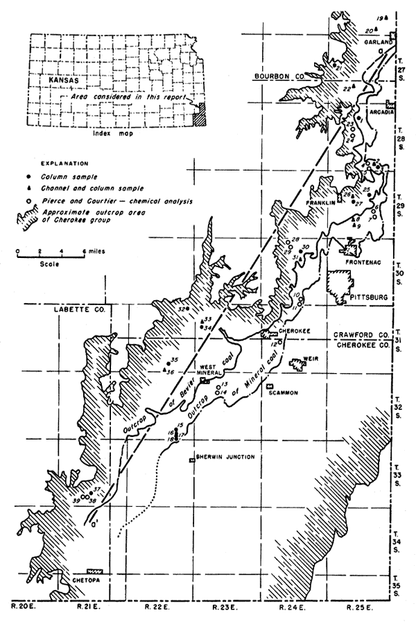
The Southeastern Kansas coal field (chiefly in Crawford and Cherokee Counties, but partly in Bourbon and Labette Counties) is the oldest and most important coal-mining area in Kansas. All the rocks exposed in this area belong to the Pennsylvanian System except for some Mississippian limestone in the southeast corner of Cherokee County. The coals occur in the Cherokee group of the middle Pennsylvanian Desmoinesian Series. The Cherokee group is defined (Moore, 1936, p. 55) to include strata between the upper unconformable surface of the Mississippian rocks and the base of the Fort Scott limestone. The average thickness of Cherokee rocks in southeastern Kansas is about 400 feet. The outcrop area is about 20 miles wide, extending northeast into Missouri and southwest into Oklahoma [Fig. 1]. Cherokee rocks are mainly clastic and consist of gray and black shales with lesser amounts of sandstone and a few thin beds of limestone.
Figure 1--Southeastern Kansas coal field, general geology, and sample locations. (Details concerning locations, numbered 1 through 39, are given in Table 5.)
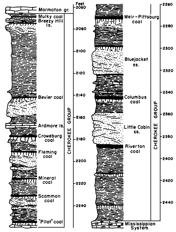
Of the 15 coal beds which have been identified (Abernathy, 1937) in the section (Fig. 2), the most economically important coals are the Weir-Pittsburg, Mineral, and Bevier. According to Abernathy, Jewett, and Schoewe (1947, p. 6), the Weir-Pittsburg is the thickest coal in the State and has had the largest total production. It lies 175 to 250 feet above the base of the Cherokee and dips northeastward about 20 feet to the mile. The Mineral coal (sometimes called the "Upper" Weir-Pittsburg) lies from 65 to 80 feet above the Weir-Pittsburg and is now the most actively mined coal in Kansas. The Bevier lies about 100 feet below the top of the Cherokee group and holds second position in current production.
Figure 12--Generalized columnar section showing coals of the Cherokee group (after Moore and others, 1951).
Scope of investigation--The Mineral and Bevier coals were selected for study because they are most actively mined at present and would therefore yield a better distribution of samples for petrographic analysis. Moreover, the results of the study would be of greater value to coal producers. One sample of Croweburg coal was included in the study because the sample was easily obtained in a strip mine where the Mineral coal also was sampled. Twenty-four column samples of coal were cut from fresh exposures in Crawford, Cherokee, Labette, and Bourbon Counties. The distribution of samples, determined largely by strip-mine activity, extends in a northwest-southeast belt from Garland to Sherwin Junction. At 11 localities, composite channel samples for chemical analysis were taken immediately adjacent to the column samples. The outcrop of the coals and the location of samples are shown on Figure 1.
Previous work--The first comprehensive report on Kansas coal, written by Haworth and Crane (1898), deals largely with the Southeastern Kansas coal field in its early stage of development. Young and Allen (1925) furnished information on engineering and production methods and included data from proximate and ultimate analyses and carbonization and distillation tests. Moore and Landes (1927) discussed the coal of southeastern Kansas in their report on the underground resources of Kansas. Pierce and Courtier (1938) published an excellent report on the geology and resources of the field and included a structural map on the Weir-Pittsburg coal and numerous chemical analyses. In the same year, Abernathy (1938) published on cyclothems in the Cherokee group. Subsequent publications have included a paper by Jewett and Schoewe (1942), a map of mined areas in the Weir-Pittsburg bed (Abernathy, 1944), a discussion of the strip-mined areas by Abernathy (1946), and a summary of the coal reserves in Kansas by Abernathy, Jewett, and Schoewe (1947). The State Geological Survey now has in preparation reports on the coal reserves of the Cherokee group and on the stratigraphy of these rocks.
Since 1942 the State Geological Survey has been engaged in a detailed inventory of all coal reserves in Kansas. Published reports on coals other than those in the Cherokee rocks include reports on coals of the Douglas group (Bowsher and Jewett, 1943), the Wabaunsee group (Schoewe, 1946), the Thayer bed (Schoewe, 1944), and the Permian rocks (Schoewe, 1951), and the lignite coal resources of the Cretaceous rocks of Kansas (Schoewe, 1952).
Acknowledgments--Appreciation is expressed to Robert M. Dreyer for his considerable help and critical reading of the manuscript and to Gilbert H. Cady (Illinois Geological Survey) and Bryan C. Parks (U. S. Bureau of Mines) for helpful suggestions and advice. I further wish to acknowledge the financial assistance of the Pittsburg and Midway Coal Mining Company, the Hume-Sinclair Coal Mining Company, and the Shell Oil Company. Chemical analyses were made under the supervision of Russell T. Runnels of the Kansas Geological Survey and Prescott Underwood and James Lammons assisted in the preparation of thin sections.
Prev Page--Contents || Next Page--Classification
Kansas Geological Survey, Geology
Placed on web November 2005; originally published May 1953.
Comments to webadmin@kgs.ku.edu
The URL for this page is http://www.kgs.ku.edu/Publications/Bulletins/102_1/02_intro.html