![]()
Prev Page--Preparation || Next Page--Petrography
Lithology and Chemical Composition of the Mineral, Croweburg, and Bevier Coals
Mineral Coal
Lithology--The Mineral coal is named from the town of Mineral in northwestern Cherokee County, where it has been mined extensively. The outcrop of the Mineral coal follows a generally northeast trend from a point 2 miles northwest of Sherwin Junction to a point west of Franklin where it turns north and parallels the State line until it swings into Missouri south of Garland. Column samples were collected at eight localities along this trend and, at three places, composite channel samples for chemical analysis were collected immediately adjacent to the column samples. The chemical analyses from these samples are supplemented by data from the analyses of Pierce and Courtier (1938, table 1.) On the map showing the location and distribution of samples (Fig. 1) the localities are numbered in sequence from northeast to southwest and all tabulated data are arranged in a similar manner for easy comparison. Table 5 gives the exact location of the samples.
Table 5--Location of samples. Sample types are designated as follows: A, Chemical analysis from Pierce and Courtier (1938 table 1); B, column sample; C, column sample and composite channel sample for chemical analysis.
| Locality no. |
Sample no. |
Sample Type |
Bed | County | Description |
|---|---|---|---|---|---|
| 1 | Cr-2-M | B | Mineral | Crawford | NE NE sec. 9, T. 28 S., R. 25 E.; abandoned strip mine |
| 2 | Cr-4-M | C | Mineral | Crawford | NE SW sec. 35, T. 28 S., R. 25 E., one-half mi. northwest Mulberry; strip mine, Palmer Coal Co. |
| 3 | Cr-3-M | B | Mineral | Crawford | Cen. sec. 35, T. 28 S., R. 25 E., one-half mi. northwest Mulberry; strip mine, Palmer Coal Co. |
| 4 | B-2659 | A | Mineral | Crawford | NE sec. 34, T. 28 S., R. 25 E.; abandoned strip mine, A. B. McKay Coal Co. |
| 5 | B-2660 | A | Mineral | Crawford | Near Cen. E. line sec. 34, T. 28 S., R. 25 E.; abandoned strip mine, A. B. McKay Coal Co. |
| 6 | B-2655 | A | Mineral | Crawford | SW sec. 23, T. 29 S., R. 25 E.; abandoned strip mine, Clemens Coal Co. No. 23 |
| 7 | B-2656 | A | Mineral | Crawford | SW sec. 23, T. 29 S., R. 25 E.; abandoned strip mine, Clemens Coal Co. |
| 8 | Cr-1-C | C | Croweburg | Crawford | SE NW sec. 28, T. 29 S., R. 25 E., 1 mi. north highway 160 at Frontenac; center of strip mine, Mackie Clemens Fuel Co. |
| 9 | Cr-8-M | C | Mineral | Crawford | SE SW sec. 28, T. 29 S., R. 25 E., 1 mi. north highway 160 at Frontenac; south end of strip mine, Mackie Clemens Fuel Co. |
| 10 | B-2665 | A | Mineral | Crawford | SW sec. 34, T. 30 S., R. 24 E.; abandoned strip mine, Pittsburg-Midway No. 17 |
| 11 | B-2666 | A | Mineral | Crawford | SW sec. 34, T. 30 S., R. 24 E.; abandoned strip mine, Pittsburg-Midway No. 17 |
| 12 | B-2652 | A | Mineral | Cherokee | 700 ft. west, 15 ft. south of NE cor. sec. 20, T. 31 S., R. 24 E.; abandoned strip mine, Commercial Fuel No. 2 |
| 13 | B-2667 | A | Mineral | Cherokee | SW NW sec. 9, T. 32 S., R. 23 E.; abandoned strip mine, Pittsburg-Midway No. 15 |
| 14 | B-2668 | A | Mineral | Cherokee | NW sec. 9, T. 32 S., R, 23 E.; abandoned strip mine, Pittsburg-Midway No. 15 |
| 15 | Ck-5-M | B | Mineral | Cherokee | NE NW sec. 35, T. 32 S., R. 22 E., active strip mine, Pittsburg-Midway No. 15 |
| 16 | Ck-4-M | C | Mineral | Cherokee | SE NW sec. 35, T. 32 S., R. 22 E., 21/2 mi. north Sherwin Junction; active, Pittsburg-Midway No. 15 |
| 17 | Ck-3-M | B | Mineral | Cherokee | SE SW sec. 35, T. 32 S., R. 22 E.; active, Pittsburg-Midway No. 15 |
| 18 | Ck-2-M | B | Mineral | Cherokee | SE SW sec. 35, T. 32 S., R. 22 E.; 300 yds. south of Ck-3-M, active Pittsburg-Midway No. 15 |
| 19 | Bn-3-B | C | Bevier | Bourbon | SW NW sec. 25, T. 26 S., R. 25 E.; 1.7 mi. north Kansas highway 7 at Garland; custom strip mine |
| 20 | Bn-2-B | C | Bevier | Bourbon | SE NW sec. 35, T. 26 S., R. 25 E., 1 mi. northwest Garland; active strip mine, Kelly-Carter Coal Co. |
| 21 | Bn-1-B | B | Bevier | Bourbon | NW SE sec. 18, T. 27 S., R. 25 E., west of highway 69, 1.3 mi. north of Crawford Co. line, custom strip mine, Pellet Coal Co. |
| 22 | Cr-9-B | C | Bevier | Crawford | SW NE sec. 28, T. 27 S., R. 25 E., active strip mine, Pryor Coal Co. |
| 23 | B-2669 | A | Bevier | Crawford | Cen. S. line NW sec. 16, T. 28 S., R. 25 E., abandoned strip mine, Pioneer Coal Co. |
| 24 | B-2670 | A | Bevier | Crawford | Near Cen. SW sec. 16, T. 28 S., R. 25 E.; abandoned strip mine. Pioneer Coal Co. |
| 25 | Cr-5-B | C | Bevier | Crawford | NW NE sec. 15, T. 29 S., R. 25 E., 2.7 mi. west Franklin; active strip mine, Mackie Clemens Fuel Co. |
| 26 | Cr-6-B | C | Bevier | Crawford | SE NW sec. 16, T. 29 S., R. 25 E., 1.5 mi. east Franklin; active strip mine, Mackie Clemens Fuel Co. |
| 27 | Cr-7-B | B | Bevier | Crawford | NE SW sec. 16, T. 29 S., R. 25 E., 1.2 mi. east Franklin; active strip mine, Mackie Clemens Fuel Co. |
| 28 | B-2658 | A | Bevier | Crawford | Sec. 4, T. 30 S., R. 24 E., abandoned strip mine, Eagle-Cherokee Coal Mining Co. |
| 29 | B-2657 | A | Bevier | Crawford | SE sec. 4, T. 30 S., R. 24 E., abandoned strip mine, Eagle-Cherokee Coal Mining Co. |
| 30 | Cr-12-B | B | Bevier | Crawford | NW NE sec. 10, T. 30 S., R. 24 E., 3.5 mi. west Frontenac; active strip mine, Eagle-Cherokee Coal Mining Co. |
| 31 | Cr-14-B | C | Bevier | Crawford | NE SW sec. 10, T. 30 S., R. 24 E., active strip mine, Eagle-Cherokee Coal Mining Co. |
| 32 | Cr-11-B | B | Bevier | Crawford | SE NW sec. 1, T. 31 S., R. 22 E., 1 mi. northwest Monmouth; active strip mine, Lightening Creek Coal Co. |
| 33 | Cr-13-B | C | Bevier | Crawford | NW SE sec. 7, T. 31 S., R. 23 E., 0.75 mi. southeast Monmouth; active strip mine, Apex Coal Co. |
| 34 | Cr-10-B | B | Bevier | Crawford | SW SE sec. 7, T. 31 S., R. 23 E., 400 yds. south of Cr-13-B, active strip mine, Apex Coal Co. Cherokee |
| 35 | Ck-1-B | B | Bevier | Cherokee | SE NE sec. 34, T. 31 S., R. 22 E., 4 mi. northwest Mineral; active strip mine, Pittsburg-Midway No. 18 |
| 36 | Ck-6-B | C | Bevier | Cherokee | NW SE sec. 34, T. 31 S., R. 22 E., 4 mi. northwest Mineral; active strip mine, Pittsburg-Midway No. 18 |
| 37 | Lt-1-B | B | Bevier | Labette | SW SW sec. 27, T. 33 S., R. 21 E., active strip mine, Gallagher Coal Co. |
| 38 | B-2664 | A | Bevier | Labette | NE sec. 33, T. 33 S., R. 21 E., abandoned strip mine, Vanduker Coal Co. |
| 39 | B-2663 | A | Bevier | Labette | NE sec. 33, T. 33 S., R. 21 E., abandoned strip mine, Vanduker Coal Co. |
The coal is obtained from strip mines with an overburden of about 20 feet of dark-gray to black shale. In some places, the coal is capped by a discontinuous dark-gray fossiliferous limestone which locally thickens and cuts out the coal as at the Mackie-Clemens operation (Loc. 9, Fig. 1).
The thickness of the Mineral coal averages 15.2 inches, ranging from 10.4, to 21.1 inches. Pierce and Courtier (1938, p. 71) indicate that the limits are between 17 and 24 inches but it is apparent that these thicknesses include several inches of bone or shaly coal which is characteristically present at the top of the bed. This material is usually removed in mining operations and should not be included as coal.
The Mineral coal is a typical, finely banded, attrital coal. Wide anthraxylon bands are scarce and seldom exceed 1 mm in thickness. Megascopic fusain is readily observable, but randomly distributed. The fusain is usually concentrated at several horizons in any particular sample, but appears lenticular. It is found at a different horizon in adjacent samples. Vertical butt and face cleats as well as other fractures are filled with calcite which partially accounts for the unusually high ash content. The calcite acts as a binder permitting the mining of large lumps which would otherwise fall into smaller sizes. Much pyrite is present in nodules and lenticular bodies parallel to the bedding. The coal at the south end of the field is of particular interest because of these pyrite nodules and associated "coal balls." "Coal balls" have been found principally in the Pittsburg-Midway No. 15 mine (Locs. 15, 16, 17, 18, Fig. 1) where they always occur in the upper 6 inches of the coal. This subject is discussed further under "Mineral Matter in Coal."
Chemical composition and rank--Proximate chemical analyses of 12 samples of Mineral coal are tabulated in Table 6 as determined by the method of Stanton, Fieldner, and Selvig (1939). For purposes of comparison, all analyses have been calculated to the moisture and ash-free basis and are so designated in the following discussion unless otherwise stated. This has been done for several reasons: (1) some of the samples were analyzed after air drying so that the actual bed moisture is not known, and (2) irregularities due to variable ash content are eliminated and the actual coal material may be compared.
Table 6--Chemical analyses of coal from the Southeastern Kansas coal field. The form of analysis is denoted as follows: a, as received at the laboratory; b, air dried; c, moisture free; d, moisture and ash free. **Analyses from Pierce and Courtier (1938, table 1).
| Locality | Sample no. |
Condition | Moisture | Volatile | Fixed Carbon |
Ash | Sulfur | Calorific value B.t.u. |
Mineral matter-free basis | ||
|---|---|---|---|---|---|---|---|---|---|---|---|
| Moist B.t.u. |
Dry fixed carbon |
Rank | |||||||||
| Mineral Coal | |||||||||||
| 2 | Cr-4-M | b | 1.5 | 32.1 | 50.2 | 16.3 | 6.2 | 11,960 | |||
| c | 32.6 | 51.0 | 16.5 | 6.3 | 12,140 | ||||||
| d | 39.0 | 61.0 | 10.8 | 14,540 | |||||||
| 4 | B-2659** | a | 4.8 | 33.9 | 49.5 | 11.8 | 3.5 | 12,530 | 14,510 | 60.8 | High vol. A bituminous |
| c | 35.6 | 52.1 | 12.3 | 3.7 | 13,150 | ||||||
| d | 40.6 | 59.4 | 4.2 | 15,010 | |||||||
| 5 | B-2660** | a | 4.3 | 34.3 | 40.8 | 13.4 | 4.6 | 12,300 | 14,560 | 66.2 | High vol. A bituminous |
| c | 35.8 | 50.2 | 14.0 | 4.8 | 12,850 | ||||||
| d | 41.6 | 58.4 | 5.6 | 14,940 | |||||||
| 6 | B-2655** | a | 4.4 | 34.2 | 48.8 | 12.6 | 4.8 | 12,420 | 14,550 | 61.0 | High vol. A bituminous |
| c | 35.8 | 51.0 | 13.2 | 5.1 | 13,000 | ||||||
| d | 41.3 | 58.7 | 5.8 | 14,960 | |||||||
| 7 | B-2656** | a | 5.1 | 34.7 | 48.7 | 11.5 | 3.6 | 12,490 | 14,360 | 59.8 | High vol. A bituminous |
| c | 36.6 | 51.3 | 12.1 | 3.8 | 13,160 | ||||||
| d | 41.6 | 58.4 | 4.4 | 14,970 | |||||||
| 9 | Cr-8-M | b | 1.1 | 33.9 | 51.5 | 13.6 | 4.3 | 12,910 | |||
| c | 34.3 | 52.1 | 13.8 | 4.3 | 13,050 | ||||||
| d | 39.7 | 60.3 | 5.0 | 15,140 | |||||||
| 10 | B-2665** | a | 4.4 | 33.5 | 45.7 | 16.4 | 3.3 | 11,930 | 14,610 | 59.2 | High vol. A bituminous |
| c | 35.1 | 47.7 | 17.2 | 3.5 | 12,480 | ||||||
| d | 42.4 | 57.6 | 4.2 | 15,080 | |||||||
| 11 | B-2666** | a | 4.0 | 35.8 | 49.3 | 10.9 | 3.9 | 12,690 | 14,500 | 59.2 | High vol. A bituminous |
| c | 37.3 | 51.3 | 11.4 | 4.0 | 13,220 | ||||||
| d | 42.1 | 57.9 | 4.6 | 14,920 | |||||||
| 12 | B-2652** | a | 5.1 | 33.2 | 46.8 | 14.9 | 3.6 | 12,060 | 14,520 | 60.0 | High vol. A bituminous |
| c | 35.0 | 49.3 | 15.7 | 3.8 | 12,710 | ||||||
| d | 41.5 | 58.5 | 4.5 | 15,080 | |||||||
| 13 | B-2667** | a | 3.6 | 34.3 | 50.5 | 11.6 | 3.4 | 12,870 | 14,850 | 61.5 | High vol. A bituminous |
| c | 35.5 | 52.5 | 12.0 | 3.5 | 13,350 | ||||||
| d | 40.4 | 59.6 | 4.0 | 15,160 | |||||||
| 14 | B-2668** | a | 2.9 | 35.1 | 51.5 | 10.5 | 2.8 | 13,110 | 14,950 | 60.5 | High vol. A bituminous |
| c | 36.2 | 53.0 | 10.8 | 2.9 | 13,510 | ||||||
| d | 40.6 | 59.4 | 3.2 | 15,140 | |||||||
| 16 | Ck-4-M | b | 1.1 | 38.7 | 48.2 | 12.0 | 4.5 | 12,910 | |||
| c | 39.1 | 48.7 | 12.1 | 4.6 | 13,050 | ||||||
| d | 44.5 | 55.4 | 5.2 | 14,850 | |||||||
| Bevier Coal | |||||||||||
| 19 | Bn-3-B | b | 1.4 | 34.4 | 49.9 | 14.2 | 8.8 | 12,570 | |||
| c | 34.9 | 50.6 | 14.4 | 8.9 | 12,750 | ||||||
| d | 40.8 | 59.1 | 10.4 | 14,890 | |||||||
| 20 | Bn-2-B | b | 1.3 | 35.8 | 47.0 | 16.0 | 2.8 | 11,820 | |||
| c | 36.3 | 47.6 | 16.2 | 2.8 | 11,980 | ||||||
| d | 43.3 | 56.8 | 3.3 | 14,300 | |||||||
| 22 | Cr-9-B | b | 1.1 | 36.8 | 52.1 | 10.0 | 2.5 | 13,910 | |||
| c | 37.2 | 52.6 | 10.1 | 2.5 | 14,060 | ||||||
| d | 41.4 | 58.5 | 2.8 | 15,640 | |||||||
| 23 | B-2669** | a | 3.4 | 37.6 | 50.6 | 8.4 | 2.8 | 13,250 | 14,650 | 58.4 | High vol. A bituminous |
| c | 38.9 | 52.4 | 8.7 | 2.9 | 13,720 | ||||||
| d | 42.6 | 57.4 | 3.1 | 15,030 | |||||||
| 24 | B-2670** | a | 4.6 | 36.9 | 48.6 | 9.9 | 2.4 | 12,940 | 14,570 | 57.5 | High vol. A bituminous |
| c | 38.7 | 51.0 | 10.3 | 2.5 | 13,570 | ||||||
| d | 43.1 | 56.9 | 2.8 | 15,140 | |||||||
| 26 | Cr-6-B | b | 1.4 | 35.1 | 50.3 | 13.2 | 2.7 | 13,310 | |||
| c | 35.6 | 51.0 | 13.4 | 2.7 | 13,500 | ||||||
| d | 41.1 | 58.9 | 3.1 | 15,590 | |||||||
| 28 | B-2658** | a | 3.4 | 34.3 | 49.6 | 12.7 | 2.4 | 12,700 | 14,860 | 60.3 | High vol. A bituminous |
| c | 35.5 | 51.3 | 13.2 | 2.5 | 13,150 | ||||||
| d | 40.9 | 59.1 | 2.9 | 15,140 | |||||||
| 29 | B-2657** | a | 4.3 | 35.4 | 46.4 | 13.9 | 2.3 | 12,280 | 14,580 | 58.0 | High vol. A bituminous |
| c | 36.9 | 48.6 | 14.5 | 2.4 | 12,830 | ||||||
| d | 43.2 | 56.8 | 2.8 | 15,010 | |||||||
| 31 | Cr-14-B | b | 1.1 | 35.0 | 47.2 | 16.7 | 4.2 | 12,250 | |||
| c | 35.4 | 47.7 | 16.9 | 4.2 | 12,380 | ||||||
| d | 42.6 | 57.4 | 5.1 | 14,900 | |||||||
| 33 | Cr-13-B | b | 1.4 | 35.1 | 47.9 | 15.6 | 2.7 | 12,290 | |||
| c | 35.6 | 48.6 | 15.8 | 2.7 | 12,460 | ||||||
| d | 42.3 | 57.7 | 3.2 | 14,800 | |||||||
| 36 | Ck-6-B | b | 1.5 | 36.3 | 45.1 | 17.2 | 4.2 | 11,340 | |||
| c | 36.9 | 45.8 | 17.5 | 4.3 | 11,510 | ||||||
| d | 44.7 | 55.5 | 5.2 | 13,950 | |||||||
| 38 | B-2664** | a | 3.5 | 42.0 | 48.6 | 5.9 | 3.1 | 13,660 | 14,720 | 59.7 | High vol. A bituminous |
| c | 43.5 | 50.4 | 6.1 | 3.2 | 14,150 | ||||||
| d | 46.3 | 53.7 | 3.4 | 15,070 | |||||||
| 39 | B-2663** | a | 3.7 | 40.8 | 47.7 | 7.8 | 3.1 | 13,330 | 14,700 | 55.0 | High vol. A bituminous |
| c | 4.2 | 49.5 | 8.1 | 3.2 | 13,850 | ||||||
| d | 46.1 | 53.9 | 3.5 | 15,070 | |||||||
| Croweburg Coal | |||||||||||
| 8 | Cr-1-C | b | 0.9 | 35.3 | 49.0 | 14.8 | 7.3 | 11,450 | |||
| c | 35.6 | 49.4 | 14.9 | 7.4 | 11,550 | ||||||
| d | 41.8 | 58.0 | 8.7 | 13,570 | |||||||
The average fixed carbon content is 58.7 percent and the coal has an average calorific value of 14,980 B.t.u. Sulfur is high, averaging 5.1 percent. The ash is unusually high, averaging 13.4 percent on the moisture-free basis. However, comparison of the analyses indicates that the coal is remarkably uniform in composition over a large area. With the exception of one sample, the calorific values do not differ from the average by more than several hundred B.t.u. and the fixed carbon values are within a few percent of the average. Sulfur and ash are somewhat more variable, as might be expected. The chemical analyses for which the bed moisture is known have also been calculated to the mineral-matter-free basis so that the coal could be classified according to A.S.T.M. rank designation (Table 1). Rank designation is determined by moist mineral-matter-free B.t.u. and dry mineral-matter-free fixed carbon according to the Parr (1928) equations as follows:
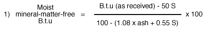
These equations result from efforts to increase the ash value to represent the original quantity of mineral matter present in the raw coal.
The mineral-matter-free tabulations of Table 6 indicate that the Mineral coal is a high volatile A bituminous coal according to the A.S.T.M. classification.
Although no coking tests on the coal were made, the agglomerating index was determined as described by Stanton, Fieldner, and Selvig (1939, pp. 36-37). The agglomerating index (Table 7) indicates the coking and caking properties of bituminous coal and is found by examination of the residue left in the platinum crucible from the volatile matter determination. It is of limited value for indicating coking properties since the coal is heated much more rapidly than that coked in commercial ovens. Thus, coals that yield good cokes in commercial practice always give well-coked residues from the volatile-matter determination, but the reverse is not always true. As shown in Table 8, the Mineral coal is classed as Cg or Cf, which means that it is a good to fair caking agglomerate coal--e.g., it will produce a button showing medium to strong swelling and good cell structure, has a characteristic metallic lustre, and generally will support a 500 gram weight. The buttons barely meet the 500 gram weight requirement since the cell walls tend to be thin and are easily crushed although the button supports the weight. It is doubtful that the coal would make good metallurgical grade coke since it is not particularly strong and has a high sulfur content which is 3 to 4 percent higher than the maximum tolerance of 1.5 percent sulfur.
Table 7--Agglomerating and coking properties of coals based on examination of residue incident to the volatile-matter determination (Stanton, Fieldner, and Selvig, 1939, p. 37)
| Designation | Appearance of residue from standard method for determination of volatile matter in coal | |
|---|---|---|
| Class | Group | |
| Nonagglomerating (button shows no swelling or cell structure and will not support 500 g without pulverizing) | NA (nonagglomerate) | NAa--noncoherent residue |
| NAb--coke button shows no swelling or cell structure and after removal from crucible will pulverize under a weight of 500 grams | ||
| Agglomerating (button shows swelling or cell structure or will support 500 g without pulverizing) | A (agglomerate) button dull black and sintered; shows no swelling or cell structure | Aw (weak agglomerate)--buttons come out of crucible in more than one piece |
| Af (firm agglomerate)--buttons come out of crucible in one piece | ||
| C (caking) shows swelling or cell structure | Cp (poor caking)--button shows slight swelling with small cells; has slight gray luster | |
| Cf (fair caking)--button shows medium swelling and good cell structure; has characteristic metallic luster | ||
| Cg (good caking)--button shows strong swelling and pronounced cell structure, with numerous large cavities and cells; has a characteristic metallic luster | ||
Table 8--Agglomerating index from volatile matter residue from Kansas coal
| Sample | Coal | Agglomerating index |
Support 500 grams |
|---|---|---|---|
| Bn-3-B | Bevier | Cf | Yes |
| Bn-2-B | Bevier | Cg | Yes |
| Cr-9-B | Bevier | Cg | Yes |
| Cr-6-B | Bevier | Cf | Yes |
| Cr-14-B | Bevier | Cg | Yes |
| Cr-13-B | Bevier | Cg | Yes |
| Ck-6-B | Bevier | Cf | Yes |
| Cr-4-M | Mineral | Cf | Yes |
| Cr-8-M | Mineral | Cg | Yes |
| Ck-4-M | Mineral | Cg | Broke in several pieces |
| Cr-1-C | Croweburg | Cg | Yes |
Bevier Coal
Lithology--The Bevier coal lies just above the Ardmore limestone and its outcrop is practically coincident with that of the Ardmore. It roughly parallels the Mineral coal beginning at a point several miles southeast of Oswego and continuing northeasterly until it crosses the State line into Missouri north of Garland.
Column samples were collected at 14 localities along the outcrop in strip mines and at 7 places composite channel samples for chemical analysis were collected immediately adjacent to the column samples. The chemical analyses are supplemented by data from Pierce and Courtier (1938, table 1).
The Bevier coal lies 80 to 100 feet below the top of the Cherokee shale and is mined from strip pits having an overburden of 25 to 30 feet of dark-gray to black shale. The shale may contain several beds of dark shaley limestone ranging from 2 to 30 inches in thickness. These thin limestones are most prominent in the northern part of the field. Locally, as much as 50 feet of overburden may be removed. A typical underclay is found immediately below the coal and this is, in turn, underlain by the Ardmore limestone.
The average thickness of the coal where sampled is 14.7 inches; its thickness ranges from 12 to 17.5 inches. Like the Mineral coal, it is finely attrital with few anthraxylon bands exceeding a thickness of 1 mm. It contains numerous megascopic lenses of fusain. It also contains many vertical calcite-filled fractures which are even more prominent than in the Mineral coal and probably account for the higher ash content of the Bevier. Pyrite nodules are not so numerous and the coal consequently has a lower sulfur content.
There is some evidence of structural deformation in the Bevier. At least four faults were encountered in the Pryor Coal Company operation at the north end of the field northwest of Arcadia (Loc. 22, Fig. 1). The faults had an east-west strike and dipped steeply to the south. Vertical displacement was about 2 feet so that the coal had to be mined at several levels. The coal also had a rolling or gently folded surface.
Chemical composition and rank--Chemical analyses of 13 samples of Bevier coal are listed in Table 6. The average fixed carbon content is 57.1 percent and the average calorific value is 14,690 B.t.u. Sulfur averages 3.9 percent and the ash is 17.7 percent on the moisture-free basis. In comparison with averaged Mineral coal analyses (Table 6) the Bevier is lower in calorific value, fixed carbon, and sulfur but higher in ash. The differences are not large but may be an indication of the operation of Hilt's law, which predicts that stratigraphically lower coals have higher fixed carbon (lower volatile) and calorific values due to increasing pressure and temperature rather than initial differences in the coal materials.
Comparison of individual Bevier analyses shows that the coal does not exhibit quite the same areal uniformity as does the Mineral. Although fixed carbon values have a range of about 5 percent and deviate from the average by only a few percent, the calorific values are quite variable and range from 13,950 to 15,640 B.t.u.
Chemical analyses calculated to the mineral-matter-free basis classify the Bevier coal as a high volatile A bituminous coal according to A.S.T.M. rank designation.
The agglomerating index is given for seven samples in Table 8. The Bevier is an agglomerate Cf to Cg or good to fair caking coal and exhibits approximately the characteristics of the Mineral coal. Although the lower sulfur content would make it more desirable as a domestic coke, the sulfur is still above the limit of 1.5 percent set for metallurgical coke.
Croweburg Coal
Lithology--The Croweburg coal is named from the town of Croweburg in northeastern Crawford County, where it was mined extensively at one time. It lies about 25 feet above the Mineral coal between the Mineral and Bevier so that its outcrop is between and roughly parallel to these coals. Only a small quantity of Croweburg coal is produced at the present time and good exposures are rare.
A column sample with an adjoining composite sample for chemical analysis was collected at the Mackie Clemens strip mine (Loc. 8, Fig. 1) where both the Mineral and Croweburg coals are mined in a single-operation. The Fleming coal also is exposed in the same mine but is so thin and of such poor quality that is rejected as refuse.
About 12 feet of shale overlies the Croweburg. It is dark gray at the base and grades upward into a lighter gray color. The top consists of about 3 feet of black fissile shale containing numerous concretions and phosphate nodules.
The coal is about 12 inches thick at the locality where sampled. Pierce and Courtier (1938, p. 75) report that this thickness is average for the bed. It is a finely attrital coal with few wide anthraxylon bands and several distinct layers of fusain.
Chemical composition and rank--Average analyses of the Croweburg coal are not available so that its chemical composition is reported here from a single determination (Table 6) which may not be representative. At a single locality, the coal has a fixed carbon content of 58.0 percent, an ash content of 14.9 percent, and a calorific value of 13,570 B.t.u. Sulfur comprised 8.7 percent on a moisture-free basis. It is roughly comparable to the Mineral coal (Table 6) although the calorific value is considerably lower.
The "as received" analysis has not been converted to the mineral-matter-free basis for purposes of rank designation because the bed moisture is not known. However, rough approximation indicates that the calorific value would fall between 13,000 and 14,000 B.t.u. and that fixed carbon would be less than 69 percent so that the coal is probably high volatile B bituminous.
The agglomerating index (Table 8) rates the coal as an agglomerate Cg or good caking coal. However, the sulfur content is far too high for metallurgical purposes.
Regional Variation in Chemical Properties
A knowledge of the regional variation in coal is of considerable importance to the producer since it enables him to predict the quality of his product in new ventures or in the extension of old fields. The chemical analyses of the Mineral and Bevier coals have shown that the Mineral is relatively uniform along the strike and that the Bevier is somewhat more variable. Variations in fixed carbon and volatile matter are commonly regarded as an indication of the stage of coalification or rank. Calorific variations arise in the same manner but may be a more sensitive index of coal type variation since the calorific value of hydrogen is greater than that of carbon.
The possibility that a small systematic variation might be discernible in the raw data resulted in the plot of fixed carbon and calorific value versus distance as shown in Figure 4. The Mineral and Bevier sample locations have been projected to the line a-a' of Figure 1.
Figure 4--Regional variation of fixed carbon and B.t.u. values inMineral and Bevier coals. Numbers refer to locations projected to line a-a', Fig. 1. A larger version of this figure is available.
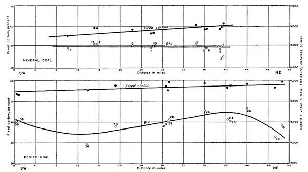
There are not a sufficient number of plotted points to define clearly regional variation but smooth curves which have been drawn at least suggest that the fixed carbon content of both coals increases from south to north. The calorific value of the Mineral coal is so uniform that the curve has almost no slope whereas the calorific value of the Bevier shows relatively wide variation.
Interpretation of these curves is speculative, but is considered in order to indicate the results which might be expected with a greater number and wider distribution of samples.
The Cherokee basin, in which coal accumulation took place, came into existence after Mississippian time. It was bounded on the north by the Bourbon arch which separated it from the Forest City basin. Within the basin are several known or inferred structural elements. Pierce and Courtier (1938, p. 53) have described the northwest-trending Pittsburg anticline and Dreyer (1947) has shown the probable existence of additional features through geophysical investigation. Since it has been demonstrated that the increased temperatures and pressures which accompany orogenic activity may produce an increase in the rank of coal, the effect of the above structural elements should be considered.
Little is known of the orogenic activity during Cherokee time. Nevertheless, tentative suggestion is made that activity of the Bourbon arch may have accounted for the increase in fixed carbon from south to north. One line of evidence lies in the structure of the Bevier coal mentioned earlier. Four faults were described at the north end of the field. These faults roughly parallel the Bourbon arch and may have been produced by movement of the arch.
However, at least part of the variation is probably due to analytical technique. The Bureau of Mines (Stanton, Fieldner, and Selvig, 1939, p. 59) permits difference of 0.5 percent for two volatile-matter determinations made in the same laboratory and 1.0 percent for determinations made in different laboratories. The fixed carbon tolerances should therefore be of the same order of magnitude. Differences of 0.3 and 0.5 percent are allowed for two calorific determinations made in the same laboratory and in different laboratories respectively. The overall differences between maximum and minimum values for the Mineral and Bevier coals are more of the order of 5 percent. Some part of this variation is systematic, but some is undoubtedly analytical.
Prev Page--Preparation || Next Page--Petrography
Kansas Geological Survey, Geology
Placed on web November 2005; originally published May 1953.
Comments to webadmin@kgs.ku.edu
The URL for this page is http://www.kgs.ku.edu/Publications/Bulletins/102_1/05_lith.html