![]()
Prev Page--Rocks Exposed, Mesozoic || Next Page--Structure
Rocks Exposed, continued
Mesozoic, continued
Cretaceous, continued
Greenhorn Limestone
Below the Carlile shale lie about 100 feet of beds of hard chalk and chalky marl, which constitute the Greenhorn limestone. This formation crops out on both sides of the valleys of the tributaries of the three large streams that run eastward across Russell County--Smoky Hill and Saline rivers and Wolf creek. Hard chalk in beds less than a foot thick alternate with chalky shale in the upper three-fourths of the formation. The proportion of chalk to marl is highest about one-fourth way down from the top. The lower fourth of the formation contains, in addition to the chalk and chalky shale, thin beds of hard crystalline limestone. From several measurements it seems that the thickness of the Greenhorn formation decreases from 105 or 110 feet in the northern part of Russell County south-southeastward to 85 or 90 feet in the southern part.
The great abundance of the fossil Inoceramus labiatus, the stratigraphic position, and the calcareous composition of the formation permits a close correlation of the formation with the Greenhorn limestone of parts of Colorado, Wyoming and elsewhere. [J. B. Reeside, Jr.; personal communication.] The name Greenhorn was given by Gilbert," in 1896, to corresponding beds in southern Colorado, which are typically exposed at Greenhorn station and on Greenhorn creek, south of Pueblo, Colo. [Gilbert, G. K.; The underground waters of the Arkansas Valley in eastern Colorado: U. S. Geol. Survey, Seventeenth Ann. Rept., pt. 2, p. 564; 1896.] The formation in Russell County, Kansas, is divisible into four members, here listed in descending order: (1) An upper unnamed member consisting of beds of chalky shale and fossiliferous chalk; (2) the Jetmore chalk member, which consists of regularly alternating beds of chalk and chalky shale; (3) an unnamed member of chalky shale containing few beds of chalk; and (4) the Lincoln limestone member, consisting of thin beds of crystalline limestone in a series of beds of chalk and chalky shale.
Upper member--The upper 20. feet of the Greenhorn limestone in Russell County is a chalky shale containing three beds of chalk, 4 to 10 inches thick. The uppermost one--the top bed of the member and of the formation--is the justly famous "fence-post limestone" or "post rock" of the farmers of western Kansas. It is a rather hard, slightly sandy, fairly coarse but even-grained and massive chalk that maintains a thickness of 8 or 9 inches. Where it lies under cover it is softer. On fresh surfaces the rock is dark gray, but it weathers to a light yellow gray or cream and shows a prominent rusty median line. It contains relatively few fossils. The rock, which is nearly free from joints, is easily split with wedges to desired shapes, and so it is widely used as building stone, bridge masonry, fence posts, and even telephone poles throughout the Greenhorn area in western Kansas; in fact, in this nearly treeless region wooden posts are rarely seen, and at nearly every outcrop of this bed in Russell County the rock has been quarried to some extent for these uses.
The 8 or 9 feet of soft, chalky, slightly gritty shale below the "fence-post limestone" contains several layers of thin, flat, rather inconspicuous concretions. Beneath these beds of marl lies a layer of hard, iron-stained chalk, 5 inches thick, which contains many Inoceramus shells. Below the middle chalk lies 5 feet of chalky shale, which is in turn underlain by a zone 2 1/2 feet thick of thin, highly fossiliferous concretionary chalk beds. In the southeast quarter of sec. 25, T. 15 S., R. 17 W., Ellis County, an elongate. chalk concretion with a coarsely crystalline core of barite a few inches in diameter and several feet long was found at this horizon. The basal 4 feet of the member is chalky shale. Analysis of a sample of the marl shows that about 55 per cent of it by weight is insoluble silty material containing small flakes of muscovite. The thickness of this member in Russell County is nearly constant. Apparently it increases southward from 19 to 21 feet.
Jetmore chalk member--The group of alternating thin beds of chalk and chalky shale that occupy the interval from 20 to 40 feet below the top of the Greenhorn formation is the Jetmore chalk member. The uppermost bed of this group--the "Inoceramus limestone" or "shell bed" of oil geologists--is a hard, thin-bedded to massive, very fossiliferous fine-grained chalky limestone, which within narrow limits of variation is about a foot thick. It is a light buff gray on fresh exposures, but weathers almost white. A bed of flat, chalky concretions occurs in the shale about 2 feet below the top of the member. Below its upper bed the Jetmore member is an alternating series of layers of chalk and chalky shale, the layers of chalk decreasing downward in thickness from 6 inches to 1 inch, and the marl beds from about 2 feet to 2 inches. The upper 10 feet or so contain the most fossils, which are found in greatest abundance in the 1-foot bed at the top of the member. The base of the Jetmore member is not sharply defined, for by a progressive thinning of the lower chalk beds it grades into the underlying chalky shale. Clean exposures, such as those in sees, 17 and 20, T. 13 S., R. 14 W., Russell County, show that 12 or 15 layers of chalk more than 3 inches thick are contained in the upper 20 feet, but that thinner beds extend a few feet lower.
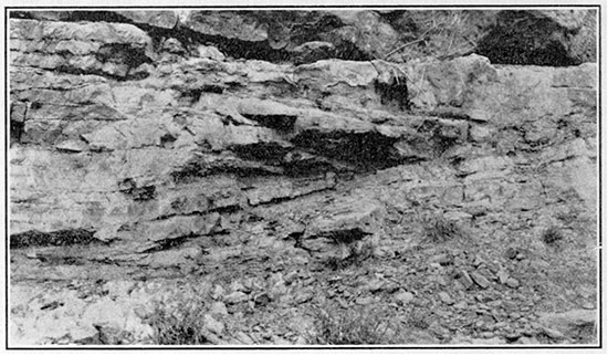
Figure 5--Slabs of chalky limestone of the Jetmore member of the Greenhorn limestone, shown as they typically cover the surface in areas of rather poor exposures. Sec. 24, T. 12 S., R. 15 W., Russell County.
Unnamed member--Below the Jetmore chalk lies an unnamed member consisting of about 35 feet of chalky shale that contains a few thin beds of chalk and clay. A rough quantitative analysis indicates that a sample of this marl included 65 to 70 per cent of silty material which contairied a few small flakes of muscovite. Perhaps the most prominent and most easily recognizable part of the member is a five-inch massive bed of hard medium-gray fine-grained chalk, which lies 14 or 15 feet above the base of the member and contains well-preserved Inoceramus shells, and flat vertical marks resembling blades of grass. Below this bed lies 1 or 2 feet of yellow or light bluish gray clay and some gray and green chalky shale, which overlie a softer, lighter colored, less fossiliferous bed of chalk of about the same thickness. Above the fossiliferous stratum lies a 2-foot or 3-foot bed of chalky shale, which is succeeded above by thin, slightly sandy, beds of chalk containing small pyritic nodules, and a few beds of yellow clay. This member thickens from 28 feet in the northern part of Russell County to about 40 feet in its southern part.
Lincoln limestone member--The lowermost subdivision of the Greenhorn limestone is here called the Lincoln limestone member. It consists of beds of chalk and chalky shale, with thin beds of hard dark gray crystalline slightly sandy fossiliferous limestone at its base and top and in some places near the middle. The limestones emit a strong odor of petroleum on fresh fracture. A few thin beds of yellow clay occur in the lower half of the member. The beds of crystalline limestone are commonly only 2 to 6 inches thick and are massive within this thickness. Under the microscope the rock is seen to be composed largely. of fibers derived from the prismatic layer of Inoceramus shells, with lesser amounts of spherical foraminifera, and a few brown, probably phosphatic granules, the whole imbedded in a matrix of finely crystalline calcite. Although dark gray on fresh surfaces these beds are greenish or brownish gray where somewhat weathered. The Lincoln member ranges in thickness from 20 feet in the western part of the county to about 25 feet in its eastern part.
Distinctive colors of the members--The marly beds of the Greenhorn limestone are dark gray where fresh, but become light, more or less yellowish gray on weathering. The members apparently contain different quantities of iron, for on weathering each develops a distinctive shade of yellow. The Jetmore chalk is the lightest colored member of the formation, its beds becoming a very pale, faintly creamy gray or near-white. The Lincoln member appears to be the most ferruginous, for where weathered it is a rather bright tan. The members above the Jetmore and the Lincoln assume intermediate colors, the one at the top of the formation being lightest, but both are a rich cream color.
Fossils--[Identifications by J. B. Reeside, Jr.]--The Greenhorn limestone contains an abundance of shells of Inoceramus labiatus Schlotheim--flat, elongated, tongue-shaped bivalve shells, commonly about 6 inches long, that are ornamented by concentric rounded ribs which themselves bear finer ribs. This fossil is most abundant in the lower part of the upper member and in the top layer of the Jetmore chalk, and although it occurs throughout the formation, it was not found beyond its limits. Other large fossils are not common in this formation, but a few other interesting species occur sparingly: Baculites gracilis Shumard, Metoicoceras whitei Hyatt, Helicoceras pariense (White), a second species like Helicoceras corrugatum Stanton, and a new species of the ammonite genus Puzosia. There are also scattered oysters much like Ostrea congesta Conrad, worm-eaten pieces of wood, [Apparently coniferous, according to F. H. Knowlton.] small fragments of teeth, scales and bones, and possible plant stems in the lower part. The surfaces of many of the chalk beds show nearly microscopic Globigerina, and these minute fossils make up probably one-fourth of the volume of the samples of chalky shale examined.
Topographic expression--The Greenhorn limestone is second only to the Fort Hays member of the Niobrara formation in topographic prominence, the thick series of relatively hard chalk beds nearly everywhere forming a steep benched slope or actual bluff. The Jetmore member makes the most conspicuous and persistent scarp, its topmost bed capping a steep slope, 10 to 20 feet high, at all but the very poorest exposures. The "fence-post limestone," at the top of the upper member, also makes a persistent bench, but as the underlying 20 feet is chiefly soft chalky shale, the slope capped by this bed is gentle, no conspicuous bluff being formed. The thin-bedded crystalline limestone at the top of the Lincoln member commonly forms a minor bench on the faces of the steep slopes of the Greenhorn limestone in the larger valley, and at some places where the slopes are gentler it makes a scarp distinct from that formed by the upper members, and traceable for a mile or more. At many places the similar strata at the base of the Lincoln and other chalk beds here and there throughout the formation form minor benches.
Soil and vegetation--Owing perhaps chiefly to the steepness of the slopes, the soil on the outcrops of the Greenhorn limestone is commonly thin. On the gentler south slopes of the divides, however, the soil may be sufficiently thick to mask all but the most prominent hard beds. Throughout most of the county the Jetmore bluff is either quite barren or is covered with a nearly white, thin, chalky loam, but the other members permit the accumulation of a thicker soil. Tall, coarse, native grasses are the commonest growths on the formation, but on a few of its more sheltered cliffs the Jetmore member supports clumps of small conifers.
Resemblance to other Cretaceous strata--The Greenhorn limestone resembles in its chalkiness the Smoky Hill and Fort Hays members of the Niobrara formation and the Fairport member of the Carlile shale. Its beds of chalk are thicker and more numerous and its weathered exposures are less stained with yellow than those in the Fairport member. It differs from the Fort Hays and Smoky Hill members chiefly in containing no thick, massive beds of chalk and in its inclusion, near the base, of thin beds of crystalline limestone. It further differs from the Fort Hays member in containing much interlaminated marl.
The contact of the Greenhorn limestone with the overlying Carlile shale is rather arbitrarily drawn at the top of the "fence-post limestone." No real lithologic distinction can be made between the lower 25 feet of the Fairport chalky shale member and the uppermost member of the Greenhorn limestone. In fact, the unit containing flat chalk concretions extends from about 22 below to 12 feet above this boundary. The paleontologic change, however, is fairly distinct. Inoceramus labiatus occurs only below the boundary and Inoceramus fragilis and Prionotropis woolgari only above it, and no zone of admixture of faunas was noted. Fortunately, this paleontologic change occurs at the top of an easily recognizable stratum, the "fence-post limestone." Distinctive sequences of chalk, chalky concretions, yellow clay, and chalky shale make the horizon easily determinable where the overlying rocks are exposed; and the characteristics of the individual chalk beds in the two members below the contact aid in determining the position of the boundary where the underlying beds are exposed. In addition, the widespread quarrying of the "fence-post limestone" is in itself a valuable aid in the recognition of that bed, but it must be employed with care, for at some places the chalk bed 5 1/2 feet above the "fence-post limestone," and at a few places other chalk beds above and below, have been similarly quarried. The gentle slope on the Fairport member is commonly farmed down to the chalk beds in the lower 25 feet of the member. From that point to the base of the Fairport member short grasses generally grow, but at the "fence-post limestone" there is a sharp change to taller, coarser grasses. The nearly white persistent bluffs on the Jetmore member are easily distinguished from the discontinuous exposures of cream and reddish tan shales on the gentler slopes of the upper member of the Greenhorn limestone and the lower part of the Fairport member. The contact is one that is not at all likely to be noted in well logs.
Value for detailed mapping--The thin but hard, persistent and widely distributed beds of chalk in the Greenhorn limestone make that formation almost an ideal one for detailed structural mapping, and the work done by commercial geologists in and near Russell County has been virtually restricted to two layers of chalk in the upper 20 feet of the formation--the "fence-post" and the "Inoceramus" beds. Throughout much of the area lower beds also may be profitably employed, the prominent upper and basal layers of the Lincoln member being good key beds for detailed mapping. For reconnaissance work the top of the conspicuous Jetmore member is the most satisfactory horizon in the Cretaceous section of western Kansas.
Names of members--Logan divided his lower limestone group (the Greenhorn and Graneros formations of this report) into five members. [Logan, W. N.; The Upper Cretaceous: Kansas Univ. Geol. Survey, vol. 2, pp, 216-217; 1897.] Four of these--the Lincoln, "flagstone," "Inoceramus" and "fence-post"--constitute the present Greenhorn limestone. Between the Lincoln member and the "fence-post bed" of the upper member, Logan's subdivisions are not recognizable in Russell County, though his "Inoceramus horizon" probably comprises the upper part of the Jetmore and the lower part of the upper member as delimited in this report.
Cragin proposed the name "Downs limestone" for the "fence-post bed." [Cragin, F. W.; On the stratigraphy of the Platte series or Upper Cretaceous of the Plains: Colo. Coll. Studies, vol, 6, p. 50; 1896.] Although this bed is unusually persistent for one so thin, it does not merit classification as a separate member, and its local name, "fence-post limestone," is widely known and quite satisfactory.
The name Jetmore is proposed for the 20-foot member that lies from 20 to 40 feet below the top of the Greenhorn limestone. It is taken from prominent exposures south and east of Jetmore, along the south side of Buckner creek, in Hodgeman county, Kansas. Although its base is indefinite in many places, the progressively varying alternation of chalk and chalky shale stamps this member as a definite unit of sedimentation. The usage among oil geologists of the term "Inoceramus bed" for the top stratum of this member may lead to some confusion, for Logan's "Inoceramus horizon" probably included chalk layers above and below this bed, but its prominence and persistence make the upper bed of the member so valuable for structural mapping that a name to emphasize its value is well deserved.
Lincoln "marble" was a local name applied to crystalline limestone quarried in Lincoln County, and was apparently first used in the literature as the name for a geologic unit by Cragin in 1896. [Cragin, F. W.; idem.] As a name for the quarried stone, marble is justified by usage, but a more precise lithologic term for the rock would be crystalline limestone.
Graneros Shale
The beds of clay shale that lie below the Greenhorn limestone and above the Dakota sandstone constitute the Graneros shale. This formation, which is about 40 feet thick, crops out as a continuous narrow band at the base of the Greenhorn bluffs along the larger streams in Russell County. It contains thin, hard, sandy layers, which are few and calcareous near the top and more abundant and highly ferruginous in the lower half. Irregular variations in the thickness of the formation of as much as 20 feet are due to the lenticular form of the beds of sandstone at the base of the Graneros shale and top of the underlying Dakota sandstone.
Lithology--The soft, noncalcareous, gritless shale of this formation is very fissile, and where naturally exposed is a dark bluish gray. In places the weathered slopes are strewn with crystals of selenite and stained rusty brown, and the minor joints are covered with a sulphur-yellow powder. The iron sulphate melanterite is abundant on the weathered outcrops, and its bitter taste is fairly characteristic of the formation.
Some one-inch beds of sandy limestone occur in the upper part of the Graneros shale. In the southwestern part of the county a thin-bedded, somewhat iron-stained bed of sandstone a few inches thick, which lies about 10 feet below the top of the formation, is strongly ripple-marked on its upper surface. These ripples are of the symmetric or oscillation type, and commonly have an amplitude of about a quarter of an inch and are 2 inches from crest to crest. They trend about S. 30° W. In some localities a white to yellow clay bed, slightly more than an inch thick, occurs about 2 feet below the top of the formation. At many places the lower half of the formation contains numerous beds of hard, ferruginous, gypseous sandstone, from 1 to 6 inches thick. These beds are discontinuous laterally, few of them being traceable more than 200 or 300 feet.
Local zones of calcareous concretions were found at two horizons. In the southeast part of the county the upper concretions are about 2 1/2 feet below the top of the formation; they are fossiliferous and distort the bedding of the overlying shale for as much as a foot with slender nodular protuberances that extend into the upper beds. The lower concretions, which occur about 20 or 25 feet below the top, are also fossiliferous and are very argillaceous and sandy. In places they contain cone-in-cone layers less than. half an inch thick.
Fossils [Identifications by J. B. Reeside, Jr.]--Several of the harder beds in the upper part and a few in the lower part of the Graneros shale are fossiliferous. The small oysterlike shell, Exogyra columbella Meek, with curled beak and rather fine, low-rounded ribs, occurs in the lower half of the formation and is usually accompanied by the small pelecypods, Callista tenuis Hall and Meek and Corbula nematophora Meek. At a few places in the lower part of the formation the high-spired gastropod, Turritella whitei Stanton, and fragments of fish teeth, bone and scales were found at several horizons throughout the formation. In the upper part a medium-sized undescribed oyster occurs abundantly at some places accompanied by a large undescribed species of Prionotropis, also known in the upper or Belle Fourche shale member of the Graneros shale of the Black Hills region.
Exposures--The Graneros shale is soft and at many of its outcrops makes a gentle slope. In parts of the larger valleys the hard overlying Lincoln member of the Greenhorn limestone and the sandstone beds in the underlying Dakota formation make a steep bluff in which the Graneros shale is well exposed, but at such places talus and slides from the Greenhorn exposures obscure parts of it.
Distinguishing features--This formation resembles only the Blue Hill member of the Carlile shale and some beds in the Dakota sandstone. The dark fissile shales, with their persistent melanterite taste, are nowhere chalky, though in places they include thin, hard, calcareous layers. The occurrence of harder, sandy strata that are commonly ferruginous, the absence of abundant calcareous concretions, the thinness of the formation as a whole, and the underlying series of beds of sandstone and variegated shale serve to distinguish it from the upper member of the Carlile shale. The contact of the Graneros shale with the overlying Greenhorn limestone is not difficult to determine, even in places where a foot or more of transitional strata occur, The Greenhorn limestone contains no beds of argillaceous shale, and the beds of crystalline limestone at the base of the Lincoln member are sufficiently distinctive to permit ready recognition.
Unsuitability for mapping--The Graneros shale is not well adapted to detailed structural mapping, for it is well exposed at but few places. The thin, hard beds in its upper part are persistent, but the more ferruginous ones in the lower part are extremely lenticular and untrustworthy. Horizontal proximity' to the persistent and easily recognizable base of the Lincoln member of the Greenhorn limestone makes the use of Graneros strata unnecessary at most places. However, the Graneros shale contains the stratigraphically lowest beds that may be relied upon for tracing, and in parts of the broader, deeper valleys of Russell County it contains the only key beds available.
Name and correlation. The Graneros shale was so named by Gilbert from exposures at Graneros and on Graneros creek, in Pueblo County, Colorado. [Gilbert, G. K.; The underground waters of the Arkansas Valley in eastern Colorado: U. S. Geol. Survey Seventeenth Ann. Rept., pt. 2, p. 564; 1896.] Although the beds in Kansas had previously been correlated with the Graneros of Colorado by Logan, [Logan, W. N.; The Upper Cretaceous of Kansas: Kansas Univ. Geol. Survey, vol. 2, pp. 232-234; 1897. Also, A discussion and correlation of certain subdivisions of the Colorado formation: Jour. Geol., vol. 7, pp, 83-91; 1899.] Darton, [Darton, N. H.; Comparison of the stratigraphy of the Black Hills, Bighorn Mountains, and Rocky Mountain Front Range: Geol. Soc. America Bull" vol. 15, p, 445; 1904.] in 1904, was the first to apply the name Graneros to the rocks in Kansas.
The fossils found in the Graneros shale in Russell County are typical of the Graneros elsewhere, but they do not indicate clearly the particular part of the much thicker Graneros of the Rocky Mountain region to which the Kansas strata are most nearly equivalent. [J. B. Reeside, Jr.; personal communication.] The abundant small pelecypods are similar to forms found in western Wyoming in the lower part of the Thermopolis shale (equivalent to basal Graneros), but the cephalopod found near the top of the formation in Russell County closely resembles a form found near the top of the uppermost member of the Graneros in northeastern Wyoming.
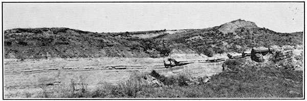
Figure 6--Contact of the Graneros shale and Dakota sandstone, Lensing strata of evenly bedded sandstone at top of Dakota formation make contact about 8 feet lower stratigraphically in right foreground than in left. View southeastward in NE sec. 33, T. 12 S., R. 14 W., Russell County.
Dakota Sandstone
The thick series of beds of variegated sandy shale and lentils of sandstone that make up the bed rock in the floors and sides of the larger valleys in Russell County is the Dakota sandstone. About 160 feet of the upper part of this formation is exposed in Russell County. More than half the beds consist of shale or sandy shale, but the most prominent constituent of the formation at its outcrops is the harder sandstone. The shale is variegated and gray, sandy and argillaceous; the sand in the sandstones is well sorted. Lignite and calcareous concretions occur at some horizons. The horizontal variation in the composition of the formation is great, sandstone bodies 50 to 100 feet thick in some places giving way entirely to variegated shale within distances of less than half a mile. In general the upper 10 feet or so is regularly bedded sandstone and the lower beds are shale, but thick lenses of cross bedded sandstone occur in places throughout the formation.
The formation was named by Meek and Hayden, in 1861, from exposures near the town of Dakota, in northeastern Nebraska. [Meek, F. B., and Hayden, F. V.; Descriptions of new lower Silurian (Primordial), Jurassic, Cretaceous and Tertiary fossils collected' in Nebraska Territory [etc.]: Phila. Acad. Nat. Sci. Proc. 1861, vol. 13, PP. 419-422; 1862.] In Russell County, Kansas, the Rocktown channel sandstone member occurs irregularly in the upper 125 feet of the formation.
Evenly Bedded Strata
Upper sandstone unit--At most of the outcrops in Russell County a series of beds of fine- to very fine-grained, evenly bedded or massive sandstone, from 5 to 20 feet thick, lies at the top of the formation, but in places this unit is absent. Wherever found, these beds of sandstone contain more highly ferruginous layers and fairly abundant plant remains consisting of pieces of carbonized wood, or flat, vertical, grasslike marks. Despite the regularity of bedding, the individual layers are very discontinuous, the top of the formation in some places varying 10 feet in stratigraphic position within a few hundred feet along the outcrop (Fig. 6). A few miles northwest of Lucas a concretionary bed of tan sandy limestone about an inch thick occurs at or near the top of the formation.
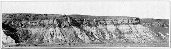
Figure 7--Evenly bedded sandstone at the top of the Dakota formation, underlain by variegated shale that is intricately dissected into "bad-land" slopes. View northeastward, sec. 34, T. 12 S., R. 14 W., Russell County.
Lignitic beds--In the southeastern half of Russell County beds of lignite from 1 to 2 feet thick are found near the base of the upper sandstone unit, where it is present, or at the top of the formation where the sandy beds are absent. Although two coal beds were not seen in any one section, the different outcrops of coal probably do not lie at the same horizon, although all may fall within one general zone. The lignite in these beds is apparently composed entirely of broken fragments of carbonized wood with which some silty material is intermixed. Abandoned caved prospect tunnels and mounds of shale dumps at many places in the area show that rather extensive but futile efforts have been made to discover commercial deposits of coal. It is reported that considerable coal was actually mined many years ago on Coal creek near the southwestern corner of the county.
Clay shale beds--Under the evenly bedded sandstone and lignite beds in Russell County lies a series of light gray, fissile, gritless clay shale, containing some hard, ferruginous and sandy beds a few inches thick. This unit is generally 15 to 40 feet thick, but in many places it is absent. Some of the thin layers of sandstone contain fragments of carbonized wood. Ferrous sulphate occurs on weathered surfaces of these beds, giving them a peculiar bitter taste.
Variegated mudstone unit--The gray clay grades downward and in some places laterally into hard, massive light greenish gray shale or mudstone mottled with subordinate amounts of bright to dull cherry, maroon, lavendar, brown, and tan. The beds of variegated mudstone alternate with layers of dark gray to black carbonaceous clay. This variegated mudstone is chiefly sandy, but some layers in nearly every section examined are grit-free clay. Small, limy, nodular lenses cut more or less obliquely through the exposures, and thin discontinuous beds of white to heavily rust-stained sandstone occur throughout the unit. At one place, in sec. 4, T. 13 S., R. 11 W., Russell County, a very hard, pyritiferous, sandy, calcareous concretion about 4 feet in diameter was found about 125 feet below the top of the Dakota sandstone. The bedding of the surrounding sandstone is continuous into the concretion. Ferrous sulphate and layers of carbonized wood occur at a few horizons in this unit. The variegated shale extends at least to the lowest strata of the Dakota sandstone exposed in Russell County; that is, to a depth of 160 feet below the top of the formation.
Rocktown Channel Sandstone Member
Occurring locally at almost any horizon from the top to 125 feet below the top of the Dakota sandstone there is a series of very discontinuous, highly cross-bedded sandstone strata that is here named the Rocktown channel sandstone member of the Dakota sandstone.
Lithology--These beds are generally hard where exposed to weathering, but unconsolidated back an inch or so from the outcrop. Although the rock is rather uniformly a light buffy gray where fresh, the weathered exposures of it show all shades of brown, yellow, red, and gray. A few thin lenses of fissile, bluishgray shale are interbedded with the sandstone. The beds of sandstone vary greatly in thickness within short distances. In sec. 3, T. 13 S., R. 14 W.; secs. 5 and 9, T. 13 S., R. 12 W., and elsewhere in Russell County, cross-bedded sandstone crops out in thicknesses of more than 25 feet on one side of a narrow valley, but only gray and variegated shale is seen at the same stratigraphic position on the opposite side. Clean exposures show that changes of thickness so abrupt take place either by interfingering of the sandstone and shale, as in sec. 11, T. 13 S., R. 12 W., where the cross-bedded sandstone strata thicken 15 or 20 feet at their base in about 200 feet along the outcrop (Fig. 8), or by local unconformity, as in sec. 22, T. 12 S., R. 13 W., where the base of the sandstone cuts more than 25 feet into the underlying shale (Fig. 9).
Figure 8--Interfingering of Rocktown channel sandstone member and variegated shale in the Dakota sandstone, in sec, 11, T. 13 S., R. 12 W. View westward.
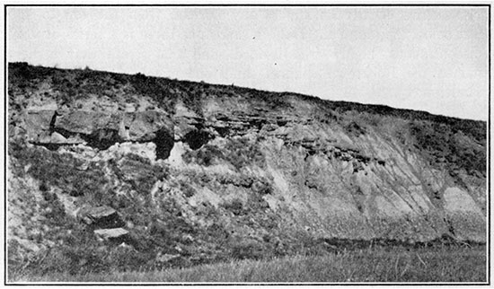
Figure 9--Local unconformity of the Rocktown channel sandstone member on shale beds in the Dakota sandstone. Sec. 22, T. 12 S., R. 13 W., Russell County. View northward.
The sandstone is fine to coarse grained, its grains ranging from less than 0.06 to more than 10 millimeters in diameter, but most of them in nearly all the samples examined ranged from 0.1 to 0.5 millimeters, with 0.25 the commonest diameter. The grains of sand are finer where the sandstone grades laterally into shale. Despite the great difference of size of grains in different pieces of the rock, individual samples were nearly all very well sorted, the largest grains being uniformly only twice the diameter of the smallest abundant grains. The sandstone consists mainly of grains of colorless quartz, but it includes grains of pink transparent quartz, black opaque fragments, and pebbles of clay, the largest 10 millimeters in diameter. Clay pebbles are generally considered proof that the beds containing them were exposed to the air during at least part of the time of their deposition. The finer-grained samples contain also flakes of muscovite, and a red, probably secondary powder fills the interstices of some of the weathered samples. The grains range from highly angular to well rounded, but in almost every hand specimen collected most of them are subangular. Some at least of the extreme angularity found is due to recrystallization. The larger fragments in general are better rounded and show more or less of the "ground-glass" or "frosted" surface generally thought to be produced by wind action.
The cross-bedded laminae in this member dip from 5° or less to nearly 300 in every direction, but dips of about 22° southwest, west or northwest are most common. Within one stratum that shows oblique bedding the dip is slightly steeper at the top and flatter at the base-that is, the lower cross-bedded laminee become more nearly tangent to the base of the stratum-and in the thicker strata this condition is at some places very striking. The diagonal lamina are in beds from 1 inch to 8 feet thick, though 6 inches to 3 feet is the more usual range; or, to put it in another way, the forset beds are commonly from 1 1/2 to 8 feet long. The beds that show oblique lamination are generally separated by evenly bedded, somewhat thinner strata, but at many places two cross-bedded layers are in immediate contact and the top of the lower layer is abruptly truncated by the upper. In general, though not in detail, the cross-bedding has the same direction throughout any particular vertical series. The bounding planes between the cross-bedded and non-cross-bedded strata are nearly but not strictly parallel; that is, each individual stratum, although of nearly uniform thickness throughout, varies somewhat. In some places these bounding planes dip a few degrees either at right angles to or nearly in the opposite direction from that of the cross-bedded laminre. Nearly all these features (alternating and essentially parallel layers of rather thin, cross-bedded and thinner evenly bedded strata with the successive cross-bedded layers dipping in the same direction) are peculiar to the torrential type of cross-bedding that is characteristic of stream-channel deposits. [Grabau, A. W.; Principles of stratigraphy, pp. 590, 702-703, 704-706; 1913.] However, it is conceivable that this type of cross-bedding might be formed in the sediments deposited in delta distributaries and marine straits.
Distribution of the sandstone lenses--The lenticularity, composition and bedding of the member afford much evidence that it was deposited by streams, and with this interpretation in mind an attempt was made to determine the course of the possible streams from the now disconnected lenses of sandstone. These sandstone lentils appear to lie in long, more or less sinuous belts a few miles or less wide, the most conspicuous of which are those in the valley of Saline river, in the eastern part of Russell County. The approximate parallelism of the direction of cross-bedding with the elongation of these lenses observed at a number of places furnished a clue for the interpolation of the supposed channels where the sandstone lenses are buried by younger rocks or removed by later erosion. By this process it was found that all but a very few of the sandstone lenses near Saline river fall into one meandering zone that indicates a general westerly direction of flow of the depositing stream. The remaining isolated lenses suggested tributary streams, and in some places a braided condition of the channel, and even channels that diverged westward from the main zone. However, in determining this preliminary zone the stratigraphic position of the different sandstone lenses had not been considered. By taking into account the relative ages of the lenses (the interval to the top of the Dakota sandstone), the direction of cross-bedding at different stratigraphic positions, and the usual changes in the course of a meandering stream, a second series of zones was drawn (Plate III). For instance, in sec. 22, T. 12 S., R. 13 W., and in sections to the northwest, the sandstone is from 20 to 75 feet below the top of the Dakota sandstone and cross-bedded northwestward, but from sec. 31, T. 12 S., R. 13 W., to sec. 6, T. 13 S., R. 14 W., it is at or near the top of the formation and the cross-bedding dips west-southwestward. This was taken to mean that the stream first flowed northwestward from sec. 22, T. 12 S., R. 13 W., but that after the valley had been more nearly filled by alluviation it flowed westward in a new channel. Also, in sec. 31, T. 12 S., R. 13 W., where the stream may have flowed but a short time, the sandstone is, only 15 feet thick, but in sec. 4, T. 13 S., R. 11 W., where the stream is supposed to have remained much longer, the sandstone accumulated to a thickness of 100 feet. This conception of various stages of meanders seems to explain all the sandstone lenses observed in the valley of Saline river as the deposits from one continuous, meandering, shifting stream with one or two smaller tributaries.
Figure 10--Sandstone "hoodoos" in Rocktown, in sec. 4, T, 13 S., R. 11 W., Russell County. Rocktown channel sandstone member of Dakota sandstone weathered into vividly stained houselike blocks.
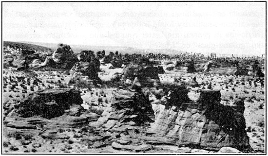
Figure 11--A sandstone "hoodoo" in Rocktown. A weathered projecting mass of Rocktown channel sandstone, in sec. 4, T. 13 S., R. 11 W., showing oblique laminee dipping westward.
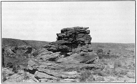
Plate III shows the outcrops of cross-bedded sandstone and the observed directions of most prominent cross-bedding in the member. It also shows approximately the location of the more or less obscured and eroded connections between the isolated lentils of sandstone.
Cross-bedded sandstone was noted in other outcrops of the Dakota sandstone in Russell County, but the lenses are thinner and the outcrops more isolated. The fortunately close coincidence in the position of the old channel with the present valley of Saline river makes possible a reconstruction of the old stream course, and whether or not there are other parallel or tributary channels is not definitely known.
Name--The Rocktown channel sandstone member is named from the excellent exposures of the member at and near the large group of "hoodoos" or houselike blocks of sandstone in the northwest quarter of sec. 4, T. 13 S., R. 11 W., locally known as Rocktown.
Origin
The Rocktown member was evidently laid down by a rather large stream, which in Cretaceous time flowed westward through Russell County. The ground-glass surface found on some of the sand grains may have been developed far to the east and the grains transported to Russell County by the stream; or wind drifting of sand on bars and shores much nearer may have caused it.
The environment assumed in explanation of the origin of this member suggests interpretations of the conditions of deposition of some of the associated units in the Dakota sandstone. The variegated and carbonaceous mudstones in which the Rocktown member is interbedded might be interpreted as silts and fine sands deposited in the back waters of wide flood plains, the various colors possibly being due to different degrees of oxidation. The gray clay shale might by the same reasoning be explained as muds deposited in deeper, more permanent bogs where they were at no time exposed to the effects of weathering. The occasional lenticular ferruginous layers might be the result of the precipitation of iron carbonate in local bogs. The evenly bedded sandstone unit at the top of the Dakota may have been deposited as beach sands, the immediately ensuing marine Graneros shale and the general aggradation of the stream valley suggesting an encroachment of the sea. The fragmental silty lignite beds may have been transported from elsewhere and formed from buried accumulations similar to log jams, but their position just below the possibly marine upper sandstone unit suggests that they may be the result of tidal marsh deposition.
Fossils in the Dakota Sandstone
Plant remains are essentially the only fossils found in the Dakota sandstone in and near Russell County. Well-preserved leaves of Lomatia? saportanea (Lesquereux) Lesquereux, Sassafras mudgii Lesquereux, Celtis? ovata Lesquereux and Populus sp., were obtained in a highly ferruginous layer at the very top of the Rocktown member (there about 20 feet below the top of the Dakota sandstone) in the southwest quarter of sec. 22, T. 12 S., R. 13 W. [F. H. Knowlton, who identified these fossil plants, reports that all are well-known Dakota species.] Fragments of leaves occur in heavily iron-stained beds in the shale and at the top of the cross-bedded sandstone at several places in and near Russell County, from 20 to 55 feet below the top of the formation. Indistinct plant stems and fragments of carbonized wood were noted at many places throughout the formation. Cylindrical marks that are probably worm tubes were found in the uppermost regularly bedded sandstone of the Dakota sandstone in sec. 6, T. 15 S., R. 10 W., Ellsworth County. No vertebrate or invertebrate remains were noted, but northeast of Russell County, in Lincoln and Mitchell counties, marine invertebrates of Upper Cretaceous age have been found in the beds near the top of the formation. [Stanton, T. W.; Some problems, connected with the Dakota sandstone: Bull. Geol. Soc. America, vol. 33, pp, 259-261; 1922.] Southeast of Russell County, in Saline, Ellsworth and McPherson counties, marine invertebrates have been found in Comanche strata in the lower 100 feet of the sandstones and shales immediately below the Dakota sandstone. [Twenhofel, W. H.; The Comanchean of central Kansas: Kansas Acad. Sci. Trans., vol. 28, pp. 213-223; 1917. Twenhofel, W. H.; The Comanchean and Dakota strata of Kansas: Am. Jour. Sci., 4th ser. vol. 49, pp. 281-297; 1920.]
Varying Prominence
The Dakota sandstone; because of the extreme lenticularity of its harder beds and the wide range in the color of its beds of shale and sandstone, is one of the most striking formations that crop out in Russell County. Except for the lentils, however, it is rather soft, and makes broad, flat valleys. The hard variegated shale is at many places prominently exposed in intricately dissected bluffs--a typical "bad-lands" surface on a small scale (Fig. 7)--but the dark clay shale near the top of the formation is soft and is well exposed at but few places. The uppermost evenly bedded, fairly persistent sandstone makes a series of flat benches below the Graneros outcrop, the number of scarps depending upon the number of hard ferruginous or sandstone layers in the section. The Rocktown sandstone member forms a peculiar topographic feature where slightly harder parts of its outcrops weather to groups of "hoodoos"--more or less isolated; irregularly shaped cones or blocks from 5 to 15 feet high (Figs. 10 and 11). The sandstone in these weathered blocks shows vivid colors--bright reds, yellows and rich browns alternating with buff, white and gray.
The residual soils on the outcrop of the Dakota sandstone are usually very sandy, but in most of Russell County the formation is obscured by a later covering of alluvium. In many places yucca grows rather abundantly where this formation is at the surface. Seeps of water from the base of sandstone ledges are fairly common in the deeper valleys.
Similarity to Other Strata
The Dakota sandstone is the only Cretaceous formation in Russell County that contains variegated shale and much sandstone. Cenozoic deposits are also sandy, but are almost invariably coarser and contain many fragments of feldspar and particles of rock not found in the Dakota sandstone. The soft beds of fissile clay shale generally found near the top of the Dakota resemble those of the Blue Hill member of the Carlile shale and' the Graneros shale. The abundant calcareous concretions in shale beds of the Blue Hill member and the thin sandy layers common in the shale in the Dakota sandstone serve readily to distinguish the two. The Graneros shale, however, cannot be easily differentiated from the Dakota sandstone everywhere, for sandstone and clay shale beds are found in both. At most places the base of the fissile gray shale coincides with the top of a hard, regularly bedded sandstone, from 5 to 20 feet thick, which lies about 40 feet below the top of the Graneros shale, but interfingering of the layers of shale and sandstone at many localities causes this contact to range through a stratigraphic interval of about 20 feet. Logs of wells in Russell County indicate that the evenly bedded sandstone is not present in some places at the top of the Dakota formation, and the underlying clay shale is quite indistinguishable from the Graneros shale. In these wells the top of the variegated shale or sandy shale, which is recorded in the logs as red shale or red rock, is doubtless at a variable distance below the top of the Dakota sandstone.
Uselessness of the Dakota Sandstone for Mapping of Structure
The Dakota sandstone is practically useless for detailed mapping. No bed within the formation is persistent throughout the county, and possibly no one layer can be traced more than a few thousand feet horizontally, and many lenses extend much less than a thousand feet. Discontinuity alone is not the only characteristic that renders most of the beds unsuitable for use in detailed mapping of structure, for many strata cut obliquely through the adjacent beds of shale, and some of the intervals between different hard layers vary greatly within short distances. No beds in the Rocktown member are suitable for structural mapping, the lenticularity and (where the sand was deposited on a sloping surface) the primary dips of the strata and the continuous shifting of the course of the stream leaving no layers that can be depended on. The carbonaceous and lignitic beds are discontinuous, and the fragmental nature of the constituent woody material suggests that they were not deposited in a widespread swamp of growing vegetation, as most coal beds are supposed to have been formed elsewhere, but may have been formed from flood-carried debris deposited in local backwaters. The 'flatness of the flood plain suggested by the aggradation that evidently occurred and by the meandering of the channel would seem to make some of the layers of silt or mud deposited on the flood plain fairly reliable key beds, but these silty strata are soft and sufficiently well exposed for recognition and tracing in but a few places in Russell County. The evenly bedded sandstone strata at the top of the formation most nearly fill the requirements for this type of mapping, but the individual layers of even this unit are highly lenticular (Fig. 7). It seems that detailed structural mapping is impossible in the area of the Dakota outcrop in Russell County. It is also impracticable to drill shallow holes to some easily recognizable horizon, for the well logs show that the series of beds of shale and sandstone that form the Dakota (and possibly the Comanche) is from 300 to 400 feet thick in Russell County and is underlain unconformably by a thick series of equally variable beds of red shale and sandstone,
Rocks Concealed
Beneath the Cretaceous rocks in Russell County lie strata that belong to older geological divisions, which are more or less closely equivalent to those that appear at the surface farther east and south. The only direct information concerning these concealed rocks is that given by records of deep borings. The field work in Russell County included the collection of records of drilled wells and numerous samples of drill cuttings from operators and drillers, who generously cooperated in this work. A detailed study of these data and a tentative correlation (Plate VI) of the rock formations with those in the oil fields of central and eastern Kansas has been made by Mr. Bramlette, whose report forms a part of this bulletin.
Prev Page--Rocks Exposed, Mesozoic || Next Page--Structure
Kansas Geological Survey, Geology
Placed on web March 17, 2014; originally published 1925.
Comments to webadmin@kgs.ku.edu
The URL for this page is http://www.kgs.ku.edu/Publications/Bulletins/10/03_rocks3.html