![]()
Prev Page--Introduction || Next Page--Rocks Exposed, Mesozoic
Rocks Exposed
The surface rocks in Russell County are all included in the Cretaceous and Cenozoic divisions of geologic time. They are younger than the stratified rocks of central and eastern Kansas, the equivalents of which in Russell County are buried more or less deeply. The following table shows the rock formations of this area in order from youngest (at the top) to oldest (at the bottom), including the main divisions of the rocks concealed below the surface as well as those which are exposed. Rocks older than the Dakota sandstone are not exposed, but were identified by M. N. Bramlette from a study of well cuttings and drillers' logs.
| Table of rock formations in Russell County, Kansas | ||||||
|---|---|---|---|---|---|---|
| Era | System and series | Group, formation, and member a | Lithologic character | Thickness, in feet |
||
| Cenozoic | Quaternary | Recent | Alluvium, soil and talus material. Lower terrace deposits and gravels along streams. | 0-50 | ||
| Pleistocene | McPherson (?) formation | Upper gravel deposits along main streams. | ||||
| Tertiary (?) | Ogallala (?) formation | High gravels on divides. | ||||
| Mesozoic | Cretaceous | Upper Cretaceous |
Niobrara formation |
Smoky Hill chalk member | Clayey chalk and chalky shale, with scattered ferruginous concretions. | 0-50 |
| Fort Hays limestone member | White or tan massive chalk beds. | 55 | ||||
| Carlile shale |
Blue Hill shale member | Gray fissile clay shale, containing concretions, with sandstone near the top. | 215 | |||
| Fairport chalky shale member | Chalky shale and thin beds of chalk. | 85 | ||||
| Greenhorn limestone |
Upper member | Chalky shale containing thin beds of chalk. | 20 | |||
| Jetmore chalk member | Alternating thin chalk beds and chalky shale. | 20 | ||||
| Unnamed member | Chalky shale with a few thin beds of chalk. | 28-40 | ||||
| Lincoln limestone member. | Chalk, chalky shale, and thin beds of hard crystalline limestone. | 20-25 | ||||
| Graneros shale. | Dark bluish clay shale. | 40 | ||||
| Dakota sandstone |
Rocktown channel sandstone member | Variegated and gray clay and sandy shale and evenly bedded sandstone. Exposed in Russell County, 160 feet. | 300-400 | |||
| Lenses of cross-bedded sandstone in upper 125 feet of formation. | ||||||
| Lower Cretaceous (?) | Bluish shale and brown sandstone containing leaves and marine invertebrates; exposed in western Saline county; may possibly extend under the Dakota of Russell County. | |||||
| Paleozoic | Carboniferous | Permian | Cimarron group | Predominantly red sandstone, and shale with anhydrite, and gypsum beds at some horizons. | 400-600 | |
| Sumner group |
Wellington formation | Gray shale, with anhydrite and massive rock salt. | 300-400 | |||
| Marion formation. | Gray shale, anhydrite, and dolomite; red beds with fossiliferous cherty limestone in lower part. | 400 | ||||
| Chase formation | ||||||
| Council Grove formation | Shale, limestone, and red beds. | 400 | ||||
| Pennsylvanian | Wabaunsee formation | Blue shale, and thin beds of limestone and sandstone | 450 | |||
| Shawnee formation (to base of Topeka limestone member) | ||||||
| Shawnee formation (from base of Topeka limestone) | Limestone and small amounts of shale and sand. Yields oil in Russell county. | 300 | ||||
| Douglas formation (to base of Oread limestone member). | ||||||
| Pennsylvanian formations below the Oread | Fossiliferous limestones and gray shales. | 100-400 | ||||
| Carboniferous (Pennsylvanian or earlier). | Shale, red rock, and thin limestones. | 150± | ||||
| Ordovician (and earlier?).* | Shale, red rock, and cherty, sandy dolomite, containing Ordovician fossils at top. | 500± | ||||
| a. A lithologic term, like sandstone or limestone, that is in current usage for a formation or member, has customarily been applied in local areas if this lithologic name emphasizes an important characteristic of the unit or if this lithologic type. is the conspicuous one in the exposures, even though a large part of the unit is some other rock. Although the lithologic terms in the names, Smoky Hill chalk, Fort Hays limestone, Greenhorn limestone, and Dakota sandstone, are not exactly descriptive of these units in Russell County, they are used, in accordance with this custom in this report. b. The United States Geological Survey classifies the units above the Cherokee shale as groups instead of formations, and divides the Marmaton into two major units--the Pleasanton and Henrietta groups. * Unweathered fragments of granite were found by C. S. Ross, of the United States Geological Survey, in drill cuttings from the Producers and Refiners Oil Corporation, Haise No. 1 well, NW SE sec. 24, T. 12 S., R. 15 W., Russell County, from depths of 3,628 to 3,632 feet, nearly 700 feet below the Oread limestone. Although the rock penetrated is probably granite, it may possibly be arkose, a sedimentary rock made of granite pebbles. |
||||||
Cenozoic
The outcropping Cretaceous rocks in Russell County are overlain discontinuously by deposits of sandstone, gravel, and silt of Cenozoic age. In date of formation these rocks range from Recent to probably late Tertiary. Careful study of these scattered deposits was not attempted in the field because their possible economic value is not related to the oil and gas resources. They may be classified in the order shown in the table.
Recent
Alluvium, Soil, and Talus Material
A veneer of rock material is now being formed throughout Russell County. This veneer includes the alluvium that is accumulating in the channels and lower valleys of nearly all the larger streams, especially in the parts of Smoky Hill and Saline valleys where the river meanders. On the flat uplands and the gentle south slopes of the broad divides a mantle of soil a few feet thick, largely residual, is also being formed. The lithology of the soil varies in detail from place to place, but generally corresponds with that of the underlying bedrock. Its composition is considered more fully in the descriptions of the exposed subdivisions of the Cretaceous strata. Heaps of more or less weathered talus material abound at the bases of bluffs formed by the Dakota, the Niobrara, and especially the Greenhorn formation.
Lower Terrace Deposits
Along Saline river and its larger tributaries, and less conspicuously along Smoky Hill river, a persistent terrace rises about 20 feet above the level of the streams. The deposits on this terrace are noted for their fertility, and form the soil of some of the best farms in the region. These deposits are conspicuously developed on the wide flat near the mouth of Paradise creek, in the western part of T. 12 S., R. 13 W.
The smaller tributaries throughout the county have recently cut into their stream beds and developed a terrace that may possibly be correlated with the 20-foot terrace of the Saline river valley.
Dune Sand (?)
Large deposits of dune sand lie in the valleys of some of the larger streams of western Kansas. No deposit of this type was found in Russell County, unless a few sod-covered sandy knolls on the north bank of Smoky Hill river are ancient dunes.
Pleistocene
Gravel Deposits of Saline and Smoky Hill Rivers
Subdivisions of the gravels--In the valleys of Saline and Smoky Hill rivers and their larger tributaries there are deposits of coarse gravel, which lie from 20 to 70 feet above the present streams. Volcanic ash was found near the top of such gravel beds north of Smoky Hill river. Along Saline river these beds can be subdivided into deposits at two levels: (1) the lower, and presumably younger, gravel ("Salt Creek gravel beds" of Logan), which occurs rather uniformly about 50 feet above the present stream grades; and (2) the higher beds, which lie from 40 to 70 feet above the present streams. [Logan, W. N.; The Upper Cretaceous: Kansas Univ. Geol. Survey, vol. 2, pp, 218-219; 1897.] Where the two occur in the same section the lower gravel is about 15 feet below the higher.
Lower gravel beds on Saline river--The lower gravel is found at many places in northwestern Russell County, especially near the mouth of Salt creek, 5 miles north of the town of Russell. The deposit forms a stratum that is well cemented with lime, persistent over small areas and averages about 2 feet in thickness. It is in many places steeply crossbedded from the west and is composed chiefly of quartz pebbles, but at some places it contains abundant fresh fragments of pink orthoclase and flat pieces of chalk, some of which inclose Inoceramus shells. The individual pebbles range in diameter from a thirty-second of an inch to an inch.
Upper gravel beds an Saline river--Beds of unconsolidated gravel, 10 feet or more thick, of essentially the same composition as the lower gravel beds, but containing a few lenticular beds of sandy clay about a foot thick, are found along Saline river. This gravel is quarried north of Russell, and used locally in making cement. Possibly because the beds are less consolidated, cross-bedding is not so conspicuous in them as it is in the lower gravel.
Gravel beds near Smoky Hill river--Along the north bank and. the tributaries of Smoky Hill river beds of gravel about 10 feet thick, very similar to the upper beds of gravel on Saline river, are in some places found at levels ranging from 20 to 60 feet above the streams. This gravel consists chiefly of quartzite pebbles, some of which are made shiny by "desert varnish," bits of silicated wood, granite, basaltic rock and chert, and beds composed almost solely of flat, unweathered fragments of chalk about an inch across, deposited so as to show an imbricated structure. These gravel beds contain grains of pink feldspar, and are poorly sorted, the most abundant grains ranging in diameter from about 0.5 to 3 millimeters. [See Seaton, R. A., and Taylor, I. I.; Tests of Kansas sands for use in mortar and concrete; Kansas State Agr. Coll. Eng. Experiment Sta. Bull. 3, pp. 10, 16, 38; 1916.] Some of the beds are slightly cemented with calcium carbonate. This gravel is quarried for local use as construction material. South of the town of Russell there are springs and large seeps. at the base of this gravel.
Volcanic ash--On the west side of a small valley near the southwest corner of sec. 19, T. 14 S., R. 13 W., a lenticular bed of volcanic ash more than 5 feet thick is exposed for over 350 feet horizontally in the upper part of the gravel beds near Smoky Hill river, just described. The ash is white to cream colored and is very thin bedded. It lies with sharp contact on a bed of chalk pebbles, but its, upper limit is obscured.
The grains of the ash are extremely small and very angular. Under the microscope they are seen to possess the vitroclastic and cellular texture and the isotropic optical properties characteristic of volcanic ash. The beds may be identified in the field by their inactivity with hydrochloric acid and the abundance of minute surfaces that reflect light (which distinguish them from loose lime), and by the extreme fineness and angularity of the grains, and their loose, unconsolidated texture (which distinguish them from sandstone).
No other deposit of volcanic ash was found in Russell County. In a well dug near the courthouse at Russell a bed of white, powdery substance 4 feet thick was encountered 8 feet below the surface and was reported to have "blown away when thrown out upon the ground." This may have been either volcanic ash or loose lime.
Fossils
On the west side of Fossil creek, north of Smoky Hill river, in the southeast corner of sec. 25, T. 14 S., R. 14 W., in Russell County, J. L. Phinney, a resident of Russell, while excavating in a bed of gravel near some springs there, found a large tooth and a few bones. Mr. Phinney gave these fossils into the keeping of the writers until finally stored in the State Museum at Lawrence. He kindly accompanied. the writers to the; place where they were found, and through his guidance some additional bones were collected. J. W. Gidley, of the United States National Museum, to whom the fossils were submitted for identification, reported on them as follows:
"The broken tooth is a left lower molar of an extinct species of elephant. It seems to belong to the species known as Elephas imperator, The three splinters of bone are from the central portion or shaft of a metatarsal (the bone between the hock joint and the fetlock) of an extinct species of horse closely related to the domestic horse of the present day. Both these animals lived in the early part of the so-called 'Ice Age.'"
No other fossils except Cretaceous forms contained in pebbles of chalk were found in any of the Cenozoic deposits in Russell County.
Age and Correlation
Although it is possible that these fossils may have been entombed in earlier deposits made quaggy by seepages of water, their Pleistocene age suggests that the gravel beds may be a part of the McPherson formation. This formation, formerly called the "Equus beds" because of the occurrence in it of bones of horses, is the only Pleistocene formation, aside from glacial drift and loess, that has been recognized in Kansas, and its type exposures are but 50 miles to the southeast, in McPherson County. [Haworth, Erasmus, and Beede, J. W.; The McPherson Equus beds: Kansas Univ, Geol. Survey, vol. 2, pl. XLV; 1897.] The one other gravel formation recognized in western Kansas is the Ogallala formation, of Pliocene and late Miocene age. ]Darton, N. H.; U. S. Geol. Survey Geol. Atlas, Syracuse-Lakin Folio (No. 212); 1920.]
The chief lithologic differences reported between these two formations are the absence of grains of feldspar in the McPherson beds, and the greater degree of cementation by calcium carbonate in the Ogallala formation. [Haworth, Erasmus, and Beede, J. W.; The McPherson Equus beds: Kansas Univ. Geol. Survey, vol. 2. pp. 289-290, 295; 1897.] The gravel beds along Smoky mn river, in Russell County, are only slightly cemented, and in this respect resemble the McPherson formation, but the presence of grains of feldspar and of pebbles of igneous and metamorphic rocks gives them a strong likeness to the Ogallala formation. Volcanic ash is reported from the upper parts of both formations, but most of the well-authenticated occurrences appear to be younger than the Ogallala. Both formations yield good water, and the springs in the gravel beds near Fossil creek are of no assistance in correlation.
The regional relations and lithology of the McPherson formation in McPherson County indicate that its sediments were deposited by a large stream that flowed southward from the Smoky Hill river to the Arkansas river. [Haworth, Erasmus, and Beede, .J. W.; The McPherson Equus beds: Kansas Univ. Geol. Survey, vol. 2, pp. 290-295; 1897.] Assuming that this interpretation is correct, and using a gradient for the stream of 2 1/2 to 3 feet to the mile (derived from the slope of the upper surface of and the bedrock below the deposits of McPherson County), we would expect the McPherson formation on Fossil creek at the elevation at which the bone-bearing gravel beds are found there. [Idem, p. 292.] No thick beds of gravel have been reported along Smoky Hill river between Russell and McPherson counties, but such deposits may have existed and been largely removed by erosion or become obscured by the soil cover.
The Ogallala formation lies on a surface that is probably a hundred feet above the fossil-bearing gravel, a fact considered more fully under the heading "High terrace gravels (Ogallala? formation)." It is, of course, possible that the gravel beds on Fossil creek are a representative of a hitherto unrecognized Cenozoic terrane that is neither the Ogallala nor the McPherson formation.
The paleontologic and general lithologic content of the gravel beds on Fossil creek and their regional relations to the two formations point to their correlation with the McPherson formation. The only evidence contravening this correlation is the presence of feldspar and the supposed absence of gravel connecting with the McPherson County deposits. It is possible that these deposits might have been formed at the same time, but in separate areas, and the difference in their lithologic content might conceivably be explained in this way.
The absence of fossils and of volcanic ash and the slightly higher elevation above local grade level are the only features in which the upper gravel beds on Saline river differ from the beds near the Smoky Hill. The gravel beds on Saline river obviously cannot be an actual continuation of the McPherson formation of McPherson County if that formation was deposited by a stream flowing in the valley of the Smoky Hill river, but, in the absence of evidence to the contrary, the upper gravel beds on Saline river are here tentatively classed as contemporaneous with the beds near the Smoky Hill river.
Tertiary (?)
High Terrace Gravels (Ogallala? Formation)
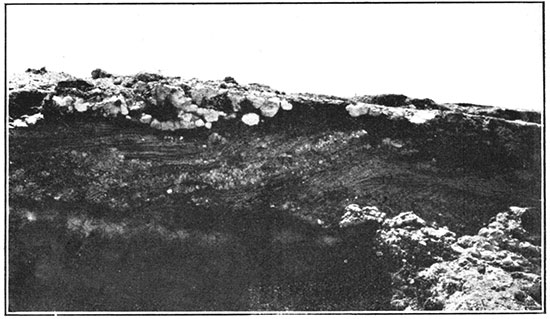
On the higher uplands in the northwestern part of Russell County scattered patches of gravel and grit are found from 70 to 100 feet above the local grade. Two distinct types are recognizable: (1) deposits of grit and clay several feet thick that are more or less closely cemented with calcium carbonate, and (2) a thin veneer of pebbles and cobbles, the largest 6 inches in diameter. These two types appear to grade laterally into each other. The beds of calcareous grit show strong cross-bedding and contain more or less spherical masses of soft, pure lime (Fig. 2). [For an excellent discussion of the origin of calcium carbonate in similar gravels to the west, see: Johnson, W. D.; The high plains and their utilization: U. S. Geol, Survey, 21st Ann. Rept., pt. 4, pp. 639-656; 1900.] The "lime balls" are from 2 to 8 inches in diameter and a few contain small nuclei of hardened calcium carbonate. The pebbles and gravel in the thin layer at the same level consist chiefly of quartzite, dense tan limestone, and nodules of hard calcareous material resembling parts of the Ogallala formation farther west.
Figure 2--High terrace gravels (Ogallala? formation) in sec. 18, T. 13 S., R. 15 W., Russell County. View southward, showing cross-bedding and spherical nodules of calcium carbonate.
These beds occur on a more or less dissected surface that slopes gently southward and eastward from the high divides north of Smoky Hill and Saline rivers and Paradise creek. The gravel in the northwestern part of Russell comity lies on a surface that, south of Saline river, slopes gently south-southeastward toward Smoky Hill river at a rate of slightly more than 10 feet to the mile. This surface, though having little or no gravel on it, is more or less distinctly recognizable nearly to Fossil creek, and its extension would probably be about a hundred feet above the fossil-bearing gravel beds there. The highest elevation at which these high terrace gravels were recognized near Russell County is 2,000 feet above sea level, in sec. 34, T. 12 S., R. 16 W., Ellis County, 2 miles west of Russell County, but they were seen at elevations of less than 1,850 feet at places in northern Russell County.
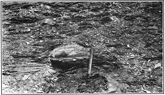
Figure 3--A concretion in the lower part of the Fairport member of the Carlile shale, 10 feet above its base, sec. 3, T. 12 S.; R. 16 W., Ellis County. Note the bending of the shale lamination around the concretion.
The Ogallala formation is widespread in western Kansas as a deposit of coarse materials at high levels. [Darton, N. H.; U. S. Geol. Survey Geol. Atlas, Syracuse-Lakin Folio (No. 212); 1920.] It consists of gravel containing pebbles of igneous rock and much reddish feldspar, sand that is commonly cross-bedded, and clay and silt, and is irregularly cemented with calcium carbonate throughout. [Haworth, Erasmus; Physical properties of the Tertiary: Kansas Univ. Geol. Survey, vol. 2, pp. 247-284; 1897.] The Ogallala formation is the platform of debris built by overladen rivers flowing eastward from the Rocky Mountains, and its upper surface should therefore be nearly a plane. [For an especially complete discussion of the origin of this and related formations, see: Johnson, W. D.; The high plains and their utilization: U. S. Geol. Survey, 21st Ann. Rept., pt. 4, pp. 612-656; 1900.] Elevations throughout western Kansas show that the formation slopes eastward at an average rate of slightly more than 10 feet to the mile. To the west this slope is steeper, but eastward it becomes flatter. The base of the Ogallala is lower in the present large valleys than it is on the divides," indicating that the present main lines of drainage are of pre-Ogallala age. [Darton, N. H.; Syracuse-Lakin Folio (No. 212): U. S. Geol. Survey Geol. Atlas, p. 5; 1920.]
If the formation once extended farther east into Russell County--and it has been recognized north, west and south of there--its elevation should be approximately 2,000 feet in the western part of the county and less than 1,800 feet in the eastern part, lying somewhat lower in the larger valleys than on the broad divides. [Haworth, Erasmus; Special report on the well waters in Kansas (geologic map of Kansas): Univ. Kansas Geol. Survey, Bull. 1, pl. 1; 1913.] The coincidence in elevation and slope, and the striking similarity of the lithology of the high terrace gravels of Russell County to those of the Ogallala formation, appear to justify their correlation with that formation.
Uselessness of Cenozoic Rocks for Structural Mapping
No evidence was found to prove that the Cenozoic beds may not have been warped slightly by earth movements, or by settling of the buried strata during Recent time, but the discontinuity of the deposits and their irregular, unconformable contact with Cretaceous rocks, make them useless for structural mapping.
Prev Page--Introduction || Next Page--Rocks Exposed, Mesozoic
Kansas Geological Survey, Geology
Placed on web March 17, 2014; originally published 1925.
Comments to webadmin@kgs.ku.edu
The URL for this page is http://www.kgs.ku.edu/Publications/Bulletins/10/03_rocks.html