Kansas Geological Survey, Open-file Report 2003-59
by
Evan K. Franseen, Alan P. Byrnes, Jason R. Cansler, D. Mark Steinhauff, Timothy R. Carr, and Martin K. Dubois
KGS Open File Report 2003-59
This report is also available as an Acrobat PDF file.
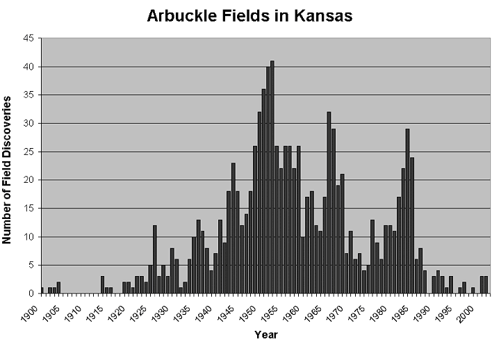
Since the 1910's, several billion barrels of oil have been produced from the Central Kansas Uplift (CKU), primarily from carbonate reservoirs within the Arbuckle and Lansing-Kansas City groups. The majority of Arbuckle reservoirs of central Kansas were drilled prior to 1955 and constitute a series of giant and near giant oil fields (Figure 1).
Figure 1--Plot of number of Arbuckle field discoveries by year. Almost fifty percent of Arbuckle fields were discovered by 1955, which closely coincides with the peak year of discovery (1953). Subsequent secondary discovery peaks occurred in the late 1960's and mid-1980's and can be attributed to new technology and commodity prices.
The significance of the Arbuckle to Kansas production and reserves is highlighted by the estimate that Arbuckle reservoirs have produced about 2.19 billion barrels of oil (BBO) representing approximately 36% of the 6.1 BBO of total Kansas oil production to date (Figure 2). Arbuckle lease oil production is log-linearly distributed with nearly 50% of all production produced by 6% of all leases and approximately 80% produced from 20% of all leases (Figure 3).
Figure 2--Arbuckle reservoirs have produced 2.19 billion barrels of oil (BBO) representing 36% of the 6.1 BBO of total Kansas oil production.
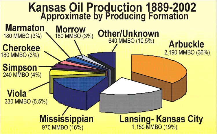
Figure 3--Plot showing that approximately 80% of Arbuckle oil has been produced from 20% of all leases.
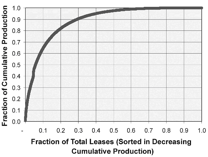
This lopsided distribution of Arbuckle lease productivity is typical of complex natural phenomena. Arbuckle reservoirs produce from 31 counties statewide with a significant portion of the total production coming from the 10 counties in the CKU region (Figure 4). Within the ten county area on the CKU, the Arbuckle has produced over 1,630 MBO, representing 69% of the production from the top four producing intervals in this region (Figure 5).
Figure 4--A, Structure map (subsea elevation) on Arbuckle showing locations of Arbuckle production in Kansas (black). Note most production is associated with structural highs, especially the Central Kansas Uplift. (CKU). B, Arbuckle cumulative oil production county (MMBO) by county. Of the 31 counties in which the Arbuckle has been productive, over 70% of the production has come from the 10 county area coinciding with the CKU.
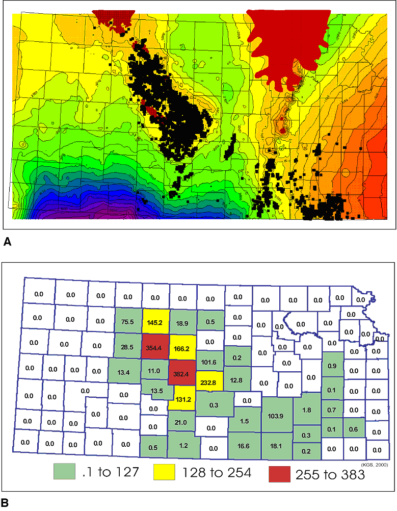
Figure 5--The Arbuckle has produced over 1,629 MMBO in the ten county area on the Central Kansas Uplift, which represents 69% of the production from the top four producing intervals in this region.
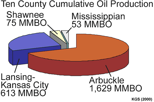
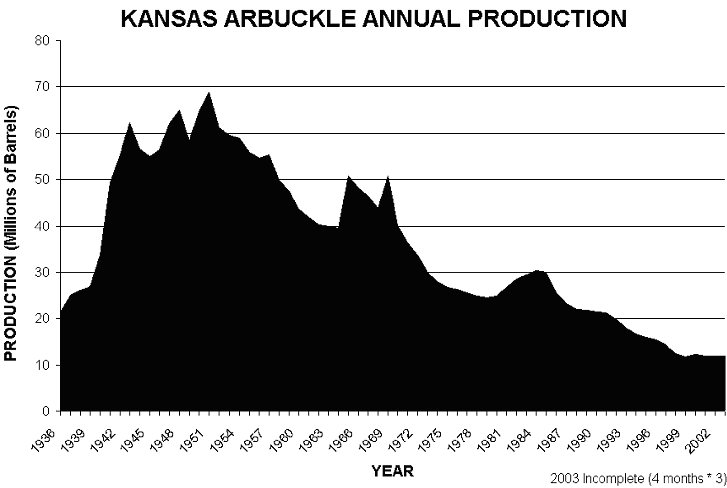
Table 1 lists the 21 most productive Arbuckle fields and the cumulative oil production attributed to each. These fields represent approximately 56% of all Arbuckle production with nineteen of the fields lying on the CKU and the remaining two on the Nemaha Uplift in Butler and Cowley counties. Although the Arbuckle has been a prolific producing interval since 1917, annual production peaked in the early 1950's at more than 68 million barrels and has declined to approximately 12 million barrels per year in 2002 (Figure 6). Today, stripper production dominates Arbuckle production with over 90% of wells producing less than 5 barrels of oil per day and is very sensitive to commodity prices.
Table 1--Twenty-one major Arbuckle fields.
| Field Name | Cumulative Oil (bbl) | Active Wells | Twn Rng | County | Depth |
| CHASE-SILICA | 307,571,872 | 876 | 18S_10W | BARTON, RICE, STAFFORD | 3,328 |
| TRAPP | 300,087,115 | 726 | 15S_14W | BARTON, RUSSELL | 3,252 |
| EL DORADO | 299,365,153 | 618 | 25S-5E | BUTLER | 2,550 |
| BEMIS-SHUTTS | 248,694,147 | 2,150 | 10S-16W | ELLIS/ROOKS | 2,967 |
| HALL-GURNEY | 152,414,246 | 1,107 | 14S-13W | BARTON, RUSSELL | 3,192 |
| KRAFT-PRUSA | 130,826,618 | 700 | 15S-10W | BARTON, ELLSWORTH, RUSSELL | 2,885 |
| GORHAM | 94,783,868 | 369 | 14S-15W | RUSSELL | 3,289 |
| GENESEO-EDWARDS | 85,900,491 | 190 | 18S-8W | ELLSWORTH/RICE | 3,278 |
| FAIRPORT | 58,735,912 | 368 | 12S-15W | ELLIS/RUSSELL | 3,350 |
| BLOOMER | 55,787,569 | 244 | 17S-10W | BARTON/ELLSWORTH/RICE | 3,200 |
| STOLTENBERG | 52,996,954 | 470 | 15S-19W | BARTON/ELLSWORTH | 3,333 |
| RAY | 48,122,148 | 159 | 5S-20W | GRAHAM, NORTON, PHILLIPS, ROOKS | 3,540 |
| AUGUSTA | 47,773,725 | 111 | 28S-4E | BUTLER | 2,600 |
| MOREL | 46,765,270 | 444 | 9S-21W | GRAHAM | 3,718 |
| MARCOTTE | 41,659,245 | 221 | 9S-19W | ROOKS | 3,752 |
| VOSHELL | 36,066,429 | 22 | 20S-3W | MCPHERSON | 3,400 |
| IUKA-CARMI | 34,128,807 | 226 | 27S-13W | PRATT | 4,354 |
| COOPER | 25,486,646 | 112 | 9S-20W | GRAHAM/ROOKS | 3,216 |
| RUSSELL | 23,243,643 | 53 | 13S-14W | RUSSELL | 3,280 |
| GATES | 21,519,184 | 125 | 21S-12W | STAFFORD | 3,679 |
| TRICO | 20,959,428 | 144 | 10S-20W | ELLIS/GRAHAM/ROOKS/TREGO | 3,651 |
| RICHARDSON | 19,843,416 | 75 | 22S-11W | STAFFORD | 3,537 |
| OXFORD | 18,196,474 | 26 | 32S-2E | SUMNER | 2,890 |
| BARRY | 17,812,734 | 132 | 8S-19W | ROOKS | 3,430 |
| MUELLER | 15,950,997 | 105 | 21S-12W | STAFFORD | 3,594 |
| OTIS-ALBERT | 15,278,960 | 22 | 18S-16W | BARTON | 3,703 |
| GALLAH | 14,805,787 | 37 | 12S-21W | TREGO | 3,961 |
| GREENWICH | 14,165,749 | 20 | 26S-2E | SEDGWICK | 3,321 |
| BOYD | 14,055,036 | 54 | 17S-13W | BARTON | 3,438 |
| MAX | 13,344,772 | 63 | 21S-11W | STAFFORD | 3,570 |
| LORRAINE | 12,666,332 | 26 | 17S-9W | ELLSWORTH | 3,200 |
| TOBIAS | 12,521,480 | 20S-9W | RICE | 3,218 | |
| SOLOMON | 12,083,711 | 86 | 11S-19W | ELLIS | 3,629 |
| IRVIN | 11,812,943 | 76 | 13S-19W | ELLIS | 3,860 |
| NORTON | 11,692,977 | 88 | 3S-23W | NORTON | 3,778 |
| DOPITA | 11,321,826 | 131 | 8S-17W | ROOKS | 3,409 |
| HITTLE | 10,542,917 | 240 | 31S-4E | COWLEY | 3,280 |
| NORTHAMPTON | 10,113,608 | 51 | 9S-20W | ROOKS | 3,803 |
| DRACH | 10,016,115 | 23 | 22S-13W | STAFFORD | 3,690 |
| TOTAL | 2,379,114,304 | 10,710 | Note: Many fields produce from multiple
horizons and not all production is Arbuckle |
||
Figure 6--Annual production from Kansas Arbuckle reservoirs. Peak annual production was in 1951 (68,807,787 barrels) and has declined to an estimated 12 million barrels. Production prior to 1936 is not available in annual increments and is not shown
The long production history and exploration/exploitation strategies have led to some commonly held perceptions about Arbuckle reservoir properties. These include:
This paper illustrates some studies on various geologic aspects of the Arbuckle Group in Kansas that demonstrate that the commonly held perceptions are not true everywhere and that Arbuckle reservoir character can be complex. These studies also are providing a clearer picture of the different types of Arbuckle reservoirs, which is becoming increasingly important because the Arbuckle is currently undergoing improved oil recovery (IOR) efforts, and being considered for future CO2 floods, and carbon sequestration. Improved reservoir characterization and IOR efforts could potentially lead to recovery of hundreds of millions of barrels of oil from Arbuckle reservoirs in Kansas.
Kansas is characterized by broad basins and domes covering thousands of square kilometers. Prominent uplift and subsidence occurred episodically throughout the Phanerozoic, separated by periods of gradual deformation (Newell et al., 1989). Although the location of the structural features varied somewhat throughout the Paleozoic, there appear to be consistent patterns of repeated localized uplift and subsidence (Baars and Watney, 1991). Two prominent structural uplifts that affected the Paleozoic rocks in Kansas are the Nemaha uplift and CKU (Figure 7A). Structural maps of Precambrian basement and isopach maps of the Arbuckle indicate the presence of elements of the CKU and Nemaha Ridge prior to Arbuckle deposition. In addition, extensive differential erosion of Precambrian rocks (presumably in late Precambrian time) resulted in an irregular topography onto which Cambro-Ordovician strata were deposited (Walters, 1946).
Figure 7--A, Map of Kansas showing major structural elements. Red dots show locations of Arbuckle cores studied to date. B, Diagrammatic cross section and maps showing locations of cross section in Kansas. Note Arbuckle relationships (blue) to basement rocks (brown) and overlying strata, especially across the CKU (modified from Adler et al., 1971).
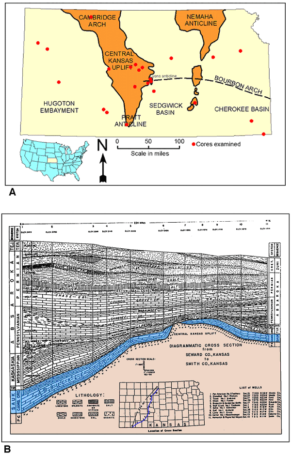
The Midcontinent rift system and related Humboldt fault zone constitute a north-northeast by south-southwest-trending fault swarm that was reactivated several times during the Paleozoic. Local uplift and interstratal truncations suggest rejuvenation of structural blocks during the Late Ordovician (Baars and Watney, 1991). The CKU and Nemaha Ridge became prominent positive structural elements during later significant Early Pennsylvanian deformation likely associated with similarly aged plate convergence along the Ouachita Mountains orogenic belt in Arkansas (Newell et al., 1989). This uplift and erosion locally affected Arbuckle strata, especially on the Central Kansas Uplift where Pennsylvanian strata directly overlie Arbuckle strata or basement rocks where Arbuckle strata are absent (Figure 7B).
The Arbuckle is present in most of Kansas and is absent only in areas of northeastern and northwestern Kansas, and over ancient uplifts and buried Precambrian highs (Walters, 1946; Keroher and Kirby, 1948; Cole, 1962, 1975; Denison, 1966; Figure 7B). The Arbuckle is thin to absent in parts of northeastern Kansas due to pre-Simpson uplift and erosion (Newell et al., 1987). The Arbuckle is locally absent on the Nemaha uplift, Cambridge arch, and Central Kansas uplift due to pre-Pennsylvanian erosion (Walters, 1946; Jewett, 1951, 1954; Merriam, 1963). Arbuckle rocks occur at depths ranging from about 500 feet in southeastern Kansas to more than 7,000 feet in southwestern Kansas (Keroher and Kirby, 1948; Cole, 1975). Arbuckle strata thicken as a whole from north to south and are thickest, up to 1390 feet, in the southeastern corner of Kansas (Cole, 1975).
Near the end of the Early Ordovician, falling sea level drained the continents and left behind a landscape underlain by predominantly carbonate Cambro-Ordovician strata and Precambrian basement rocks. Deep weathering and erosion produced a regional unconformity and a regionally extensive karst system over most of the North American craton. This regional system has been called the Arbuckle-Ellenburger-Knox-Prairie du Chien-Beekmantown-St. George karst plain (Kerans, 1988). A vast system of caves, sinkholes, joint-controlled solution features, and collapse breccias developed. These features are found throughout the Midcontinent in the Arbuckle, Knox, Beekmantown, Prairie du Chien, St. George, and Ellenburger groups (Gore, 1954; Merriam and Atkinson, 1956; Fisher and Barrett, 1985; Kerans, 1990; Hammes, 1997). However, the nature of the post-Sauk unconformity surface is quite variable (Sloss, 1988). In some areas (such as the CKU) there has been extensive erosion during the post-Sauk regression and numerous additional prolonged periods of subaerial exposure up through the Early Pennsylvanian.
Studies over the years have focused on the erosional and karsted nature of the upper Arbuckle surface in Kansas (e.g. Walters, 1946; 1958; 1991). This attention was driven largely by petroleum production in the Arbuckle Group of Kansas, which is associated with the unconformity surface. A recent study by Cansler and Carr (2001) documented details of karst geomorphology of the upper Arbuckle surface at various scales over the southern part of the CKU (Barton, Ellsworth, Rice, and Stafford counties). They identified major karst landform geometries (dolines, cockpits) and karst erosional features related to ground water sapping processes (discussed further in the Discussion section).
Arbuckle Group rocks are part of the craton-wide Sauk Sequence, which is bounded at its base and top by major interregional unconformities (Sloss, 1963). These interregional unconformities represent major regressions of the sea and erosion and subaerial exposure of vast areas of the craton. Arbuckle shallow shelf carbonate strata in Kansas and age-equivalent strata elsewhere are part of the Cambro-Ordovician "Great American Bank" that stretched along the present southern and eastern flanks of the North American craton (Wilson et al., 1991). The bank consists of hundreds of meters of largely dolomitized intertidal to shallow subtidal cyclic carbonates overlain by a regional unconformity (Wilson et al., 1991). The shallow subtidal to intertidal environment persisted throughout Arbuckle depositional time and is reflected in a suite of rocks that are highly heterogeneous, but form a consistent suite found throughout North America (Bliefnick, 1992).
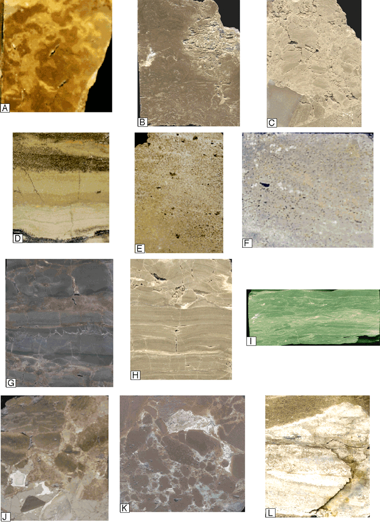
Detailed study of 12 cores from four counties in central Kansas and reconnaissance of about 20 other Arbuckle cores throughout Kansas (Figure 7a) suggest that the facies described in this paper are characteristic of Arbuckle strata in Kansas. Although Arbuckle rocks have been extensively dolomitized, much of the dolomitization is non-fabric destructive, thereby preserving original depositional facies textures. Ten principal facies are evident. Listed in approximate order of relative abundance, with the most abundant facies first, these include:
The first six lithologies listed account for more than 85% of the cored intervals described and the rest account for the remaining 15%.
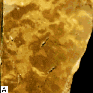 |
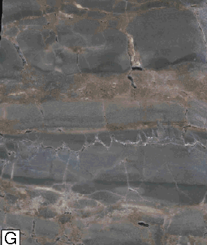
Clotted Algal Boundstone: This facies consists of muddy, peloid-rich mottled (thrombolitic) to wavy laminated clotted algal carbonate lithology (Figure 8A). Other clotted forms (? Renalcis) are also present. Thrombolite-leopard rock texture is typically muddy with some grains. Local burrow mottling is present. Thrombolitic and clotted boundstones have a tightly bound matrix consisting of anhedral, euhedral, and polyhedral dolomite (< 0.5 mm) with peloidal cement. Thrombolitic boundstones typically have excellent sheet-like vuggy and fenestral porosity and poor intercrystalline porosity. Most thrombolitic boundstones were probably deposited in subtidal environments. |
 |
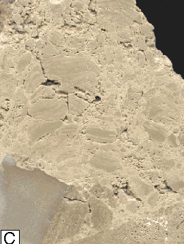 |
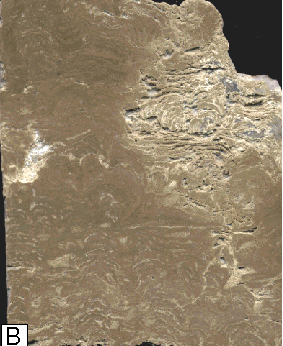
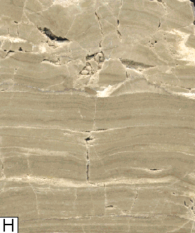
| Laminated Algal Boundstone: This facies consists of wavy laminated algal boundstones and stromatolites with muddy (Figure 8B) to grainy textures (Figure 8C). Current-modified (ripple) lamination occurs locally. Brecciated stromatolite facies typically grades upward to non-brecciated, in-place stromatolites. The stromatolites are locally tightly cemented but commonly contain abundant and distinctive differentially developed intercrystalline, fenestral, keystone vug, and solution enlarged porosity that closely follows laminations. This facies likely represents subtidal to peritidal (where fenestrae are present) environments. This facies is locally oil stained. | |
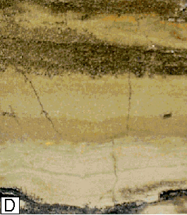 |
Peloidal Packstone-Grainstone: This facies is typically massive, horizontally laminated or bedded (Figure 8D), and commonly interbedded with coarser-grained lithologies. Locally, it contains wispy lenses of shale and interbedded shale layers. Burrow traces and mottling are common. Peloids are abundant and rare interclasts, lumps, and skeletal grains (gastropods) are present. Soft sediment deformation, dewatering or tepee-like structures, mudcracks, and rip-up clasts are locally associated with this facies. The mud-rich peloidal packstone/grainstone facies represents deposition in relatively lower-energy subtidal (massive to burrowed textures) and peritidal (mudcracks, tepees, and rip-up layers and clasts) settings. This rock is tightly bound consisting of anhedral, euhedral, and polyhedral dolomite (< 0.5 mm) and peloidal cement. |
 |
Mixed Packstone-Grainstone: This facies is typically massive, horizontally bedded or crossbedded (Figure 8E), and typically interbedded with ooid packstone-grainstone and wackestone-packstone facies. Grains include intraclasts, skeletal and algal fragments, ooids, peloids, and lumps. This facies indicates higher energy deposition in subtidal to peritidal (fenestrae and keystone vugs) settings. Locally, packstone-grainstone is tightly cemented by euhedral dolomite (< 0.5 mm). However, this facies typically has good intercrystalline porosity. In some rocks the original cement between grains has been leached creating interparticle porosity that is open or filled with chert. The chert has a "chalky" appearance and is porous but exhibits low permeability. |
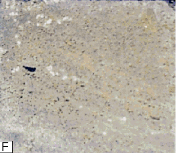 |
Ooid Packstone-Grainstone: This facies (Figure 8F) is typically massive, horizontally bedded or crossbedded, and typically interbedded with wackestone-packstone facies. Dominant grains are ooids, but other grains including intraclasts, skeletal and algal fragments, peloids, and lumps occur in varying abundance. This facies indicates higher energy deposition in subtidal to peritidal (fenestrae and keystone vugs) settings. This facies typically has good inter-crystalline porosity, but locally is tightly cemented by euhedral dolomite (< to 0.5 mm). In some rocks the original cement between grains has been leached creating interparticle porosity that is open or filled with chert. This chert has a "chalky" appearance and is porous but exhibits low permeability. |
 |
 |
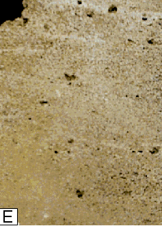
| Wackestone-Mudstone: This facies is typically massive to horizontally laminated (Figures 8G, 8H). Burrow mottling is typically present in most intervals. This facies typically is composed of euhedral dolomite (< 0.05 mm) with little or no porosity. Replacement of evaporite nodules with chert is observed locally. This facies is interpreted as being deposited in shallow-water, low-energy restricted environments. | |
 |
|
| Intra-Arbuckle Shale: Some shales are interbedded with carbonate rocks suggesting they were deposited during Arbuckle deposition (Figure 8I). In addition, horizons with wavy horizontal to horizontally interbedded shale and carbonate mudstone-wackestone are present. Several shale layers contain silicified nodules and lenses that may have replaced evaporites. These shale layers likely represent relatively low energy subtidal to peritidal conditions. Supratidal conditions may be indicated for some horizons where silicified nodules apparently represent replacement of original evaporite minerals. | |
 |
|
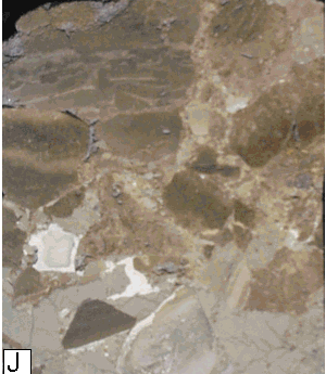
| Conglomerate and Breccia: Many conglomerates or breccias consist of rip-up clasts derived from underlying lithologies. Textures range from clast- to matrix-supported. Conglomerates and breccias are commonly associated with desiccation and mud cracks, dewatering structures, and tepees. Local autoclastic breccia textures indicate subaerial exposure of some Arbuckle horizons. Some collapse breccia may have resulted from the dissolution of evaporites. These conglomerates evidence intra-Arbuckle high-energy erosional and subaerial exposure events in subtidal to peritidal settings. The conglomerate and breccia facies typically has variable porosities and permeabilities that are primarily a function of the lithologies that were brecciated. Later brecciation and fracturing occurs with various textures ranging from incipient fracturing and brecciation with a fitted clast texture to extreme brecciation with chaotically oriented clasts of various lithologies (Figure 8J). The features are consistent with a karst origin from exposure at the post-Sauk unconformity. These late-stage breccias and fractures are variably open to tight. | |
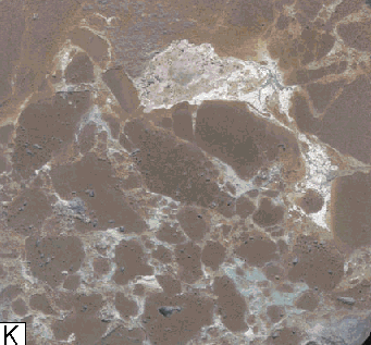 |
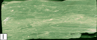
Fracture-fill Shale: Much of the shale is green and clearly present as fracture (Figure 8K) or cave fill, with sediment originating from above the upper Arbuckle unconformity surface. Locally, fracture fills contain fragments of dolomite rhombs and subangular to rounded silt-size to coarse-grained detrital quartz grains. |
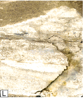 |
Chert: Chert commonly occurs as a replacement of carbonate facies (typically preserving original textures) and, locally, original evaporite minerals. Chert replacement commonly results in tight and impermeable areas (Figure 8L). Locally, where only partial replacement occurs, some vuggy and intercrystalline porosity is developed. |
The striking feature in many cores is the abundance and apparent importance of "matrix" porosity (intercrystalline, moldic, fenestral, vuggy) throughout the entire lengths of the cores, which is related to depositional facies, early diagenesis, and dolomitization and not necessarily related to the upper post-Sauk subaerial exposure surface. The relative lack of karst associated fracture, breccia, and dissolution porosity in most cores is especially surprising considering that the cores came from flanks or tops of structural highs where karst processes would likely have been most extensive.
Observations indicate that more than 50% of the preserved porosity is "matrix" porosity. Much of the matrix porosity-rich intervals are associated with coarse-grained, laminated to bedded facies that are differentially cemented or with stromatolitic intervals that show differential porosity development likely due to differences in original texture (e.g. mud content) and early diagenesis (e.g. development of fenestral and vuggy porosity during early subaerial exposure events).
Figure 8--Core photographs of major Arbuckle facies. Note the width of cores in each photo is approximately 3.5 inches. A, Clotted Algal Boundstone. This facies consists of muddy, peloid-rich mottled (thrombolitic) to wavy laminated clotted algal carbonate lithology. Porosities are generally less than 6% and permeabilities are below 0.1 md. B, Laminated Algal Boundstone (muddy). This facies consists of wavy laminated algal boundstones and stromatolites. Porosities are generally less than 6% and permeabilities are below 0.1 md. C, Laminated Algal Boundstone (grainy). This facies consists of wavy laminated algal boundstones and stromatolites, and represents some of the best reservoir rock with porosity up to 32% and permeability up to 1,500 md. D, Peloidal Packstone-Grainstone. This facies is typically massive, horizontally laminated or bedded. Porosities range from 0% to 4% and absolute permeabilities range from 0.0003 md to 0.1 md but are generally below 0.005 md. E, Packstone-Grainstone. This facies is typically massive, horizontally bedded or crossbedded. Porosities range from 6%, to 18%, and permeabilities range from 0.1 md to 50 md. F, Ooid Packstone-Grainstone. This facies is typically massive, horizontally bedded or crossbedded. Porosities range from 11% to 30%, and permeabilities range from 10 md to 1,500 md. G, Wackestone: This facies is typically massive to horizontally laminated. Porosities range from 2% to 11% and permeabilities range from 0.01md to 1 md. H, Mudstone: This facies is typically massive to horizontally laminated. Porosities range from zero to 10% and absolute permeabilities range from <0.0001 md to 0.1 md. I, Intra Arbuckle Shale: Some shales are interbedded with carbonate rocks suggesting they were deposited during Arbuckle deposition. Shales are tight and represent permeability barriers. J, Breccia: Brecciation and fracturing occurs with various textures. This example shows chaotically oriented clasts of various lithologies. Breccia facies typically have variable porosities and permeabilities that are primarily a function of the lithologies that were brecciated. K, Fracture-fill Shale: Much of the shale is green and clearly present as fracture or cave fill, with sediment originating from above the upper Arbuckle unconformity surface. This shale occludes original fracture porosity. L, Chert: Chert (white area) locally occurs as a replacement of carbonate facies. Chert replacement commonly results in tight and impermeable areas.
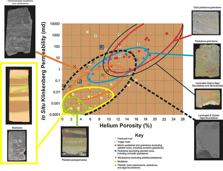
This section summarizes results of core-plug petrophysical studies from Byrnes et al. (1999), which emphasize the important contribution of original facies character and matrix properties to reservoir character (Figure 9).
Cementation of matrix has resulted in nearly total occlusion of porosity. Porosities range from 0% to 4% and absolute permeabilities range from 0.0003md to 0.1md but are generally below 0.005 md. Fenestrae within this facies may range up to several centimeters in length and may enhance porosity by several percent. Fenestrae in this lithology are not interconnected but are isolated by low permeability matrix.
Without fractures or fenestrae these exhibit porosities ranging from zero to 10% and absolute permeabilities ranging from <0.0001 md to 0.1 md. Where fenestrae are present, porosity may be enhanced up to values as high as 17%, however, the fenestrae are primarily isolated and permeabilities are not increased significantly.
Without vugs these exhibit porosities ranging from 2% to 11% and permeabilities ranging from 0.01 md to 1 md. Where vugs are present, porosities can range from 9% to 17% and permeabilities can range from 1md to 1,000 md. Where vuggy porosity is developed these may exhibit high permeability at the core-scale but laterally pervasive connection of vugs may not exist at the interwell scale.
Porosities range from 6%, for finer-grained rock and where packstone is mottled with wackestone, to 18% for cleaner more coarse-grained rock. Permeabilities in the packstone lithology range from 0.1 md to 50 md.
Generally these contain little to no vuggy porosity but exhibit intercrystalline and moldic porosities ranging from 11% to 30%, associated permeabilities range from 10 md to 1,500 md. The highest porosity and permeability values are exhibited by clean, homogeneous, medium-grained moldic packstones.
Muddy algal boundstones exhibit porosities generally less than 6% and permeabilities below 0.1 md. Where fenestral or vuggy porosity is developed these may exhibit high permeability at the core-scale but it is unlikely that these high permeabilities are laterally pervasive at the interwell scale.
Laminated grainy algal boundstones represent some of the best reservoir rock ranging in porosity up to 32% and permeability up to 1,500 md.
Petrophysics of lithofacies at the core-plug scale, and for many lithologies at the whole-core scale, are dominantly controlled by grain size. Each lithology exhibits a generally unique range of petrophysical properties modified by the presence of fractures, vuggy porosity, and grain size variation within the lithologic class. Facies comprising multiple lithologies of differing grain size exhibit bulk properties that are scale-dependent and are a function of the architecture of the constituent facies. All lithologies exhibit increasing permeability with increasing porosity and can be broadly characterized as lying along the same general porosity-permeability trend (Figure 9). Variance in permeability for any given porosity is approximately two orders of magnitude and may be primarily attributed to the influence of such lithologic variables as the ratio and distribution of matrix and fenestral/vuggy porosity, grain size variations, and subtle mixing or interlamination of lithologies.
Fracturing of lithologies enhances permeability directionally but does not add significantly to porosity (Figure 9). Vuggy porosity (even up to as high as 8%) is largely isolated in mudstones, but is better connected in wackestones. Vuggy pores can be well connected where vuggy porosity is extensive near the unconformity surface.
Figure 9--Core-plug Petrophysics. Petrophysical properties of the facies at the core plug scale are generally controlled by matrix grain size. Each lithology exhibits a generally unique range of petrophysical properties. All lithologies exhibit increasing permeability with increasing porosity and can be characterized as lying along the same general porosity permeability trend. Note that fracturing of lithologies enhances permeability but does not add significantly to porosity. Vuggy pores can be well connected where vuggy porosity is extensive near the unconformity surface.
It is well documented that Arbuckle Group and equivalent-age rocks from outside of Kansas are platform deposits dominated by ramp-type subtidal to peritidal carbonates, which can be subdivided into cycles based on facies type and depositional patterns. Individual cycles (from less than 0.5 m to 40 m thick) in other areas are numbered at between 350-450 (e.g. Wilson et al., 1991). These individual cycles have recently been shown to stack into cycle sets or bundles.
Franseen (1994; 2000) and Steinhauff et al. (1998) noted the similarity of Arbuckle facies and cycles in Kansas cores to areas outside of Kansas. They documented the existence of subtidal to peritidal cycles (on a scale of less than three feet to over twenty feet thick), and cycle sets in Arbuckle cores. This arrangement of reservoir and non-reservoir facies results in complex vertical heterogeneity at several scales. To illustrate this heterogeneity, potential reservoir facies versus non-reservoir facies are highlighted in a core from the Lyons Field in Rice County (Figure 10).
Figure 10--Core description from the #1 Madsen well in Lyons Field, Rice County. Potential reservoir facies (algal boundstones = green; packstone/grainstones = blue) are highlighted from non-reservoir facies (wackestone = tan; mudstone = yellow; shale = black) to illustrate different scales of packaging of lithofacies. At least three scales are evident. One scale is in the range of several 10's of feet to over 100 feet. A second scale occurs in the range of several 10's of feet, and a third scale occurs in the range of several feet to less than 1 foot. This alternation of potential reservoir and non-reservoir strata at different scales creates complex vertical heterogeneity.
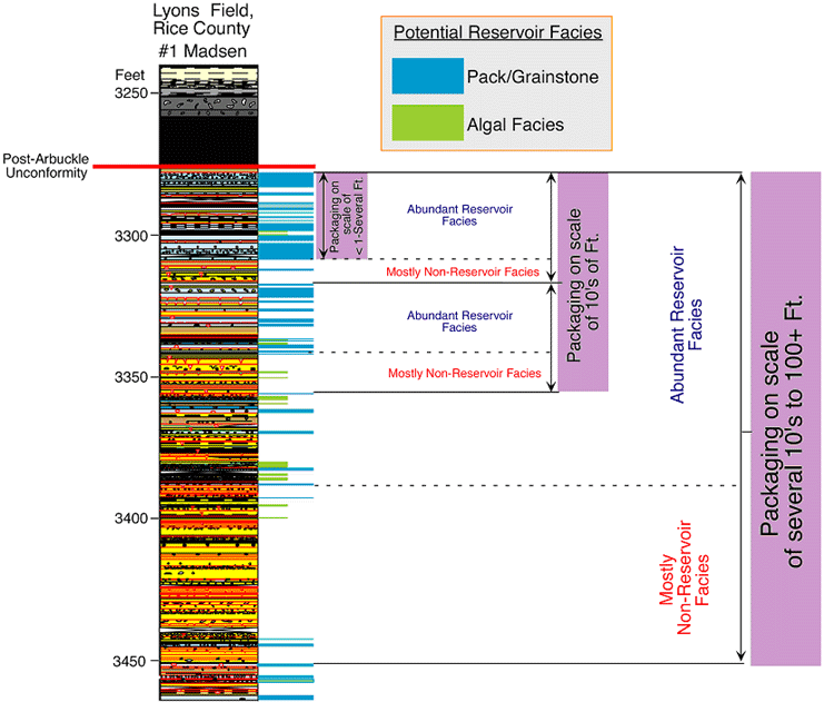
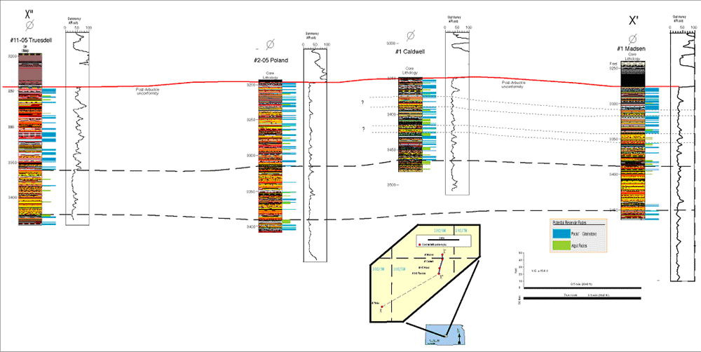
Packaging of "mostly non-reservoir facies" versus "abundant potential reservoir facies" occurs on a scale of several tens to over one hundred feet, another scale of tens of feet, and a third scale of less than one foot to several feet. Nearby cores from the same field (Lyons Field) in Rice County show a similar range in scales of vertical packaging. It also appears that packages of reservoir and non-reservoir intervals at several scales may be laterally persistent (Figure 11), which suggests that some Arbuckle strata could have persistent lateral flow patterns. This is supported by modeled permeabilities based on upscaled core and log data (discussed further in the Discussion section), which indicate that laterally persistent stratal packages exert significant control on flow properties.
Figure 11--Cross section illustrating vertical and lateral distribution of reservoir and non-reservoir facies in Lyons Field, Rice County. The Madsen #1 core of Figure 8 is on the far right. Note that the dashed lines are not necessarily exact chronostratigraphic correlations but are drawn to illustrate that some of the stratal packages at several different scales appear to be laterally continuous across much of the field. Modeled permeabilities based on upscaled core and log data indicate that laterally persistent stratal packages exert significant control on flow properties.
The dominance of matrix porosity (intercrystalline, moldic, fenestral, vuggy) related to depositional facies, early diagenesis, and dolomitization, and the control of laterally persistent stratal packages on flow properties is a departure from the perception that karst is the only control on reservoir properties, and emphasizes the importance of understanding facies distribution. For example, the packstone-grainstone and boundstone reservoir facies are much more likely to be favorable reservoirs where they intersect the unconformity as compared to where other non-reservoir facies intersect the unconformity. In addition, the facies distributions in potentially laterally continuous beds of various scales may have implications for deeper reservoir zones.
Some recent studies indicate that there is notable variability in connectivity of uppermost oil-productive Arbuckle strata with the underlying aquifer, which is a significant departure from the commonly accepted paradigm of the presence of a strong bottom water drive. Analysis of infill well Drill Stem Test (DST) pressures in several major mature fields provides an indication of the vertical connectivity of the Arbuckle. In reservoirs well connected to the underlying aquifer system, DST pressures in producing fields remain similar to the aquifer pressures (approximately 1,100 pounds per square inch, psi). Reservoirs that are poorly connected or are not connected to the underlying aquifer exhibit low infill well DST pressures below aquifer pressures (generally ranging from 900 psi down to <250 psi, respectively). These low pressures, resulting from field production, are sustained by the inability of the underlying aquifer to recharge reservoir pressures due to limited connectivity.
The Bemis-Shutts Field, Ellis County, Kansas illustrates the nature of variable aquifer connectivity in the Arbuckle on a local scale (Figure 12). Pressures found in some of the wells, which were drilled decades after initial production are significantly less than original bottom hole pressure (1,100 psi). Whereas the Arbuckle is below hydrostatic equilibrium pressure in Kansas (0.433 psi/ft), final shut-in pressures for thousands of Arbuckle wells exhibit a wide distribution, with a significant number exhibiting pressures less than half the regional hydrostatic pressure (Figure 13). Although some low pressures result from poor reservoir permeability and lack of complete DST equilibration, initial and ongoing production from the reservoirs tested supports the interpretation that many low pressures reflect actual reservoir conditions and poor connection to the underlying aquifer.
The variability in connection of upper Arbuckle strata to the underlying aquifer likely is due to a combination of structural, stratigraphic, karst, and other diagenetic controls. Detailed integrative studies can aid in understanding these controls on connectivity and provide predictive capabilities. An example is provided by Cansler and Carr (2001). They studied details of karst geomorphology of the upper Arbuckle surface at various scales, over the southern extent of the CKU (Barton, Ellsworth, Rice, and Stafford counties). In that study, the correspondence of Sub-Pennsylvanian Arbuckle topography with Precambrian basement structural features was evaluated by superimposing structure contours of the top of the Precambrian surface, and interpreted lineaments from gravity and magnetics maps on the structure contour map on the top of the Arbuckle. This analysis indicated that, although the Sub-Pennsylvanian surface does not perfectly mimic the basement structure, when recognized, basement structure has a significant influence on alignment of karst and drainage features on the Arbuckle erosion surface.
Two different styles of erosional terrains were identified on the Sub-Pennsylvanian Arbuckle surface, a polygonal karst terrain (cockpit karst) and plateau-like erosional features modified by ground water sapping (sapped plateaus). The two types of erosional terrains can be considered to represent end members of the range of karst terrains and numerous intermediate examples exist. The following is a brief discussion of the two end-member karst terrains. Further details can be found in Cansler and Carr (2001). Cockpit karst is characterized by star-shaped depressions with a slightly concave floor. The closed depressions in cockpit karst landscapes behave as small river basins, characterized by intermittent and centripetally directed flow down poorly developed channels (Williams, 1972). Cockpit karst landscapes are visually dominated by the residual hills that occur between a system of closed depressions and these topographic divides can be polygonal in shape (Figure 14).
Sapped plateaus (Figure 15) form when exposed joints concentrate surface runoff, which is rapidly diverted into the ground-water system and flows in the subsurface through a high permeability bed overlying an aquitard down the local dip of the beds. Sapping occurs locally at sites where ground water emerges just above lithologic discontinuities (permeability barriers). Ground water emerging from these seepage springs slowly removes material that provides the basal support for the cliffs and slopes. Slope failure occurs as the scarp is undermined, allowing debris to accumulate at the base of the slope. As headward migration continues to a mature stage, the drainage basins interact, resulting in lightbulb-shaped areas in up-dip parts of the drainage basin. Water migration though initial high permeability beds can further enhance porosity and permeability in these carrier beds.
Cansler and Carr (2001) recognized differences in oil productivity and drill stem test data from relatively recent (1960-present) infill wells between cockpit terrains and sapped plateau regions. Relatively small, irregularly shaped fields that occur in mature cockpit landscapes experience relatively low cumulative production per well (typically 50,000-100,000), whereas fields that occur on ground-water sapped plateaus show significantly higher per well cumulative hydrocarbon recovery (200,000-300,000). In general, infill wells located in areas dominated by cockpit karst experienced relatively high final shut in pressures (1,000-1,200 psi) and infill wells located on sapped plateaus were characterized by significantly lower final shut in pressures (250-750 psi).
Based on these data, inferences can be made as to the relative controls of structure and stratigraphy. Cockpit karst forms are indicative of dominant vertical ground water flow and may be indicative of areas with relatively abundant through-going vertical fractures related to structure. Relatively high DST pressures are supportive of through-going fractures that provide good connectivity to the underlying aquifer. It is suggested here that the relatively low production is likely related to both the small, irregular hills characteristic of cockpit karst that are more or less isolated, and to the influence of the high vertical fracture-related water production on production practices, and economics of abandonment.
In contrast, sapped plateaus indicate a combined stratigraphic and structural control. Although faults and fractures are responsible for plateau development and alignment of erosional features, these areas may indicate a relatively lesser abundance of through going fractures. In the sapped plateau areas, the stratigraphic permeability barriers (non-reservoir facies, shales) that diverted downward flowing water are likely to reduce vertical permeability and connectivity with the underlying aquifer, thereby preventing a strong bottom water drive. The relatively low DST pressures in sapped plateau terrains support this interpretation. It is suggested here that the relatively high production rates in sapped plateau areas is likely related to several factors. Compared to cockpit karst areas, sapped plateau areas are typically characterized by broader high areas (plateaus) covering larger areas (draining a larger area). In addition, the groundwater that flowed along permeability barriers likely enhanced permeability and porosity of the carrier beds.
Our recent efforts have explored upscaling and integrating plug to well-scale petrophysics with detailed sedimentology to quantify the relative role of fracture, vug and matrix properties in Arbuckle reservoirs (Byrnes et al., 1999). This integrated approach has implications for: 1) understanding correlations between lithofacies and petrophysical properties; 2) developing a model to understand how core and DST permeabilities relate in laterally extensive cyclic carbonate strata (such as the Arbuckle); 3) developing a quantitative model for upscaling core permeability in laterally extensive cyclic carbonate strata; 4) providing insight on the potential for deeper Arbuckle traps; 5) information for determining when alternate production or IOR strategies, such as polymer modification or horizontal drilling may be warranted; and 6) developing an integrative approach to understanding geologic, core, log, and DST data.
Whereas good examples of wells where full integration can be performed are limited, initial results of integrated petrophysical studies of Arbuckle strata indicate that well production, particularly in sapped plateau terrain reservoirs, can be explained by matrix-scale permeability (plug to full-diameter core) and variations in permeability between lithofacies. Although the open-hole productive interval in a well consists of interbedded reservoir and non-reservoir intervals, total flow represents the cumulative flow that would be predicted by the permeability-height (kh) of the total interval and primarily the permeability of the thin reservoir beds.
Reservoir rock lithofacies, exhibiting porosities from 10-25% and permeabilities from 10 to 1,500 millidarcies, include laminated grainy algal boundstones and moldic packstone and grainstone. Non-reservoir rock lithofacies include mudstone, peloidal wackestone and packstone, muddy algal boundstone, and chert. In some cores, vugs locally enhance whole-core permeabilities up to 10 times. Where full-diameter core and drill-stem test permeabilities are not consistent, higher drill-stem permeabilities aid in identifying and quantifying fracture-related flow.
In unfractured strata, differences between core and DST permeabilities may be explained by differences in flow-model assumptions and data averaging methods. Geometric mean permeabilities, which mathematically represent random regional distribution of the permeabilities averaged, do not appear to accurately represent the layered flow system. Arithmetic mean permeabilities, which represent an average of a parallel flow system, are more consistent with the conceptual flow model for the Arbuckle system and provide better correlation with DST-calculated permeabilities. Modeled permeabilities based on upscaled core and log data indicate that small-scale laterally persistent stratal packages exert significant control on flow properties of the entire Arbuckle section. Integration of lithologic, stratigraphic and petrophysical data at the plug, whole-core, and drill-stem test scales allows separation of the relative contributions of fractures, vugs, and matrix properties to reservoir flow.
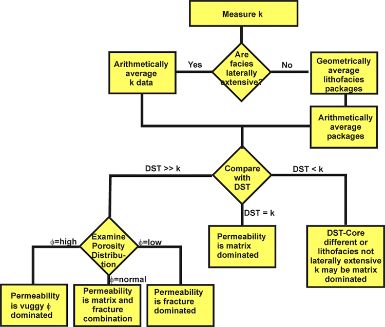
Work is still on-going for testing the upscaling and modeling concepts and methodology. Arithmetic averaging of permeabilities and the use of the permeability-porosity trend has provided a significantly better correlation between DST and smaller-scale permeabilities. In the current methodology for quantifying the relative roles of matrix, vug, and fracture flow, the range of conditional inputs and analyses can be roughly characterized using a simple Boolean model (Figure 16).
Figure 16--Boolean model for quantifying the relative roles of matrix, vug, and fracture flow.
The various aspects of research on Arbuckle strata in Kansas are providing insight on Arbuckle reservoir character and directions for future research to improve the emerging picture of Arbuckle reservoir types. Arbuckle strata consist of complex stacks of reservoir and non-reservoir lithologies at various frequency and thickness scales. Knowing this, the Arbuckle in Kansas can be viewed as having three end-member reservoir architectures, representing fracture-, karst-, and matrix-dominated architectural systems (Figure 17), with numerous possible variations between these end-member architectures. Notably, in all three architectures, lithofacies and stratal packaging of reservoir and non-reservoir strata exert a control on reservoir architecture, despite other processes that affect the rocks.
Figure 17--End-member Arbuckle reservoir types. A) Abundant fracturing of strata. Lithofacies control porosity and permeability within individual layers (beds), but fractures dominate overall permeability. B) Karst overprinting on lithofacies and fractures, resulting in complex porosity and permeability. Karst overprinting can vary laterally from insignificant to extensive. Even where extensively developed, karst processes can both enhance and destroy reservoir properties. C) Lithofacies control porosity and permeability, and laterally persistent stratal packages may exert significant control on flow properties.
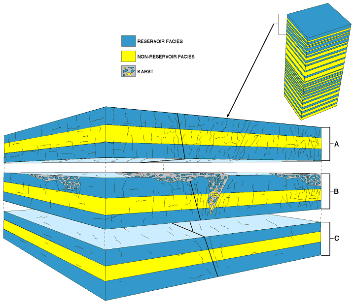
The first end-member type is dominated by fractures, possibly related to faults in structurally complex areas (Figure 17A). In this type of reservoir scenario, lithofacies control porosity and permeability within individual layers (beds), but fractures dominate overall permeability.
The second end-member type of reservoir is the classic conceptual reservoir model for Arbuckle strata in Kansas. In this scenario processes associated with karst overprint lithofacies and fractures, resulting in complex porosity and permeability (Figure 17B). However, karst overprinting can vary laterally from being extensive to insignificant. Also, even where extensively developed, karst processes can both enhance or destroy reservoir properties. For example, open fractures, caves, and vugs in reservoir facies near the unconformity may enhance permeability. However, open fractures and vugs in non-reservoir facies are likely to be insignificant in enhancing overall reservoir character. This emphasizes the importance of understanding which lithologies intersect the unconformity. Additionally, infilling of fractures and vugs with karst sediment and cement associated with karst can completely destroy reservoir properties, even in favorable reservoir facies.
The third end-member type of reservoir shows relatively little fracturing and karst overprinting (Figure 17C). In this reservoir type, lithofacies control porosity and permeability, and laterally persistent stratal packages may exert significant control on flow properties. These types of reservoirs may be significant, especially where karst overprinting is not extensive, in areas away from faults, in areas off structural highs, and stratigraphically deeper within the Arbuckle.
Our recent efforts have explored upscaling and integrating plug to well-scale petrophysics with detailed sedimentology to quantify the relative role of fracture, vug and matrix properties in Arbuckle reservoirs (Byrnes et al., 1999). This integrated approach has implications for:
Whereas good examples of wells where full integration can be performed are limited, initial results of integrated petrophysical studies of Arbuckle strata indicate that well production, particularly in sapped plateau terrain reservoirs, can be explained by matrix-scale permeability (plug to full-diameter core) and variations in permeability between lithofacies. Although the open-hole productive interval in a well consists of interbedded reservoir and non-reservoir intervals, total flow represents the cumulative flow that would be predicted by the permeability-height (kh) of the total interval and primarily the permeability of the thin reservoir beds.
Reservoir rock lithofacies, exhibiting porosities from 10-25% and permeabilities from 10 to 1,500 millidarcies, include laminated grainy algal boundstones and moldic packstone and grainstone. Non-reservoir rock lithofacies include mudstone, peloidal wackestone and packstone, muddy algal boundstone, and chert. In some cores, vugs locally enhance whole-core permeabilities up to 10 times. Where full-diameter core and drill-stem test permeabilities are not consistent, higher drill-stem permeabilities aid in identifying and quantifying fracture-related flow.
In unfractured strata, differences between core and DST permeabilities may be explained by differences in flow-model assumptions and data averaging methods. Geometric mean permeabilities, which mathematically represent random regional distribution of the permeabilities averaged, do not appear to accurately represent the layered flow system. Arithmetic mean permeabilities, which represent an average of a parallel flow system, are more consistent with the conceptual flow model for the Arbuckle system and provide better correlation with DST-calculated permeabilities. Modeled permeabilities based on upscaled core and log data indicate that small-scale laterally persistent stratal packages exert significant control on flow properties of the entire Arbuckle section. Integration of lithologic, stratigraphic and petrophysical data at the plug, whole-core, and drill-stem test scales allows separation of the relative contributions of fractures, vugs, and matrix properties to reservoir flow.
Work is still on-going for testing the upscaling and modeling concepts and methodology. Arithmetic averaging of permeabilities and the use of the permeability-porosity trend has provided a significantly better correlation between DST and smaller-scale permeabilities. In the current methodology for quantifying the relative roles of matrix, vug, and fracture flow, the range of conditional inputs and analyses can be roughly characterized using a simple Boolean model (Figure 16).
The various aspects of research on Arbuckle strata in Kansas are providing insight on Arbuckle reservoir character and directions for future research to improve the emerging picture of Arbuckle reservoir types. Arbuckle strata consist of complex stacks of reservoir and non-reservoir lithologies at various frequency and thickness scales. Knowing this, the Arbuckle in Kansas can be viewed as having three end-member reservoir architectures, representing fracture-, karst-, and matrix-dominated architectural systems (Figure 17), with numerous possible variations between these end-member architectures. Notably, in all three architectures, lithofacies and stratal packaging of reservoir and non-reservoir strata exert a control on reservoir architecture, despite other processes that affect the rocks.
The first end-member type is dominated by fractures, possibly related to faults in structurally complex areas (Figure 17A). In this type of reservoir scenario, lithofacies control porosity and permeability within individual layers (beds), but fractures dominate overall permeability.
The second end-member type of reservoir is the classic conceptual reservoir model for Arbuckle strata in Kansas. In this scenario processes associated with karst overprint lithofacies and fractures, resulting in complex porosity and permeability (Figure 17B). However, karst overprinting can vary laterally from being extensive to insignificant. Also, even where extensively developed, karst processes can both enhance or destroy reservoir properties. For example, open fractures, caves, and vugs in reservoir facies near the unconformity may enhance permeability. However, open fractures and vugs in non-reservoir facies are likely to be insignificant in enhancing overall reservoir character. This emphasizes the importance of understanding which lithologies intersect the unconformity. Additionally, infilling of fractures and vugs with karst sediment and cement associated with karst can completely destroy reservoir properties, even in favorable reservoir facies.
The third end-member type of reservoir shows relatively little fracturing and karst overprinting (Figure 17C). In this reservoir type, lithofacies control porosity and permeability, and laterally persistent stratal packages may exert significant control on flow properties. These types of reservoirs may be significant, especially where karst overprinting is not extensive, in areas away from faults, in areas off structural highs, and stratigraphically deeper within the Arbuckle.
Adler, F.J., 1971, Future petroleum provinces of the mid-continent, region 7: in Future Petroleum Provinces of the United States--Their Geology and Potential: Am. Assoc. of Petroleum Geoloigists, Memoir 15, p. 985-1120.
Baars, D.L., and Watney, W.L., 1991, Paleotectonic Control on Reservoir Facies: in Franseen, E.K., Watney, W.L., Kendall, C.G.St.C, and Ross, W., eds., Sedimentary Modeling: Computer Simulations and Methods for Improved Parameter Definition, Kansas Geological Survey, Bulletin 233, p. 253-262.
Bliefnick, D.M., 1992, Karst Related Diagenesis and Reservoir Development in the Arbuckle Group, Paschall #2 Core, Wilburton Field, Oklahoma: Permian Basin Section, Society of Economic Paleontologists and Mineralogists, Pub. No. 92-33, p. 137-152.
Byrnes, A.P., Franseen, E.K., and Steinhauff, D.M., 1999, Integrating Plug to Well-scale Petrophysics with Detailed Sedimentology to Quantify Fracture, Vug and Matrix Properties in Carbonate Reservoirs: An Example from the Arbuckle Group, Kansas: Kansas Geological Survey, Open-File Report 99-47. [available online]
Cansler, J.R. and Carr. T.R., 2001, Paleogeomorphology of the Sub-Pennsylvanian Unconformity of the Arbuckle Group (Cambrian-Lower Ordovician): Kansas Geological Survey, Open-file Report 2001-55. [available online]
Cole, V.B., 1962, Configuration of the Precambrian basement rocks in Kansas: Kansas Geological Survey, Oil and Gas Invest. No. 26, map.
Cole, V.B., 1975, Subsurface Ordovician-Cambrian rocks in Kansas: Kansas Geological Survey, Subsurface Geol. Series 2, 18 p. [available online]
Denison, R.E., 1966, Basement rocks in adjoining parts of Oklahoma, Kansas, Missouri, and Arkansas: Kansas Geological Survey, Open-file Rep. 66-1, 292 p.
Fisher, J.H., and Barrett, M.W., 1985, Exploration in Ordovician of Central Michigan basin: Am. Assoc. of Petroleum Geologists, Bull., v. 69, p. 2065-2076.
Franseen, E.K., 1994, Facies and porosity relationships of Arbuckle Strata: initial observations from two cores, Rice and Rush Counties, Kansas: Kansas Geological Survey, Open-File Rep. 94-53, 34 p.
Franseen, E.K., 2000, A Review of Arbuckle Group Strata in Kansas from a Sedimentologic Perspective: Insights for Future Research from Past and Recent Studies: The Compass, Journal of Earth Sciences Sigma Gamma Epsilon, vol. 75, nos. 2 and 3, p. 68-89.
Gore, G.E., 1954, Cave sandstones in Cotter Dolomite, northeastern Oklahoma: Tulsa Geol. Society, Digest, v. 20, p. 144-179.
Hammes, U., 1997, Electrical imaging catalog: microresistivity images and core photos from fractured, karsted, and brecciated carbonate rocks: Texas Bur. of Economic Geology, Geol. Circ. 97-2, 40 p.
Jewett, J.M., 1951, Geologic structures in Kansas: Kansas Geological Survey, Bulletin 90, pt. 6, p. 105-172. [available online]
Jewett, J.M., 1954, Oil and gas in eastern Kansas: Kansas Geological Survey, Bulletin 104, 397 p.
Kerans, C., 1988, Karst-controlled reservoir heterogeneity in Ellenburger Group Carbonates of West Texas: Am. Assoc. of Petroleum Geologists, Bull., v. 72, no. 10, p. 1160-1183.
Kerans, C., 1990, Depositional systems and karst geology of the Ellenburger Group (Lower Ordovician) subsurface West Texas: Bureau of Economic Geology, University of Texas Report of Investigations 193, 63 p.
Keroher, R.P., and Kirby, J.J., 1948, Upper Cambrian and Lower Ordovician Rocks in Kansas: Kansas Geological Survey, Bulletin 72, 140 p. [available online]
Merriam, D.F., 1963, The geologic history of Kansas: Kansas Geological Survey, Bulletin 162, 317 p. [available online]
Merriam, D.F., and Atkinson, W.R., 1956, Simpson filled sinkholes in eastern Kansas: Kansas Geol. Survey Bull. 119, pt. 2, p. 61-80. [available online]
Newell, K.D., Watney, W.L., Cheng, S.W.L., and Brownrigg, R.L., 1987, Stratigraphic and spatial distribution of oil and gas production in Kansas: Kansas Geological Survey, Subsurface Geol. Series 9, 86 p. [available online]
Newell, K.D., Watney, W.L., Steeples, D.W., Knapp, R.W., and Cheng, S.W.L., 1989, Suitability of high-resolution seismic method to identifying petroleum reservoirs in Kansas--a geological perspective, in Steeples, D.W., ed., Geophysics in Kansas: Kansas Geological Survey, Bull. 226, p. 9-30.
Sloss, L.L., 1963, Sequences in the cratonic interior of North America: Geological Society of America, Bull., v. 74, p. 93-114.
Sloss, L.L., 1988, Tectonic evolution of the craton in Phanerozoic time: in Sloss, L.L., ed., Sedimentary Cover--North American Craton: U.S., The Geology of North America Volume D-2, The Geological Society of America, p. 25-51.
Steinhauff, D.M., Franseen, E.K., and Byrnes, A., 1998, Arbuckle Reservoirs in Central Kansas: Relative Importance of Depositional Facies, Early Diagenesis and Unconformity Karst Processes on Reservoir Properties: Kansas Geological Survey Open-File Report 98-55. [available online]
Walters, R.F., 1946, Buried Precambrian hills in northeastern Barton County, Central Kansas: American Association of Petroleum Geologists Bulletin, v. 30, p. 660-710.
Walters, R.F., 1958, Differential entrapment of oil and gas in Arbuckle dolomite of central Kansas: American Association of Petroleum Geologists, Bull., v. 42, p. 2133-2173.
Walters, R.F., 1991, Gorham oil field, Russell County, Kansas: Kansas Geological Survey, Bull. 228, 112 p. [available online.]
Watney, W.L., and Paul, S.E., 1983, Oil exploration and production in Kansas--present activity and future potential: Oil & Gas Journal, v. 81, no. 30, p. 193-198.
Williams, P.W., 1972, Morphometric Analysis of Polygonal Karst in New Guinea: Geological Society of America, Bull., v. 83, p. 761-796.
Wilson, J.L., Fritz, R.D., and Medlock, P.L., 1991, The Arbuckle Group-relationship of core and outcrop analyses to cyclic stratigraphy and correlation, in Johnson, K.S., ed., Arbuckle Core Workshop and Field Trip: Oklahoma Geological Survey, Spec. Publ. 91-3, p. 133-144.
Kansas Geological Survey, Energy Research
Updated April 2004
Comments to webadmin@kgs.ku.edu
The URL for this page is http://www.kgs.ku.edu/PRS/publication/2003/ofr2003-59/index.html