Project Info

December 2010

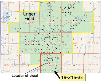
A new horizontal well will be drilled in the Unger field in Marion County, Kansas. The data gathered in the project will be used to evaluate the remaining potential of the Unger field and the use of the drilling technology in other Kansas reservoirs. The lateral will be guided along the crest of a northwest trending anticline located in the southern part of Unger Field using real-time geosteering.

Map of Unger field with study area in the south of the field.

Overview

  • The Unger Field, discovered in 1955, has produced 8.6 MBO. While 76 wells produced in 1966, only 16 are producing at an average rate of 2.2 bbls per day. Wells have variable production rate over crest of structure and wells near original oil:water contact are still producing suggesting considerable heterogeneity of the reservoir and opportunities in infill drilling and lateral to be drilled in this project.
  • The new lateral, American Energy Corporation's Slocombe-Rood #1-19 is programmed as a 2100' horizontal that will be enter the upper most portion of the Hunton Group dolomite oil reservoir that subcrops beneath a regional (Kaskaskia) unconformity.
  • Lateral will be guided along the crest of a northwest trending anticline located in the southern part of Unger Field using real-time geosteering.
  • The thickness of net pay (porous dolomite) in the Hunton ranges from 12 ft to 25 ft. The reservoir lithology consisting of karsted, fractured, and vuggy dolomite.
  • Total thickness of the dolomite interval in the vicinity of the lateral ranges from over 60 ft on the south to around 20 ft on the north. Thinning is due to progressive northward truncation along its top along the unconformity. The northwest trajectory of the lateral will follow the uppermost porous reservoir as it undergoes northward truncation. Micrologs available in adjoining wells indicate progressive subcrop of gently southward dipping internal flow units.
  • The Hunton reservoir is overlain by a thin, tight (5-10 ft) dolomitic caprock, which in turn lies beneath a ~150 ft interval of Kinderhook and Chattanooga Shale. The lower portion of the Chattanooga Shale has elevated natural gamma radiation.
  • The Hunton reservoir is underlain by a thick section of Maquoketa Shale.
  • Lateral is being drilled to contact isolated or underproduced compartments of fractured, vuggy dolomite. Hunton in area of the lateral has produced under a strong edge-water drive (water encroachment is along the edges of reservoir).
  • The tight dolomitic caprock will aid in keeping the lateral moving through the more easily drilled porous reservoir. The elevated gamma ray of the Chattanooga Shale will also help
  • Utilizing geologic data from nearby wells combined with the radial gamma ray tool, the lateral will be guided along the upper most portion of porous Hunton dolomite.

About...

The Unger field horizontal well is a RPSEA-funded project of the Kansas Geological Survey and American Energies Corp. More ...

Topics...