![]()
Prev Page--Introduction || Next Page--Assessment
Data and Analysis
Data Sources
The KDHE provided spreadsheet files of water-quality data for the stream-sampling sites. The data included the location, date of collection, and concentrations of major and selected minor inorganic constituents in the samples. The KDHE also provided recent monthly averages of chloride concentration for selected NPDES discharges to Cow Creek and the Arkansas River. Daily data for chloride concentration and weekly data for sulfate concentration for the Morton Salt NPDES site were obtained for March and July 2002.
Examination of the water-quality data revealed that some of sample records contain inconsistencies in concentrations. Selected analytical records have errors that are too large for reliance on the chloride value as correct within an uncertainty suitable for this study. The main method for data checking was based on the charge balance error that represents the difference between the sum of the cations (positively charged constituents) and sum of the anions (negatively charged species). Sample records were not used for the assessment if the charge balance error was greater than 10% and the total dissolved solids (TDS) concentration was larger than 300 mg/L, and if the error was greater than 15% and the TDS content was larger than 200 mg/L.
The KGS collected samples from the north and south sides of the Arkansas River along a profile extending from KDHE monitoring site 523 west of Hutchinson to KDHE site 283 north of Haven in March 2002. The KGS collected samples for a more detailed profile of the Arkansas River through Hutchinson, also from the north and south sides of the river, during July 2002. The river was in a low-flow condition during each sampling profile. The March sampling included Salt Creek at KDHE site 659 and the July collection included storm drains with flowing water on the north side of the Arkansas River. The KGS sampled waters from Cow Creek and its tributaries during low-flow periods in the fall of 1999, from Cow Creek in March 2002, and from Cow Creek and the diversion canals carrying parts of its flow to the Arkansas River in July 2002. The KGS analyzed the water samples it collected for selected inorganic constituents for use in identification of salinity sources. The analyses have a high level of accuracy based on the careful attention given to optimizing the instrumental analysis conditions for the samples. The KGS laboratory participates in the USGS Analytical Evaluation Program for Standard Reference Samples each year, and has consistently had high agreement of its analytical results with those published for the reference waters after different laboratories in the U.S. send their results to the USGS.
Location and time information for the Arkansas River samples are in Table 1 and for Cow Creek and its tributaries and diversion canals. Salt Creek, and the Hutchinson storm drains are in Table 4. Chemical data for the Arkansas River samples are listed in Table 2 and for the Cow Creek and other samples in Table 5. Tables 3 and 6 list selected chemical ratios used in the salinity assessment.
Table 1. Arkansas River sampling in the Hutchinson area, location information for samples collected by the KGS.
| KGS lab no. |
Project number |
Sample location | County | Site name | Sample date |
Sample time |
KDHE site no. |
Ark R mile |
Sample location description |
|---|---|---|---|---|---|---|---|---|---|
| 020038 | TMDL-31 | 23S-06W-09CCDC | Reno | Arkansas River | 3/12/02 | 11:50 | 523 | 815.95 | 4th Ave. bridge west of Hutchinson, N side of river |
| 020039 | TMDL-32 | 23S-06W-09CCCD | Reno | Arkansas River | 3/12/02 | 11:55 | 523 | 815.95 | 4th Ave. bridge west of Hutchinson, S side of river |
| 020041 | TMDL-34 | 23S-06W-24BBBA | Reno | Arkansas River | 3/12/02 | 12:30 | 812.62 | Hwy 96 bridge, Hutchinson, N side of river | |
| 020042 | TMDL-35 | 23S-06W-24BBBC | Reno | Arkansas River | 3/12/02 | 12:38 | 812.62 | Hwy 96 bridge, Hutchinson, S side of river | |
| 020043 | TMDL-36 | 23S-06W-24DCDA | Reno | Arkansas River | 3/12/02 | 13:37 | 811.51 | Carey Park railroad bridge, Hutchinson, N side of river | |
| 020044 | TMDL-37 | 23S-05W-30CADD | Reno | Arkansas River | 3/12/02 | 13:52 | 810.38 | Hwy 50-61 bridge, Hutchinson, N side of river | |
| 020045 | TMDL-38 | 23S-05W-30CDAA | Reno | Arkansas River | 3/12/02 | 14:08 | 810.38 | Hwy 50-61 bridge, Hutchinson, S side of river | |
| 020046 | TMDL-39 | 24S-05W-03CCCC | Reno | Arkansas River | 3/12/02 | 14:30 | 524 | 806.50 | Bridge on road north of Yoder, N side of river |
| 020047 | TMDL-40 | 24S-05W-10BBBB | Reno | Arkansas River | 3/12/02 | 14:37 | 524 | 806.50 | Bridge on road north of Yoder, S side of river |
| 020049 | TMDL-42 | 24S-04W-20DAAD | Reno | Arkansas River | 3/12/02 | 15:05 | 283 | 800.30 | Bridge north of Haven, N side of river |
| 020050 | TMDL-43 | 24S-04W-20DADA | Reno | Arkansas River | 3/12/02 | 15:13 | 283 | 800.30 | Bridge N of Haven, S side of river, near USGS gage |
| 020197 | TMDL-51 | 23S-06W-09CCDC | Reno | Arkansas River | 7/15/02 | 11:00 | 523 | 815.95 | Under 4th Ave. bridge, E/N side of river |
| 020199 | TMDL-53 | 23S-06W-23ABBA | Reno | Arkansas River | 7/15/02 | 13:06 | 813.15 | Railroad bridge SW of Hutchinson, N side of river | |
| 020200 | TMDL-54 | 23S-06W-23ABBA | Reno | Arkansas River | 7/15/02 | 13:05 | 813.15 | Railroad bridge SW of Hutchinson, S side of river | |
| 020202 | TMDL-56 | 23S-06W-24BBBA | Reno | Arkansas River | 7/15/02 | 13:31 | 812.62 | Hwy 96 bridge, Hutchinson, N side of river | |
| 020203 | TMDL-57 | 23S-06W-24BBBC | Reno | Arkansas River | 7/15/02 | 13:25 | 812.62 | Hwy 96 bridge, Hutchinson, S side of river | |
| 020205 | TMDL-59 | 23S-06W-24BDAB | Reno | Arkansas River | 7/15/02 | 14:00 | 812.25 | Bridge off extension of Main St., N side of river | |
| 020206 | TMDL-60 | 23S-06W-24BDBD | Reno | Arkansas River | 7/15/02 | 13:40 | 812.25 | Bridge off extension of Main St., S side of river | |
| 020207 | TMDL-61 | 23S-06W-24DBCD | Reno | Arkansas River | 7/15/02 | 15:01 | 811.84 | Carey Park upstream of drain 2, N side of river | |
| 020208 | TMDL-62 | 23S-06W-24DBCC | Reno | Arkansas River | 7/15/02 | 15:00 | 811.84 | Across river from site TMDL-61, S side of river | |
| 020210 | TMDL-64 | 23S-06W-24DCDA | Reno | Arkansas River | 7/15/02 | 15:18 | 811.51 | Railroad bridge at Carey Park, N side of river | |
| 020211 | TMDL-65 | 23S-06W-24DCDC | Reno | Arkansas River | 7/15/02 | 15:12 | 811.51 | Railroad bridge at Carey Park, S side of river | |
| 020212 | TMDL-66 | 23S-05W-30BCBC | Reno | Arkansas River | 7/15/02 | 15:47 | 810.97 | Below new Carey Park shelter, N side of river | |
| 020213 | TMDL-67 | 23S-05W-30BCCB | Reno | Arkansas River | 7/15/02 | 15:47 | 810.97 | Across river from site TMDL-66, S side of river | |
| 020214 | TMDL-68 | 23S-05W-30CADD | Reno | Arkansas River | 7/15/02 | 16:08 | 810.38 | Hwy 50-61 bridge, N side of river | |
| 020215 | TMDL-69 | 23S-05W-30CDAA | Reno | Arkansas River | 7/15/02 | 16:08 | 810.38 | Hwy 50-61 bridge, S side of river | |
| 020216 | TMDL-70 | 23S-05W-31AABB | Reno | Arkansas River | 7/15/02 | 16:35 | 809.99 | Across river from site TMDL-71, N side of river | |
| 020217 | TMDL-71 | 23S-05W-31ABAA | Reno | Arkansas River | 7/15/02 | 16:35 | 809.99 | At dry stream confluence, S side of river |
Table 2. Arkansas River sampling in the Hutchinson area, chemical data for samples collected by the KGS.
| Project number |
Sample location | Site name | Sample date |
Sample location | Lab SpC μS/cm |
Ca mg/L |
Mg mg/L |
Na mg/L |
K mg/L |
SO4 mg/L |
Cl mg/L |
Br mg/L |
I mg/L |
|---|---|---|---|---|---|---|---|---|---|---|---|---|---|
| TMDL-31 | 23S-06W-09CCDC | Arkansas River | 3/12/02 | 4th Ave. bridge, N side of river | 2480 | 108 | 25.4 | 375 | 5.6 | 182 | 542 | 0.22 | 0.0096 |
| TMDL-32 | 23S-06W-09CCCD | Arkansas River | 3/12/02 | 4th Ave. bridge, S side of river | 2480 | 111 | 25.9 | 388 | 5.4 | 182 | 542 | 0.22 | 0.0091 |
| TMDL-34 | 23S-06W-24BBBA | Arkansas River | 3/12/02 | Hwy 96 bridge, N side | 2450 | 111 | 26.4 | 380 | 5.8 | 182 | 537 | 0.26 | 0.0100 |
| TMDL-35 | 23S-06W-24BBBC | Arkansas River | 3/12/02 | Hwy 96 bridge, S side | 2690 | 111 | 30.7 | 414 | 6.8 | 187 | 622 | 0.35 | 0.0117 |
| TMDL-36 | 23S-06W-24DCDA | Arkansas River | 3/12/02 | Carey Park railroad bridge, N side | 2510 | 109 | 27.2 | 382 | 6.3 | 176 | 555 | 0.28 | 0.0110 |
| TMDL-37 | 23S-05W-30CADD | Arkansas River | 3/12/02 | Hwy 50-61 bridge, N side | 2560 | 109 | 27.6 | 390 | 6.1 | 179 | 567 | 0.28 | 0.0109 |
| TMDL-38 | 23S-05W-30CDAA | Arkansas River | 3/12/02 | Hwy 50-61 bridge, S side | 2610 | 106 | 26.7 | 410 | 7.1 | 172 | 585 | 0.28 | 0.0151 |
| TMDL-39 | 24S-05W-03CCCC | Arkansas River | 3/12/02 | Bridge N of Yoder, N side | 2510 | 104 | 25.7 | 376 | 7.2 | 172 | 539 | 0.25 | 0.0140 |
| TMDL-40 | 24S-05W-10BBBB | Arkansas River | 3/12/02 | Bridge N of Yoder, S side | 2530 | 104 | 25.7 | 386 | 6.1 | 169 | 550 | 0.27 | 0.0119 |
| TMDL-42 | 24S-04W-20DAAD | Arkansas River | 3/12/02 | Bridge N of Haven, N side | 2460 | 110 | 26.4 | 371 | 6.8 | 173 | 536 | 0.31 | 0.0122 |
| TMDL-43 | 24S-04W-20DADA | Arkansas River | 3/12/02 | Bridge N of Haven, S side | 2500 | 109 | 26.7 | 380 | 6.9 | 171 | 552 | 0.32 | 0.0122 |
| TMDL-51 | 23S-06W-09CCDC | Arkansas River | 7/15/02 | 4th Ave. bridge, N side of river | 3220 | 173 | 803 | 0.25 | 0.0086 | ||||
| TMDL-53 | 23S-06W-23ABBA | Arkansas River | 7/15/02 | Railroad bridge, N side | 2930 | 162 | 728 | 0.25 | 0.0096 | ||||
| TMDL-54 | 23S-06W-23ABBA | Arkansas River | 7/15/02 | Railroad bridge, S side | 3700 | 202 | 932 | 0.53 | 0.0146 | ||||
| TMDL-56 | 23S-06W-24BBBA | Arkansas River | 7/15/02 | Hwy 96 bridge, N side | 3000 | 168 | 765 | 0.26 | 0.0090 | ||||
| TMDL-57 | 23S-06W-24BBBC | Arkansas River | 7/15/02 | Hwy 96 bridge, S side | 3300 | 183 | 852 | 0.32 | 0.0118 | ||||
| TMDL-59 | 23S-06W-24BDAB | Arkansas River | 7/15/02 | Bridge off Main St., N side | 3040 | 171 | 769 | 0.27 | 0.0106 | ||||
| TMDL-60 | 23S-06W-24BDBD | Arkansas River | 7/15/02 | Bridge off Main St., S side | 3130 | 176 | 818 | 0.30 | 0.0125 | ||||
| TMDL-61 | 23S-06W-24DBCD | Arkansas River | 7/15/02 | Carey Park near drain 2, N side | 3100 | 170 | 790 | 0.28 | 0.0117 | ||||
| TMDL-62 | 23S-06W-24DBCC | Arkansas River | 7/15/02 | Across from site TMDL-61, S side | 3100 | 167 | 794 | 0.29 | 0.0131 | ||||
| TMDL-64 | 23S-06W-24DCDA | Arkansas River | 7/15/02 | Carey Park railroad bridge, N side | 3100 | 167 | 779 | 0.29 | 0.0123 | ||||
| TMDL-65 | 23S-06W-24DCDC | Arkansas River | 7/15/02 | Carey Park railroad bridge, S side | 3040 | 168 | 776 | 0.28 | 0.0118 | ||||
| TMDL-66 | 23S-05W-30BCBC | Arkansas River | 7/15/02 | Carey Park shelter, N side | 3100 | 165 | 783 | 0.29 | 0.0118 | ||||
| TMDL-67 | 23S-05W-30BCCB | Arkansas River | 7/15/02 | Across from site TMDL-66, S side | 3100 | 175 | 805 | 0.29 | 0.0120 | ||||
| TMDL-68 | 23S-05W-30CADD | Arkansas River | 7/15/02 | Hwy 50-61 bridge, N side | 3140 | 175 | 812 | 0.29 | 0.0125 | ||||
| TMDL-69 | 23S-05W-30CDAA | Arkansas River | 7/15/02 | Hwy 50-61 bridge, S side | 3160 | 142 | 773 | 0.24 | 0.0207 | ||||
| TMDL-70 | 23S-05W-31AABB | Arkansas River | 7/15/02 | Across from site TMDL-71, N side | 3160 | 176 | 825 | 0.29 | 0.0119 | ||||
| TMDL-71 | 23S-05W-31ABAA | Arkansas River | 7/15/02 | Dry stream confluence, S side | 3160 | 169 | 804 | 0.27 | 0.0133 |
Table 3. Arkansas River sampling in the Hutchinson area, chemical ratios for samples collected by the KGS.
| Project number |
Sample location | Site name | Sample date |
Sample location | Cl mg/L |
(Ca+Mg)/Na mass ratio |
Na/Cl mass ratio |
SO4/Cl mass ratio |
Br/Cl X 10000 |
I/Cl X 1000000 |
|---|---|---|---|---|---|---|---|---|---|---|
| TMDL-31 | 23S-06W-09CCDC | Arkansas River | 3/12/02 | 4th Ave. bridge, N side of river | 542 | 0.356 | 0.692 | 0.336 | 4.1 | 17.7 |
| TMDL-32 | 23S-06W-09CCCD | Arkansas River | 3/12/02 | 4th Ave. bridge, S side of river | 542 | 0.353 | 0.716 | 0.336 | 4.1 | 16.8 |
| TMDL-34 | 23S-06W-24BBBA | Arkansas River | 3/12/02 | Hwy 96 bridge, N side | 537 | 0.362 | 0.708 | 0.339 | 4.9 | 18.6 |
| TMDL-35 | 23S-06W-24BBBC | Arkansas River | 3/12/02 | Hwy 96 bridge, S side | 622 | 0.342 | 0.666 | 0.301 | 5.7 | 18.8 |
| TMDL-36 | 23S-06W-24DCDA | Arkansas River | 3/12/02 | Carey Park railroad bridge, N side | 555 | 0.357 | 0.688 | 0.317 | 5.0 | 19.8 |
| TMDL-37 | 23S-05W-30CADD | Arkansas River | 3/12/02 | Hwy 50-61 bridge, N side | 567 | 0.350 | 0.688 | 0.316 | 5.0 | 19.2 |
| TMDL-38 | 23S-05W-30CDAA | Arkansas River | 3/12/02 | Hwy 50-61 bridge, S side | 585 | 0.324 | 0.701 | 0.294 | 4.7 | 25.8 |
| TMDL-39 | 24S-05W-03CCCC | Arkansas River | 3/12/02 | Bridge N of Yoder, N side | 539 | 0.345 | 0.698 | 0.319 | 4.7 | 26.0 |
| TMDL-40 | 24S-05W-10BBBB | Arkansas River | 3/12/02 | Bridge N of Yoder, S side | 550 | 0.336 | 0.702 | 0.307 | 4.8 | 21.6 |
| TMDL-42 | 24S-04W-20DAAD | Arkansas River | 3/12/02 | Bridge N of Haven, N side | 536 | 0.368 | 0.692 | 0.323 | 5.8 | 22.8 |
| TMDL-43 | 24S-04W-20DADA | Arkansas River | 3/12/02 | Bridge N of Haven, S side | 552 | 0.357 | 0.688 | 0.310 | 5.8 | 22.1 |
| TMDL-51 | 23S-06W-09CCDC | Arkansas River | 7/15/02 | 4th Ave. bridge, N side of river | 803 | 0.215 | 3.2 | 10.7 | ||
| TMDL-53 | 23S-06W-23ABBA | Arkansas River | 7/15/02 | Railroad bridge, N side | 728 | 0.223 | 3.5 | 13.2 | ||
| TMDL-54 | 23S-06W-23ABBA | Arkansas River | 7/15/02 | Railroad bridge, S side | 932 | 0.217 | 5.7 | 15.7 | ||
| TMDL-56 | 23S-06W-24BBBA | Arkansas River | 7/15/02 | Hwy 96 bridge, N side | 765 | 0.220 | 3.3 | 11.8 | ||
| TMDL-57 | 23S-06W-24BBBC | Arkansas River | 7/15/02 | Hwy 96 bridge, S side | 852 | 0.215 | 3.7 | 13.8 | ||
| TMDL-59 | 23S-06W-24BDAB | Arkansas River | 7/15/02 | Bridge off Main St., N side | 769 | 0.222 | 3.5 | 13.8 | ||
| TMDL-60 | 23S-06W-24BDBD | Arkansas River | 7/15/02 | Bridge off Main St., S side | 818 | 0.215 | 3.7 | 15.3 | ||
| TMDL-61 | 23S-06W-24DBCD | Arkansas River | 7/15/02 | Carey Park near drain 2, N side | 790 | 0.215 | 3.5 | 14.8 | ||
| TMDL-62 | 23S-06W-24DBCC | Arkansas River | 7/15/02 | Across from site TMDL-61, S side | 794 | 0.210 | 3.7 | 16.5 | ||
| TMDL-64 | 23S-06W-24DCDA | Arkansas River | 7/15/02 | Carey Park railroad bridge, N side | 779 | 0.214 | 3.7 | 15.8 | ||
| TMDL-65 | 23S-06W-24DCDC | Arkansas River | 7/15/02 | Carey Park railroad bridge, S side | 776 | 0.216 | 3.7 | 15.2 | ||
| TMDL-66 | 23S-05W-30BCBC | Arkansas River | 7/15/02 | Carey Park shelter, N side | 783 | 0.211 | 3.7 | 15.1 | ||
| TMDL-67 | 23S-05W-30BCCB | Arkansas River | 7/15/02 | Across from site TMDL-66, S side | 805 | 0.217 | 3.5 | 14.9 | ||
| TMDL-68 | 23S-05W-30CADD | Arkansas River | 7/15/02 | Hwy 50-61 bridge, N side | 812 | 0.216 | 3.6 | 15.4 | ||
| TMDL-69 | 23S-05W-30CDAA | Arkansas River | 7/15/02 | Hwy 50-61 bridge, S side | 773 | 0.184 | 3.1 | 26.8 | ||
| TMDL-70 | 23S-05W-31AABB | Arkansas River | 7/15/02 | Across from site TMDL-71, N side | 825 | 0.213 | 3.5 | 14.4 | ||
| TMDL-71 | 23S-05W-31ABAA | Arkansas River | 7/15/02 | Dry stream confluence, S side | 804 | 0.210 | 3.4 | 16.5 |
Table 4. Cow Creek, Salt Creek, and storm drain sampling in the Hutchinson area, location information for samples collected by the KGS.
| KGS lab no. |
Project number |
Sample location | County | Site name | Sample date |
Sample time |
KDHE site no. |
Ark R mile at confluence |
Sample location description |
|---|---|---|---|---|---|---|---|---|---|
| 990294 | TMDL-1 | 19S-12W-11BBAB | Barton | Little Cheyenne Creek | 10/7/99 | 9:20 | End of outlet canal, 2 miles SE of Cheyenne Bottoms pools |
||
| 990295 | TMDL-2 | 18S-11W-35DAAA | Barton | Little Cheyenne Creek | 10/7/99 | 9:45 | 1.5 miles upstream of Cow Creek confluence | ||
| 990296 | TMDL-3 | 18S-11W-26AAAD | Rice | Cow Creek | 10/7/99 | 10:00 | 2 miles upstream of Little Cheyenne Cr confluence | ||
| 990297 | TMDL-4 | 19S-10W-1AAAD | Rice | Cow Creek | 10/7/99 | 10:35 | 1 mile upstream of Plum Creek confluence | ||
| 990298 | TMDL-5 | 18S-9W-30CCDD | Rice | Plum Creek | 10/7/99 | 10:50 | 1 mile upstream of Cow Creek confluence | ||
| 990299 | TMDL-6 | 20S-8W-16ADAA | Rice | Little Cow Creek | 10/7/99 | 11:40 | 0.7 mile upstream of Cow Cr confluence, 0.3 mile downstream of Lyons wastewater discharge |
||
| 990300 | TMDL-7 | 20S-8W-16DDAD | Rice | Cow Creek | 10/7/99 | 11:50 | 0.8 mile upstream of Little Cow Creek confluence | ||
| 990301 | TMDL-8 | 20S-7W-30BBAB | Rice | Cow Creek | 10/7/99 | 12:10 | 3 miles downstream of Owl Creek confluence | ||
| 990320 | TMDL-13 | 20S-9W-3AAAB | Rice | Spring Creek | 11/19/99 | 11:40 | Several hundred ft upstream of Cow Cr confluence | ||
| 990321 | TMDL-14 | 19S-9W-34DDDD | Rice | Cow Creek | 11/19/99 | 11:50 | A few hundred feet upstream of Spring Creek | ||
| 990322 | TMDL-15 | 20S-9W-2BBBC | Rice | Cow Creek | 11/19/99 | 12:00 | 100 yds downstream of Spring Creek confluence | ||
| 990323 | TMDL-16 | 20S-8W-16ADAA | Rice | Little Cow Creek | 11/19/99 | 13:20 | 0.7 mile upstream of Cow Cr confluence, 0.3 mile downstream of Lyons wastewater discharge |
||
| 990324 | TMDL-17 | 20S-8W-10DDCD | Rice | Owl Creek | 11/19/99 | 13:55 | 1 mile upstream of Cow Creek confluence | ||
| 020048 | TMDL-41 | 24S-05W-02CCCB | Reno | Cow Creek | 3/12/02 | 14:49 | 287 | 804.87 | 1.2 mile east of Arkansas R Yoder bridge |
| 020198 | TMDL-52 | 23S-06W-15ABBA | Reno | Cow Cr diversion canal | 7/15/02 | 11:15 | 814.24 | Under 4th Ave. bridge, W side of flow | |
| 020201 | TMDL-55 | 23S-06W-14DDCD | Reno | Cow Cr - Harsha Canal | 7/15/02 | 13:20 | 812.75 | 50 ft above outlet to river, N side of culvert | |
| 020218 | TMDL-72 | 23S-05W-29ABBB | Reno | Cow Creek | 7/15/02 | 17:14 | Under Hwy 50 bridge, E side of creek | ||
| 020040 | TMDL-33 | 23S-06W-16BCCC | Reno | Salt Creek | 3/12/02 | 12:05 | 659 | 814.06 | 0.6 mile SSW of Ark R 4th Ave. bridge |
| 020204 | TMDL-58 | 23S-06W-24BABC | Reno | Hutchinson drain 1 | 7/15/02 | 13:45 | 812.43 | Storm drain 200 yds N of river | |
| 020209 | TMDL-63 | 23S-06W-24DBCA | Reno | Hutchinson drain 2 | 7/15/02 | 15:04 | 811.84 | Storm drain at Carey Park 15 ft upstream of river |
Table 5. Cow Creek, Salt Creek, and storm drain sampling in the Hutchinson area, chemical data for samples collected by the KGS.
| Project number |
Sample location | Site name | Sample date |
Sample location | Lab SpC μS/cm |
Ca mg/L |
Mg mg/L |
Na mg/L |
K mg/L |
SO4 mg/L |
Cl mg/L |
Br mg/L |
I mg/L |
|---|---|---|---|---|---|---|---|---|---|---|---|---|---|
| TMDL-1 | 19S-12W-11BBAB | Little Cheyenne Creek | 10/7/99 | End of Cheyenne Bottoms outlet | 8746 | 497 | 2573 | 2.86 | 0.102 | ||||
| TMDL-2 | 18S-11W-35DAAA | Little Cheyenne Creek | 10/7/99 | Upstream of Cow Cr confluence | 2830 | 196 | 678 | 1.08 | 0.021 | ||||
| TMDL-3 | 18S-11W-26AAAD | Cow Creek | 10/7/99 | Upstream of L Cheyenne Cr confl. | 1495 | 51.3 | 261 | 0.25 | 0.017 | ||||
| TMDL-4 | 19S-10W-1AAAD | Cow Creek | 10/7/99 | Upstream of Plum Creek confl. | 2480 | 138 | 536 | 0.75 | 0.019 | ||||
| TMDL-5 | 18S-9W-30CCDD | Plum Creek | 10/7/99 | Upstream of Cow Creek confl. | 1305 | 45.9 | 215 | 0.18 | 0.014 | ||||
| TMDL-6 | 20S-8W-16ADAA | Little Cow Creek | 10/7/99 | Upstream of Cow Cr confluence, downstream of Lyons wastewtr. |
2150 | 95.8 | 433 | 0.06 | 0.003 | ||||
| TMDL-7 | 20S-8W-16DDAD | Cow Creek | 10/7/99 | Upstream of Little Cow Cr confl. | 1975 | 96.2 | 411 | 0.72 | 0.015 | ||||
| TMDL-8 | 20S-7W-30BBAB | Cow Creek | 10/7/99 | Downstream of Owl Cr confl. | 1710 | 92.4 | 335 | 0.52 | 0.014 | ||||
| TMDL-13 | 20S-9W-3AAAB | Spring Creek | 11/19/99 | Upstream of Cow Cr confluence | 2210 | 70.4 | 530 | 1.12 | 0.022 | ||||
| TMDL-14 | 19S-9W-34DDDD | Cow Creek | 11/19/99 | Upstream of Spring Creek confl. | 2480 | 114 | 554 | 0.80 | 0.028 | ||||
| TMDL-15 | 20S-9W-2BBBC | Cow Creek | 11/19/99 | Downstream of Spring Cr confl. | 2430 | 107 | 549 | 0.91 | 0.027 | ||||
| TMDL-16 | 20S-8W-16ADAA | Little Cow Creek | 11/19/99 | Upstream of Cow Cr confluence, downstream of Lyons wastewtr. |
2150 | 94.6 | 434 | 0.10 | 0.003 | ||||
| TMDL-17 | 20S-8W-10DDCD | Owl Creek | 11/19/99 | Upstream of Cow Cr confluence | 545 | 26.0 | 101 | 0.20 | 0.004 | ||||
| TMDL-41 | 24S-05W-02CCCB | Cow Creek | 3/12/02 | East of Arkansas R Yoder bridge | 1970 | 120 | 23.7 | 258 | 6.4 | 159 | 374 | 0.40 | 0.014 |
| TMDL-52 | 23S-06W-15ABBA | Cow Cr diversion canal | 7/15/02 | 4th Ave. bridge, W side of flow | 1245 | 86.3 | 223 | 0.35 | 0.013 | ||||
| TMDL-55 | 23S-06W-14DDCD | Cow Cr - Harsha Canal | 7/15/02 | Above outlet to river | 995 | 130 | 141 | 0.10 | 0.009 | ||||
| TMDL-72 | 23S-05W-29ABBB | Cow Creek | 7/15/02 | Under Hwy 50 bridge | 1850 | 165 | 374 | 0.34 | 0.012 | ||||
| TMDL-33 | 23S-06W-16BCCC | Salt Creek | 3/12/02 | SSW of Ark R 4th Ave. bridge | 4405 | 92.8 | 22.1 | 804 | 4.4 | 145 | 1181 | 0.24 | 0.008 |
| TMDL-58 | 23S-06W-24BABC | Hutchinson drain 1 | 7/15/02 | Storm drain 200 yds N of river | 1860 | 264 | 301 | 0.22 | 0.013 | ||||
| TMDL-63 | 23S-06W-24DBCA | Hutchinson drain 2 | 7/15/02 | Storm drain at Carey Park | 1950 | 160 | 407 | 0.19 | 0.012 |
Table 6. Cow Creek, Salt Creek, and storm drain sampling in the Hutchinson area, chemical ratios for samples collected by the KGS.
| Project number |
Sample location | Site name | Sample date |
Sample location | Cl mg/L |
(Ca+Mg)/Na mass ratio |
Na/Cl mass ratio |
SOi/Cl mass ratio |
Br/Cl x10000 |
I/Cl x1000000 |
|---|---|---|---|---|---|---|---|---|---|---|
| TMDL-1 | 19S-12W-11BBAB | Little Cheyenne Creek | 10/7/99 | End of Cheyenne Bottoms outlet | 2573 | 0.193 | 11.1 | 39.6 | ||
| TMDL-2 | 18S-11W-35DAAA | Little Cheyenne Creek | 10/7/99 | Upstream of Cow Cr confluence | 678 | 0.289 | 15.9 | 30.5 | ||
| TMDL-3 | 18S-11W-26AAAD | Cow Creek | 10/7/99 | Upstream of L Cheyenne Cr confl. | 261 | 0.197 | 9.4 | 63.6 | ||
| TMDL-4 | 19S-10W-1AAAD | Cow Creek | 10/7/99 | Upstream of Plum Creek confl. | 536 | 0.257 | 14.0 | 35.4 | ||
| TMDL-5 | 18S-9W-30CCDD | Plum Creek | 10/7/99 | Upstream of Cow Creek confl. | 215 | 0.213 | 8.4 | 64.2 | ||
| TMDL-6 | 20S-8W-16ADAA | Little Cow Creek | 10/7/99 | Upstream of Cow Cr confluence, downstream of Lyons wastewtr. |
433 | 0.221 | 1.4 | 5.8 | ||
| TMDL-7 | 20S-8W-16DDAD | Cow Creek | 10/7/99 | Upstream of Little Cow Cr confl. | 411 | 0.234 | 17.5 | 37.2 | ||
| TMDL-8 | 20S-7W-30BBAB | Cow Creek | 10/7/99 | Downstream of Owl Cr confl. | 335 | 0.276 | 15.4 | 40.9 | ||
| TMDL-13 | 20S-9W-3AAAB | Spring Creek | 11/19/99 | Upstream of Cow Cr confluence | 530 | 0.133 | 21.1 | 41.5 | ||
| TMDL-14 | 19S-9W-34DDDD | Cow Creek | 11/19/99 | Upstream of Spring Creek confl. | 554 | 0.206 | 14.5 | 50.4 | ||
| TMDL-15 | 20S-9W-2BBBC | Cow Creek | 11/19/99 | Downstream of Spring Cr confl. | 549 | 0.195 | 16.6 | 49.5 | ||
| TMDL-16 | 20S-8W-16ADAA | Little Cow Creek | 11/19/99 | Upstream of Cow Cr confluence, downstream of Lyons wastewtr. |
434 | 0.218 | 2.3 | 7.4 | ||
| TMDL-17 | 20S-8W-10DDCD | Owl Creek | 11/19/99 | Upstream of Cow Cr confluence | 101 | 0.257 | 20.0 | 36.6 | ||
| TMDL-41 | 24S-05W-02CCCB | Cow Creek | 3/12/02 | East of Arkansas R Yoder bridge | 374 | 0.557 | 0.690 | 0.425 | 10.7 | 38.2 |
| TMDL-52 | 23S-06W-15ABBA | Cow Cr diversion canal | 7/15/02 | 4th Ave. bridge, W side of flow | 223 | 0.387 | 15.5 | 56.5 | ||
| TMDL-55 | 23S-06W-14DDCD | Cow Cr - Harsha Canal | 7/15/02 | Above outlet to river | 141 | 0.922 | 7.1 | 66.0 | ||
| TMDL-72 | 23S-05W-29ABBB | Cow Creek | 7/15/02 | Under Hwy 50 bridge | 374 | 0.441 | 9.0 | 32.9 | ||
| TMDL-33 | 23S-06W-16BCCC | Salt Creek | 3/12/02 | SSW of Ark R 4th Ave. bridge | 1181 | 0.143 | 0.681 | 0.123 | 2.0 | 6.6 |
| TMDL-58 | 23S-06W-24BABC | Hutchinson drain 1 | 7/15/02 | Storm drain 200 yds N of river | 301 | 0.877 | 7.4 | 43.9 | ||
| TMDL-63 | 23S-06W-24DBCA | Hutchinson drain 2 | 7/15/02 | Storm drain at Carey Park | 407 | 0.393 | 4.7 | 28.3 |
Characterization of Chloride and Flow Relationships
Gar-Peace Subbasin
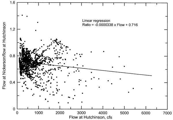
Figures 1 and 2 display the variation in chloride concentration with flow of the Arkansas River west of Hutchinson (KDHE water-quality site 523) and north of Yoder (KDHE site 524). The chloride values represent the period 5/14/90-4/15/02 for the Arkansas River west of Hutchinson (KDHE water-quality site 523) and 3/19/90-4/15/02 for the Arkansas River north of Yoder (KDHE site 524). The flow values used for KDHE monitoring site 523 are a combination of the flow record at the U.S. Geological Survey (USGS) gaging station on the river at Nickerson and adjusted flow values from the USGS station north of Haven. The flow data for KDHE site 524 are from the USGS gage on the Arkansas River north of Haven. The flow values for the Nickerson gaging station should be a good representation of the flow at KDHE site 523 because the USGS gage is about 10 miles upstream of site 523 and no significant tributaries enter the Arkansas River between the flow gage and site 523. The USGS gage at Nickerson began recording flow in July 1997; the flow values available for this gage were used for the dates of water sampling at site 523 that occurred during this time. The flow values for water samples collected before the gage at Nickerson began operation were obtained by multiplying a function times the flow north of Haven. The function is the linear regression of the ratio of the Arkansas River daily mean flows recorded at Nickerson and north of Haven for the same dates (Figure 3) for the period of July 1997 through September 2001 (corrected USGS flow data). Although the two gaging stations are separated by 25.5 river miles that represent about one day of flow travel time, the use of corresponding flow dates for the ratio values gave a higher correlation coefficient and appeared to fit slightly better at moderate to high flows than use of a one-day lag time. However, the scatter for the ratio is substantial as indicated in Figure 3. The better correlation for the corresponding day ratio than the one-day lag suggests that the similar times for rise in flow due to area precipitation events exerts a greater control on the overall ratios than the one-day transmission of flow from one gage to another.
Figure 1. Variation in chloride concentration with flow in the Arkansas River west of Hutchinson (KDHE water-quality monitoring site 523).
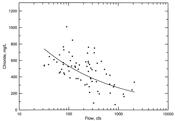
Figure 2. Variation in chloride concentration with flow in the Arkansas River southeast of Hutchinson (KDHE water-quality monitoring site 524 north of Yoder).
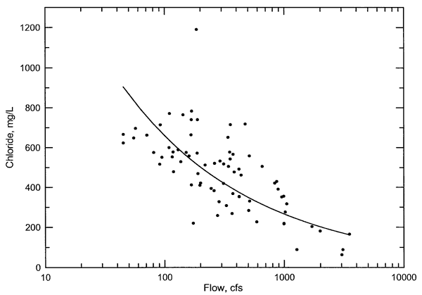
Figure 3. Ratio of Arkansas River flow near Nickerson to the flow southeast of Hutchinson versus flow southeast of Hutchinson. The flow values are for the USGS gaging stations at these locations.
The chloride concentration at KDHE sites 523 and 524 generally decreases with increasing flow of the Arkansas River (Figures 1 and 2) as typical for stream chemistry predominantly reflecting the mixture of the two end members, mineralized baseflow and dilute overland flow from heavy rain. However, there is an appreciable amount of scatter in the data about the best-fit curve for each of the figures. The fitted curve is a power function that is more appropriate for the dissolved constituent-flow relationship than linear, polynomial, or exponential functions. The main cause of the scatter for both locations is the presence or absence of flow in the Arkansas River in the Gar-Peace Subbasin derived from the upper Arkansas River in eastern Colorado. Other causes of scatter include the relative amounts of different tributary inflows and the timing of the sample collection relative to the rise and fall of flow peaks caused by rainfall events. The estimated flow values used for part of the sampling period for the Arkansas River at site 523 also contributes to the point scatter in Figure 1.
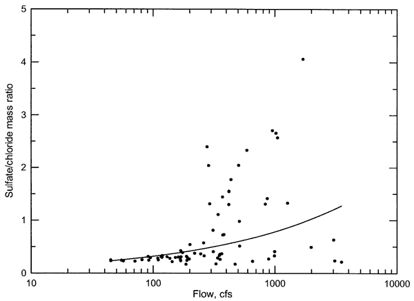
Plots of the sulfate/chloride ratio versus flow for the Arkansas River west and southeast of Hutchinson indicate the two different types of waters that occur in varying mixture percentages in the river (Figures 4 and 5). The Arkansas River crossing the Colorado-Kansas state line is one of the most saline rivers in the U.S. The water has a high sulfate content; the sulfate/chloride mass ratio averages about 15. The chemistry of the water does not change substantially during flow through southwest Kansas. In contrast, saline ground water and tributaries in south-central Kansas (such as Rattlesnake, Peace, and Salt creeks) entering the Arkansas River have a sulfate/chloride ratio typically less than 0.3 because the saltwater source in Permian strata has a sulfate/chloride ratio usually less than 0.2. The difference of over a factor of 50 in the sulfate/chloride ratios of the different water types results in substantial variations in the water chemistry of the Arkansas River in the Gar-Peace Subbasin depending on the amount of upper Arkansas River flow that reaches the subbasin area. Substantial flow from the upper Arkansas River present in the Gar-Peace Subbasin substantially raises the sulfate concentration and dilutes the chloride content of the mixture with the saline Permian water. The high sulfate/chloride ratios above the best-fit power curves in Figures 4 and 5 reflect the input of the upper Arkansas River water. When little or no flow from the upper Arkansas River reaches the Gar-Peace subbasin, the sulfate/chloride ratio of the river in the Hutchinson area is low, both at low and high flows. The nearly constant sulfate/chloride ratio for the points in Figures 4 and 5 under the best-fit curve and extending to low flows represent the predominant influence of Permian salt input to the Arkansas River in the Gar-Peace Subbasin.
Figure 4. Variation in sulfate/chloride mass ratio with flow in the Arkansas River west of Hutchinson (KDHE water-quality monitoring site 523).
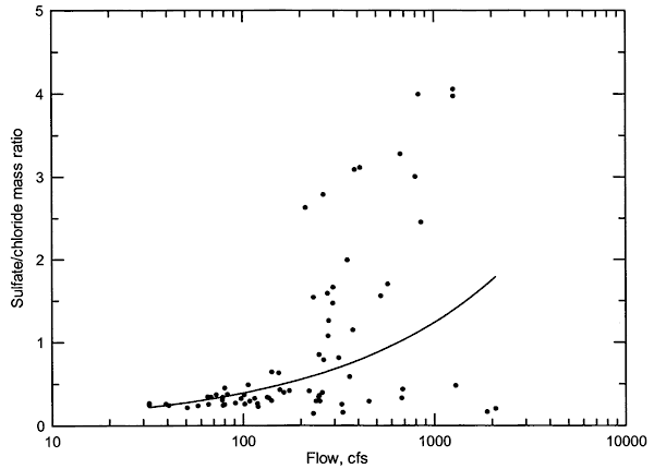
Figure 5. Variation in sulfate/chloride mass ratio with flow in the Arkansas River southeast of Hutchinson (KDHE water-quality monitoring site 524 north of Yoder).
Chloride loads increase substantially with flow in the Arkansas River in the Hutchinson area (Figures 6 and 7). The best-fit lines in the figures are based on power functions. In general, the river waters with high sulfate/chloride ratios tend to have lower chloride loads than those with low sulfate/chloride ratios, given similar flow. However, the separation into different classes of high and low chloride loads based on the percentage of upper Arkansas River water is not as consistent as for the sulfate/chloride ratio graphs due to the influence of the other factors impacting the flow and chemistry stated as responsible for point scatter in the chloride versus flow graphs (Figures 1 and 2).
Figure 6. Variation in chloride load with flow in the Arkansas River west of Hutchinson (KDHE water-quality monitoring site 523).
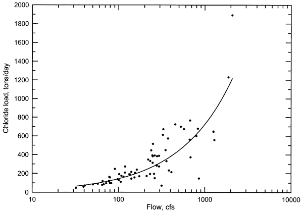
Figure 7. Variation in chloride load with flow in the Arkansas River southeast of Hutchinson (KDHE water-quality monitoring site 524 north of Yoder).
Cow Creek Subbasin
The USGS operates only one gaging station on Cow Creek for which it determines streamflow (the station near Lyons). The USGS operates a gage on Cow Creek to the southeast of Hutchinson in cooperation with the City of Hutchinson for which it records gage height, but does not compute the discharge; the gage is located north of Willowbrook and east of Nickerson. Figure 8 shows the variation in chloride concentration (KDHE water-quality site 657) with flow of Cow Creek two miles south of Lyons. The chloride values represent the period 1/13/92-6/17/02. The USGS gaging station near Lyons is located approximately 0.5-mile linear distance to the east of KDHE site 657. The gage is downstream of the KDHE site and is just downstream of the confluence of Little Cow Creek. The flow values are expected to be somewhat greater than the discharge at KDHE site 657 because the gaged drainage basin includes the Little Cow Creek watershed. The discharge from the municipal wastewater treatment plant (MWTP) of Lyons enters Little Cow Creek about one mile upstream of the confluence of Little Cow Creek with Cow Creek.
Figure 8. Variation in chloride concentration with flow in Cow Creek south of Lyons (KDHE water-quality monitoring site 657).
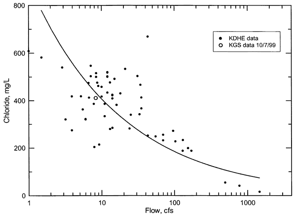
The chloride concentration at KDHE site 657 near Lyons generally decreases with increasing flow of the Arkansas River (Figure 8). The fitted curve is a power function as was used for Figures 1 and 2. Part of the appreciable amount of scatter in the data about the best-fit curve is expected to be from non-coincident flow patterns in the drainage area providing flow at KDHE site 657 and the Little Cow Creek watershed. A portion of the scatter is probably due to variations in the chloride concentration from Little Cow Creek flows that were not coincident with Cow Creek flow at site 657. Other causes of scatter include the relative amounts of different tributary inflows upstream of site 657 and the timing of the sample collection relative to the rise and fall of flow peaks caused by rainfall events.
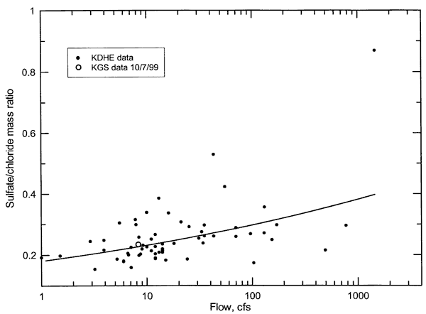
The sulfate/chloride ratio tends to increase with flow for Cow Creek south of Lyons (Figure 9). The scatter in the ratio about the best-fit power curve tends to increase with increasing flow. This suggests that either the major constituent composition of Cheyenne Bottoms discharge during dry periods, ground-water discharge within the watershed, and the input from the Lyons MWTP are similar, or the relative flow contributions of these flow components remains similar during low flows. Alternatively, both explanations could be valid. The data in Table 6 do not indicate a substantial range in the sulfate/chloride ratio for different locations in the Cow Creek watershed. The sulfate/chloride ratios for the samples in Table 6 are in the same range as for the KDHE low-flow data in Figure 9. Further discussion of low-flow chemistry is included in the section on assessment of chloride sources below. The sulfate/chloride ratio range for high flows in Cow Creek is generally similar to the ratio range for higher flows of the Arkansas River west of Hutchinson that do not include upper Arkansas River flows.
Figure 9. Variation in sulfate/chloride mass ratio with flow in Cow Creek south of Lyons (KDHE water-quality monitoring site 657).
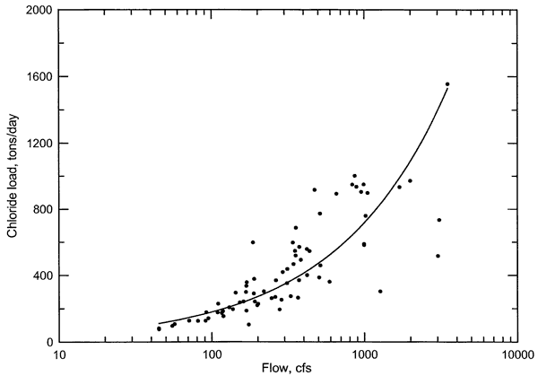
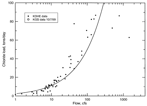
Chloride loads increase greatly with flow in Cow Creek near Lyons (Figure 10). The relationship between chloride load and flow fits a power-curve function well, especially if the three points representing the highest streamflows on Figure 10 were not included. However, these three points could suggest that the rate of increase in chloride load with increasing flow decreases at high flows where the dilution of land-surface, surface-water body, and shallow subsurface chloride loads begins to balance the increase in loads due to increase in water volume.
Figure 10. Variation in chloride load with flow in Cow Creek south of Lyons (KDHE water-quality monitoring site 657).
Prev Page--Introduction || Next Page--Assessment
Kansas Geological Survey, Geohydrology
Placed on web Feb. 3, 2006.
Comments to webadmin@kgs.ku.edu
The URL for this page is http://www.kgs.ku.edu/Hydro/Publications/2004/OFR04_05/03_data.html