![]()
Prev Page--Data and Analysis || Next Page--References
Data and Analysis, continued
Assessment of Chloride Sources
Gar-Peace Subbasin
Chloride profiles along the Arkansas River
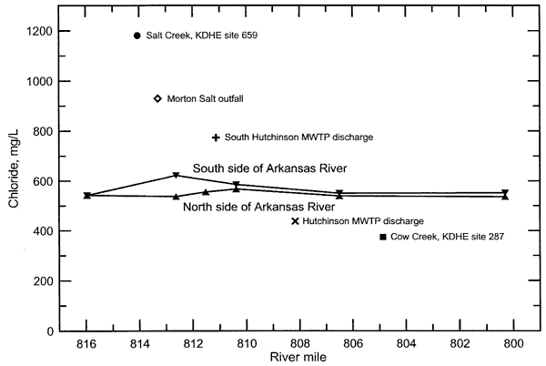
There are several different tributaries and waste effluent flows that affect the chloride concentration and load of the Arkansas River in the Hutchinson area. The chloride concentration profile along the Arkansas River for low flow in the late winter (March 12) 2002 from west of Hutchinson to north of Haven based on data in Tables 1 and 2 is shown in Figure 11. The water in the Arkansas River at the most western location in the profile (KDHE site 523) had the same chloride concentration on the north and south sides of the river. The chloride concentration on the south side of the Arkansas River at the Highway 96 bridge at the southwestern side of Hutchinson was significantly greater than that at the north side of the river. The chloride content on the south side of the river increased from that at KDHE site 523 but was essentially the same (within analytical error) on the north side of the bridge as at KDHE site 523. The profile downstream of the Highway 96 bridge to the bridge north of Haven indicated that the chloride content of the south side of the river was only slightly greater than that of the north side of the river. The chloride concentrations of Salt Creek and the Morton Salt outfall on the same date were both substantially greater than that chloride content of the Arkansas River west of Hutchinson. Although the Cow Creek diversion canal that routes a substantial amount of Cow Creek flow to the Arkansas River southwest of Hutchinson was not sampled during the profile, the chloride concentration is expected to be less than 400 mg/L based on KDHE data for Cow Creek near Willowbrook (site 522). The higher chloride content of Salt Creek and the Morton Salt outfall that enter the south side of the Arkansas River and the lower chloride expected for the Cow Creek diversion canal are the most probable reasons for the higher chloride on the south side than the north side of the Arkansas River at the Highway 96 bridge.
Figure 11. Profile of chloride concentration along the Arkansas River in the Hutchinson area for March 12, 2002.
The profile along the Arkansas River during the summer 2002 was designed to help explain observations of the winter profile by providing more detail through Hutchinson (Figure 12). The general levels of chloride in the river water were greater in the summer than in the winter profile because the flow was lower during the summer. The provisional daily mean flow for the Arkansas River near Nickerson was 73 cfs on March 12, 2002, and 62 cfs on July 15, 2002. The chloride content was again higher on the south side than on the north side of the river at the Highway 96 bridge. The chloride difference between the south and north sides of the river was even greater upstream of the Highway 96 bridge. There was substantial flow in the Cow Creek diversion canal under the 4th Avenue bridge where a water sample was collected. The relatively low chloride concentration of the Cow Creek diversion appears to be the probable cause for the small decrease in the chloride concentration of the north side of the river between KDHE site 523 and the railroad bridge. The chloride content of Salt Creek and the Morton Salt outfall appear to be the cause of the increase in chloride content on the south side of the river downstream of their entrance. The average flow of the Morton Salt outfall was 9.3 cfs in March and 8.0 cfs in July 2002, indicating that the volumes were great enough to affect the chemistry of the south portion of the low Arkansas River flows during these periods. Salt Creek at KDHE site 659 was not sampled during July 15; the chloride value of 1,400 mg/L on Figure 12 was estimated based on an examination of KDHE data for the site and the drier conditions in July than the March 12 sampling. The flow of Salt Creek during the sampling in March 2002 was very low (probably no more than a cfs. Salt Creek flow during the date of the sample profile in July 2002 is expected to have been less than 1 cfs.
Figure 12. Profile of chloride concentration along the Arkansas River in the Hutchinson area for July 15, 2002.
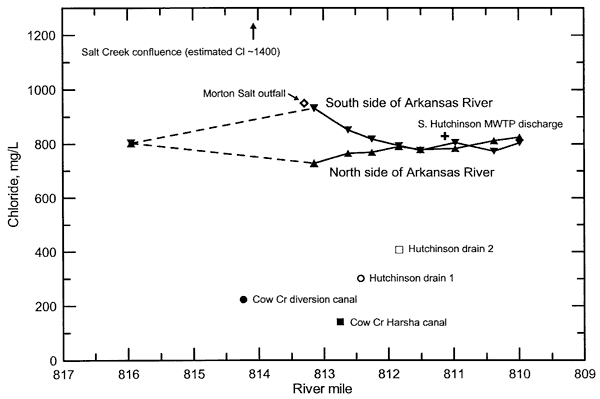
Three small inflows to the north side of the Arkansas River were observed and sampled during the detailed profile during July 2002 (Figure 12). The Harsha canal, which is a split from Cow Creek, had very little flow and a chloride concentration less than 200 mg/L. The flow was so low (a couple gal/min) that it probably was affected by interaction with the shallow ground water underlying the floodplain of the Arkansas River. There were two drains from which water was flowing from the south side of Hutchinson into the Arkansas River. The first drain is a pipe with a cover allowing response to storms but protection from backflow from the Arkansas River when high, and located between the Highway 96 bridge and the next bridge to the east that can be accessed from the southern end of Main Street. Only a few gal/min of flow was observed when it was sampled and nearly all of the flow disappeared in the drainage gully between the pipe outflow and the Arkansas River. The chloride concentration of the drain water was 301 mg/L. The second drain is located on the south side of the levee between Carey Park and the Arkansas River. The flow was several gal/min when sampled and was large enough that most of the flow entered the Arkansas River instead of seeping into the subsurface between the pipe and the river. The chloride concentration of this drain water was 407 mg/L. The chloride contents of both drain waters were substantially less than the chloride concentration of the Arkansas River in July 2002.
Figure 11 also includes points for the discharge from the municipal wastewater treatment plants of South Hutchinson and Hutchinson and Figure 12 includes a point for the South Hutchinson effluent. The data for the points are the monthly averages for chloride content of the effluents obtained from the KDHE. The points for the effluents are plotted at the approximate locations where the discharge enters the Arkansas River based on a KDHE map of the location of the NPDES sites. The chloride concentration of the South Hutchinson effluent, which is located on the south side of the river, was substantially greater and slightly greater than the chloride content of the south side of the Arkansas River in March and July 2002, respectively. The effluent may be responsible for elevating the chloride concentration of the south side of the river relative to the north side in the vicinity of the discharge. The Hutchinson effluent, which is on the north side of the river, had a lower chloride concentration than that of the river in March 2002. The discharge would be expected to decrease the chloride concentration of the north side relative to the south side of the river downstream of the discharge entrance during low flow conditions of the river.
The river profiles in both the late winter and summer of 2002 indicate that a distance of about a mile or more is required for an inflow to one side of the Arkansas River to become relatively well mixed across the broad, shallow river channel. In some locations through the Hutchinson area, the river channel splits into two separate channels separated by sand bars during low flow periods. These also extend the complete mixing of waters entering different sides of the river to farther downstream.
Identification of chloride sources
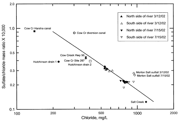
Chloride, bromide, and sulfate are the most conservative constituents (least affected by chemical reactions, including adsorption) dissolved in the surface and ground waters of the study area. Graphs of bromide/chloride and sulfate/chloride versus chloride concentration have been found to be valuable for identifying different sources of salinity in water resources (Whittemore, 1995). Figures 13 and 14 display mass ratios of bromide/chloride and sulfate/chloride versus chloride concentration for the samples collected for the Arkansas River profiles in the Hutchinson area during March and July 2002. The dashed and solid lines on Figure 13 represent the mixing of two end-member waters. The mixing curves are generated from use of two simultaneous mixing equations of the form
Cmix = C1V + C2 (1-V)
where Cmix is the concentration of a constituent in the mixture of two end-member waters, C1 and C2 are the concentrations of the constituent in each of the two end members, and V is the volume fraction of the first end member water. The equation is solved for V from 0 to 1 for each of the two constituents in the ratio of interest (such as sulfate and chloride) and the results for each constituent combined to give the ratio data versus chloride concentration for the mixing curve.
Figure 13. Bromide/chloride mass ratio versus chloride concentration for water samples collected for the Arkansas River profiles of March 12 and July 15, 2002.
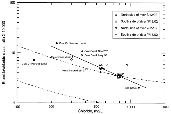
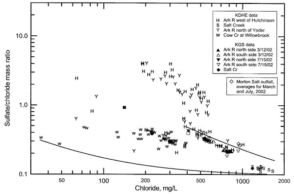
Figure 14. Sulfate/chloride mass ratio versus chloride concentration for water samples collected for the Arkansas River profiles of March 12 and July 15, 2002, and for ther Morton Salt outfall to the Arkansas River.
The two dashed curves in the bromide/chloride graph (Figure 13) represent the boundaries of a zone of mixing of fresh ground waters with natural saltwaters derived from dissolution of rock salt in the Great Bend Prairie to the west of Hutchinson. The two mixing curves bound data for monitoring well waters sampled for a salinity study of the High Plains aquifer and underlying Permian bedrock in eastern Stafford County, northeastern Pratt County, western Reno County, and the southwestern comer of Rice County in Groundwater Management District No. 5 (GMD5) (see Whittemore, 1993, 1995). The mixing zone boundaries provide a good reference for the mixing of freshwaters with natural saltwaters in the Hutchinson area because the main, natural source of chloride in the Arkansas River and the underlying and adjacent alluvial aquifer is either the same and very similar to that in the GMD5 area. The solid line in Figure 13 represents a mixing curve passing through the middle of the main point groups for the two sets of Arkansas River waters.
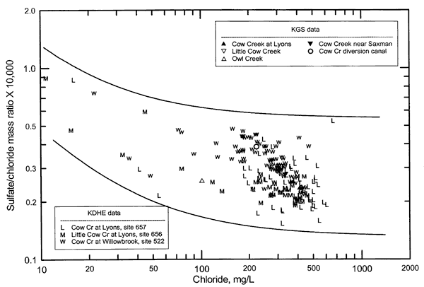
The point for the Salt Creek sample on Figure 13 plots within the mixing zone of freshwater with natural saltwater derived from dissolution of Permian rock salt. The point for the March sample of the Arkansas River west of Hutchinson (extension of 4th Avenue) plots on the upper boundary for the freshwater-Permian saltwater mixing zone and the point for the July sample lies just below the upper boundary (Figure 13). The group of points for the March samples for other sampling locations on the Arkansas River plots just above the upper boundary of the mixing zone, whereas points for all except one of the July samples plot on or near the upper boundary. The solid mixing curve is extended to chloride concentrations smaller and greater than for the Arkansas River samples. The extension to a higher chloride concentration and a bromide/chloride ratio the same as that of the Salt Creek water indicates that the chemical character of ground water providing baseflow to the river, which mixes with water with a lower chloride content and greater bromide/chloride ratio to give the mixing curve fitting the main group of river points, is similar to that of Salt Creek. The chloride concentration of the end of the solid curve is 1,360 mg/L. The solid line in Figure 14 for sulfate/chloride versus chloride represents a mixing curve similar to the solid line in Figure 13. Extension to the same sulfate/chloride ratio as that of the Salt Creek sample also gives a chloride concentration of approximately 1,360. The extension of the solid line to lower chloride concentration than for the March samples indicates that the type of water that mixes with the saline ground water has additional bromide than that expected by diluting the natural saline ground water with natural fresh ground water similar to that in the High Plains aquifer to the west (i.e., the low chloride part of the curve lies above the upper dashed mixing curve).
The points for the two samples collected on March 12, 2002 from the Arkansas River west of Hutchinson (KDHE site 523) overlie one another and have the lowest bromide/chloride ratio of the river waters for that date (Figure 13, Table 3). The point for the water sampled from same site on July 15, 2002 had a bromide/chloride ratio next to the lowest for the river waters for that date. The points for the first samples collected downstream from KDHE site 523 on the south side of the Arkansas River for both dates are represented by the open triangles that are the most separated (higher chloride and bromide/chloride ratio) from each of the two groups of points for the Arkansas River samples. Points for these same samples on Figure 14 are represented by the symbols plotting at the highest chloride concentration for each of the two groups of Arkansas River samples. Points for the Morton Salt outfall lie at even higher chloride values on Figure 14. The relationship of the points on Figures 13 and 14 and the larger volume of the Morton Salt outfall in comparison to that expected for the low flow of Salt Creek suggest that the outfall is the primary cause for the increase in chloride concentration at the sampling locations on the south side of the river just downstream from the Salt Creek and outfall confluence. The greater sulfate/chloride ratio of the Morton Salt outfall than for the July samples of the Arkansas River appears to explain the location of the point above the solid mixing line for the first sample of the south side of the Arkansas River downstream of the outfall. The outfall could also be responsible for the higher bromide/chloride ratios for the Arkansas River samples just downstream of the outfall in comparison with the other river samples.
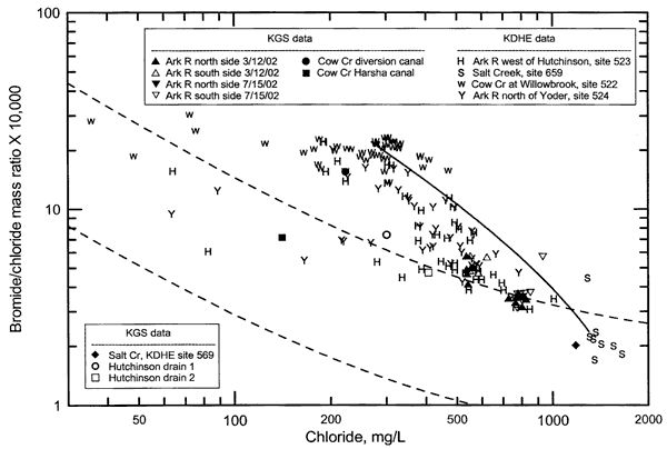
Figures 15-18 (bromide/chloride) and 19 and 20 (sulfate/chloride) display points for combined KGS and KDHE data on mass ratio versus chloride concentration plots for the Arkansas River and input waters in the Hutchinson area. The dashed and solid curves on the figures are mixing curves. Figure 15 shows points for only the Arkansas River and Salt Creek. Figure 16 includes points for the same Arkansas River and Salt Creek data as for Figure 15 but also has points for Cow Creek and storm drain inputs to the river. The data for KDHE site 522 (Cow Creek at Willowbrook) are used to represent the chemistry of the main volume input of Cow Creek water that flows through the western diversion canal to the river. Figure 17 has the same points as in Figure 16 but also includes symbols representing samples of Cow Creek southeast of Hutchinson (KDHE site 287). The successive figures were designed to help the reader discern the different patterns in the point distributions rather than presenting only one figure with all the points (Figure 17).
Figure 15. Bromide/chloride mass ratio versus chloride concentration for water samples collected by the KGS and KDHE from the Arkansas River in the Hutchinson area and Salt Creek.
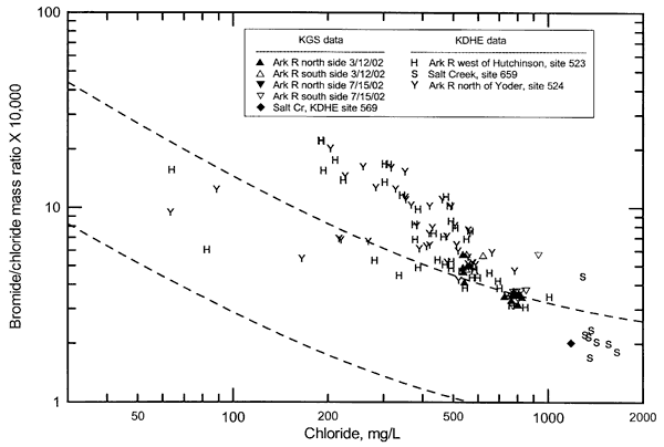
Figure 16. Bromide/chloride mass ratio versus chloride concentration for water samples collected by the KGS and KDHE from the Arkansas River in the Hutchinson area, Salt Creek, and Cow Creek at Willowbrook and the diversion canals west of Hutchinson.
Nearly all KDHE chloride and bromide/chloride data for Rattlesnake Creek, which enters the Arkansas River at the beginning of the Gar-Peace Subbasin, and Peace Creek, which flows into the river between Rattlesnake and Salt creeks, would plot as points within the freshwater-Permian saltwater mixing zone (dashed curves). This indicates the similarity in the natural Permian saltwater source providing chloride to all three of these creeks that enter the south side of the Arkansas River.
The distribution of most of the points for the Arkansas River in Figures 15-17 above the upper boundary of the zone of mixing between freshwater and saltwater derived from dissolution of rock salt in the Great Bend Prairie indicates that fresh or slightly saline water with a higher bromide/chloride ratio than in the Prairie is mixing with the saltwater end member. The distribution of many of the points for Cow Creek at Willowbrook suggests that Cow Creek might contribute to that higher bromide/chloride input. The solid mixing curve in Figure 16 has as its low chloride end member a ratio and chloride value representing the group of points for Cow Creek at Willowbrook with higher bromide/chloride ratio and chloride concentration than most of the other points, and as its high chloride end member values in the main group of Salt Creek data. Much of the curve lies above most of the points for Arkansas River waters. If the high-chloride end member of the curve were selected to be similar to the values for the July 2002 samples of the Arkansas River through Hutchinson, the curve would pass close to many of the points for the Arkansas River waters that lie above the upper dashed curve. Although the Cow Creek input appears to fit an end member that could explain the bromide-chloride chemistry, the volume of Cow Creek flow to the Arkansas River is not usually great enough to substantially impact the chemistry of the much larger Arkansas River flow. Thus, although some of the elevation of bromide/chloride ratios above the upper dashed mixing curve in Figures 15-17 is expected to be due to Cow Creek input, there is a more important water source controlling the chemistry during many periods.
Figure 17. Bromide/chloride mass ratio versus chloride concentration for water samples collected by the KGS and KDHE from the Arkansas River in the Hutchinson area, Salt Creek, and Cow Creek at Willowbrook, in diversion canals, and southeast of Hutchinson.
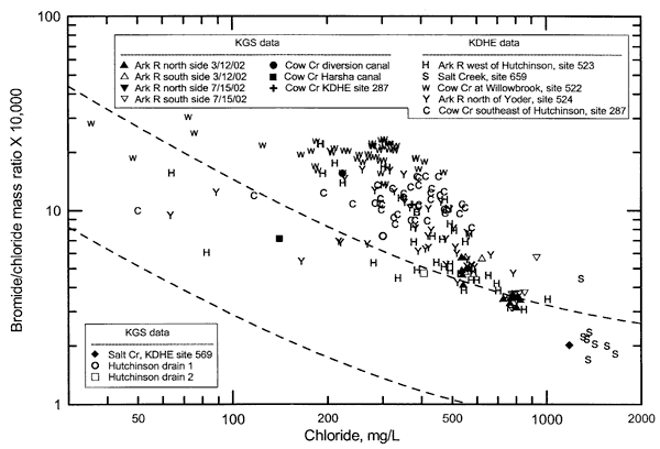
Figure 18. Bromide/chloride mass ratio versus chloride concentration for water samples collected by the KGS and KDHE from the Arkansas River in the Hutchinson area and at Dodge City, and Salt Creek.
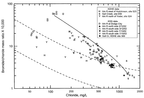
Figure 18 indicates the more important water source that often controls the chemical composition of Arkansas River in the Hutchinson area. The graph includes the same points as in Figure 15 but also displays points for Arkansas River waters at Dodge City sampled and analyzed by the KGS (Whittemore, 2000). The low chloride end member for the mixing curve in Figure 18 represents points with higher bromide/chloride ratios and chloride concentrations for the Arkansas River at Dodge City, and the high chloride end member represents Arkansas River low flows similar to Salt Creek waters. Several of the points for the Arkansas River near Hutchinson lie on or close to this mixing curve, in general, the greater the flow of the Arkansas River at Dodge City, the lower the bromide/chloride ratio and chloride concentration of the river water. Low-chloride end points selected for larger flows at Dodge would be expected to plot at lower bromide/chloride ratios and chloride concentrations than that used for the mixing curve in Figure 18. Use of such end points with the same high-chloride end point as in Figure 18 would produce a series of mixing curves that would pass through the rest of the points for the Arkansas River in the Hutchinson area that lie above the upper dashed line. The volume of such flows from the upper Arkansas River flowing past Dodge City have been substantial enough to appreciably change the chemistry of the river near Hutchinson.
Figure 19. Sulfate/chloride mass ratio versus chloride concentration for water samples collected by the KGS and KDHE from the Arkansas River in the Hutchinson area and at Dodge City, and Salt Creek, and by Morton Salt from their outfall to the Arkansas River.
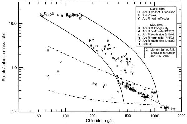
Figure 20. Sulfate/chloride mass ratio versus chloride concentration for water samples collected by the KGS and KDHE from the Arkansas River in the Hutchinson area, Salt Creek, and Cow Creek at Willowbrook, and by Morton Salt from their outfall.
Figures 19 and 20 illustrate the variation in sulfate/chloride ratio with chloride concentration for Arkansas River waters, Salt Creek, and the Morton Salt outfall in the Hutchinson area. Figure 19 includes points for the Arkansas River at Dodge City; except for the addition of the Morton Salt outfall, the points are for the same samples as in Figure 18. The two solid mixing curves in Figure 19 bracket a zone of mixing of upper Arkansas River waters passing Dodge City with low-flow waters of the Arkansas River in the Hutchinson area without the upper Arkansas River water. The mixing line with short dashes represents mixing of water with a chemistry the same as for Salt Creek with lower chloride waters. This line passes through the middle of both groups of points for the KGS low-flow samples collected from the Arkansas River in 2002 and is the same as part of the mixing line on Figure 14. The two mixing curves with the longer dashes enclose points represent a zone of mixing of freshwaters entering the Arkansas River in the Hutchinson area and not influenced by the upper Arkansas River with low flows of the Arkansas River.
Figure 20 includes points for Cow Creek at Willowbrook but not for the Arkansas River at Dodge City. The two curves bracket the zone of mixing of Cow Creek waters with Salt Creek type water and Arkansas River low flow at Hutchinson not affected by upper Arkansas River water. The sulfate/chloride ratios of the Cow Creek water are too low to be a source causing the high sulfate/chloride ratios of Arkansas River waters in the Hutchinson area. The points for high sulfate/chloride ratios at chloride concentrations between about 200 and 600 mg/L on Figures 16 and 20 generally represent the same samples. Therefore, although mixing of Cow Creek water with very low flow saline water in the Arkansas River appears to fit points for intermediate chloride concentrations in the Arkansas River with higher bromide/chloride ratios, mixing based on sulfate/chloride ratios does not fit these points. Comparison of the two figures shows the value of considering the results of both bromide/chloride and sulfate/chloride ratios for the study area when assessing salinity sources.
Relative importance of environmental and anthropogenic loads
The chloride concentration of the Arkansas River exceeded 250 mg/L during the decade of May 1992 to April 2002 in 50 out of 60 samples (83%) collected at site 523 west of Hutchinson, and in 52 out of 62 samples (84%) at site 524 southeast of Hutchinson. The average chloride contents during this period were 449 and 436 mg/L for sites 523 and 524, respectively.
The predominant chloride source in the Arkansas River in the Gar-Peace Subbasin is natural intrusion of saltwater derived from dissolution of rock salt in the Permian bedrock in the Great Bend Prairie to the west of Hutchinson. The saltwater discharges from the Permian bedrock into the High Plains aquifer (including recent alluvial parts of the aquifer along the Arkansas River) and then flows into tributaries feeding the Arkansas River and directly into the river from the alluvial aquifer. When the Arkansas River is not flowing at Dodge City, only a few to several percent of the chloride load in the river water at the monitoring station west of Hutchinson (site 523) is expected to be from non-natural sources during most low-flow conditions. Thus, over 90% of the chloride load at site 523 is expected to be from natural sources. The expected anthropogenic sources are primarily the NPDES wastewater effluents from municipal wastewater treatment plants and industries discharging into the river, such as those at Great Bend, Ellinwood, Sterling, and Nickerson. The probable major source of the chloride in the municipal effluents is expected to be water-softener salt and the other substantial source would be the natural chloride in the public supply water. The percentage of the chloride load from waste discharges is generally greatest during low flow conditions because the waste discharges usually do not vary much in flow and composition in comparison with the river, and the total chloride load in the river increases greatly with flow.
When the Arkansas River is flowing substantially past Dodge City during conditions when the flow in the Arkansas River would ordinarily be low, as much as 50% of the chloride load at KDHE site 523 can come from the upper Arkansas River water. These conditions can occur during a dry summer in south-central Kansas when rain and snow melt in the headwaters of the Arkansas River in Colorado are great enough to allow large flows across the Kansas line. Such high flow from Colorado typically has a very high sulfate content (typically greater than 1,000 mg/L) and a moderate chloride concentration (usually less than 100 mg/L). This chloride concentration is relatively low in comparison with that of the saline ground-water discharge to the river in southeast Barton, southwest Rice, and north-central Reno counties. During conditions when the percentage contribution of chloride loads in high flows from the upper Arkansas River to the total chloride load in the river near Hutchinson is at a maximum, the chloride concentration of the river near Hutchinson could be as low as 150 mg/L. If the Arkansas River flow in the Hutchinson area were about 1,000 cfs, the chloride load would be about 400 ton/day for these conditions. This load is approximately 2-4 times the load observed during the low-flow sampling of March and July 2002. Wastewater sources would contribute proportionately smaller percentages of the total chloride load in comparison to the amounts described below that occur during periods of low flow and no upper Arkansas River flow. The source of the chloride in the upper Arkansas River waters flowing from Colorado is natural, although the chloride concentration has been substantially increased as a result of consumption of water by evapotranspiration associated with water storage and irrigation use in Colorado.
Between monitoring site 523 west of Hutchinson and site 524 southeast of Hutchinson there are three NPDES effluents that enter the Arkansas River (Morton Salt, South Hutchinson MWTP, and Hutchinson MWTP, in downstream order), and a drain ditch with an NPDES permit for Shield Industries, in addition, the flow from the Cow Creek diversion canal diverts most of the flow of Cow Creek into the Arkansas River. The Cow Creek flow includes anthropogenic inputs (see below under the Cow Creek Subbasin). The average chloride loads of the waste discharges for January 2000-September 2002 for Morton Salt, South Hutchinson, and Hutchinson were 20.6, 2.1, and 8.5 ton/day, respectively. Table 7 lists the mean flow, chloride concentration, and chloride load for these same NPDES discharges during March and July 2002, and the mean daily flow, chloride content, and chloride load for the Arkansas River on the dates of the KGS low-flow sampling. The actual flows and thus, loads, are probably somewhat greater at KDHE site 523 than estimated because the Arkansas River is expected to have gained flow from ground-water discharge between Nickerson and site 523. In addition, there is a small amount of flow and chloride load from the Nickerson MWTP discharge. Tables 8 and 9 show the relative percentage of the NPDES flows and chloride loads compared to the Arkansas River at the KDHE monitoring sites 523 and 283. The flow at the USGS gaging station north of Haven was 114 cfs on 7/15/02. The flow at the USGS station at Maize was 137 cfs on 3/12/02 and 115 cfs on 7/15/02.
Table 7. Flow, chloride concentration, and chloride load data for NPDES sites and the Arkansas River in the Hutchinson area.
| Location description | Date | Flow, mean daily or mean monthly, cfs |
Chloride, sample or mean monthly, mg/L |
Chloride load, ton/day |
|---|---|---|---|---|
| NPDES, Morton Salt | Mar 2002 | 9.35 | 946 | 23.8 |
| NPDES, Morton Salt | July 2002 | 7.95 | 981 | 21.0 |
| NPDES, South Hutchinson MWTP | Mar 2002 | 0.927 | 773 | 1.93 |
| NPDES, South Hutchinson MWTP | July 2002 | 1.16 | 829 | 2.59 |
| NPDES, Hutchinson MWTP | Mar 2002 | 7.33 | 437 | 8.65 |
| NPDES, Hutchinson MWTP | July 2002 | 7.43 | 405 | 8.11 |
| Arkansas River, KDHE site 523, west of Hutchinson |
3/12/02 | 73 | 542 | 107 |
| Arkansas River, KDHE site 523, west of Hutchinson |
7/15/02 | 62 | 803 | 134 |
| Arkansas River, KDHE site 283, north of Haven |
3/12/02 | 128 | 552 | 191 |
Table 8. Relative flow of NPDES sites compared to the Arkansas River in the Hutchinson area. The percentage flow at Nickerson is the NPDES discharge relative to the sum of the flow at Nickerson and the NPDES discharge. The percentage flow north of Haven is the NPDES discharge relative to the flow north of Haven.
| Arkansas River, USGS gaging site |
Date | Flow of NPDES discharge relative to river, % | |||
|---|---|---|---|---|---|
| Morton Salt | South Hutchinson MWTP |
Hutchinson MWTP |
Total of 3 discharges |
||
| At Nickerson | 3/12/02 | 11.4 | 1.3 | 9.1 | 19.4 |
| At Nickerson | 7/15/02 | 11.4 | 1.8 | 10.7 | 21.1 |
| North of Haven | 3/12/02 | 7.3 | 0.7 | 5.7 | 13.8 |
| North of Haven | 7/15/02 | 7.0 | 1.0 | 6.5 | 14.5 |
Table 9. Relative chloride load of NPDES sites compared to the Arkansas River in the Hutchinson area. The percentage load at Nickerson is the NPDES load relative to the sum of the load at Nickerson and the NPDES load. The percentage load north of Haven is the NPDES discharge relative to the load north of Haven.
| Arkansas River, KDHE site |
Date | Load of NPDES discharge relative to river, % | |||
|---|---|---|---|---|---|
| Morton Salt | South Hutchinson MWTP |
Hutchinson MWTP |
Total of 3 discharges |
||
| 523 west of Hutchinson | 3/12/02 | 18.2 | 1.8 | 7.5 | 24.3 |
| 523 west of Hutchinson | 7/15/02 | 13.5 | 1.9 | 5.7 | 19.1 |
| 283 north of Haven | 3/12/02 | 12.5 | 1.0 | 4.5 | 18.0 |
The wastewater discharges from Morton Salt and the South Hutchinson and Hutchinson MWTP's comprised as much as about 20% of the combined flow of the discharges plus the Arkansas River measured at Nickerson during the low-flow conditions of late winter and mid-summer of 2002 (Table 8). These NPDES discharges constituted approximately 14% of the flow north of Haven during these low-flow conditions. Assuming a relatively linear increase in the flow from ground-water discharge and tributary inflow between these stations, this indicates that the wastewater discharges contributed between 15% and 20% of the river flow passing between Hutohinson and South Hutchinson. Based on this same assumption of flow increase and on the data in Table 9, the three NPDES wastewaters can comprise as much as about 20% of the chloride load in low flow of the Arkansas River passing between Hutchinson and South Hutchinson.
The NPDES discharge from Morton Salt contributes the largest flow and chloride load of the three wastewaters input to the Arkansas River in the Hutchinson area. The source of the water used by Morton Salt in its operations is ground water pumped from wells in the vicinity of the plant southwest of Hutchinson to the south of the Arkansas River. The wells are generally located between the plant and the river, thus they are relatively close to the river. Monitoring well data of the KDHE assembled by the KDHE for the Hutchinson area shows that the ground water in the unconsolidated deposits in Sections 23 (in which Morton Salt is located), 22 (the section to the west of 23), and 26 (the section to the south of 23) contains chloride concentrations from 867 to 4220 mg/L. Points for the bromide/chloride ratio and chloride concentration of these waters would plot within or on the upper boundary of the zone of mixing between freshwater and salt-dissolution brine such as drawn on Figures 15-18. Studies of the saline ground water in the Hutchinson region by the KGS indicate a similar range in chloride and bromide/chloride values for ground waters in the unconsolidated aquifer south of the Arkansas River; the more saline waters are located at the bottom of the aquifer above the Permian bedrock.
The wastewater from Morton Salt does not include process waste saltwater but consists primarily of non-contact cooling water with a small amount of dilute condensate water. The wastewater is reported to have a slightly smaller chloride concentration than the ground water as a result of dilution by the condensate water that offsets any water lost during the cooling process. The ground water at the location of the Morton Salt wells would be expected to flow approximately to the southeast in the general direction of the Arkansas River if unaffected by pumping wells. The ground water would eventually discharge to the river during low-flow periods somewhere in the lower Arkansas River basin downstream of the plant location. Thus, chloride in the wastewater from Morton Salt would enter the river as a part of the long-term natural discharge of ground water if the plant were not operating. If the pumping by Morton Salt has created a cone of depression in the water table sufficient to induce local recharge of the alluvial aquifer by river water, some of the chloride in the wastewater could be recycled river water. The net effect of the Morton Salt plant discharge is primarily a change in the rate and timing of movement of the ground-water chloride to the Arkansas River.
As indicated earlier in the section on identification of chloride sources, the Morton Salt outfall is the logical explanation for the higher chloride and bromide/chloride values observed in the KGS samples on the south side of the Arkansas River downstream of the outfall. The type of water use and the similar chloride concentration for the supply and wastewater of Morton Salt suggest that the bromide/chloride ratio would not have changed much between supply and wastewater discharge. Thus, another explanation is needed for the somewhat higher bromide/chloride ratio observed in the river waters downstream of the outfall compared to the other river water samples and to the solid mixing curve on Figure 13.
Salt processing started in the vicinity of the Morton Salt plant in 1898. During the late 1800's and the early 1900's, salt (halite) was commercially produced in the Hutchinson area by evaporating brines obtained by salt-solution mining. The process of crystallization of purified salt from evaporation pans generated a waste brine with a higher bromide/chloride ratio than in the original salt solution because chloride is preferentially removed relative to bromide during the salt (halite, NaCl) crystallization. After much halite was precipitated from brine spread in large pans, the waste brine was drained to prevent precipitation of additional salts that would decrease the purity of the halite (Kirk, 1899). The disposal of much of the waste brine in the early period of salt production apparently was at the surface, as reflected by the saltwater contamination of the alluvial aquifer found by Williams (1946) to the east and southeast of Hutchinson. The bromide/chloride ratio of the evaporation pan waste has been estimated by Whittemore (1990) to be about 0.0008 ±0.0002 (Br/Cl x 10,000 of 8 ±2). If the disposal of waste brine at the Morton Salt plant location was into ditches to the river similar to that for the other salt plants in the area during the early years of salt production, the pan brine would have contaminated the ground water in the area. With time, the contamination would slowly disperse, with some discharging to the river. Remnants of this brine mixed with the natural chloride source in the ground water could be drawn in by the water supply wells of Morton Salt. Such a mixture could explain the higher bromide/chloride ratio for the Arkansas River samples collected by the KGS in 2002 from the south side of the river downstream of the Morton Salt outfall in comparison with the other river samples in the area. Analysis of the supply waters of Morton Salt could determine whether this explanation is valid.
The waste effluents from both the South Hutchinson and Hutchinson MWTP's contain chloride concentrations that are greater than the source water used by the municipalities. As in the case of the Morton Salt outfall, the source water chloride in the South Hutchinson and Hutchinson supplies would eventually discharge to the river in the Lower Arkansas Basin. One probable source of additional chloride in the municipal wastewaters is water-softener salt. Other sources could include industrial wastewaters entering the cities' wastewater systems. The chloride concentration of the South Hutchinson wastewater, which is almost twice that of the Hutchinson discharge, suggests a substantial input of some type of industrial discharge with high chloride content. Otherwise, a very large rate of water-softener salt use would be required to produce the additional chloride present. If the natural chloride content of the ground-water supplies for the cities is about 100 mg/L, then the chloride loads added by anthropogenic activities to the river in the wastewater discharges during March and July 2002 are approximately 1.7 and 2.3 ton/day, respectively, for South Hutchinson, and 6.7 and 6.1 ton/day, respectively for Hutchinson. The total anthropogenic load additions for these cities comprises up to an estimated 6-7% of the total chloride load in low flow of the Arkansas River in the stretch between the two NPDES discharge locations.
The chloride concentrations of samples from the Arkansas River north of Haven were similar to those upstream north of Yoder. However, the bromide/chloride ratios were slightly greater for the waters north of Haven than north of Yoder. This observation fits the input of Cow Creek water and ground-water discharge from the evaporation pan waste plume extending southeast from Hutchinson into the river between the sampling locations. The chloride concentration of the input to the river is expected to be in a similar range as found in the river during the low-flow sampling. The anthropogenic affect on the river in this area is thus related to the composition of Cow Creek (see sections below) and the ground-water plume. In the absence of anthropogenic effects on Cow Creek and the ground water in the Equus Beds aquifer in this area, the river-water chloride concentration would have been expected to decrease as the fresher ground water diluted the upstream salinity. Low flows of Cow Creek where it enters the Arkansas River north-northeast of Yoder are expected to be on the order of 10-15 cfs for conditions of March and July 2002 based on the sum of industrial discharges released to the creek and the chloride concentration at KDHE monitoring site 287. The estimated contribution of Hutchinson industrial discharges in Cow Creek to the total chloride load of the Arkansas River north of Haven was at least 6% and 7% during March and July 2002, respectively.
Crop irrigation is not expected to have a significant impact on chloride loads in the Gar-Peace Subbasin. Consumption of water by evapotranspiration during irrigation would increase the chloride concentration of the remaining water. There is no known irrigation return flow that directly enters the Arkansas River or tributaries in the Gar-Peace Subbasin. The water with increased chloride from irrigation would infiltrate through the soils underlying the fields until reaching the water table. Precipitation recharge would dilute this return flow through the soil. The net effect would be to increase the chloride concentration of the ground water somewhat. The discharge of this ground water to tributaries and the Arkansas River would increase the chloride concentration of the river water slightly. However, the consumption of the pumped irrigation water would decrease the ground-water discharge by a small amount to the tributaries and river. Thus, the mass of the chloride discharging to the river would be the same but it would be dissolved in a somewhat smaller volume.
Cow Creek Subbasin
Chloride profile along Cow Creek
The upper drainage area of the Cow Creek Subbasin includes the Cow Creek headwaters and Little Cheyenne Creek in eastern Barton County that join at the Barton-Rice county line. The chloride concentration in the low flow of the fall of 1999 was substantially greater in Little Cheyenne Creek (678 mg/L, Table 5) just upstream of the confluence with Cow Creek than in Cow Creek (261 mg/L) just above the confluence. The chloride content (2,573 mg/L) of Little Cheyenne Creek was substantially greater upstream near where it starts at the end of the outlet canal from Cheyenne Bottoms. However, the flow was very small at this location in comparison with that just upstream of the confluence with Cow Creek. Surface waters collected from the 5 main pools of Cheyenne Bottoms had a chloride concentration range of 651-1,090 mg/L when sampled in November 1985 and 1,820-3,660 mg/L in April 1986 (Whittemore and Huggins, 1987). If the outlet water reflects these values or a wider range of salinity, then substantial outlet flows from Cheyenne Bottom could appreciably affect the chloride content and load of Cow Creek.
Cow Creek downstream of the confluence with Little Cheyenne Creek and the juncture of Calf Creek but upstream of the Plum Creek inflow had a chloride content of 536 mg/L in the fall of 1999. Plum Creek water upstream of the confluence with Cow Creek contained 215 mg/L dissolved chloride. The chloride concentration of Cow Creek about two miles south of Lyons, and upstream of the juncture of Little Cow Creek, was 411 mg/L. Additional samples in the Cow Creek watershed were collected later in the fall of 1999 (Table 5) to determine the salinity input from Spring Creek, which drains a large oil field that has known contamination of ground water from produced brine. The chloride content of Spring Creek was 530 mg/L just upstream of the confluence with Cow Creek, and of Cow Creek just above the join was 554 mg/L. Thus, Spring Creek flow had a similar chloride value to that of Cow Creek and did not act to dilute Cow Creek flow as did Plum Creek.
Little Cow Creek was sampled at two different times during the fall of 1999. Essentially all of the flow derived from the MWTP of Lyons. The chloride concentration (433-434 mg/L) was the same (within analytical error) for both samples. Owl Creek drains the Lyons area; the small flow in the creek contained 101 mg/L. Although the drainage includes the area of the salt plant, the sampling location is about one stream mile above the confluence with Cow Creek at the most downstream location that can be sampled from a public road. Thus, it did not include downstream industrial discharges to Owl Creek before it joined Cow Creek, if any were active at the time. The chloride content of Cow Creek about one mile northwest of Saxman, and a few stream miles downstream of the Owl Creek junction, was 335 mg/L, indicating that a substantial amount of water with a lower chloride content had mixed with the Cow Creek and Little Cow Creek waters (411 mg/L and 433 mg/L dissolved chloride, respectively). The chloride value for the KDHE sample from Cow Creek at Willowbrook (site 522) on 11/15/99 was 272 mg/L. Cow Creek flow at the USGS gaging station south of Lyons was 8.3 cfs on 10/7/99 when the KGS collected the sample near Saxman and 8.7 cfs on 11/15/99 when the KDHE collected the sample at Willowbrook. The flow varied between 5 and 12 cfs between the two sample dates. Thus, the flow conditions appear very comparable. The lower chloride concentration of Cow Creek at Willowbrook compared to that near Saxman (a linear distance of about 15 miles) indicates further addition of fresher water, which is expected to be primarily ground-water discharge in that stretch of the creek.
Water in the diversion canal on the west side of Hutchinson, which appears to divert most of the Cow Creek flow to the Arkansas River, had a chloride concentration of 223 mg/L on 7/15/02 (Table 5). The flow of Cow Creek south of Lyons on that date was 4.3 cfs. The very small flow of the Harsha Canal to the Arkansas River at that time had a different chemistry and was not expected to represent Cow Creek water but interaction with shallow ground water in the Arkansas River alluvium. Water in the main channel of Cow Creek that passes through Hutchinson contained a chloride content of 374 mg/L at the Highway 50 bridge to the southeast of Hutchinson. This was the same chloride concentration observed by the KGS for Cow Creek several stream miles downstream at KDHE site 287 on 3/12/02. The chloride value of the KGS sample was within the range of the two KDHE samples (387 mg/L on 2/18/02 and 350 mg/L on 4/15/02) bracketing the date of the KGS sample from site 287.
The range in chloride values observed by the KDHE for Cow Creek south of Lyons during 1992-2002 is 16-669 mg/L, and at Willowbrook during 1990-2002 is 22-470 mg/L. Chloride concentrations averaged 366 mg/L and exceeded 250 mg/L in Cow Creek near Lyons in 46 of the 58 samples (79%) collected by the KDHE during the decade of July 1992 to June 2002. Chloride concentrations averaged 247 mg/L and exceeded 250 mg/L in Cow Creek at Willowbrook in 34 of the 61 KDHE samples (56%) collected during the decade of May 1992 to April 2002. The sample data show that the chloride content last exceeded 600 mg/L south of Lyons in 1999 and 400 mg/L at Willowbrook in 1998. The chloride concentration range for the KDHE record for site 287 for 1985-2002 is 50-705 mg/L. The chloride value last exceeded 500 mg/L at this site in 1998. The chloride concentration range was 50-705 mg/L for KDHE samples collected during 1985-2002 from Cow Creek at site 287 southeast of Hutchinson. Chloride contents averaged 387 mg/L and exceeded 250 mg/L at site 287 in 56 of the 62 KDHE samples (90%) collected during the decade of May 1992 to April 2002.
Identification of chloride sources
There are a variety of chloride sources in the Cow Creek Subbasin and the type and mixture of these sources are somewhat different from those along the Arkansas River in the Hutchinson area. Chloride sources in the Subbasin are discussed separately for three different parts of the Cow Creek watershed to help clarify differences. The three areas are the upper part of the watershed downstream to water-quality monitoring site 657 on Cow Creek south of Lyons, the lower middle portion of the Subbasin from site 657 to site 522 on Cow Creek at Willowbrook, and the lowermost part of the Cow Creek system from site 522 to the three split discharges to the Arkansas River.
The upper part of the Cow Creek Subbasin includes the headwaters of Cow Creek in northeast Barton County and the watershed of Cheyenne Bottoms in central and northwest Barton County. Figures 21 and 22 show points for stream waters from Cow Creek and its tributaries down to site 657 south of Lyons. The graphs also include points for surface water from the 5 pools of Cheyenne Bottoms and ground water from observation wells sampled in 1985 and 1986 for a KGS and Kansas Biological Survey study of water quality in the Bottoms (Whittemore and Huggins, 1987). Figure 21 displays the same dashed curves for the mixing of fresh ground water and natural Permian saltwater from salt dissolution in the Great Bend Prairie as shown in Figures 13 and 15-18. The solid curves in Figures 21 and 22 represent a zone of mixing of freshwater with saline water that brackets all of the Cow Creek and tributary stream waters. The bromide/chloride ratios of the Cow Creek and tributary samples with a chloride concentration over 200 mg/L are substantially greater than the ratios that would be expected for a chloride source that was predominantly rock salt dissolution.
Figure 21. Bromide/chloride mass ratio versus chloride concentration for water samples collected by the KGS and KDHE from Cow Creek and its tributaries downstream to Lyons, and by the KGS from wells in Cheyenne Bottoms.
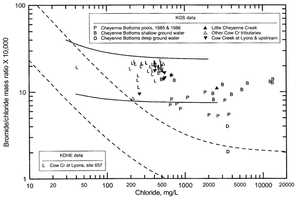
Figure 22. Sulfate/chloride mass ratio versus chloride concentration for water samples collected by the KGS and KDHE from Cow Creek and its tributaries downstream to Lyons, and by the KGS from wells in Cheyenne Bottoms.
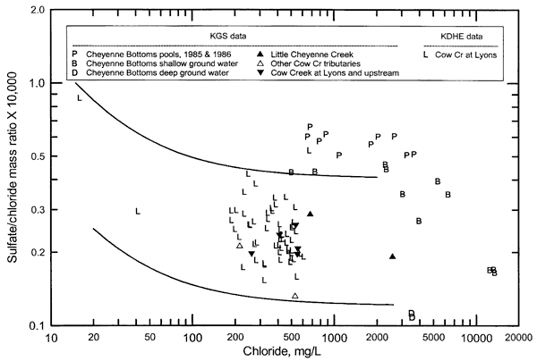
The bromide/chloride and sulfate/chloride ratios of the Little Cheyenne Creek samples collected for this study lie within the zones of mixing that fit the points for the downstream samples of Cow Creek. The bromide/chloride and sulfate/chloride ratios were greater, the chloride concentration substantially lower (Figures 21 and 22, Table 5), and the flow much greater for the Little Cheyenne Creek water near the confluence with Cow Creek than for the creek water near the end of the Bottoms outlet canal. The bromide/chloride ratios of the Cheyenne Bottoms pool waters in 1985 and 1986 were too low and the sulfate/chloride ratios too high to fit as a main source of the chloride for the recent low flow samples from Little Cheyenne Creek. If the chemistry of the pool waters was similar to that in 1985-1986 when the creek waters were recently collected, then outflow of pool waters could not explain the chemistry of the creek water. Figures 21 and 22 also show points for ground waters from shallow (8-15 ft deep) observation wells immediately south of Bottoms pools and a deep (72 ft) well within the Bottoms. The bromide/chloride and sulfate/chloride ratios for some of the ground waters fit as a possible source for the chloride in Little Cheyenne Creek near the outlet canal.
The bromide/chloride and sulfate/chloride ratios increased in Little Cheyenne Creek water from near the outlet canal to near the Cow Creek junction. The bromide/chloride ratio for Little Cheyenne Creek near Cow Creek is greater than the ratios of any of the shallow ground waters immediately south of the Bottoms, whereas the sulfate/chloride ratio is less than those for most of the shallow ground waters. This suggests that discharge to the creek of ground water with a chemistry similar to that of the shallow ground water south of the Bottoms could explain the higher sulfate/chloride ratio but not the greater bromide/chloride ratio. The drainage area of Little Cheyenne Creek includes oil fields between the outlet canal and the confluence with Cow Creek. Oil-field brines in south-central Kansas typically have bromide/chloride ratios that are greater than 0.002 (20 as Br/Cl x 10,000) and typically in the range 0.003-0.005. Oil brines in Kansas usually have sulfate/chloride ratios substantially less than 0.1. Thus, past contamination of ground waters by oil-field brine might contribute some of the chloride to Little Cheyenne Creek.
The data for the Bottoms and Little Cheyenne Creek suggest that ground-water discharge with a natural source of salinity provides the predominant source of chloride in the creek. The sediments underlying the Bottoms area consist primarily of Quaternary clay, silt, and fine sand. The Dakota Formation is exposed along the margins of the Bottoms area and extends under the Quaternary sediments. Upper Cretaceous strata form the bedrock higher in the drainage basin. Permian rocks that contain saltwater underlie the Dakota Formation. Slow intrusion of saltwater from the Permian into the overlying Dakota strata and upwards into the Quaternary fill probably provide some of the chloride that was then concentrated in the ground water by evapotranspiration. The bromide/chloride ratio of the deep well water has the lowest bromide/chloride ratio of the ground waters, fitting a salt-dissolution source mixed with a water with a higher ratio. The higher bromide/chloride ratios of the shallow ground water suggest that the chloride content of fresh runoff from the Bottoms watershed, with higher bromide/chloride ratios than that of the water providing the chloride source to the deep well, was concentration by evapotranspiration over a long time. The salinity source for Cheyenne Bottoms is described further in Whittemore and Huggins (1987).
During high rainfall periods when pool flow in the outlet canal could be substantial, the chemistry of Little Cheyenne Creek would be expected to be controlled substantially by this outflow. Resampling and analysis of the pool waters would be needed to determine whether the present composition is now closer to that of the Little Cheyenne Creek water during low flow. The importing of water into Cheyenne Bottoms from the Arkansas River and Walnut Creek increases the long-term average water levels in the Bottoms in comparison with pre-settlement conditions. The chemistry of the water imported affects the quality of water in the pools into which it is diverted. Thus, bromide/chloride and sulfate/chloride ratios could be expected to vary in the pool waters depending on the mixture of Bottoms watershed drainage and imported water.
The low-flow sample of Cow Creek collected above the confluence with Little Cheyenne Creek had a chloride content of 261 mg/L (Table 6). Possible sources of chloride in the watershed include natural ground water discharging from the Upper Cretaceous shales and limestones in the upper part of the drainage area, ground-water discharge from the Dakota aquifer farther downstream closer to the sampling point, oil-field brine, and water-softener salt dissolved in the municipal wastewater effluent of Claflin. The Dakota aquifer becomes increasingly saline towards northern Barton County where it is confined by overlying Cretaceous shales. Bromide/chloride ratios in natural Dakota saltwaters are similar to those for natural saltwaters in underlying Permian rocks because intrusion from the Permian provides the natural salinity in the Dakota. The bromide/chloride ratio for the sample above that of the freshwater and salt dissolution mixing zone (Figure 21) suggests that the low flow sample in this uppermost section of Cow Creek probably includes oil-field brine in addition to saline Dakota water and water-softener salt sources of chloride.
The substantially lower chloride concentration of Cow Creek upstream compared to downstream of the Little Cheyenne Creek junction, and the relatively similar bromide/chloride and sulfate/chloride ratios of the downstream waters compared to those of Little Cheyenne Creek, indicate that Little Cheyenne Creek water provides the predominant chloride source to the Cow Creek mixture. The Plum Creek water sampled during low flow had a chloride (215 mg/L) somewhat higher than expected for natural sources based on the geology. The Dakota aquifer generally contains ground water with a chloride concentration less than 100 mg/L in the watershed of this creek. Oil fields extend across much of the watershed area for the creek. The town of Bushton has an NPDES permit to discharge wastewater into Plum Creek. The small amount of additional chloride above expected natural sources is probably a mixture of oil brine and municipal wastewater.
Spring Creek had a chloride content of 530 mg/L when sampled in the fall of 1999. The bromide/chloride ratio of the sample was relatively high and the sulfate/chloride ratio low for the chloride concentration, fitting an oil-brine source. The creek drains a major oil producing area, the Chase-Silica Field. The early practice of disposing oil brines in surface ponds resulted in documented pollution of the unconsolidated sediments in the area. The disposed oil brines contained from several tens of thousands to over a hundred thousand mg/L dissolved chloride. The polluted ground water is slowly being diluted by natural recharge and is flushed to Spring Creek. Although Spring Creek carried a high chloride concentration when sampled, the chloride content (554 mg/L) of Cow Creek just upstream was higher. The relative flow rate of Spring Creek was substantially smaller than that of Cow Creek when sampled, thus, the largest chloride source in Cow Creek water downstream of Spring Creek was still expected to be the input from Little Cheyenne Creek. The oil-brine inputs to Cow Creek in northwest Rice County keep the bromide/chloride ratio in the same general range as but generally decrease the sulfate/chloride ratio relative to that of the Little Cheyenne Creek input.
Cow Creek water sampled south of Lyons in the fall of 1999 had a higher bromide/chloride ratio and a lower sulfate/chloride ratio than the ratios for the inflow of Little Cheyenne Creek to Cow Creek (Figures 21 and 22). This fits the discharge of ground water contaminated with oil-field brine between the junction with Little Cheyenne Creek and Lyons. The chloride concentration in Cow Creek decreased from 536 mg/L above the confluence with Plum Creek to 411 mg/L south of Lyons, indicating that there was sufficient fresher ground-water discharge to the creek and its tributaries in this stretch to cause dilution. The total load is expected to have been greater at Lyons than upstream due to the chloride inputs along the stream and the greater flow. Although the flow was low when the sample from Cow Creek at Lyons was collected by the KGS in the fall 1999, the water contained a substantially lower chloride content than many KDHE samples at similar flow (Figure 8). This indicates that there are conditions in which the proportion of flow from sources and parts of the watershed with discharges containing higher chloride concentrations is greater than occurred on the October 7. Examples of such conditions could include a large input of high chloride water from Little Cheyenne Creek relative to other tributaries and a larger flushing release of water contaminated by oil-brine from a selected tributary. The higher bromide/chloride and lower sulfate/chloride ratios for the KDHE samples with greater chloride concentration at Lyons than for the KGS fall 1999 sample, and the greater bromide/chloride and smaller sulfate/chloride ratios for the fall 1999 sample at Lyons than for Little Cheyenne Creek near the confluence with Cow Creek suggest that oil-field brine is the major contributor to the additional chloride in most of the KDHE samples with chloride above that of the KGS sample.
Bromide/chloride and sulfate/chloride versus chloride relationships for the upper part of the lower half of the Cow Creek Subbasin are displayed in Figures 23 and 24. The figures include the same points for Cow Creek south of Lyons (KDHE site 657) as in Figures 21 and 23. The solid curves bracket all of the Cow Creek data for samples collected south of Lyons and at Willowbrook (site 522), and represent the boundaries of a zone of mixing of freshwater with different chloride sources.
Figure 23. Bromide/chloride mass ratio versus chloride concentration for water samples collected by the KGS and KDHE from Cow Creek and its tributaries from Lyons downstreamm to Willowbrook.
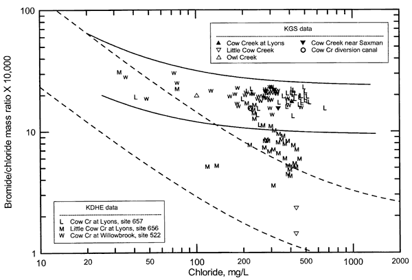
Figure 24. Sulfate/chloride mass ratio versus chloride concentration for water samples collected by the KGS and KDHE from Cow Creek and its tributaries from Lyons downstreamm to Willowbrook.
The predominant source of chloride in the low flow of Little Cow Creek south of Lyons is dissolved water-softener salt in the municipal wastewater effluent of Lyons as indicated by the very low bromide/chloride ratios that plot within the zone of mixing of freshwater and salt-dissolution brine (dashed curves in Figure 23). The effluent discharges to the creek upstream of the sampling point; during the fall of 1999 when sampled, the creek had no flow at the first county road bridge upstream of the wastewater discharge location. The bromide/chloride ratio of samples of Little Cow Creek analyzed by the KDHE and with chloride concentrations greater than 300 mg/L ranged up to values that were at the lower solid curve in Figure 23. The increase in bromide/chloride ratios with little change in chloride concentration suggests contributions of water with a high bromide/chloride ratio during low flows. The most logical source of such an input is oil brine; the lower part of Cow Creek flows through an oil field. Higher flows with lower chloride concentrations fit the mixing of freshwater with various mixtures of the municipal wastewater and saline water affected by oil brine. The sulfate/chloride ratios for chloride values greater than 300 mg/L for Little Cow Creek are distributed from the middle to the lower part of the zone bracketed by the mixing curves (Figure 24). This distribution and the location of the points for lower chloride concentrations are consistent with the interpretation from the bromide/chloride graph.
The sample of Owl Creek water collected in the fall of 1999 was fresh. The location of the point on Figure 23 above the zone of mixing of freshwater and salt-dissolution brine indicates that there is (are) a low concentration chloride source(s) with a higher bromide/chloride ratio than for dissolved salt. Potential sources in addition to salt-processing waste with a higher bromide/chloride ratio could include runoff from the City of Lyons and the gas field within the watershed of Owl Creek. The sample was collected at the most downstream county road bridge on the Creek and was downstream of outfall 1 but upstream of outfall 3 below the salt plant to the southeast of Lyons.
The chloride concentration and the bromide/chloride ratio of the fall 1999 sample of Cow Creek near Saxman were lower than the values for Cow Creek south of Lyons. The lower concentration indicates that water with a lower chloride content mixed with the water flowing downstream from Lyons. The smaller ratio indicates that additional water could have been affected by a salt-dissolution source of chloride. This is consistent with mixing with the municipal wastewater that formed the flow in Little Cow Creek. However, the chloride concentration of Little Cow Creek was greater than the Cow Creek water at Saxman indicating that fresher discharge entered Cow Creek between the confluence with Little Cow Creek and Saxman.
Chloride concentrations in low flows of Cow Creek at Willowbrook have usually been much lower than for south of Lyons on the same date during the period 1992 to 2002 based on KDHE data for stream monitoring sites 522 and 657. Chloride values for high flows are typically either essentially the same (within analytical error) or smaller at Willowbrook than near Lyons. The range in bromide/chloride and sulfate/chloride ratios was somewhat less for Cow Creek at Willowbrook than south of Lyons for chloride concentrations exceeding 100 mg/L. The data indicate that the variation in the percentage of salinity sources with different chemical compositions is greater in Cow Creek near Lyons than at Willowbrook. The main change between Lyons and Willowbrook is the discharge of fresher water to Cow Creek that dilutes and tends to homogenize the water chemistry at Willowbrook relative to that south of Lyons. Although the flow was low in the fall of 1999, Cow Creek at Willowbrook contained a substantially lower chloride content at that time than many of the other KDHE samples for low streamflow at the site. As stated earlier for the similar observation for Cow Creek near Lyons, this indicates that there are conditions in which the proportion of flow from discharges in parts of the watershed containing higher chloride concentrations is greater than occurred on October 7. In addition to the conditions described earlier that could cause higher chloride inputs to Cow Creek south of Lyons, there are possible flushing events or high chloride discharges that could occur from the area of present and past salt mining and processing operations and oil production in the stretch between Lyons and Willowbrook. The relatively similar ranges in bromide/chloride and sulfate/chloride ratios of Cow Creek at Lyons and Willowbrook for high chloride concentrations makes it difficult to differentiate between sources above Lyons and those between Lyons and Willowbrook. Points for many of the Willowbrook samples on Figures 23 and 24 could be generated by simple mixing of freshwater with Cow Creek water at Lyons.
Points for water samples from the lowermost part of the Cow Creek Subbasin (Cow Creek at Willowbrook to the Arkansas River) are shown in Figures 25 and 26. The figures include the same points for Cow Creek samples at Willowbrook as in Figures 23 and 24. The point for the summer 2002 sample of the Cow Creek diversion canal west of Hutchinson plots within the ranges of both bromide/chloride and sulfate/chloride values. Although the flow was low when collected, the water contained a substantially lower chloride content than many of the KDHE samples at Willowbrook for low streamflow. The greater bromide/chloride and smaller sulfate/chloride ratios of most of the KDHE samples of Cow Creek at Willowbrook in comparison to the 2002 sample of the Cow Creek diversion, and the earlier explanation for higher chloride concentrations for KDHE data versus the KGS 1999 sample near Lyons, suggest that oil-field brine is the main source of additional chloride for the KDHE samples above that of the 2002 diversion sample. The average and range in the chloride content of the municipal wastewater discharge from Willowbrook was 661 mg/L and 380-915 mg/L, respectively, during January 2000 to September 2002. However, the average flow during this period was 0.019 cfs, a volume too small to substantially increase the chloride content of low flows with several cfs. Although higher creek flows would have lower chloride concentrations, they would also have even greater chloride loads relative to the small, more constant load of the wastewater effluent. As described earlier, the Harsha canal sample (collected from a very small flow near its entrance to the Arkansas River) probably was discharge of ground water from the Arkansas River alluvium near the river, thereby representing more closely river water that had entered the alluvium during past higher river flows than Cow Creek water.
Figure 25. Bromide/chloride mass ratio versus chloride concentration for water samples collected by the KGS and KDHE from Cow Creek from Willowbrook downstream through the diversion canals and Hutchinson to the Arkansas River.
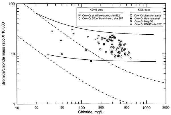
Figure 26. Sulfate/chloride mass ratio versus chloride concentration for water samples collected by the KGS and KDHE from Cow Creek from Willowbrook downstream through the diversion canals and Hutchinson to the Arkansas River.
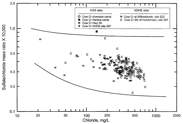
Many samples of Cow Creek southeast of Hutchinson have chloride concentrations that are greater than those in the creek at Willowbrook. Most of the creek samples collected southeast of Hutchinson have bromide/chloride ratios that are lower than those for obtained at Willowbrook (Figure 25) but that plot above the zone of mixing of freshwater with salt-dissolution brine. Most of the Cow Creek samples southeast of Hutchinson have sulfate/chloride ratios within the same range as those for Cow Creek at Willowbrook, although there are a few samples with greater than 100 mg/L chloride that have either higher or lower ratios than for the creek at Willowbrook. Assuming that some of the Cow Creek water at Willowbrook flows in the modified channel through Hutchinson most of the time, the change in bromide/chloride ratio to southeast of Hutchinson can be explained as a mixture of creek water at Willowbrook with discharge additions in the City of Hutchinson area that have a predominant chloride source derived from salt-dissolution or salt processing. Salt processing refers to the waste brine left after crystallizing halite (NaCl) from dissolved rock salt. As described earlier, the bromide/chloride ratio of the process waste brine is elevated relative to that in the original salt solution. Much of the waste brine from the evaporation pans used during the early years of salt production was disposed at the surface, and contaminated ground water in the alluvial aquifer to the east and southeast of Hutchinson (Williams, 1946). The bromide/chloride ratio of the evaporation pan waste is expected to be about 0.0008 ±0.0002 (Br/Cl x 10,000 of 8 ±2) as estimated by Whittemore (1990) and observed in a chloride plume in the aquifer to the southeast of Hutchinson. This ratio is in the same range as that for the Cow Creek samples southeast of Hutchinson with the lowest bromide/chloride ratios. Given the same chloride concentration, a smaller volume of a chloride source primarily representing dissolved salt without processing (with a bromide/chloride ratio within the dashed curves in Figure 26) would be needed as a mix with Cow Creek water at Willowbrook to decrease the bromide/chloride ratio to that observed southeast of Hutchinson than for a chloride source primarily consisting of salt-crystallization waste.
The two samples of Cow Creek collected by the KGS in 2002 were at different locations southeast of Hutchinson separated by about 4 miles of linear distance. The chloride concentrations at the two locations were the same although one was sampled in the spring and the other sampled during the summer. The bromide/chloride and sulfate/chloride ratios of the samples were relatively similar in comparison with the ratio ranges for the KDHE samples (Figures 25 and 26). This suggests that there was not much change in the chemistry of Cow Creek between the two locations during this period. The bromide/chloride ratios of the two KGS samples are in the lower range of those for the KDHE samples, and sulfate/chloride ratios in the upper range of those for the KDHE samples. This suggests either that some of the samples from Cow Creek southeast of Hutchinson with chloride in the same range as for the KGS samples primarily represent Cow Creek water upstream of Hutchinson or that there are some waste effluents in Hutchinson with higher bromide/chloride and lower sulfate/chloride ratios that vary substantially in discharge rate. The substantially greater chloride concentrations for many KDHE samples at site 287 than observed during the KGS sampling could represent similar conditions as described in the previous sentence, i.e., the source could be events with high chloride concentration inputs upstream of Hutchinson or larger discharges of high chloride waters within the Hutchinson area such as the NPDES effluents. Evaporation pan waste from past salt processing has contaminated some of the ground water along Cow Creek southeast of Hutchinson. Discharge of this contaminated ground water to the creek should not vary substantially in composition and is expected to have a bromide/chloride ratio range similar to the lower ratios observed for KDHE samples from site 287.
Relative importance of environmental and anthropogenic loads
Up to 80% of the chloride content of low flows in Cow Creek near Lyons is interpreted as from natural sources. Much of the natural chloride source appears to be from ground-water discharge to Little Cheyenne Creek south of Cheyenne Bottoms. Substantial chloride loads could be released from Cheyenne Bottoms during wetter conditions, thus, anthropogenic activities could affect the amounts and timing of the chloride loads through management practices affecting Bottoms outlet flows. The natural sources are ultimately derived mainly from ground waters that leached chloride from marine sediments and rocks or dissolved rock salt in the subsurface. A small amount of chloride leached from soils and decomposing plant matter comes from atmospheric chloride accumulated over thousands of years during periods when evapotranspiration exceeds rainfall.
The largest anthropogenic source of chloride loads in Cow Creek south of Lyons is oil-field brine pollution. The oil brine contributes up to an estimated 10-20% of the chloride load during low-flow conditions at this site based on evaluation of the bromide/chloride and sulfate/chloride ratio data. There are many old oil fields in the watershed of Cow Creek above the Lyons sampling site. The early practice of disposing oil brines in surface ponds in these old fields resulted in pollution of the unconsolidated sediments, including the High Plains aquifer, in the area. The disposed oil brines contained from several tens of thousands to over a hundred thousand mg/L dissolved chloride. The polluted ground water is slowly being diluted by natural recharge and is flushed to tributaries and the main stream of Cow Creek by ground-water discharge. Smaller oil-brine sources could include more recent spills and brine-line leaks. The oil-brine contribution is expected to slowly decrease with time. The greater the flow in the creek, the larger the percentage of the chloride load expected from natural sources and the smaller the percentage from oil brine.
A known and substantial area of oil brine contamination in the Cow Creek drainage basin is in the area of the town of Chase where the Chase-Silica Field is located. Pages 42-48 of KGS Bulletin 85 [Fent, O.S., 1950, Geology and ground-water resources of Rice County, Kansas: Kansas Geological Survey, Bulletin 85, 142 p., available online] include a description of oil-brine contamination of ground water in Rice County. A statement regarding a particular location of ground-water pollution from oil brine that was about 3 miles southeast of Chase and about 1.5 miles southwest of Cow Creek indicates that the surface disposal of oil brine extended from the mid-1930's through at least 1946 and probably a little later. Other oil fields that started in the 1930's and early 1940's in the Cow Creek drainage upstream of the Chase and Lyons areas also probably caused some ground-water contamination. Some of the early contamination of Cow Creek in the 1930's could have included locations where some oil brine was released into ditches or escaped during breaks in berms around surface disposal ponds. The maximum discharge of chloride into Cow Creek from ground-water contamination probably occurred during the late 1940's to early 1950's. Most of the contamination by ground-water discharge in the early period would have been from the soils and shallow aquifers such as the alluvium of the streams. Most of the oil-brine chloride input to Cow Creek today is probably from deeper ground water contaminated by dense brines that penetrated into the subsurface aquifer. This discharge takes a longer time to flush. For example, KDHE data for a well in the Chase area show an increasing chloride content in the latter part of the 1900's that fits the migration of an oil-brine contamination plume.
The rate of decline of the oil-field input to chloride in Cow Creek is difficult to estimate. However, a logical assumption is that the shape of the oil-brine chloride decrease could be similar to an exponential decay curve. The maximum contamination of Cow Creek from a ground-water discharge source would be expected to be after the period of surface disposal of oil brine because time would be required for the ground-water contamination to flow through the most permeable unconsolidated sediments to nearby stream drainages. If the oil-brine chloride contribution from ground-water discharge decreases exponentially, and mo equals the mass of chloride at the peak of oil-brine contamination of Cow Creek from ground-water discharge during 1950 and m equals the mass at time t, then
m = m0ekt
log m/m0 = kt
and
log m = kt
if m0= 1, where k is a constant, t is time, and log refers to natural logarithm. If the chloride input from ground-water discharge with an oil-brine source to Cow Creek in 1950 was twice that in 2000, then
log 0.5 = 50k
and k = -0.01386. In 10 more years (the year 2010), the mass can be calculated using a t of 60 from
log m = -0.0139t
giving m = 0.435. This would be about a 13% decrease from the year 2000. In 20 years the mass would be 0.378 or 24% smaller than in the year 2000. In another 50 years (the year 2050) the mass would be 0.25 or half what it is now. Thus, if the decay were exponential according to the above calculation, in another 50 years (the year 2050) the contribution of the oil-brine source to the total chloride in Cow Creek near Lyons for flow conditions might have decreased to about 5-10%.
Oil and gas fields are also present in the drainage basin area of Cow Creek downstream of KDHE site 657 south of Lyons, including in the watersheds of Little Cow Creek and Jarvis Creek (which enters Cow Creek near Saxman). The assessment of additional chloride added from oil brine based on bromide/chloride and sulfate/chloride data is difficult in the stretch of Cow Creek from Lyons to Willowbrook because the municipal and salt plant outfalls obscure the effect of oil brine. Accurate bromide/chloride data for the salt operation outfalls would be necessary to further evaluate the impact of oil brine in this stretch of Cow Creek. If the amount of oil-brine contamination is insignificant downstream of Lyons, the 10-20% contribution of oil brine to low flow chloride at the KDHE monitoring site south of Lyons is probably decreased proportionately to the downstream increase in flow. For example, if the flow rate of Cow Creek during low-flow conditions doubles from near Lyons to south of Willowbrook, then oil brine would be expected to contribute up to 5-10% of the chloride load in the creek south of Willowbrook. There are no significant old oil fields between the Cow Creek monitoring stations at Willowbrook and southeast of Hutchinson. Thus, oil-brine sources of chloride in Cow Creek through and southeast of Hutchinson would be derived from upstream of Hutchinson.
There are several small municipalities that have NPDES permits and release treated wastewater to the Cow Creek Subbasin. The wastewater from the facilities with lagoon disposal seeps into the ground water, delaying the eventual transport of the dissolved chloride to the streams, whereas others release the treated wastewater directly to streams. The wastewater from Hoisington enters the watershed of Cheyenne Bottoms. The discharge from Claflin in Barton County, Hollyrood and Lorraine in Ellsworth County, and Bushton and Chase in Rice County enter the ground water or directly into streams in the Cow Creek watershed upstream of KDHE monitoring site 657 south of Lyons. It is probable that use of water softener salt in the towns increases the chloride content of the wastewater discharge to the Cow Creek watershed. The total percentage of chloride from this source could possibly be a few percent or more during low flows at the Lyons monitoring station. Information on the specific discharge rate and location and chloride concentration of the effluents would be needed to estimate the chloride loads added to Cow Creek.
The largest wastewater discharge from municipalities in the Cow Creek Subbasin is at Lyons. The wastewater from the Lyons MWTP that discharges into Little Cow Creek before entering Cow Creek has averaged 0.56 cfs in flow and 434 mg/L in chloride content from January 2000 to September 2002. The chloride concentration (433 and 434 mg/L) in the two samples collected by the KGS from Little Cow Creek downstream of the MWTP discharge in 1999 was the same as this average. Based on the flow of Cow Creek recorded by the USGS, the Lyons wastewater contributed 7% of the total chloride load of the flow at the USGS gaging station south of Lyons on 10/7/99. Most of the chloride in the wastewater is from salt dissolution, probably as water-softener salt, as described earlier. If the small municipalities upstream of Lyons contribute a few to several percent of the chloride in Cow Creek water near Lyons, the total MWTP additions could contribute about 10% or more of the chloride load.
The average chloride concentration of the effluent from the Willowbrook MWTP (661 mg/L for January 2000 to September 2002) is greater than that in the Lyon discharge but the flow (0.0193 cfs) is much smaller. If the flow of Cow Creek at Willowbrook were about 14 cfs on 10/7/99 in comparison with the flow of 8.3 recorded by the USGS south of Lyons, and the chloride concentration at KDHE monitoring site 522 at Willowbrook were 300 mg/L, the Willowbrook effluent would constitute approximately 0.3% of the chloride load of Cow Creek. The values of 14 cfs and 300 mg/L were derived from adding the flow from IMC outfalls 1 and 2 and the additional flow needed to match the chloride concentration of the KGS sample collected on 10/7/99 near Saxman, and adding the flow of IMC outfall 3 and about 2 cfs of freshwater for ground-water discharge between outfall 3 and Willowbrook, Some of these calculations are described in the next paragraph. The chloride concentration of 300 mg/L is similar to many of the low-flow values determined by the KDHE for monitoring site 522 at Willowbrook. The KDHE chloride concentration for this site on 11/19/99 was 272 mg/L.
Industrial discharges to Cow Creek include those of IMC south and southeast of Lyons, Cargill in south part of Hutchinson, and Cessna-Baton in east Hutchinson. There are three IMC outfalls, one that enters Owl Creek south of Lyons about 1.5 miles upstream of the confluence with Cow Creek (outfall #1), another that enters Owl Creek about 0.5 mile upstream of the Cow Creek confluence (outfall #3), and one that flows into Cow Creek about 2 linear miles southeast of Saxman (outfall #2). The average flow and chloride concentration for the discharges during January 2000 to September 2001 were 0.830 cfs and 102 mg/L for outfall #1, 0.715 cfs and 124 mg/L for outfall #2, and 0.581 cfs and 697 mg/L for outfall #3. The Owl Creek sample collected by the KGS on 11/19/02 had a chloride content (101 mg/L) that was essentially the same as that of the average for outfall #1, which entered the creek upstream of the sampling location. Assuming that the IMC outfalls on 10/7/99 were similar to the recent averages, outfalls #1 and #3 in Owl Creek would comprise 12-13% of the total chloride load in the mix of Owl Creek and Cow Creek waters at their confluence on that date. The KGS sample of Cow Creek near Saxman on 10/7/99 was located upstream of outfall 2 and contained 335 mg/L chloride. If the only flow additions to Cow Creek from below Little Cow Creek to near Saxman were outfalls #1 and #3, the chloride content of the water would be 403 mg/L. Thus, there is additional flow with a lower chloride that dilutes Cow Creek water between Lyons and near Saxman. If the additional flow had a chloride concentration of 50 mg/L, then the added flow volume necessary to produce the chloride concentration of 335 mg/L would be 2.3 cfs. IMC outfall #2 enters Owl Creek downstream of the KGS sample collected near Saxman. If the average flow of 0.715 cfs for outfall #2 were added to the total flow (14.3 cfs) computed for the KGS sample located near Saxman, then the contribution of outfall #2 to the total chloride load would be 2% on 10/7/99. The total of the three outfalls would be comprise about 14-15% of the chloride load of Cow Creek just downstream of outfall #2.
The bromide/chloride and sulfate/chloride ratios for the IMC outfalls are unknown. However, the KGS sample of Owl Creek, which would have included outfall 1, had a bromide/chloride that plotted above the zone of mixing of freshwater with salt-dissolution brine. Outfall #2, which includes waters from Cow Creek alluvium contaminated by past salt-processing activities, would be expected to have a bromide/chloride ratio between that for pan evaporation waste brine and salt-dissolution brine. This ratio range would be substantially lower than the ratios observed in waters collected by the KDHE at Willowbrook. Some oil-brine contamination also occurs in the ground waters in the Saxman area. If some of this chloride source were incorporated in outfall #2 waters, it would elevate the bromide/chloride ratio a small amount above that expected for salt-dissolution and evaporation pan waste.
The NPDES discharges from Cargill and Cessna-Baton enter Cow Creek on the east side of Hutchinson. The average flow and chloride concentration of the Cargill discharge were 5.96 cfs and 538 mg/L for January 2000 to September 2002, and of the Cessna-Baton discharge were 2.76 cfs and 584 mg/L for October 2001 to September 2002. The average flow and chloride content of the Cargill effluent in March 2002 were 6.19 cfs and 481 mg/L and in July 2002 were 7.12 cfs and 558 mg/L. The average flow and chloride content of the Cessna-Baton effluent in March 2002 were 2.48 cfs and 535 mg/L. The July 2002 data for Cessna-Baton were not included in the KDHE spreadsheet for the NPDBS effluent but the averages for June and August 2002 were 2.09 cfs and 526 mg/L. The chloride contents observed in the KGS samples in Cow Creek southeast of Hutchinson in March (at KDHE monitoring site 287) and July 2002 (Highway 50 bridge) were both 374 mg/L. There is no flow data for these locations but the flows observed during the KGS sampling did not appear to be much more than the sum of the NPDBS discharges. These flows and the lower chloride concentration observed in Cow Creek indicate that a small amount of water with a substantially lower chloride concentration mixed with the industrial discharges. The chloride concentration range and average of the 9 samples of Cow Creek collected by the KDHE at site 287 from January 2001 to April 2002 are 240-391 mg/L and 337 mg/L. Most of the chloride load in the Cow Creek low flows at site 287 is expected to be from the industrial discharges.
An anthropogenic source of chloride that probably contributes to the load in Cow Creek southeast of Hutchinson is discharge of saline water from a ground-water contamination plume extending to the southeast from Hutchinson. The ground water is contaminated primarily by the waste brine from the evaporation pans of old salt plant operations in southeast Hutchinson. Some of the brine seeped into the subsurface and contaminated the ground water. Since that time, the contaminated ground water has slowly moved to form a plume lying along and to the north of Cow Creek southeast of Hutchinson. Some of this saline water is expected to discharge into Cow Creek during low-flow conditions. The higher bromide/chloride ratios of Cow Creek waters with chloride content over 300 mg/L at site 287 than expected for mixing with primarily salt-dissolution brine suggest that either much of the wastewater could be affected by old evaporation pan waste or there is some other source of additional bromide in the industrial NPDBS discharges. During higher flows when some Cow Creek water flowing past Willowbrook could pass through Hutchinson, the even greater bromide/chloride ratios for lower chloride concentrations would reflect oil brine sources of chloride in the Cow Creek waters southeast of Hutchinson.
There are several feedlot operations with NPDBS permits in the Cow Creek Subbasin. Although the chloride content of animal waste is substantially greater than that of the supply water used in livestock operations, the amount of additional chloride added to the system is not expected to be large, as it is in the case of water-softener salt in many municipal wastewaters and past contamination of ground waters by salt-processing wastes. Although some chloride would be derived from feed materials, much of the higher chloride concentration in the animal waste results from concentration of dissolved salts in the supply water as a result of water consumption during animal transpiration. Thus, much of the chloride in the waste is derived from supply water. However, the greater chloride concentration of the waste could lead to higher chloride concentrations in streams during low flows, either as treated wastewater released directly to streams or as ground-water, with higher chloride contents from wastewater infiltration, that contributes to baseflow. The contribution to chloride from these sources is expected to be a relatively very small component of the total chloride loads in the Cow Creek watershed.
The long-term use of water for irrigation from the High Plains aquifer in the watershed between the Lyons and Willowbrook monitoring sites can be expected to slowly increase the background concentration of chloride in the ground water. The consumptive use of water and return to the subsurface of much of the residual salt content of the water pumped could slowly raise the background chloride concentration of shallow water in the aquifer. The effect of the discharge of the affected water on Cow Creek will depend on such factors as how much of the residual salt is flushed from the soil during wet periods into high creek flows versus the amount that reaches the water table and becomes part of baseflow discharge to the stream. Although the effect of irrigation could be a small increase in the chloride concentration in Cow Creek during baseflow conditions, the load of the chloride would be the same because the primary effect of the irrigation is on the water volume, not the total chloride mass.
Prev Page--Data and Analysis || Next Page--References
Kansas Geological Survey, Geohydrology
Placed on web Feb. 3, 2006.
Comments to webadmin@kgs.ku.edu
The URL for this page is http://www.kgs.ku.edu/Hydro/Publications/2004/OFR04_05/03_data2.html