![]()
Prev Page--Contents || Next Page--Geography
Introduction
Purpose and Scope of Investigation
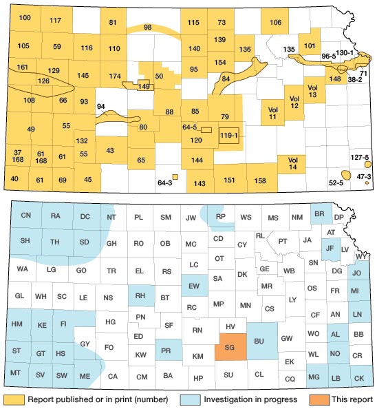
This report is part of a continuing program ground-water investigations in Kansas begun in 1937 by the U. S. Geological Survey and the State Geological Survey of Kansas in cooperation with the Environmental Health Services of the Kansas State Department of Health, the Division of Water Resources of the Kansas State Board of Agriculture, and the City of Wichita. The present status of the program is shown in Figure 1 [Updated figure shows status as of Jan. 1998].
Figure 1—Index map of Kansas showing area described in this report and areas covered by other groundwater reports.
The investigation of the geology and ground-water resources of Sedgwick County was made to determine the availability and quality of ground water for domestic, stock, municipal, industrial, and irrigation use and to determine the geologic and hydrologic factors that control the occurrence of ground water in the county. Ground water is one of the county's principal natural resources, and though supplies are adequate in most parts of it at present withdrawal rates, there is a need for definitive information on the distribution, quantity, and quality of the available water supply.
This report presents many of the basic geologic and hydrologic data needed to evaluate the quantity, quality, and distribution of ground water in the county and to enable sound engineering and administrative decisions to be made on the development and management of the resource.
Location and Extent of Area
Sedgwick County, in south-central Kansas, is bounded on the north by Harvey County, on the east by Butler County, on the south by Sumner County, and on the west by Kingman and Reno counties. The County contains 28 townships and has an area of about 1,000 square miles (Fig. 1).
Previous Geologic and Hydrologic Work
Permian System—Prosser (1897) discussed the history of geologic investigations of the Upper Permian rocks in Kansas and the stratigraphy of the Permian rocks in the Sedgwick County area. The lithologic character and stratigraphy of the Permian rocks have been described by Moore (1920), Bass (1929), Ver Wiebe (1937). Norton (1939), Swineford (1955), and Kulstad (1959).
Neogene System—A Pleistocene age for the unconsolidated silt, sand, and gravel in Sedgwick County and adjacent areas (Udden, 1891; Harnly, 1895) was established in the late 1800's by means of vertebrate fossils which were found in them (Cope, 1889, 1895: Udden, 1891; Lindahl, 1892; Williston, 1897). These deposits were called "Sheridan beds" (Scott. 1897) or "Equus beds" and were described by Haworth and Beede (1897) and Beede (1898). Additional vertebrate and invertebrate fossils of Neogene age from the area were collected and described (Deere, 1908; Hay, 1917, 1924; Nininger, 1928; Harnly, 1934; Mohler, 1938; Frye and Hibbard, 1941: Hibbard, 1948, 1956; and Taylor, 1960). Little geologic work was done in the area after the work of Haworth and Beede in 1897-98 until cooperative ground-water investigations were started by the State and Federal Geological Surveys in 1937. Preliminary results of this cooperative work were reported by Frye (1939), Lohman and Frye (1940), Moore, et al. (1940), and Frye and Hibbard (1941). A comprehensive report on the geology and ground-water resources of a part of south-central Kansas included the northern part of Sedgwick County (Williams arid Lohman, 1949). A report on the Pleistocene geology of Kansas (Frye and Leonard. (1952) discussed Sedgwick County and the surrounding area. The geology and ground water resources of adjacent counties have been described by Bayne (1956, 1960, 1962), Lane (I 960), and Walters (1961).
Hydrologic studies—The quality and availability of water in Sedgwick County and adjacent areas were studied and reported on by Parker (1911). Meinzer (1914) prepared a preliminary report on the availability of ground water for irrigation in the vicinity of Wichita. Lohman, et al. (1942) reported on the availability of ground-water supplies for national defense industries in south-central Kansas and included a brief description of the ground-water resources of Sedgwick County. Williams and Lohman (1947) summarized the methods used in estimating the ground water supply in the Wichita well-field area, which includes a part of Sedgwick County. A progress report (Stramel, 1956) on the hydrology of the Equus-beds area covered a part of the county. An investigation of saltwater contamination in Wichita was made by the Kansas State Board of Health (Jones, 1938). An observation-well program that included wells in Sedgwick County and adjacent areas was begun in 1937. Records of water level observations made during the program were published annually by the U. S. Geological Survey (U. S. Geological Survey, 1938 to 19561) and since that time have been published annually by the State Geological Survey of Kansas (Fishel arid Mason. 1957, 1958; Fishel, et al., 1959; Fishel and Broeker, 1960; Broeker and Fishel, 1961,1962).
Methods of Investigation
Field work for this report was begun in April 1957 and was completed in the 1959 field season. Intermittent field work has been carried on since that time as additional data from newly developed water supplies became available. Data were collected on 460 wells and springs in the county and these include the depth of the well, depth to water in the well, method and type of construction used, and the type and size of pumping equipment installed. Information concerning the yield of the well, adequacy of the supply, quality, and use of the water were obtained from the owners of the wells. Information on use of water in the county was obtained from well owners, when known, and from records of the Division of Water Resources of the State Board of Agriculture.
A total of 315 test holes were drilled during this investigation to determine the thickness and character of the water-bearing material. Of the test holes, 294 were drilled with a power auger and 21 with an hydraulic rotary drill. In addition to the test holes drilled for this investigation 17 drillers' logs and 23 sets of well cuttings from previous investigations (Williams and Lohman, 1949) were reexamined. Drillers' logs of 93 wells and 35 sets of drill cuttings were obtained from private contractors working in the area. Drill cuttings were examined and logged in the field and later examined microscopically in the office and then used to prepare lithologic strip logs. The location of all wells and test holes were determined by means of an automobile odometer, and the altitude of the land surface and measuring points at all sites were determined with a plane table and alidade.
The stage of the Arkansas River and its tributaries was measured at 43 points and the Ninnescah River and its tributaries at 14 points, to aid in preparation of the water-table contour map of the county (Pl. 1).
Samples of water were collected from 94 wells and test holes, 3 springs, and 10 surface streams for complete mineral analysis, and 130 samples for chloride analysis were collected from test holes. All water samples collected during this investigation were analyzed in the Water and Sewage Laboratory of the Kansas State Department of Health under the supervision of Howard A. Stoltenberg, Chief Chemist. In addition to the above water samples, analyses of all municipal and suburban water supplies in the county were obtained from the State Board of Health. Many complete and partial water analyses were obtained from Wichita and are so acknowledged.
The geology was mapped on aerial photographs obtained from the Agricultural Adjustment Administration. U. S. Department of Agriculture, or on topographic maps of the U.S. Geological Survey, and later transferred to a base map using a focalmatic projector for reduction.
The base map used was modified from one obtained from the Wichita-Sedgwick County Metropolitan Area Planning Commission. The roads shown on the base map were brought up-to-date from field observation. The drainage system was delineated from aerial photographs.
Well-numbering system
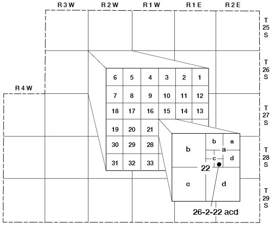
The wells, test holes, springs. and surface water sampling points reported here are numbered according to their location as determined by the General Land Office surveys and according to the following number-sequence: township, range section, quarter section, quarter-quarter section, and quarter-quarter-quarter section (10-acre tract). The subdivisions of a section are designated a, b, c, or d in a counterclockwise direction starting in the northeast corner. All townships in the county are south of the base line, hence no letter designation of north or south is necessary; however, the sixth principal meridian passes through the county and range numbers are followed by "E" or "W" with respect to this line. In the text of this report, only the east ranges are designated by letter. An example of the well-numbering system is given in Figure 2.
Figure 2—Outline map of Sedgwick County, Kansas, illustrating the well-numbering system used in this report. Location is Section 22, Township 26 South, Range 2 West, showing the method of dividing sections into quarter sections, quarter-quarter sections, and quarter-quarter-quarter sections.
Acknowledgments
Appreciation is expressed to the many residents of the county who supplied information on their wells and to the officials of the cities who furnished information regarding the municipal water supplies. Special acknowledgment is made to R. H. Hess, Director of Water and Sewage Treatment, to O. K. Brandon, Water Production and Treatment Superintendent, and to G. J. Stramel, Hydrologist, all of the City of Wichita, for making available all geologic and hydrologic data on the Wichita water-supply system.
D.R. Soder, Vice President, Layne-Western Drilling Company, and personnel under his supervision were especially cooperative in providing logs of many wells and test holes drilled in the county and in permitting formation samples to be collected during drilling operations. Special thanks are extended to officials of the Kansas Gas and Electric Company and to the U. S. Air Force. who supplied much information and many logs of wells and test holes drilled for their respective organizations.
The manuscript of this report has been reviewed critically by several members of the Federal and State Geological Surveys; by R. V. Smrha, Chief Engineer, and H.L. Mackey, Engineer, Division of Water Resources, Kansas State Board of Agriculture; and by J.L. Mayes, Chief Engineer, and Bruce Latta, Geologist, Environmental Health Services, Kansas State Department of Health.
Prev Page--Contents || Next Page--Geography
Kansas Geological Survey, Geology
Placed on web Nov. 1998; originally published Dec. 1965.
Comments to webadmin@kgs.ku.edu
The URL for this page is http://www.kgs.ku.edu/General/Geology/Sedgwick/intro.html