![]()
Prev Page--Geography || Next Page--Geologic Formations
General Geology
Summary of Stratigraphy
The rocks that crop out in Sedgwick County are of sedimentary origin and range in age from Permian to Recent. Rock exposures in the county are poor owing to the nature of the rocks and the lack of topographic relief. Much of the interpretation presented in this report is based on subsurface data and knowledge of geology in nearby areas.
The oldest rocks cropping out in the county are a part of the Wellington Formation of the Cimmaronian Stage of the Permian System. The Wellington forms the bedrock surface in about the eastern two-thirds of the county and is exposed at the surface along streams east of the Arkansas River valley and along the southern edge of the county where it is not covered by younger rocks. The Ninnescah Shale, also of the Cimmaronian Stage, forms the bedrock surface in about the western one-third of the county. It conformably overlies the Wellington Formation in this area. Topographic relief in this part of the county is more pronounced, and the Ninnescah Shale is exposed at many places in the valley walls of the Ninnescah River and its tributaries. However, the Ninnescah Shale is covered by younger rocks in the uplands.
The unconsolidated deposits of south-central Kansas, particularly north of Sedgwick County, in McPherson, Harvey, and Reno counties, described by Haworth and Beede (1897) and by Beede (1898) were named the "McPherson Equus beds." On the old edition of the geologic map of Kansas (Moore and Landes, 1937) the unconsolidated rocks are shown as alluvium, Quaternary deposits, and, in the upland west of the Arkansas Valley, as Ogallala (Tertiary). Williams and Lohman (1949) and Hibbard (1952) recognized the presence of Tertiary deposits, which they called the Delmore Formation, in a part of McPherson County. All deposits of Pleistocene age there except the alluvium and dune sand were included in the McPherson Formation. Frye, Leonard, and Swineford (1956, p. 57) recognized that the Delmore Formation had a local source, but they included these beds within the Ash Hollow Member of the Ogallala Formation on the basis of fossil evidence. In subsequent geologic work in conjunction with ground-water investigations in Kansas members of the Federal and State Geological Surveys have established a sequence of Pleistocene events that can be correlated with the classic glacial section of the Mississippi Valley. The stratigraphic sequence thus established will be used in this report insofar as possible, although the term "Equus beds" is well established by local usage to include all unconsolidated water-bearing deposits in Sedgwick County and adjacent areas irrespective of age.
Unconsolidated deposits of clay, silt, sand, and gravel believed to be equivalent to a part of the Pliocene Ogallala Formation unconformably overlie Permian rocks in the basal part of the valley fill of the Arkansas River. Similar deposits are present as isolated remnants underlying loess on the uplands west of the Arkansas Valley. These rocks are known to be exposed at only one locality in the county—in a creek channel in the uplands north of the city of Goddard but they have been penetrated by many water wells in the valley.
Deposits representing at least four major depositional cycles of the Pleistocene Series are present in Sedgwick County. These deposits range in age from the Early Pleistocene Holdrege Formation of the Nebraskan Stage to Recent alluvium and consist of unconsolidated clay, silt, sand, and gravel. The sediments of Pleistocene age unconformably overlie Neogene(?) and Permian rocks in the Arkansas Valley and Permian rocks in other stream valleys and the upland areas of the county.
A generalized section of the rocks significant to the occurrence of ground water in Sedgwick County is given in Table 2.
The areal geology of the county and the geologic cross sections of it are shown on Plates 1 and 2 respectively.
Table 2—Generalized section of geologic formations in Sedgwick County, Kansas, and their water-bearing properties. The formation classification is that of the State Geological Survey of Kansas.
| System | Series | Subseries | Stratigraphic units used in this report |
Max thick., feet |
Physical character | Water supply |
|---|---|---|---|---|---|---|
| Neogene | Pleistocene | Upper Pleistocene |
Dune sand (Recent) |
5 | Composed of fine to medium, silty sand. | Lies above the water table and thus yields no water to wells. |
| Alluvium and terrace deposits (Wisconsinan to Recent) |
45 | Composed of fine to coarse sand and fine to very coarse arkosic gravel containing only minor amounts of silt and clay that grade upward into clayey silt. Clay balls up to one foot in diameter are common in the sand and gravel. | Comprises the most widely used aquifer in the county and yields large supplies of very hard water to many wells. Well yields up to 2,000 gpm can be developed locally. Adjacent to the Arkansas River the water is too highly mineralized for many uses. | |||
| Colluvium (Illinoisan to Recent) |
30 | A heterogeneous mixture of silt, clay, sand, gravel, and bedrock fragments deposited by slope processes. | Generally above the water table and thus yields no water to wells. Where deposits are thick and contain sand and gravel lenses, wells yielding a few gpm may be possible but would be subject to failure in dry years. | |||
| Loess (Illinoisan to Recent) |
74 | Wind-deposited tan to pink-tan, calcareous silt, containing zones of caliche nodules and some sandy zones. | Generally above water table, but locally the basal part is saturated and sandy zones may yield some water to wells. | |||
| Terrace deposits (Illinoisan) |
75 | Composed of fine to coarse sand and fine to coarse arkosic gravel that grades upward into sandy silt. Sand and gravel beds locally contain silt and clay lenses, and clay balls up to one foot in diameter are common. | Well yields of 500 gpm of good quality water are generally available from the deposits, and locally yields up to 1,000 gpm can be obtained. | |||
| Lower Pleistocene |
Undifferentiated deposits (Nebraskan and Kansan) |
157 | Composed of light tan to light gray, commonly sandy, silt and clay, fine to coarse sand, and fine to coarse arkosic gravel. Locally contains a lenticular bed of volcanic ash, the Pearlette ash bed of late Kansas age. | Yield large quantities of good quality water to wells in the Arkansas Valley that are screened in multiple porous zones and penetrate the complete section of unconsolidated rocks. The water is highly mineralized locally near the Arkansas River. Where present in the uplands west of the Arkansas Valley, well yields up to 50 gpm are possible locally. | ||
| Pliocene | Ogallala (?) Formation |
150 | Composed of lenticular beds of calcareous, gray to pink-tan silt and clay, fine to coarse sand, and fine to coarse gravel. The sediments reflect two sources; arkosic sand and gravel beds derived from the west are interfingered in the northern part of the county with sand and gravel beds composed of gray to tan quartz and ironstone derived from Cretaceous rocks to the north. In subsurface only. | Contributes large supplies of good quality water to many municipal, irrigation, and industrial wells screened in multiple porous zones and penetrates the complete section of unconsolidated rocks. | ||
| Permian | Lower Permian |
Ninnescah Shale |
175 | Composed of alternating beds of brownish-red silty shale and siltstone, and a few thin beds of gray-green silty shale in lower part. Some gypsum is present as thin, cross-cutting and intersecting vein fillings. | Yields small quantities of water to many stock and domestic wells in the western part of the county. Water obtained from the weathered zone in the formation is generally of good quality. Water from deeper zones is generally highly mineralized but usable. | |
| Wellington Formation |
550 | Calcareous gray and blue shale containing several thin beds of impure limestone and thin beds of gypsum and anhydrite. Some beds of maroon and gray-green shale near top of Formation. The thick Hutchinson Salt Member is present near the middle of the Formation in the western part of the county. | Yields small quantities of highly mineralized water to many stock and domestic wells east of the Arkansas River valley and in south-central part of County. Moderately large water supplies of as much as 350 gpm are available from solution zones in gypsum beds near east County line. The water is highly mineralized but usable. |
Summary of Geologic History
Paleozoic Era
During Paleozoic time marine rocks of Cambrian and Ordovician age were deposited in central Kansas over igneous and metamorphic basement rocks. Rocks of Silurian and Devonian age probably were deposited over these older rocks and later removed by erosion after the pre-Mississippi uplift of the Ellis Arch (Central Kansas Arch). This arch extends from Chautauqua County on the Oklahoma line to the northwest through Ellis County. Rocks of Mississippian age were deposited over the arch and are unconformable upon Cambrian and Ordovician rocks. After deposition of Mississippian rocks, the area was again uplifted and part of the upper Mississippian rocks were deeply eroded. Following erosion, the area was again submerged, forming the Sedgwick Basin where Pennsylvanian and Permian rocks, about 3,500 feet thick, were deposited. After deposition of the Permian rocks, the area was again uplifted and subjected to a long period of erosion.
Mesozoic Era
Central Kansas, including Sedgwick County, was probably a land area during Triassic and Jurassic time, and no deposits of these periods are known in the area. Deposition was resumed in the area in Cretaceous time and Cretaceous rocks probably were deposited in Sedgwick County and removed by later erosion. No Cretaceous rocks are known to be present in the county, but they are present to the north in McPherson and Rice counties and to the west in Pratt and Stafford counties.
Cenozoic Era
Neogene Period
Pliocene Epoch
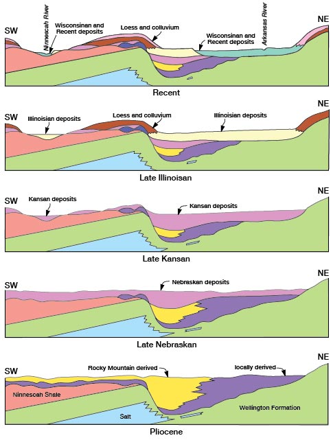
Uplift in the Rocky Mountains and tilting of older rocks in adjacent areas at the close of the Mesozoic Era started a long period of erosion by streams which flowed eastward from the mountains across Kansas, at least as far as the western edge of the Flint Hills, where they turned to the south and flowed in a depression formed in a belt of easily eroded Permian shales. The presence of thick, readily soluble salt beds in the Wellington Formation of Permian age was the controlling factor in the location of the major Neogene streams in Sedgwick and adjacent counties and in later deposition of sediments by these streams. The maximum eastward extent of salt beds in the Wellington is not known, but it was probably not farther east than the present city of Wichita. The salt beds probably did not crop out owing to their solubility, but must have been close to the surface over a large area, and Neogene streams cutting into the salt would have rapidly widened or deepened their valleys. The salt beds thicken and dip to the west, and the streams that were actively dissolving the salt would have shifted to the west at a decreasing rate as the salt beds became more deeply buried. Circulating ground water as well as stream action must have played an important role in development of the large north-south-trending depressional area in the Wellington Formation, for a closed depression about 300 square miles in area is present on the buried surface of the Wellington in parts of Sedgwick, Reno, and Harvey counties. The southern end of this closed depression in Sedgwick County corresponds with the 1,200-foot contour on Plate 3 which closes on both the north and south sides of a topographic saddle on the bedrock surface southwest of Wichita. Solution of salt by ground water with resultant settling of the overlying rocks is still taking place along the western edge of this broad depressional area as is attested to by a line of sinks that extends from near McPherson on the north to just northwest of Wichita. The sinks in Sedgwick County are shown as small lakes on the base maps of Plates 1 and 3.
The ancestral Arkansas River was the master stream in the area, flowing into Sedgwick County from the northwest. It probably integrated many of the streams flowing from the Rocky Mountains into the southern half of Kansas. One or more streams apparently not connected with drainage from the west were eroding the Permian and Cretaceous rocks to the north of Sedgwick County and joined the master stream northwest of Wichita.
Erosion predominated over deposition during the Neogene until the deposition of the Pliocene Series. Available evidence, although meager and in part deductive, indicates that the large depressional area in the Wellington Formation was completely filled with Pliocene sediments and formed a nearly continuous alluvial plain that extended from eastern Sedgwick County westward over all of western Kansas. The Pliocene Epoch ended with renewed but minor uplift in the Rocky Mountain area. A sketch of the geologic development of Sedgwick County in Neogene time is shown in Figure 7.
Figure 7—Generalized cross sections showing geologic development during Neogene time along the Arkansas and Ninnescah river valleys, Sedgwick County, Kansas. (Horizontal scale, approximately 5 miles per inch).
Pleistocene Epoch
The minor uplift in the Rocky Mountain area that marked the end of the Pliocene Epoch was followed by a gradual climatic cooling in North America that resulted in the formation of great continental ice sheets and mountain glaciers that distinguish the Pleistocene Epoch. Four major ice sheets invaded the northern Midcontinent Region, two advancing as far south as northeastern Kansas. The climatic changes accompanying the advance and retreat of the ice affected areas far beyond the ice fronts, causing changes in stream regimen and major drainage changes in some areas. Throughout Kansas, in areas remote from the ice, events associated with each major glaciation seem to have followed a cyclic pattern that differed only in detail. A cooler and more moist climate than prevails in Kansas today preceded the accumulation and advance of each major ice sheet, and streams that were at or near base level were rejuvenated. A period of downcutting in stream valleys was followed by deposition of coarse alluvium that graded into finer material as the ice retreated and the climate became warmer and dryer. Eolian deposition was probably important during the late phase of each glacial cycle, but only deposits of late Pleistocene loess can be distinguished today. Each major glacial advance and retreat was followed by an interglacial period in which the climate was not much different than that of Kansas today, and soil formation was the dominant geologic process.
Early Pleistocene—Early Pleistocene time in Kansas included the time and events associated with the first two continental glaciations and the interglacial periods that followed each. Events associated with the Nebraskan Glaciation and the Aftonian Interglaciation in Sedgwick County are not well defined, and most of the sediments deposited at this time have been removed by later erosion or are buried under younger sediments. However, much can be deduced regarding the deposits of Nebraskan streams from evidence available in adjacent areas and from surface and subsurface data within the county. Sediments of late Nebraskan to Aftonian age (Lane, 1960, Taylor, 1960, Hibbard, 1956) form the highest topographic elements in southeastern and northeastern Kingman County. These are remnants of the fill in an extensive south-east-trending valley system cut in Permian rocks (cross section E-E', Pl. 2). Sediments of similar character and topographic position underlie late Pleistocene loess high on the flanks of the bedrock ridge forming the divide between the Arkansas and Ninnescah River valleys. The master stream in the area must have flowed along the west edge of the broad depressional area now forming the Arkansas Valley but at a level only slightly below the present upland surface. Scattered remnants of a high-level terrace of presumed Nebraskan and or Aftonian age along the Smoky Hill Valley in western and central Kansas (Frye, Leonard, and Hibbard, 1943) strongly suggest the presence of a major stream in that area. This stream may have turned south along the west edge of the broad depressional area in McPherson and Harvey counties to join the master stream in northwestern Sedgwick County. If this indirect evidence of earliest Pleistocene streams flowing at altitudes near those of the present uplands is correct, then the large depressional area in Sedgwick, Harvey, McPherson, and Reno counties must have been filled to near the present upland level prior to the beginning of Pleistocene time.
Events associated with the second continental glaciation (the Kansan) and the Yarmouthian Interglacial Stage that followed, are much better known in most of the State, owing to better preservation of the sediments deposited during this time, than are the events of the first continental glaciation (,the Nebraskan) and the Aftonian Interglacial Stage. The deposition of the lenticular, petrographically distinct Pearlette ash bed in latest Kansan time provides a useful stratigraphic marker.
During Kansan and Yarmouthian time a major stream flowed southward through the depressional area in Sedgwick County. The master stream was located west of the present Arkansas Valley and probably meandered over a wide area during a part of its life. This stream undoubtedly extended well into western Kansas near the course of the present Arkansas River and was joined in north-central Sedgwick County by a major tributary that carried the ancestral Smoky Hill River drainage southward along the west side of the depressional area in McPherson and Harvey counties. Drainage from the Rocky Mountains probably reached into south-central Kansas during the Kansan glacial cycle, and during the depositional phase that followed spread a thick sheet of coarse alluvium that forms the high plains surface over much of the area west of central Kingman and Reno counties and south of the present Arkansas River. The nature of the streams that deposited this material is not clear but may well have been a distributary system flowing on a gently eastward-sloping plain underlain by older sediments. The large stream flowing through Sedgwick County and adjacent areas to the north and west probably integrated this drainage and flowed out of Kansas near the present course of the Arkansas River.
The gradient of the large stream flowing through Sedgwick County was less than that of the present Arkansas River. The sediments that filled this stream valley during late Kansan time are buried under younger sediments in Sedgwick County and to the north and northwest, but rise southward with respect to the present Arkansas River. In Sumner County to the south and where the Arkansas River leaves the State in Cowley County remnants of these sediments are perched well above the present flood plain.
Late Pleistocene—Late Pleistocene time in Kansas included events associated with the last two major glaciations in North America, from the Illinoisan and Wisconsinan to the Recent. The Illinoisan ice sheet reached no farther south than southeastern Iowa and the Wisconsinan only to central Iowa, but the climatic changes accompanying these ice invasions affected the regimen of Kansas streams. The Illinoisan Glaciation was followed by the Sangamon Interglacial Stage. Wisconsinan time included two major ice advances, but events associated with each advance cannot be distinguished in Sedgwick County. Recent time includes the time since the Wisconsinan ice sheet ceased to be an active force in modifying the climate of the area.
During Illinoisan time a major stream once again flowed in the depressional area in Sedgwick County. Early in Illinoisan time a number of major drainage changes occurred in the area, and these had a profound effect upon this stream, establishing it as a through drainage from the Rocky Mountains. The tributary that had carried the ancestral Smoky Hill River drainage southward into Sedgwick County was captured by a tributary to the Kansas River probably near Lindsborg in McPherson County. Streams flowing from the mountains into south-central Kansas apparently were not strongly developed and shifted laterally over the high plains surface or discharged through a widespread distributary system. Headward erosion by the Arkansas River during Illinoisan time probably integrated this weakly developed stream system, forming a through drainage system from the mountains near the present course of the Arkansas River. Sediments deposited by this stream during late Illinoisan and Sangamonian time underlie a broad terrace surface west of the Arkansas River in Sedgwick County. The present gradient of the Arkansas River through the county is greater than that of the last Illinoisan or Sangamonian stream to occupy the valley, and the surface of the terrace rises topographically with respect to the river from about 10 feet above the river where it enters the northwest corner of the county to about 40 feet where it leaves the county.
A minor drainage change affecting the Ninnescah River probably took place during Illinoisan time. A small abandoned and partially filled valley crosses the extreme southwestern corner of Sedgwick County and connects the South Fork Ninnescah Valley in Kingman County with Slate Creek valley in Sumner County. The topographic position of this abandoned valley (Pl. 2, section H-H') with respect to the present Ninnescah River and Slate Creek valleys strongly suggests the capture of the headwaters of Slate Creek by a tributary of the Ninnescah River in Illinoisan time. The point of capture is thought to have been near the junction of the South Fork Ninnescah River and Smoots Creek in eastern Kingman County (Lane, 1960). Locally along the Ninnescah River in southern Sedgwick County sediments correlated with Illinoisan and Sangamonian deposition underlie terrace remnants well above the present river flood plain. These terrace remnants are particularly well preserved near the town of Clearwater.
Events associated with Wisconsinan time in Kansas followed closely the pattern of previous glacial cycles. Most streams in Kansas experienced two periods of erosion, each followed by deposition. In many streams in the State, sediments deposited at this time underlie terraces at two distinct levels (Frye and Leonard, 1952). The depositional sequence in Sedgwick County was probably the same as in much of Kansas, but sheet erosion and slope processes in Recent time have obliterated most surface expression, and sediments associated with the Wisconsinan depositional cycles together with Recent sediments are considered as a single unit in this report. Sediments associated with Wisconsinan and Recent deposition along the Arkansas River underlie a broad, extremely flat surface adjacent to the river. This surface attains a maximum width in the county of about 9 miles. The slope of this broad depositional plain is about the same as that of the present river and is graded very slightly toward it. The Arkansas River meandered widely over this surface during Wisconsinan time, and old meander scars are discernable on aerial photographs as far as 7 miles from the present river channel, but these are not easily seen from the ground.
The Little Arkansas River was probably established in its present course in Sedgwick County during Recent time. Old meander scars on the Wisconsinan terrace surface associated with this stream show that the mouth of the river has changed positions many times. From the mouth of the river north to about Halstead, in Harvey County, the river channel is entrenched only slightly below the terrace surface and has developed no valley. Northward from this area the land surface rises and the river has eroded a narrow valley that is well below the general land surface.
Eolian activity was widespread in Late Pleistocene time, and in parts of Kansas wide spread deposition of loess took place late in each glacial cycle and probably into the early part of the following interglacial period. Loess was probably deposited over all of Sedgwick County. It is thickest on the slopes and uplands bordering the Arkansas River valley and thins away from the valley. Much of the loess has been removed by erosion along the small creek valleys in eastern and southwestern Sedgwick County.
Sand dunes were formed in some areas of the county in Late Pleistocene and Recent time. Many small, rounded dunes were formerly present on the flood plain of the Arkansas River both north and south of Wichita. Agricultural activity and later urban development in these areas have obliterated these dunes except in a few places. Only two small dune tracts are now present in the county, one southeast and one northwest of the town of Bentley. These dunes are subdued in form and are planted to crops in most years.
Prev Page--Geography || Next Page--Geologic Formations
Kansas Geological Survey, Geology
Placed on web Nov. 1998; originally published Dec. 1965.
Comments to webadmin@kgs.ku.edu
The URL for this page is http://www.kgs.ku.edu/General/Geology/Sedgwick/geol01.html