![]()
Prev Page--Chemical Character || Next Page--Wells and Springs
Ground Water, continued
Utilization of Ground Water
All water supplies in the County with the exception of a small amount of irrigation water and some stock-water supplies are obtained from ground-water sources. Water use for many purposes cannot be determined accurately, for many ground-water users do not keep accurate records of pumpage. The magnitude of potential ground-water withdrawals can be judged to some extent by the quantity of water for which water rights have been approved or are pending approval by the State. A tabulation of water rights by use is given in Table 11.
Table 11—Volume of ground-water rights by use in Sedgwick County, Kansas, approved or pending approval by the State (1960).
| Water use | Volume of water rights (acre-feet per year)* |
|---|---|
| Public supply | 109,800 |
| Industrial | 45,300 |
| Irrigation | 30,200 |
| Rural domestic** | 5,500 |
| Total | 190,800 |
|
*One acre-foot = 325,850 gallons. **Water rights are not required for domestic water supplies. Amount given here is an estimate. |
|
Water rights for public supply are normally several times greater than the average rate of use. Peak water demands of short duration normally exceed average use by 2 to 3 times and some allowance is made for increased use due to normal growth of urban areas. The average use of water for public supply in Sedgwick County is about 26 percent of the water rights that have been approved or are pending approval.
Public Water Supplies
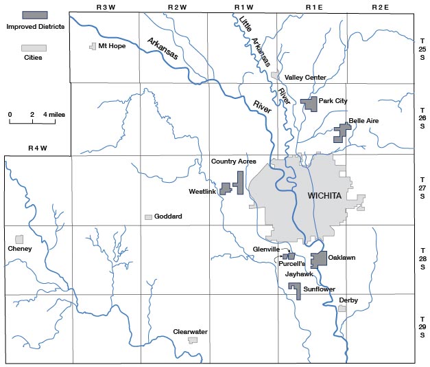
Eight cities and nine improvement districts in the County provide municipal water service for about 90 percent of the population. The location of the cities and improvement districts providing municipal water service and the areas served are shown on Figure 27. Table 12 gives data on each water system. The peak water demands experienced by these water systems are not shown on Table 12 but are commonly 2 to 3 times the average daily demand.
Table 12—Public water-supply systems in Sedgwick County, Kansas, 1960. Data obtained from publications of the Kansas State Department of Health, unpublished data from the Wichita-Sedgwick County Department of Health, and from interviews with city officials.
| City or improvement district | Source of water | Raw water pumping capacity (mgd) |
Raw water storage (millions of gallons) |
Water treatment | Capacity of treatment plant (mgd) |
Finished water storage (millions of gallons) |
Service pumping capacity (mgd) |
Average water use (thousands of gallons per day) |
Emergency power source |
Remarks | |||
|---|---|---|---|---|---|---|---|---|---|---|---|---|---|
| Ground | Elevated | Ground | Elevated | Annual | High Monthly | ||||||||
| Belle Aire Improvement District | 4 wells | 1.4 | N | N | C, Cg | N | N | 0.07 | 1.4 | 64.2 | 128.4 | N | |
| Chaney [sic] [Cheney] |
5 wells | 0.97 | N | N | C | N | N | 0.04 | 0.97 | 77.7 | 155.4 | G | One well equipped with gasoline engine for emergency use. |
| Clearwater | 4 wells | 0.97 | N | N | C | N | N | 0.06 | 0.97 | 85.8 | 175 | N | |
| County Acres Improvement District | 2 wells | 1.2 | N | N | C | N | N | 0.05 | 1.2 | 177 | 408 | N | |
| Derby (El Paso) | 5 wells | 2.4 | N | N | C, Cg | N | 0.50 | 0.10 | 1.7 | 349.3 | 506.5 | N | |
| Glenville Improvement District | 2 wells | 1.2 | N | N | I, C, S, F | 0.63 | 0.02 | 0.10 | 0.72 | 132.3 | 264.6 | N | |
| Goddard | 2 wells | 0.14 | N | N | C | N | N | 0.05 | 0.14 | 22.3 | 32.1 | N | |
| Hayesville | 3 wells | 1.8 | N | N | H, I, Al, L, Sa, M, R, S, R, C, F |
1.4 | 0.62 | 0.10 | 0.94 | 295.4 | 437.2 | N | |
| Jayhawk Improvement District | 3 wells | 1.1 | N | N | C,Cg | N | N | N | 1.1 | 112.4 | 258.5 | N | |
| Mt. Hope | 4 wells | 0.94 | N | N | C | N | N | 0.05 | 0.94 | 52.2 | 120.1 | N | One pump equipped with power takeoff for direct drive by auxiliary engine |
| Oaklawn Improvement District | 12 wells | 1.7 | N | N | C, Cg | N | N | 0.05 | 1.7 | 245.5 | 368.3 | N | |
| Park City Improvement District | 4 wells | 1.0 | N | N | C, Cg | N | 0.40 | 0.05 | 1.4 | 200 | 400 | N | |
| Purcells 1st Improvement District | 2 wells | 0.72 | N | N | C, Cg | N | N | 0.05 | 0.72 | 60.2 | 126.4 | N | |
| Sunflower Improvement District | 2 wells | 0.58 | N | N | C, Cg | N | N | N | 0.58 | 43.7 | 65.6 | N | |
| Valley Center | 3 wells | 1.5 | N | N | C, Cg | N | N | 0.28 | 1.5 | 173.9 | 316.5 | E | 300 kw generator for emergency use |
| Westlink Improvement District | 4 wells | 1.8 | N | N | C | N | N | 0.10 | 1.8 | 337 | 674 | N | |
| Wichita | |||||||||||||
| (Equus beds field) | 55 wells | 55.0 | 35.0 | N | H, A, Is, L, N, C, M, S, C, F, Cg |
112.0 | 14.8 | 2.30 | 95.0 | 26,500 | 35,500 | D, Ng, E | Raw water storage includes a 3 million gallon surface tank and the capacity of the transmission lines and treatment basins. Emergency power sources could distribute about 30 mgd. No emergency power for wells is available. |
| (Bentley reserve field) | 6 wells | 10.0 | N | ||||||||||
| (Local well field) | 27 wells | 30.0 | N | N | |||||||||
Raw water pumping capacity: Capacity given in table is a total for all wells and pumping equipment and in many cases exceeds the capacity of transmission lines.
Raw water storage: N = none.
Water treatment: Type of treatment plant: H = softening; I = iron and manganese removal; P = purification.
Treatment device: A = aeration; Al = alum; C = chlorination; Cg = polyphosphate; F = filter; Is = iron salts; L = lime; M = mixing; Nh = ammoniation; R = recarbonation; S = sedimentation; Sa = soda ash; T = taste and odor control.
Capacity of treatment plant: N = no treatment plant; where chlorination and polyphosphate addition are the only treatment these reagents are commonly added automatically at the well pump.
Finished water storage: N = none.
Emergency power source: D = diesel engine; DE = diesel electric; E = portable motor generator; G = gasoline engine; N = none; Ng = natural gas.
Figure 27—Map of Sedgwick County, Kansas, showing cities and improvement districts providing municipal water service.
The water-supply system for Wichita is the largest in the State and is quite complex, but it is very flexible in operation. The system is supplied by three well fields located in Sedgwick and Harvey counties. The location of the well fields and the principal pipelines connecting the system are shown on Figures 28 and 29. The 55 wells in the "Equus beds" well field (includes 36 wells in adjacent Harvey County), the 6 wells in the "Bentley reserve" well field, and the 27 wells in the "local" well field have a maximum combined yield of about 95 million gallons per day (mgd). The "Equus beds" well field is the principal source of water and is capable of yielding 55 mgd. The "Bentley reserve" well field, capable of yielding 10 mgd, and the "local" well field, capable of yielding 30 mgd, are used mainly to meet peak demands.
Figure 28—Map showing location of Wichita "Equus-beds" and "Bentley reserve" well fields and pipelines from these fields. (Well-field names are those used by the Wichita Water Department.)
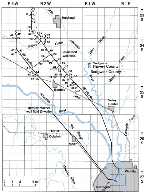
Figure 29—Map showing location of Wichita "local" well field.
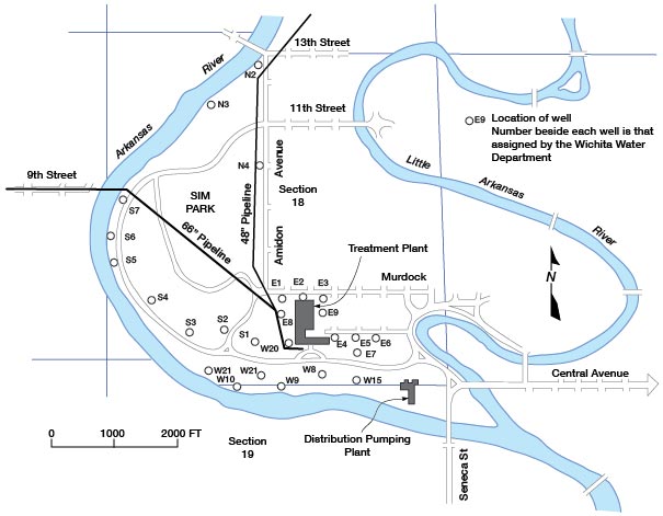
Water from the "Equus beds" and "Bentley reserve" well fields is delivered to the treatment plant through 66-inch and 48-inch pipelines. These pipelines are cross-connected and are about 25 miles in length. The combined capacity of these pipelines is about 100 mgd. Water that is stored in a 3-million gallon surge tank in the "Equus beds" well field and in the pipelines and treatment basins would provide about 2 days water supply for the city.
Wichita in cooperation with the U. S. Bureau of Reclamation began construction in 1962 of a dam on the North Fork Ninnescah River to impound water mainly as a supplemental water supply for the city. The dam is located in sec. 6, T 27 S, R 4 W, about 25 miles west of the water treatment plant. A 60-inch pipeline will deliver the water to the plant for treatment and distribution. When completed the reservoir will have a firm yield of 38 mgd.
Industrial Supplies
Sedgwick County is the most heavily industrialized area of the State, and industry is the greatest single user of water. Water demand by industries does not fluctuate as greatly as that for public supply and irrigation.
Water use by industry is believed to be about 53,000 acre-feet per year. Of this quantity, about 45,300 acre-feet is self-supplied and from 7 to 8 thousand acre-feet is supplied by the Wichita water system to industries located in the city. The water supplied to industry by the city is about 25 percent of the water produced by the city system. The largest use of water by industry is for power generation (steam boilers) and in all cases recirculation of the water is practiced. Wichita could supply an additional 30 mgd to industry in excess of peak demands on the city water system.
Irrigation Supplies
Irrigation with ground water has been practiced to a limited extent in Sedgwick County for many years, mostly as supplemental irrigation to provide needed water for crops during growth periods. The drought years from 1952 through 1956 caused a rapid expansion of irrigation in the County. Most irrigation remains supplemental in nature and results in a large fluctuation from year to year in the use of ground water for this purpose. Records of pumpage for irrigation are very sparse, but water rights have been approved or are pending approval by the State (1960) for 30,200 acre-feet of ground water to irrigate about 15,000 acres. Irrigation by flooding and by sprinkler methods are both practiced, the method used being determined by the topography and by the quantity of water available in the area to be irrigated.
Rural Domestic Supplies
Most rural domestic and stock water supplies in Sedgwick County are obtained from wells. Ponds are used in parts of the County to supply stock water, but most of the ponds that provide a perennial water supply are constructed on small spring-fed streams or have been excavated below the water table. The amount of ground water used for rural domestic supplies is not known but is estimated to be about 5,500 acre-feet per year. About 2,500 acre-feet of the total is from private wells in Wichita that are used principally for lawn and garden irrigation, but which are also used to some extent for domestic supply. Ground water is generally available in quantities adequate for domestic supplies in all parts of the County, and in those areas where the water is obtained from bedrock, the quality is commonly poor, but the water is usable.
Development of Additional Large Ground-Water Supplies
Additional large ground water supplies of from one to several million gallons per day for municipal, industrial, or irrigation use could be developed in parts of Sedgwick County. However, where a large-scale development is contemplated, consideration should be given to existing water rights and the availability of ground water as determined by the permeability and thickness of the water-bearing deposits. Figure 30 shows the volume of existing ground water rights in the County by townships and the areas considered most favorable for developing wells yielding 500 gpm or more without unduly affecting existing water supplies. In outlining the favorable areas as shown on Figure 19, consideration was given to existing water rights and the transmissibility of the water-bearing deposits. The areas in and adjacent to T 25 S, R 3 W, T 26 S, R 1 W, and T 27 S, R 1 W, are the most favorable for development of large water supplies. South of Wichita, in T 28 S, R 1 W, and T 29 S, R 1 E, the water-bearing deposits thin and extensive development of large water supplies might lower water levels, thus causing a decline in well yields.
Figure 30—Outline map of Sedgwick County, Kansas, showing volume of existing (1960) ground-water rights in acre feet by township, and areas favorable for developing additional large ground-water supplies.
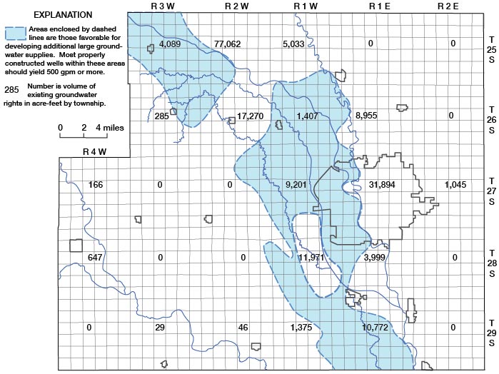
Large quantities of ground water could be developed by inducing infiltration of water from the Arkansas, Little Arkansas, and Ninnescah rivers with wells located adjacent to the river channels. Water thus derived from the Arkansas River would be inferior in quality for many uses, but it might serve as cooling water.
Prev Page--Chemical Character || Next Page--Wells and Springs
Kansas Geological Survey, Geology
Placed on web Nov. 1998; originally published Dec. 1965.
Comments to webadmin@kgs.ku.edu
The URL for this page is http://www.kgs.ku.edu/General/Geology/Sedgwick/gw08.html