![]()
Prev Page—Geography || Next Page—Ground Water
General Geology
Summary of Stratigraphy
(This report is a cooperative product of the U.S. Geological Survey and the State Geological Survey of Kansas. The classification and nomenclature of the rock units accord for the most part with those of the two surveys but differ somewhat from those of the U.S. Geological Survey.)
The rocks that crop out in Reno County are of sedimentary origin and range in age from Paleozoic to Cenozoic (P1. 1). The oldest rocks that crop out in the county are a part of the Ninnescah shale of the Leonardian Series, Permian System. The Ninnescah shale crops out in the northeastern and southeastern parts of the county and along the valley of the Ninnescah River in the southern part of the county where the river has cut through younger deposits. The Stone Corral dolomite crops out in northern Reno County and along the Ninnescah River valley in south-central Reno County. The youngest rocks of Permian age exposed in the county are rocks classified as the Harper sandstone, which crop out along the valley of Ninnescah River west of the outcrop of the Stone Corral dolomite. Cenozoic deposits of the Pleistocene Series ranging in age from the Blanco formation of the Nebraskan glacial stage to Recent alluvium unconformably overlie the Permian rocks over most of Reno County. These include unconsolidated deposits of sand and gravel in both the valleys and most of the upland area, and eolian silt occurring principally in the upland area. Information on the unexposed rocks that lie beneath the surface in Reno County has been obtained from test holes and from logs of oil wells drilled in the county.
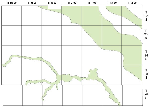
A generalized section of the rocks cropping out in Reno County is given in Table 2. The configuration of the pre-Pleistocene surface and the locations of the test holes in the county are shown in Figure 7, and the geologic cross sections based on these test holes are shown in Plate 3.
Figure 7—Configuration of bedrock surface and location of test holes.
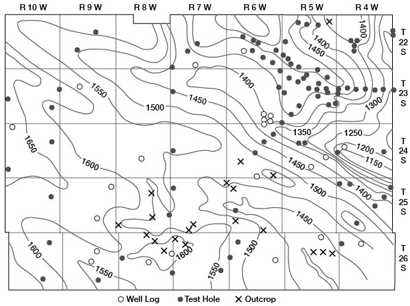
Table 2—Generalized section of the geologic formations of Reno County, Kansas (the stratigraphic nomenclature is that of the State Geological Survey of Kansas).
| System | Series | Subdivision | Thickness | Physical character | Water supply | ||
|---|---|---|---|---|---|---|---|
| Stage | Formation | Member | |||||
| Quaternary | Pleistocene | Recent | Alluvium | 0-60 | Silt, sand, and gravel in stream valleys | Yields large supplies of water of poor quality to many wells | |
| Dune sand | 0-120 | Medium and fine sand in upland areas | Yields small supplies of water of good quality to wells | ||||
| Wisconsinan | Sanborn | Peoria silt | 0-15 | Eolian silt | Lies above water table; yields no water to wells | ||
| Wisconsinan terrace deposits | 0-130 | Silt, sand, and gravel | Yields large supplies of water of good quality to wells | ||||
| Illinoian | Loveland Silt | 0-15 | Eolian and water-laid silt | Lies above water table; yields no water to wells | |||
| Crete sand and gravel | 0-40 | Silt, sand, and gravel | Lies in part above the water table; yields moderate supplies of water of good quality to wells where below water table | ||||
| Kansan | Meade | Sappa silt | 0-40 | Silt and very fine sand; contains Pearlette volcanic ash lentil | Lies above water table in part of area; yields little or no water to wells in area | ||
| Grand Island sand and gravel | 0-100 | Sand and gravel and minor amounts of silt | Yields large supplies of water of good to fair quality to many wells | ||||
| Nebraskan | Blanco | Fullerton silt | 0-30 | Silt and clay and minor amounts of sand | Yields no water to wells in area | ||
| Holdrege sand and gravel | 0-110 | Sand and gravel and minor amounts of silt and clay | Yields moderate supplies of water of good quality to wells in upland areas where present. Water highly mineralized in channel areas | ||||
| Permian | Leonardian | Harper sandstone | 0-200 | Red siltstone and very silty sandstone | Yields small supplies of highly mineralized water to wells in area of outcrop | ||
| Stone Corral dolomite | 0-20 | White and light-gray anhydrite and dolomite | Yields no water to wells in area | ||||
| Ninnescah shale | 0-300 | Red and green-gray shale, siltstone, and very fine silty sandstone | Yields small supplies of highly mineralized water in area of outcrop | ||||
| Wellington formation | 0-700 | Gray to blue-gray shale and thin interbedded calcareous zones; contains thick Hutchinson salt member | Yields no water to wells in area | ||||
Geologic History
Paleozoic Era
Over the basement igneous and metamorphic rocks were deposited marine rocks of Paleozoic (Cambrian and Ordovician) age. Silurian and Devonian rocks were probably deposited over the area and later removed by erosion after the pre-Mississippian uplift of the Ellis arch, known also as the Central Kansas arch. This ancestral arch extended from Chautauqua County northwestward through Ellis County. Rocks of Mississippian age were deposited over the arch and lie unconformably on the Cambro-Ordovician rocks. Post-Mississippian folding raised these rocks in Reno County, and parts of the upper Mississippian strata were eroded. Subsequent to this erosional period the area was submerged again and Pennsylvanian and Permian rocks totaling about 3,500 feet in thickness were deposited. After the deposition of the Permian rocks there was another long period of erosion.
Mesozoic Era
The Mesozoic Era in Kansas is represented by rocks of the Triassic, Jurassic, and Cretaceous systems. Reno County was probably a part of the land area during Triassic and Jurassic time; deposition in the county was renewed during Cretaceous time. No Cretaceous rocks crop out or were penetrated in the test drilling, but these rocks are present only a few miles west in Stafford County and to the north in Rice County. A considerable thickness of Cretaceous rocks probably was deposited in Reno County and later removed by erosion during early Tertiary time.
Cenozoic Era
Reno County was probably subjected to erosion during most of Tertiary time. No Tertiary deposits were found in the county during this investigation, but Ogallala rocks have been identified in Rice County. Thin deposits of the Ogallala formation probably were laid down in Reno County and later removed by erosion. In late Tertiary time Reno County was an area of low relief, but renewed erosion in early Pleistocene time dissected the land surface and cut deep valleys into the Permian beds. These valleys were later filled with alluvial deposits. Four major periods of erosion and deposition in the Pleistocene are evident in the county. Climatic changes during the four major glacial epochs effected the four major periods of erosion and deposition in Reno County.
History of Drainage
At the close of the Tertiary the surface of Reno County was an area of low relief. During the Nebraskan stage of Pleistocene time, streams traversing the county increased their rate of cutting and deepened their channels. The maximum relief in the county at the close of this cutting was about 160 feet.
Three main early Nebraskan valleys enter Reno County. One channel enters southwestern Reno County near the center of the west line of Township 26 South and extends eastward along this tier of townships nearly two-thirds the distance across the county. A second channel enters the county near the northwest corner and extends eastward about halfway across the county, where it is joined by the third--the Chase channel (Fent, 1950). From this junction the main channel trends southeastward and leaves the county near the center of the east county line.
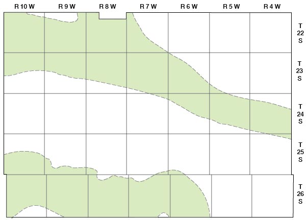
After the period of valley cutting in Nebraskan time, a period of valley filling took place. The deposits, the Blanco formation of the Nebraskan stage, range in thickness from a few feet along the flanks of the valleys to more than 100 feet in the channel entering the county at the northwestern corner. Figure 8 shows the areas in Reno County in which the Blanco formation of the Nebraskan stage crops out or is buried in the subsurface.
Figure 8—Map of Reno County showing areas in which Blanco formation crops out or is buried in the subsurface.
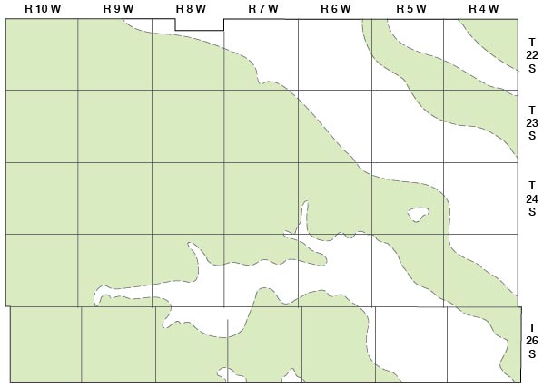
During the Kansan stage of Pleistocene time, the streams eroded laterally and the downcutting was less than that during the Nebraskan stage. A part of the Blanco formation of the Nebraskan stage was removed in the downcutting interval of the Kansan stage; the channels were then refilled with deposits of the Meade formation of the Kansan stage. As the channels of these streams became filled they shifted laterally. Figure 9 shows the areas in Reno County in which the Meade formation of Kansan age crops out or is buried in the subsurface. At the close of the Kansan stage of Pleistocene time the entire area of the county probably was mantled by the Meade formation. From the blank areas shown in Figure 9, it was removed later by erosion.
Figure 9—Map of Reno County showing areas in which Meade formation crops out or is buried in the subsurface.
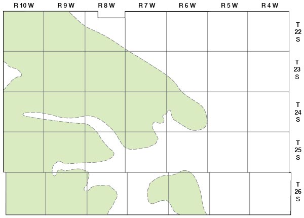
During the early part of the Illinoian stage of Pleistocene time there was another cycle of downcutting and deposition in the county. The downcutting was much less extensive than that during the Kansan stage. Deposition followed approximately the same pattern as in the Kansan stage, although these deposits are generally thinner than the Meade deposits of Kansan age. The early Illinoian deposits comprise the Crete sand and gravel member of the Sanborn formation. The areal distribution of the Crete sand and gravel member in Reno County is shown in Figure 10. The Crete sand and gravel member of the Sanborn formation probably was deposited over most of the county, but later Pleistocene erosion removed the member in the present major stream valleys.
Figure 10—Map of Reno County showing areas in which Crete member of Sanborn formation crops out or is buried in the subsurface.
After early Illinoian time the streams were more or less stable and the upland areas were covered by eolian deposits. The streams remained stable until the Wisconsinan stage of Pleistocene time, when the major streams, which by then were in approximately their present locations, became more active.
Late Wisconsinan downcutting by the streams removed the Crete sand and gravel member of the Illinoian stage and the Meade formation from the valleys; subsequent filling produced younger Wisconsinan terrace deposits. In the Ninnescah River valley the stream cut into Permian rocks as much as 100 feet below the base of the Meade formation. Since the deposition of the Late Wisconsinan terrace deposits the streams have remained in the same channels, and stream activity has consisted of minor downcutting and filling. Prominent low terraces in the valleys of the major streams are remnants of the Wisconsinan surface. The present Arkansas River has a braided channel. The channel becomes choked with sand and gravel during times of flood, and in low-water stages the stream flows through, rather than over, the pervious material making up much of the stream bed. The Ninnescah River, in a part of its course, and its tributaries are eroding their channels fairly rapidly, as indicated by the relatively rugged topography bordering these streams. Figure 11 shows the areas in Reno County in which Wisconsinan and Recent alluvial deposits are found.
Figure 11—Map of Reno County showing areas in which Wisconsinan and Recent alluvial deposits are exposed.
Prev Page—Geography || Next Page—Ground Water
Kansas Geological Survey, Geology
Comments to webadmin@kgs.ku.edu
Web version Feb. 2001. Original publication date Aug. 1956.
URL=http://www.kgs.ku.edu/General/Geology/Reno/geol01.html