![]()
Prev Page—Introduction || Next Page—General Geology
Geography
Topography and Drainage
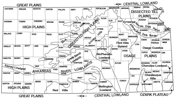
Reno County is in the Great Bend lowland physiographic division as designated by Adams (1903), except for a small area in the southwest part of the county that is in the High Plains section of the Great Plains province and a small area in the south-central part of the county that is in the Red Hills division (Fig. 3). The Great Bend lowland division is nearly flat in most places but in some areas has slight relief. The belt of sand dunes along the north side of the Arkansas River valley, the sand dunes in the west part of the county, and the area underlain by the Ninnescah shale adjacent to Ninnescah River provide the only prominent relief.
Figure 3—Map showing physiographic provinces in Kansas.
The highest points in the county are in the sand dunes in the western part of the county. The altitude of some of the points in the sand dunes is about 1,800 feet above sea level. The lowest points in the county are about 1,380 feet above sea level and occur along the Arkansas River and Ninnescah River where they leave the county.
Reno County is drained by the Arkansas River and its tributaries. The south part of the county is drained by the North Fork of the Ninnescah River, which joins the Arkansas River in eastern Sumner County near Oxford. The northeast part of the county is drained by the Little Arkansas River, which joins the Arkansas River in Sedgwick County at Wichita. The major tributaries to the Ninnescah River are Silver Creek, Goose Creek, and Red Rock Creek. The major tributaries of the Arkansas River in Reno County are Cow Creek, Salt Creek, and Peace Creek.
Climate
The climate of Reno County is subhumid and is characterized by moderate precipitation, a wide range of temperature, and moderately high average wind velocity. The summer days and many of the nights are generally hot. The winters are moderately cold, but are generally free from excessive snowfall.
The climatic data in this report are compiled from the records of the U. S. Weather Bureau. The normal monthly mean temperatures at Hutchinson range from a low in January of 31°F to a high in July of 80.2°F. The annual mean temperature is 56.1°F. The highest temperature recorded was 116°F on July 31, 1934; the lowest temperature recorded was -27°F on February 13, 1905. The average date of the last killing frost in the spring is April 17, and the average date of the first killing frost in the fall is October 18. Thus the average growing season is 184 days. Killing frosts have occurred as late as May 15 and as early as September 20, however. The longest growing season recorded was 223 days and the shortest was 145 days.
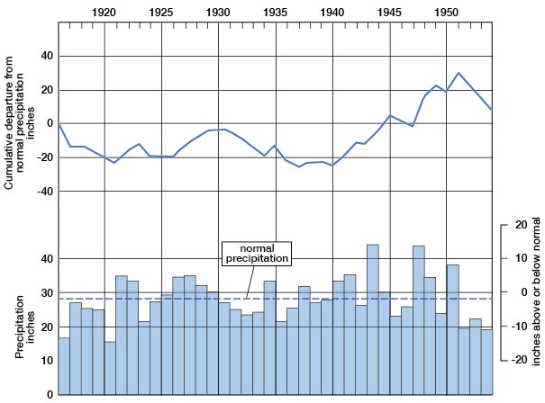
The normal annual precipitation at Hutchinson based on a 56-year record is 28.53 inches; the normal at Medora is 28.61. The lowest annual precipitation at Hutchinson was 15.40 inches in 1952 and the highest annual precipitation at Hutchinson was 46.97 inches in 1944. The annual precipitation at Hutchinson and the cumulative departure from normal are shown graphically in Figure 4. Data for Medora are shown in Figure 5.
Figure 4—Annual precipitation and cumulative departure from normal precipitation at Hutchinson.
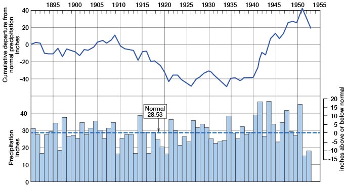
Figure 5—Annual precipitation and cumulative departure from normal precipitation at Medora.
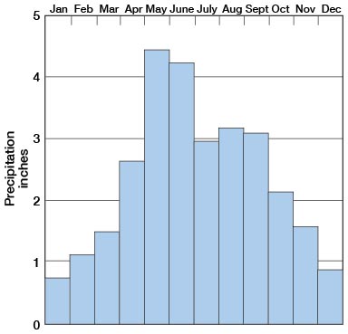
Precipitation in Reno County seems to follow irregular cycles in which periods of excessive rainfall are followed by periods of deficient rainfall. About 70 percent of the annual precipitation falls as rain during the growing season from April to September. January has the lowest normal monthly precipitation, 0.72 inch, and May has the highest normal monthly precipitation, 4.45 inches (Fig. 6). Much of the precipitation in Reno County falls in heavy rains; many of these storms are followed by periods of deficient rainfall. The greatest rainfall in a day recorded at Hutchinson was 4.75 inches on July 4, 1895.
Figure 6—Monthly distribution of precipitation at Hutchinson.
Population
Reno County was organized in 1872. In 1950 the county had a population of 54,058 and ranked fourth in the state in population. Hutchinson, the largest city and the county seat, had a population of 33,575. Other communities and their 1950 populations are South Hutchinson, 1,045; Nickerson, 1,013; Buhler, 750; Haven, 720; Turon, 632; Sylvia, 496; Pretty Prairie, 484; Arlington, 405; Partridge, 221; Plevna, 200; Langdon, 120; and Abbyville, 99.
Transportation
Reno County is served by the main lines of the Atchison, Topeka, and Santa Fe Railway Company and the Chicago, Rock Island and Pacific Railway, and by branch lines of the Missouri Pacific Railroad Company and the St. Louis and San Francisco Railroad. Each of the communities named above is served by one or more of these lines.
Improved State and Federal highways in Reno County amount to about 152 miles. U.S. Highway 50S crosses the county east to west; Kansas Highway 61 crosses the county from northeast to southwest; Kansas Highway 17 crosses the eastern part of the county from north to south; and Kansas Highway 14 crosses the county from north to south through the center of the county. These highways are hard surfaced. County and township roads are in good condition most of the year, and roads on most of the section lines are open except in parts of the sand-dune areas.
Agriculture
Reno County has 3,058 farms. According to the State Board of Agriculture, a total of 510,481 acres was under cultivation in 1950. The acreage of all principal crops grown in 1950 is shown in Table 1.
Table 1—Acreage of principal crops grown in Reno County in 1950.
| Crop | Acreage |
|---|---|
| Wheat | 362,000 |
| Sorghums | 82,120 |
| Hay | 31,170 |
| Barley | 16,200 |
| Oats | 14,200 |
| Corn | 7,800 |
| Rye | 2,820 |
Mineral Resources
Mineral resources of Reno County include oil, gas, salt, sand, gravel, and volcanic ash.
Oil and Gas
Reno County is among the most important oil-producing counties in the state. As early as 1878 test wells were drilled in the vicinity of Hutchinson, but these wells were less than a thousand feet deep and did not produce oil or gas. The first well in the county to produce oil was completed in January 1927 in what is now the Abbyville pool. This well initially produced 325 barrels a day from the Kansas City group of Pennsylvanian age. In 1956, Reno County has 16 producing fields. Producing zones in Reno County are the Lansing-Kansas City group, Mississippian "chat", Hunton formation, and Viola limestone. The cumulative production, the number of wells, the producing zones, and the depth of production for all fields are detailed in the annual reports of the Geological Survey of Kansas on oil and gas developments.
Salt
The salt deposits of the Wellington formation in Reno County were discovered during drilling for oil and gas in the vicinity of Hutchinson in 1887. These deposits of salt were laid down in Permian seas that probably were partly cut off from the ocean. The beds extend eastward from a line between eastern Gove County and eastern Seward County to a line extended along the east line of Reno County. The eastern edge of the salt beds is only a few miles west of the outcrop of the Wellington shales. The salt beds originally extended farther east but were removed by circulating ground water. North and east of the present limits of the salt beds in the vicinity of Hutchinson the Wellington formation thins, and the removal of salt by circulating ground water has caused slumping.
Near Hutchinson the salt beds, interstratified with some thinner shale beds, are as much as 450 feet thick (Taft, 1946). Jewett (Jewett and Schoewe, 1952) estimated the salt reserves of Kansas to be about 5,000 billion tons.
Kansas ranks sixth in the United States in production of salt, and Reno County produces about 75 percent of the salt mined in Kansas. Three of the five plants producing salt in Kansas are in Reno County at Hutchinson. One shaft mine 650 feet deep produces salt used mainly for stock and industrial purposes. Salt is also obtained at two plants by evaporation of brines formed by pumping water down through wells and this salt is refined for use in meat-packing plants and other establishments that prepare foods.
Sand and Gravel--Sand and gravel are obtained in Reno County from Pleistocene deposits in the Arkansas River valley. The gravel and sand are used for road surfacing and for concrete aggregate.
Volcanic Ash
Volcanic ash is mined from two pits in Reno County. One pit was opened in 1948 in the SE NE sec. 1, T. 25 S., R. 7 W. The other pit, which likewise has been worked for several years, is situated in the center of sec. 14, T. 25 S., R. 8 W. The ash is used by the county road department as a component in road-surfacing material.
Prev Page—Introduction || Next Page—General Geology
Kansas Geological Survey, Geology
Comments to webadmin@kgs.ku.edu
Web version Feb. 2001. Original publication date Aug. 1956.
URL=http://www.kgs.ku.edu/General/Geology/Reno/geog01.html