![]()
Prev Page--Introduction || Next Page--Geology
Geography
Physiography
Ottawa County lies within the Interior Plains physiographic unit (Fenneman, 1931). The physiographic subdivisions coincide with areas of outcrop of some of the major stratigraphic units. The Permian rocks in the southeast corner of the county are assigned to the Osage Plains of the Central Lowland. The Permian portion of the Osage Plains was further assigned by Schoewe (1949) to the Flint Hills Upland subdivision. The rest of the county lies within the Plains Border of the Great Plains province and is composed of rocks of Cretaceous age. The Plains Border was further subdivided by Schoewe and that part of it in Ottawa County assigned to the Dissected High Plains, which is composed of the Smoky Hills and the Blue Hills.
The Smoky Hills are the psysiographic expression of Kiowa Shale and Dakota Formation in most of the county. The Blue Hills in the northwest corner of the county are composed of rocks of Cretaceous age that are younger than the Dakota Formation. The Graneros Shale is less resistant than the overlying Greenhorn Limestone, which caps a westward-dipping cuesta, the Blue Hills, bounded on the east by a bold escarpment. Gently inclined Permian rocks, though poorly exposed, form a dissected plain. Sharp differences in relief are minimized by eolian deposits on most of the bedrock.
Rocks of Cretaceous age, especially the Dakota Formation, generally have a much bolder topographic expression than rocks of Permian age, although the Kiowa Shale is physiographically inconspicuous in Ottawa County. Thin sand zones in the Dakota Formation, generally less than 2 feet thick and firmly cemented by iron oxides, form resistant caps on many hills, resulting in a rugged, dissected, eastward-facing series of escarpments having relief as much as 300 feet, especially in the northeastern, south-central, and western parts of the county. The uppermost and lowermost parts of the Dakota Formation contain most of the sand; the middle part contains mostly silt and clay, hence produces a gently rolling land surface along the strike from the north-central part of the county toward the southwest.
Drainiage
Solomon River enters the county about 6 miles east of the northwest corner, trends to the south and east, and leaves the county about 5 miles west of the southeast corner. Solomon River flows perennially, but it is joined by several intermittent tributaries within the county. Largest of these is Salt Creek, which flows eastward from Mitchell and Lincoln counties and joins Solomon River about 3 miles south of Minneapolis. Pipe and Lindsey Creeks flow southward from the north-central part of the county and are confluent with Solomon River north and south of Minneapolis respectively. Limestone Creek drains from hills in the northwestern part of the county southeastward to Solomon River. Sand and Coal Creeks are the only other major tributaries of Solomon River; both flow southward into the southeastern part of the county.
In the northeastern part of the county, Chapman and West Chapman Creeks flow southeastward into Clay County. South of the divide in the southwestern part of the county, all drainage is to Saline River, the only other stream in Ottawa County that flows perennially.
Climate
Ottawa County is in a subhumid belt that varies from semiarid to humid. Much of the following climatic discussion is adapted from Robb (1941) and Flora (1948). Temperature extremes at Minneapolis have ranged from -29°F in February 1899 to 119°F in August 1936. The average January temperature is 29°F, and the average July temperature is 80°F. The annual mean temperature is 56.4°F. The average date of the first killing frost is October 15 and that of the last is April 22. The growing season averages 176 days, and average warm-season (April to September, inclusive) precipitation is about 20 inches. The annual mean precipitation at Minneapolis is 26.62 inches. During the period of record from 1893 to 1945, precipitation was 0.01 inch or more for an average of 80 days annually, 0.25 inch or more for 30 days, and 1.00 inch or more for 6 days. Precipitation is discussed further in the section on hydrology.
Population
After the organization of Ottawa County in 1866, the population increased greatly and then declined gradually for many years. Available records, beginning in 1878, show a large increase in population for 12 years when settlers were moving west after the Civil War (Fig. 2). The population decreased more than 20 percent in 1890 because of a nearly complete crop failure, the last of a series of failures starting in 1887 (Kansas State Board of Agriculture, 1893). Population increased slowly from 1896 until 1901, when another drought caused farmers to leave the county. This decline in population was minor compared to that of the previous decade. Rural population increased generally after 1901 until World War I. The major industrial expansion in other states after World War I caused the population in Ottawa County to decline until the early thirties, when the economic depression reduced the opportunity for industrial employment. The population remained relatively constant until World War II, but thereafter until 1958 the rural population declined almost continuously but at a decreasing rate. The population of Ottawa County in 1958 was at its lowest point since 1878. The rate of decline indicates a slow decrease in rural population in the future. [Note: Ottawa County population was listed as 6,163 in 2000 U.S. census, with a density of 8.5 (32.9 for the state) (KU Institute for Policy & Social Research).]
Figure 2--Population trends in Ottawa County, 1878-1958.
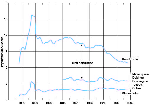
The city of Minneapolis has had a relatively stable population. The trends suggest fluctuation of rural population only. Both urban and rural population increased during the depression, and the rate of decrease since that time has been much greater in rural areas. [Minneapolis had a population of 2,046 in 2000.]
Agriculture
Farming is the most important segment of Ottawa County's economy and includes both stock raising and cash crops. In 1958 the county had 27,600 cattle of all types. Although the number of farms decreased almost steadily from 1,465 farms in 1941 to 945 farms in 1958, the number of farm acres has increased from 385,063 to 404,420 during the same period. Acreage of crops planted for harvest in 1958 is shown in Table 1.
Table 1--Acreage of crops planted in Ottawa County in 1958.
| Crop | Acres |
|---|---|
| Winter wheat | 108,074 |
| Oats | 9,309 |
| Corn | 7,095 |
| Winter barley | 6,520 |
| Rye | 5,396 |
In 1957, an area of only 98 acres was irrigated from wells and 508 acres from streams. During that year, available facilities would have permitted irrigation of 1,397 acres from wells and streams.
Mineral Resources
Sand and gravel for local use have been quarried from the higher terraces of Pleistocene age. Most of these terrace materials are poorly sorted and contain a large percentage of fine sand and silt. The deposits are small and are not suitable for large-scale commercial quarries. A report by Plummer and Romary (1947) on the clays in the Dakota Formation discusses locations, stratigraphic sections, and firing properties of clays in Ottawa County. Extensive deposits of kaolinitic refractory clays in the county are not produced commercially. Oil and gas are not produced in Ottawa County. Twenty wildcat wells in the county have been reported to the State Geological Survey. Surface mapping and geophysical exploration indicate structural highs, but wildcat wells have not produced oil. Shale suitable for making lightweight aggregate is present in usable quantities in the Kiowa and Graneros Shales (Plummer and Hladik, 1951), and clay suitable for making lightweight refractories is present in the Dakota Formation. The shale and clay have not been utilized commercially in the county.
Prev Page--Introduction || Next Page--Geology
Kansas Geological Survey, Geology
Placed on web March 23, 2009; originally published January, 1962.
Comments to webadmin@kgs.ku.edu
The URL for this page is http://www.kgs.ku.edu/General/Geology/Ottawa/03_geog.html