![]()
Prev Page--Permian || Next Page--Structural Geology
Stratigraphy of Outcropping Rocks, continued
Pennsylvanian System
Virgilian Series
Wabaunsee Group
Brownville Limestone
The Brownville limestone has an average thickness of about 2 feet. In fresh exposures it is a bluish-gray hard limestone in a single ledge or may have one or two thin partings. On weathering it becomes yellowish brown and the top surface is uneven. Typical fossils include Marginifera, Chonetes, bryozoans, crinoids, and fusulinids. Except for small supplies of water from shallow wells in the zone of weathering it is of little importance as an aquifer.
Pony Creek Shale
Measured sections of the Pony Creek shale range from 5 to 14 feet and average about 7 feet in thickness. It comprises gray to olive shale in the upper 3 feet which commonly is calcareous and, in the upper few inches, may be fossiliferous. Middle and lower parts are silty and sandy micaceous gray, green, and red shale. Locally a disconformity in the Pony Creek shale cuts out the upper part of the Caneyville limestone. It is of little importance as a source of ground water.
Caneyville Limestone
Two limestones and an unnamed separating shale comprise the Caneyville limestone. Where both the upper and lower limestones are recognizable the formation has a thickness of 12 to 14 feet. It is of little importance as an aquifer.
Grayhorse limestone member--The Grayhorse member is a gray to gray-brown in part silty to sandy and partly coarsely crystalline brown-weathering limestone. Thickness ranges from 0.3 to about 2 feet where the member is identified. Thicker sections comprise two thin limestones and a gray shale bed. Myalina and other pelecypods, bryozoans, and algae are the common fossils. Locally the member is not present because of nondeposition or because of removal by erosion during Pony Creek deposition.
Unnamed shale member--Middle Caneyville beds comprise about 10 or 11 feet of gray, green, and red silty and sandy shale and sandstone. As in areas to the northwest (Mudge and Burton, 1950) a disconformity originating in the Caneyville shale locally has cut out the Nebraska City limestone.
Nebraska City limestone member--In much of its outcrop area in Osage County the Nebraska City limestone member is absent. Where it can be identified it is represented by a limy micaceous sandstone about 1 foot thick containing fragments of brachiopods and bryozoans.
French Creek Shale
The average thickness of the French Creek shale is about 30 feet. Where the Nebraska City limestone is absent and the upper boundary is indeterminate, the interval from the base of the Grayhorse to top of the Jim Creek limestone is about 41 to 44 feet. The Lorton coal, ranging from a featheredge to 0.6 foot in thickness, occurs in the upper 10 feet of the formation (at a few places two coals are separated by sandstone and gray shale). Gray shaly micaceous sandstone and sandy shale which weathers olive to tan form the predominant part of this formation. Locally, black carbonized plant remains are abundant. At some places brown limonitic concretions occur in the lower part.
Small supplies of ground water of variable quality are obtained locally from sandy zones at shallow depth.
Jim Creek Limestone
The Jim Creek limestone is a gray or brown and gray fine-grained hard limestone which occurs in a single ledge 0.5 to 1 foot thick. The bed weathers shelly and in many exposures the top surface is red or purple brown from limonite or hematite stains. Fossils include Chonetes, Derbyia, Dictyoclostus, Enteletes, small productid brachiopods, gastropods, bryozoans, Allorisma, Nucula, Nuculana, and Myalina. Fusulinids were not observed in any sections measured. Locally joints are much enlarged by solution.
The Jim Creek limestone is of little importance as an aquifer.
Friedrich Shale
Gray, olive, and green clayey to silty shale beds averaging 10 to 15 feet in thickness comprise most of the Friedrich shale. The weathered shale is brown to yellowish with streaks of brown limonite nodules and stains on bedding planes. Fossils are rare or absent.
The formation supplies little or no water to wells in this area.
Grandhaven Limestone
The Grandhaven limestone averages about 9 feet in thickness and normally comprises two limestones separated by a few feet of shale.
The upper limestone is light-gray algal limestone which weathers light tan to nearly white. Abundant large Osagia algae locally give the rock the appearance of a pebble conglomerate. Clams, bryozoans, brachiopods, crinoids, and fusulinids are also numerous in some exposures. Everywhere it is observed it is less than 2 feet in thickness, and locally the algal bed may be thin or absent.
Underlying silty to clayey shale beds averaging 4 to 8 feet in thickness are gray or olive and locally contain a red zone.
The lower limestone ranges from about 1 to 3 feet in thickness and comprises gray to yellow-brown limestone which weathers yellow brown. Fusulinids, crinoids, bryozoans, and brachiopods are abundant in most outcrops.
The Grandhaven limestone is not an important source of ground water. Locally, however, small supplies may be obtained from it at shallow depths.
Dry Shale
The Dry Shale comprises 7 to 18 feet of gray, green, and tan silty and calcareous shale. A nodular zone of limestone interbedded with gray-green shale occurs near the middle in some exposures. Crinoid fragments and a few brachiopods occur locally in the shale or the nodular limestone but the formation is mostly unfossiliferous. It is unimportant as an aquifer.
Dover Limestone
Exposures of the Dover limestone range in thickness from 1.5 to about 4 feet and average about 3 feet. It is light gray, especially the upper part, to light tan and weathers light gray tan. Large algal growths of the Cryptozoon type are numerous in the upper few inches of the limestone and robust fusulinids are abundant in the remainder of the bed. Horn corals, brachiopods, Osagia, and crinoid remains are also found in less abundance. Frequently the outcrop of the Dover and the slopes below it are covered with fusulinids which have weathered free. Because of its position and thickness the Dover generally makes the most prominent bench occurring between the Brownville and Tarkio limestones. The Dover limestone is of little importance as a source of ground water.
Langdon Shale
Gray and olive-gray, tan-weathering, blocky to thin-bedded sandy shale and gray, tan-weathering shaly sandstone comprise the Langdon shale. The upper foot or two is calcareous to sandy shale which, in southern outcrops, may contain fusulinids near the top. In other exposures the upper several feet of Langdon shale is sandy micaceous shale and thin-bedded to massive micaceous sandstone, parts of which are cemented with calcite. Middle and lower parts are thin-bedded silty and sandy shale containing scattered plant remains and ferruginous concretions.
A few wells obtain small supplies of ground water from sandy parts of the Langdon shale at shallow depths.
Maple Hill Limestone
The Maple Hill is a thin, medium-gray, brownish-gray weathering, hard limestone. It occurs as a single ledge and because of its widely spaced joints weathers out in large rhomb-shaped blocks. The top surface weathers reddish purple and the iced becomes shelly in many exposures. Small fusulinids, bryozoans, crinoids, and brachiopods are the most common fossils.
The Maple Hill limestone is of little importance as an aquifer.
Pierson Point Shale
Exposures of the Pierson Point shale average about 24 to 28 feet, thickening southward. At the top of the formation is a persistent thin coal or very carbonaceous streak and a thin gray underclay, together 2 feet or less in thickness. Next below is 8 to 15 feet of gray or greenish-gray, clayey to sandy shale containing one to three thin limy fossiliferous zones, the lowermost of which can be observed in most outcrops of this formation across Osage and Lyon Counties. North of Osage County the Pierson Point shale thins and in exposures in the vicinity of Maple Hill none of the fossiliferous limy zones are recognizable although the upper part contains scattered fossils. The lowermost of these limy fossiliferous zones, the Stormont limestone (O'Connor, 1953, p. 19), is identifiable across Osage and Lyon Counties and persists south of the area where typical algal-fusulinid Tarkio pinches out. The Stormont limestone averages about 2 feet in thickness and is variable in lithology, ranging from a sandy limestone to a limy sandstone or nodular very impure siltstone but everywhere is fossiliferous. The fauna contained includes fusulinids, numerous mollusks, brachiopods, bryozoans, crinoids, large algae, and in some exposures an abundant microfauna. It is generally nonresistant to weathering and makes little or no bench on hillsides. Unfossiliferous shale beds averaging 10 to 15 feet in thickness, comprising sandy or silty micaceous gray or gray-green shale in the upper part and blocky to thin-bedded blue-gray shale in the lower part, occur between the Stormont limestone and the algal bed at the top of the Tarkio limestone.
The Pierson Point shale is not important as an aquifer.
Tarkio Limestone
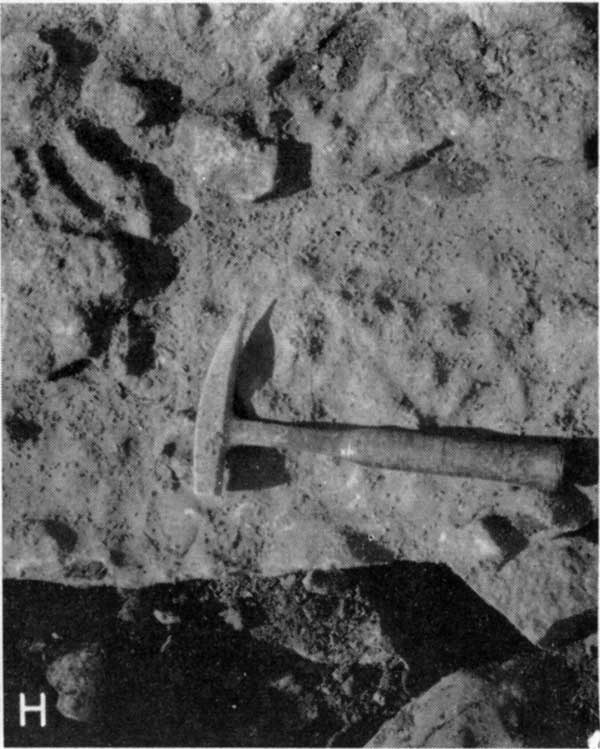
The Tarkio limestone ranges from about 7 feet in the north to a featheredge in the south, averaging 2 to 5 feet along most of its outcrop. It is a hard, massive, gray limestone which weathers a deep rich brown. Most of the bed contains an abundance of large fusulinids which weather into relief and are nearly white (Pl. 4H) in strong contrast to the brown-weathering matrix. The upper foot of limestone commonly contains abundant algae, mostly of the Cryptozoon type, but locally the algae are scattered through most of the formation. Crinoids, bryozoans, and brachiopods are present also. The Tarkio is unimportant as an aquifer.
Plate 4H--Tarkio limestone with large fusulinids weathering in relief.
Willard Shale
The Willard shale comprises 12 to 24 feet of gray to olive, silty, sandy, and clayey shale lying between the Tarkio and Elmont limestones. Locally it may contain thin zones of shaly sandstone. Fossils are not common but a few gastropods, pelecypods, and brachiopods are found locally in the upper part. In some places plant fragments occur in parts of the formation. Where the Tarkio limestone is absent in the south the Willard is included with the Pierson Point shale as the Pierson Point-Willard shale.
It is unimportant as an aquifer.
Elmont Limestone
The Elmont limestone ranges in thickness from about 1.5 to 7 feet. Typically it contains a thin molluscan or algal-molluscan limestone at the top separated by a few inches to 1 foot of gray calcareous shale. The next lower bed is a hard, dense, brittle, gray-blue limestone containing small inconspicuous fusulinids, Cryptozoon type algae of a slightly different color from the remainder of the bed, brachiopods, and crinoids. This bed is characterized by its close-spaced vertical joints. A thin conglomeratic limestone or zone of subrounded blue-gray pebbles marks the base of the Elmont limestone and is separated from the fusulinid bed by 1 to 4 feet of clayey and calcareous gray shale. The calcareous shale in several exposures contains Derbyia, Chonetes, and other brachiopods. The upper or lower limestone may be absent in some exposures.
The Elmont limestone is not an important source of ground water.
Harveyville Shale
Outcrops of the Harveyville shale range in thickness from about 2 to 10 feet. It is thin-bedded blue-gray to olive shale, which weathers tan. Locally it is slightly calcareous or sandy.
The Harveyville shale yields little or no water to wells.
Reading Limestone
The Reading limestone comprises one to three beds of limestone and a small amount of shale separating the limestones. It averages about 3 feet in thickness but is as much as 7 feet where shale partings between the limestones are prominent. The limestone is dark gray-blue, dense limestone which weathers yellow brown. The lower part contains abundant fusulinids as well as other fossils and at some places where a shale parting is present, two fusulinid bearing limestones. Fusulinids are absent from the upper part of the formation. Bryozoans, crinoid fragments, and brachiopods are numerous in all the limestone beds. The shale beds are thin-bedded, gray to tan, and calcareous.
The Reading limestone ordinarily yields little or no water to wells. A few wells obtain small supplies from joints and fractures at shallow depths.
Auburn Shale
Strata, chiefly shale, sandstone, and soft limestones averaging 45 to 50 feet in thickness comprise the Auburn shale. Outcrops of the Auburn shale along the Shawnee-Osage County line are chiefly sandstone and sandy shale whereas outcrops along the Lyon-Osage County line are chiefly shale and limestone with little or no sandstone.
Near the top of the Auburn shale in many exposures is 2 to 10 feet of limy sandstone, or limy sandstone interbedded with sandy olive to gray shale. The limy sandstone is fossiliferous, algae and mollusks predominating. Locally carbonized plant remains in calcareous to clayey gray shale occur between the base of the Reading limestone and the limy sandstone in the upper part of the Auburn shale. Middle and lower beds, where not sandy, may contain one or two sparsely fossiliferous thin siltstones or soft limestones.
The Auburn shale, especially in areas where considerable sandstone is present, yields small supplies of water of variable quality to wells.
Wakarusa Limestone
The Wakarusa limestone ranges from about 3 to 8 feet in thickness. It comprises massive, thick-to medium-bedded limestone containing a variety of fossils. Large fusulinids, Ottonosia, brachiopods, crinoids, corals, and bryozoans are common. In thick sections the upper part is rather sandy algal molluscan or unfossiliferous limestone and weathers thin- to medium-bedded. In fresh exposures this limestone is bluish gray or mottled gray and brown and becomes light to dark brown in color when weathered.
It supplies small quantities of ground water to a few shallow wells chiefly from joints and fractures.
Soldier Creek Shale
Gray to olive, yellow-tan weathering silty to clayey shale 2 to 7 feet thick comprises the Soldier Creek shale. Locally calcareous nodules occur in the shale and in one exposure about 0.4 foot of coal was observed. It is unfossiliferous except for carbonized plant remains.
It yields little or no ground water to wells.
Burlingame Limestone
Thickness, lithology, and fossil content of the Burlingame limestone differ greatly from one outcrop to another because of differences in development of various parts of this stratigraphic unit. Measured sections of this limestone range from about 2 to 9 feet and average about 3 feet in thickness. Most commonly this formation is characterized by one or more massive-bedded, light-gray and buff limestones in which the matrix weathers buff to brown and the fossils weather light gray or tan. Small fusulinids are found in many outcrops and Osagia algae are abundant nearly everywhere. Locally limestone containing mollusks and the brachiopods Juresania and Derbyia occur in the lower part; elsewhere light-gray, brecciated algal-molluscan limestone up to several feet in thickness occurs in the upper part. Quarries in this brecciated, cross-bedded algal molluscan phase occur on the hilltops about 2 miles northeast of Burlingame and 2 miles southwest of Osage City (Pl. 2). Locally the limestone is conglomeratic. Bryozoans, crinoids, and brachiopods are generally associated with the fusulinid and algal beds.
The Burlingame yields small supplies of water of generally good quality to a few shallow wells.
Silver Lake Shale
Measured sections of the Silver Lake shale range from about 30 to 38 feet and average perhaps 35 feet. It comprises blue-green, olive, and blue-gray clayey and sandy shale. Shale in the upper part may be calcareous or contain impure calcareous siltstones. Yellowish-brown weathering sandstone and sandy micaceous shale are present in the middle and lower parts in many exposures. A thin coal bed ranging from a featheredge to about 0.4 foot thick occurs locally near the middle of the shale and carbonized plant remains are abundant. Except for land plants it is generally unfossiliferous.
Sandy parts of the Silver Lake shale yield small amounts of water to shallow wells locally.
Rulo Limestone
The Rulo is a thin but distinctive limestone 1.5 to 2 feet thick. Its position below the scarp making Wakarusa and Burlingame limestones and above the persistent Elmo coal together with its distinguishing lithologic characters make it readily recognizable.
It is blue gray and weathers drab yellow brown to dark gray with a slight mottled and knobby appearance caused by slightly different weathering characteristics of the fossiliferous and non-fossiliferous parts of the limestone. It comprises a single massive limestone having relatively wide-spaced joints. Upon weathering it tends to become shelly and break into small chips. Fossils are numerous and include Dictyoclostus, Neospirifer, Derbyia, Myalina, Pinna, horn corals, crinoids, bryozoans, and algae.
The Rulo is not important as an aquifer.
Cedar Vale Shale
The persistent Elmo coal occurs in the upper part of the Cedar Vale shale, generally within 1 foot of the Rulo limestone. It ranges from 0.1 to 0.5 foot in thickness and is commonly underlain by 0.2 to 0.4 foot of gray underclay. Beds of yellow-brown weathering sandstone occur in the upper part below the coal and underclay in a few exposures; elsewhere the remainder of the formation comprises gray or olive-green silty to sandy micaceous shale. Thickness of the unit ranges from about 10 to 28 feet and averages about 25 feet.
It yields small supplies of water to a few shallow dug wells.
Happy Hollow Limestone
The Happy Hollow limestone occurs as a thin relatively unfossiliferous detrital limestone in some outcrops and as two or three thin impure sandy to shaly fossiliferous limestones in other outcrops. It is a poor bench maker and good exposures are difficult to find.
Where several thin limestones and separating shales comprise the formation it is 4 to 9 feet thick. Top and base are marked by soft, shaly, or sandy, tan to gray-green molluscan-brachiopod limestones. Middle beds comprise chiefly gray to greenish silty and calcareous shale and soft molluscan limestones. Fusulinids may occur in the upper middle part but are not present in all outcrops.
In outcrops represented by detrital beds of limestone the formation comprises 1 to 4 feet of tan to yellow-brown limestone and may contain Osagia, brachiopods, crinoids, and mollusks.
The Happy Hollow ordinarily yields little or no water to wells.
White Cloud Shale
Gray, olive, and tan shale and sandstone beds averaging about 80 feet in thickness occurring between the Happy Hollow and Howard limestones comprise the White Cloud shale. In the area north of Dragoon Creek a considerable part of the formation consists of fine to very fine, gray, brown-weathering sandstone. Land plant remains occur in the sandy parts and locally a thin coal occurs in the upper part. Marine fossils are sparse or absent.
The White Cloud formation yields small supplies of ground water from beds of sandstone to many stock and domestic wells in part of Osage County. In areas lacking sandy zones it is not an important aquifer.
Howard Limestone
Measured sections of the Howard limestone range from about 20 to 35 feet, the average thickness being about 25 feet. It supplies small amounts of ground water to a few shallow wells.
Utopia limestone member--The Utopia member consists of several limestones separated by thin shales. The upper bed, ranging from about 1 to 5 feet in thickness, is a light-to medium-gray "oatmeal"-textured limestone having abundant fusulinids and probably some algae in the upper part, grading downward into a limestone containing chiefly clams and snails. A thin gray calcareous shale ranging from a featheredge to 1.5 feet in thickness is underlain by 1.5 to 3 feet of thin unfossiliferous silty to fine sandy gray flaggy limestone.
According to Walter H. Schoewe (personal communication) these flaggy beds are the ones which contain abundant amphibian footprints, first noted by Mudge in 1873.
Below the flaggy beds 2 to 4 feet of thin-bedded fissile gray to dark-gray shale is present. Ostracods are abundant in parts of this shale. One or two thin impure limestones are present locally. The basal part of this member comprises 1.5 to 2.5 feet of blue-gray, light brown-gray weathering limestone containing abundant mollusks, especially Nuculana, Myalina, and several species of cephalopods.
Winzeler shale member--The Winzeler shale member averages about 3 feet in thickness. Locally, however, less than a foot of shale separates the Utopia and Church limestones. It comprises gray to tan shale locally with one or two thin limy stringers.
Church limestone member--The Church member averages 2 feet in thickness and occurs as a single massive bed of blue-gray, brown-weathering hard limestone. Crinoids, Cryptozoon algae, and brachiopods are the most common fossils but bryozoans and mollusks are abundant locally.
Aarde shale member--The average thickness of the Aarde shale member is 12 to 14 feet (area where Bachelor Creek member is identifiable). The upper part, above the Nodaway coal, is typically gray or blue-gray silty to calcareous shale underlain by dark-gray to nearly black fissile shale. Below the black fissile shale and above the Nodaway coal are 2 to 9 feet of gray clayey shale locally with a thin limestone similar in fauna and character to the Church limestone.
The Nodaway coal is a bituminous coal ranging in thickness from a featheredge to about 18 inches as observed in outcrops. Mine operators report as much as 36 inches of coal locally in mines (Schoewe, 1946, p. 24). Below the coal a thin sticky, structureless, gray underclay is present underlain by 1 to 4 feet of gray clayey and sandy shale. From the vicinity of Scranton northward the base of the Aarde is considered to be the base of the Nodaway coal as the Bachelor Creek limestone is not recognizable.
Bachelor Creek limestone member--The basal member of the Howard limestone is a hard very sandy, gray to blue-gray, gray-brown weathering limestone. It ranges from about 2 to 8 feet and averages about 5 or 6 feet in thickness. Fossils are not abundant but include mollusks, bryozoans, crinoids, and brachiopod remains. In outcrops in northern Osage County, it becomes unrecognizable, grading into sandy shale or sandstone.
Severy Shale
Gray and olive clayey to sandy shale and gray fine- to very fine-grained micaceous sandstone averaging about 70 feet in thickness comprise the Severy shale. Carbonized plant remains occur in abundance locally and sparse brachiopods and bryozoans may occur near the top. As much as 40 feet of sandstone is present in the northern part. Thin platy calcareous siltstones are present locally in the basal part.
The Severy is an important source of ground water and supplies numerous stock and domestic wells with small quantities of water.
Shawnee Group
Topeka Limestone
The Topeka limestone is divided into four shale and five limestone members where it is fully developed. In Osage County the Coal Creek limestone and Holt and Iowa Point shales are not recognized. The two lower limestones comprise most of the formation. The Topeka limestone ranges from 13 to 26 feet and averages about 20 feet in thickness. At several localities in northern and central Osage County, the upper beds are cut out by overlying sandstone of the Severy shale.
A few wells obtain small supplies of water from the Topeka limestone, chiefly from joints and fractures at shallow depth.
Du Bois limestone member--Light-gray, buff, or gray limestone, weathering tan, 0.5 to 1 foot thick probably represents the Du Bois member. It is fine-grained to finely crystalline hard limestone containing chiefly gastropods and pelecypods but also crinoid, echinoid, and bryozoan remains and a few brachiopods.
Turner Creek shale member--Yellow-brown and greenish-gray clayey and calcareous shale beds about 2 feet thick are believed to correlate with the Turner Creek shale member. A thin (0.1 foot thick) impure limestone is observed near the middle locally.
Sheldon limestone member--A fine-grained tan to yellow-brown limestone about 0.5 foot thick is thought to correlate with the Sheldon limestone member. Poorly preserved fusulinids, brachiopod fragments, and echinoderms are the observed fossils.
Jones Point shale member--Yellow-brown limy nodular shale 1.5 to 2.5 feet thick containing Chonetes, Meekella, fusulinids, and bryozoans occurs in the upper part and is underlain by 1 foot or less of green to gray-green blocky unfossiliferous shale and probably represents the Jones Point shale member.
Curzon limestone member--Interbedded limestone and limy shale 9 to 12 feet thick comprise the Curzon limestone member. Gray limestone 2 to 5 feet thick in the upper part nearly everywhere contains scattered chert nodules and a fauna of bryozoans, crinoids, and brachiopods. Middle and lower beds are interbedded gray limestone and shaly limestone, weathering yellow-brown to tan.
Composita, Neospirifer, Derbyia, Marginifera, bryozoans, and fusulinids are abundant. Osagia or other algae locally are present in the upper part. Near the middle of the member 1 to 2 feet of greenish shale is present.
Hartford limestone member--The basal member of the Topeka limestone directly underlies the Curzon limestone (Iowa Point shale absent) and is represented by about 6 to 9 feet of mostly massive gray to blue-gray, deep yellow-brown weathering limestone. The upper part in some exposures is a brecciated-appearing limestone containing considerable free crystalline calcite and brown limonitic stains in the fractures and as replacement of fossils. The limestone is probably algal in origin but contains sparse fusulinids, crinoids, and brachiopods also. Middle beds are irregularly bedded limestone containing chiefly brachiopods and may seem silty and impure on weathering. Lower beds are gray to blue-gray massive hard limestone with abundant Cryptozoon and numerous large brachiopods.
Calhoun Shale
The Calhoun shale ranges in thickness from 35 to 55 feet and averages about 45 feet. The upper part consists chiefly of gray to olive, sandy and silty shale, locally with thin sandstone beds. Carbonized plant fragments are locally abundant. Near or slightly above the middle a thin algal and molluscan limestone is observed in a few outcrops. At many places the lower beds are represented by several feet of gray very fine-grained micaceous sandstone underlain by a few feet of gray shale.
Beds of sandstone yield small supplies of variable quality water to many stock and domestic wells. Non-sandy beds yield little or no water.
Deer Creek Limestone
Thickness of the Deer Creek limestone ranges from 42 to 62 feet and averages about 50 feet. It is represented by three limestone and two shale members.
The Deer Creek limestone is not an important source of ground water, although a few wells obtain small supplies of water from it at shallow depths.
Ervine Creek limestone member--The Ervine Creek member is composed almost entirely of light-gray to nearly white hard fine-grained limestone locally containing scattered chert nodules. The individual beds are thin and wavy bedded with several featheredge gray shale partings. Fossils include fusulinids, a variety of brachiopods, Cryptozoon, corals, bryozoans, crinoid fragments, ostracods, and mollusks. It ranges in thickness from about 8 to 22 feet.
Larsh-Burroak shale member--Exposures of the Larsh-Burroak shale member range from 2 to 6 feet in thickness. The upper part is bluish-gray to tan thin-bedded clay shale. Hard black fissile shale comprises the lower part. The shale is unfossiliferous except for conodonts in the black shale.
Rock Bluff limestone member--The Rock Bluff member is a single hard dense dark gray-blue limestone. On exposure the rock surface weathers to a light gray-tan or cream color. The rock is intersected by two nearly vertical prominent sets of joints. When broken the rock fragments break with sharp edges. Its thickness is uniformly 1 to 2 feet. Fusulinids are common in nearly all exposures. Brachiopods, bryozoans, crinoid fragments, and small mollusks are also present.
Oskaloosa shale member--The Oskaloosa shale member ranges from 3 to 11 feet in thickness. Gray and yellow-brown clayey and calcareous shale comprises most of the member. Some exposures include a thin dense limestone or soft siltstone in the middle or lower part. Locally parts of the member are slightly sandy and micaceous. Fossils are absent or rare in most exposures.
Ozawkie limestone member--The basal member of the Deer Creek limestone is the Ozawkie limestone which ranges from 10 to 17 feet in thickness. Typically the upper part comprises 2 to 6 feet of light-buff to yellow-brown somewhat impure massive limestone that weathers in irregular shelly slabs. It is not abundantly fossiliferous but contains sparse brachiopod, crinoid, and molluscan remains and locally fusulinids in the lower part.
Light-gray to tan clayey to slightly sandy shale 1 to 7 feet thick underlies the upper limestone and is underlain by 5 to 7 feet of light gray-white, gray, or blue-gray massive limestone. Some exposures of this part are mostly fusulinid-bearing limestone but elsewhere oolitic and algal limestone forms a prominent part of this ledge. Crinoid remains and brachiopods are also numerous in parts of these beds. One or two thin limy shales occur commonly in the lower or middle part of the lower ledge.
Tecumseh Shale
The Tecumseh shale thins from a maximum of about 55 feet in the north to 25 to 35 feet in the south. It is mostly clayey to silty and sandy blue-gray shale. A fairly persistent thin limestone 1 to 2 feet thick, or a limy shale zone 4 to 6 feet thick occurs in the upper or middle part. The fauna contained is locally chiefly mollusks and algae; in other outcrops especially in the south it consists of abundant fusulinids and brachiopods.
Shale below this limestone or limy zone is gray clay shale and sandy micaceous shale. In some exposures it contains pelecypods, brachiopods, and bryozoans.
The Tecumseh shale is not an important aquifer.
Lecompton Limestone
Measured sections of the Lecompton limestone range from 40 to 66 feet, the average thickness being about 43 feet. Four limestone and three shale members comprise this formation.
Shallow dug wells in the Lecompton limestone locally yield small supplies of ground water. Below the zone of weathering little or no water is obtained.
Avoca limestone member--The Avoca member ranges from about 1 to 3.5 feet in thickness, averaging about 2 feet. It consists of one to three beds of gray-blue, dense, somewhat earthy limestone (Pl. 4B). Fusulinids are abundant in all outcrops. Algae, brachiopods, crinoids, and mollusks occur in parts of the member but are not everywhere abundant.
Plate 4B--Avoca limestone and King Hill shale members of Lecomption limestone, NW sec. 6, T. 18 S., R. 16 E.
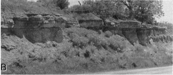
King Hill shale member--The King Hill member is chiefly yellow, greenish, and gray clayey to calcareous shale and averages about 17 feet in thickness. A rather persistent yellow, soft, impure siltstone or "boxwork" limestone which weathers yellow brown occurs in the upper part (Pl. 4B). Locally another impure calcareous siltstone occurs in the lower part. Except for a few brachiopods and mollusks at the top of the member it is mostly unfossiliferous.
Beil limestone member--The Beil limestone member averages 5 or 6 feet in thickness but where it includes considerable limy shale it is as much as 11 feet thick. In northern exposures the upper part consists of alternating beds of limy abundantly fossiliferous shale and thin flaggy to nodular limestone which weathers gray to tan. The lower part is more massive, irregular to wavy bedded, gray, fossiliferous limestone. Fusulinids, many brachiopods, bryozoans, mollusks, algae, and corals are abundant.
In central and southern outcrops it comprises 5 or 6 feet of gray, irregular to wavy bedded massive limestone characterized by its abundant corals, especially Caninia torquia and Syringopora multattenuata and many fusulinids. Its characteristic fauna and position above the black fissile shale of the underlying shale member serve to differentiate this member readily from other limestones of the Shawnee group.
Queen Hill shale member--The Queen Hill shale member, which underlies the Bell limestone, averages about 3 feet in thickness and may be divided into two parts. The upper part is tan to gray, blocky to thin-bedded unfossiliferous clay shale. The lower 0.2 to 1.5 feet is hard, black, carbonaceous, fissile shale. Conodonts are found in the black shale.
Big Springs limestone member--The Big Springs limestone, comparable to the Leavenworth and Rock Bluff limestone members of other Shawnee megacyclothems, is a dark gray-blue dense hard massive limestone bed. It has prominent vertical joints, the edges of which weather rounded. It commonly is about 1 foot thick, but is as much as 3 feet thick locally. Thicker sections may contain a thin shale break. Fusulinids are abundant, but algae, bryozoans, brachiopods, echinoderm fragments, and mollusks occur in the member also.
Doniphan shale member--Shale beds ranging from 5 to 27 feet in thickness comprise the Doniphan member. The upper part, 2 to 12 feet thick, commonly is a gray clay shale, thin-bedded or blocky, in places much like an underclay. Locally it contains a few mollusks. Middle beds in southern outcrops contain a thin sandy or conglomeratic molluscan limestone, 3 or 4 feet of silty shale and siltstone, and another thin molluscan limestone. Lower beds in the south comprise 5 to 10 feet of gray or greenish blocky to thin-bedded shale.
Beds below the underclay-like shale in northern and central areas locally contain a thin zone of carbonized plant material with abundant ostracods underlain by 3 to 4 feet of gray shale and unfossiliferous siltstone. A thin conglomeratic molluscan limestone occurs locally at the base of these middle beds. In a few exposures the middle beds are chiefly gray calcareous shale.
Lower beds in northern and central outcrops comprise 2 to 4 feet of interbedded calcareous shale and shaly limestone containing abundant fusulinids directly overlying the massive Spring Branch limestone.
Spring Branch limestone member--The basal member of the Lecompton formation is the Spring Branch limestone. This member is characterized by its abundant fusulinids in nearly all outcrops. Other fossils are less abundant. It is massive yellow-brown to brown ferruginous slightly wavy-bedded limestone locally somewhat sandy or silty. A thin parting or shale break occurs near the middle in many of the outcrops. Thickness of the member averages about 5 feet.
Kanwaka Shale
Shale beds ranging from 62 to 83 feet thick between the Oread and Lecompton limestones comprise the Kanwaka shale. It includes two shale and one limestone member. Beds of sandstone in the Kanwaka shale yield small supplies of ground water to several wells.
Stull shale member--The Stull shale, upper member of the Kanwaka formation, averages about 23 feet in thickness. It is chiefly blue-gray to gray clayey, silty, and sandy shale and very fine micaceous sandstone. Derbyia, Leda, Yoldia, Pharkidonotus, and Bellerophon occur in the upper part in northern and central outcrops. Carbonized plant remains and limonite nodules occur locally in middle and lower parts.
Clay Creek limestone member--The Clay Creek member is a bluish-gray, gray-brown weathering fine-grained to granular limestone about 3 or 4 feet thick. It commonly is massive and dense and contains abundant fusulinids. Bryozoans, crinoid fragments, brachiopods, and Osagia are present in parts of the member. A thin crust of broken brachiopod, crinoid, and bryozoan fragments about 0.2 foot thick is common at the top of the member. In the upper middle part a thin shale parting is present. The shale parting expands southward. Along the Osage-Coffey County line about as much shale as limestone is present.
Jackson Park shale member--The Jackson Park shale, lower member of the Kanwaka shale, averages 40 to 50 feet in thickness. Bluish-gray yellowish-tan weathering sandy and silty shale and gray tan-weathering fine-grained quartz sandstone comprise most of this unit. Carbonized land plant remains occur in the shale and locally it contains a thin coaly streak. As much as 30 feet of massive sandstone occurs locally in the lower part of the member.
Oread Limestone
The Oread formation is the lowermost and thickest of the scarp-forming Shawnee group limestones. Its average thickness is about 75 feet. The formation is divided into four limestone and three shale members. It is not an important aquifer, although shallow dug wells obtain small domestic and stock-water supplies locally.
Kereford limestone member--The Kereford limestone member is the thickest of the Oread limestones, along most of its line of outcrop averaging about 16 feet in thickness but locally is as much as 25 feet. It is variable in lithology, the upper part being granular or oolitic algal-molluscan limestone in some exposures. Next lower is thin dense blue-gray flaggy limestone with many featheredge shale partings. The flaggy limestone is the predominant part of the member and is mostly void of conspicuous fossils. In the lower 5 or 10 feet a sequence, from the base of the platy unfossiliferous limestone downward, of molluscan and brachiopod limestone, fusulinid-bearing limestone, and algal-coral limestone is commonly observed. This part is generally somewhat wavy-bedded. Locally this fossiliferous part includes a thin shale or shaly limestone.
The Kereford makes a secondary bench above the massive Plattsmouth limestone throughout most of its outcrop area.
Heumader shale member--The Heumader shale member averages 4 or 5 feet in thickness but locally is less than 1 foot thick. It is mostly clayey to silty gray or greenish shale, but may include a very thin brownish-red zone. Mollusks, bryozoans, or brachiopods are present at a few places but fossils are not abundant.
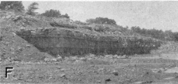
Plattsmouth limestone member--Light bluish-gray to nearly white limestone that weathers light gray or tan comprises the Plattsmouth member. Average thickness is about 13 feet but as much as 22 feet has been measured (Pl. 4F). The member comprises dense fine-grained wavy-bedded limestone with scattered nodules of blue-gray chert. Fossils, many of which are replaced with clear crystalline calcite, are abundant and include brachiopods, bryozoans, crinoid fragments, corals, algae, mollusks, and fusulinids. Thin wavy featheredge shale partings are common.
Plate 4F--Duesnbury quarry in Plattsmouth limestone member, sec. 3, T. 18 S., R. 16 E.
Heebner shale member--Similar in thickness and lithology and occupying the same cyclic position as the Larsh-Burroak and Queen Hill shale members is the Heebner shale member. It averages about 6 feet in thickness but has a range from about 3.5 to 10 feet. The upper part is blue-gray to olive-gray clay shale mostly unfossiliferous, underlain by 2 to 5 feet of black fissile conodont-bearing shale. Small grayish-brown phosphatic nodules occur sparingly in the black shale.
Leavenworth limestone member--The Leavenworth limestone member ranges from 0.9 to 2.5 feet thick. It comprises a single massive bed of gray-blue, creamy-tan weathering, hard fine-grained vertically jointed limestone. Fusulinids are common; other fossils, especially small mollusks, are numerous also.
Snyderville shale member--Predominantly shaly strata between the Leavenworth and Toronto limestone members is included in the Snyderville member. This unit exhibits large variations in lithology and thickness over short distances, ranging from less than 5 feet to about 40 feet, averaging perhaps 25 feet. Except in the thin exposures of Snyderville the sequence of beds is as follows. At the top, 1 to 5 feet of gray or tan-gray blocky clay is underlain by calcareous gray to yellow-tan shale, thin siltstone, and argillaceous limestone. Locally a thin conglomeratic limestone less than 1 foot thick is present near the middle. The lower shale beds may contain a thin impure limestone partly mudcracked and containing sparse mollusks and an algal limestone a few feet above the Toronto member.
Toronto limestone member--The Toronto limestone is the lowermost member of the Oread formation. It ranges from a nodular light-gray rather weak limestone to a more typical massive, buff- to brown-weathering, hard limestone. A variety of fossils are present, fusulinids, brachiopods, and crinoid fragments being abundant in most exposures. Corals and mollusks are present in less abundance and locally the upper part is platy algal (?) limestone containing ostracods. Thickness of the member is commonly about 8 or 9 feet but may be as much as 13 feet.
Douglas Group
Lawrence Shale
The two named members of the Lawrence formation, the Amazonia limestone and Ireland sandstone, crop out in southeastern Osage County although half or less of the formation is exposed at the surface.
That part of the formation occurring between the Toronto and Amazonia limestones ranges from about 5 to 32 feet in thickness and contains the Upper Williamsburg coal (Bowsher and Jewett, 1943). In addition to the coal, which ranges from 0.1 to 1.9 feet in thickness, beds of gray silty to sandy shale, a few inches of underclay, and less commonly a few feet of calcareous fine sandstone are present. The coal bed occurs from 0.5 foot to 30 feet below the Toronto limestone.
Sandstone in the Lawrence shale, chiefly the Ireland member, yields water to many wells in southeastern Osage County. It is an important aquifer.
Amazonia limestone member--The Amazonia member is a thin gray to blue-gray dense laminated algal (?) limestone. Thin veinlets of greenish clay occur irregularly through the limestone. It ranges from 0.5 to about 2 feet in thickness and is relatively nonresistant to weathering. Brachiopods are sparse in a few exposures.
Ireland sandstone member--The name Ireland sandstone member is applied to one or more beds of sandstone below the Amazonia limestone member. The sandstone is light gray when fresh but the small amounts of iron oxide present cause the sandstone to weather to various shades of tan, buff, and brown. The sandstone is unfossiliferous, chiefly fine to very fine quartz with a small percentage of mica and clay minerals. The sandstone grades laterally into sandy or silty shales.
Parts of the Lawrence shale between the Amazonia limestone member and the first beds of sandstone (Ireland) which underlie it are silty micaceous gray shale and locally include one or two thin sandy impure limestones.
Prev Page--Permian || Next Page--Structural Geology
Kansas Geological Survey, Geology
Web version April 2002. Original publication date May 1955.
Comments to webadmin@kgs.ku.edu
The URL for this page is http://www.kgs.ku.edu/General/Geology/Osage/02_strat3.html