![]()
Prev Page--Table of Contents || Next Page--Quaternary
Part 1--Rock Formations of Osage County
by Howard G. O'Connor
Introduction
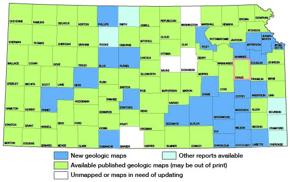
During the summer of 1947 the State Geological Survey of Kansas and the United States Geological Survey, in cooperation with the Division of Sanitation of the Kansas State Board of Health and the Division of Water Resources of the Kansas State Board of Agriculture, began a series of reports on the stratigraphy, economic geology, and ground-water resources of eastern Kansas counties. The reports consist chiefly of maps but contain brief descriptive stratigraphy, together with discussions of mineral and groundwater resources. The present status of these investigations is shown in Figure 1.
Geography
Osage County lies in central eastern Kansas as shown in Figure 1. It has an area of approximately 721 square miles or 20 townships.
Figure 1--Index map of Kansas showing area described in this report and areas covered by other geologic maps, as of Feb. 2002. For additional information, the KGS Geologic Maps of Kansas Page.
According to the 1950 census, Osage County has a population of 12,811. The principal cities are Osage City, 1,919; Burlingame, 1,065; Lyndon, 729; Scranton, 487; Carbondale, 453; Overbrook, 387; Quenemo, 391; and Melvern, 389. Agriculture is the principal industry.
Physiographically the area is a part of the Osage Plains (Schoewe, 1949). The topography is that of a dissected plain developed on unequally resistant shale and limestone formations. This gives rise to a gently rolling topography of vales and escarpments with moderate to steep slopes adjacent to most of the river and creek valleys. Land surfaces range from about 875 feet to 1,300 feet above sea level.
Marais des Cygnes River and its tributaries drain about 90 percent of the county and the remaining 10 percent is drained by Wakarusa River.
Normal annual precipitation recorded at Lyndon, Kansas, is 34.76 inches. About 71 percent of the precipitation in this area falls during the usual 6-month growing season.
Methods of Investigation
Most of the field work on which this report is based was done by me assisted by James Conkin in the summer and fall of 1951. In 1949 Hubert Hall and Keith Lowell spent about 3 months in the field measuring rock sections in detail, using a rule, Locke level with stadia, and telescopic level with a 12-foot rod. In 1950 Ralph O'Connor and Raymond Boardman spent approximately 3 months continuing the stratigraphic studies. J.M. Jewett spent several days in the field during the stratigraphic investigations and aided in these studies.
Areal geology was mapped on air photographs (scale 1: 20,000) and transferred by means of a Focalmatic desk projector to a base map (scale 1:40,000) adapted from a United States Department of Agriculture, Soil Conservation Service drainage and base map.
Test drilling was done in June 1951 and July and August 1953 with a portable hydraulic-rotary drilling machine owned by the State Geological Survey and operated by W.T. Connor, assisted at various times by Dick Connor, Warren Hodson, John Bashor, K.L. Walters, and C.K. Bayne. The altitude of the land surface at each test hole was determined by level parties headed by C.K. Bayne and W.W. Wilson.
Previous Geologic Work
The sequence of rocks which crop out in Osage and other eastern Kansas counties has been studied and described by many geologists (Prosser, 1895; Hall, 1896; Beede, 1898; Moore, 1936; Moore and Landes, 1937; Moore, Frye, and Jewett, 1944; Moore and others. 1951; Mudge and Burton, 1950; O'Connor, 1953). Coal resources of the area have been studied by Haworth (1898); Whitla (1940); Bowsher and Jewett (1943); Schoewe (1946); and Abernathy, Jewett, and Schoewe (1947). A report on mineral waters, including some from Osage County, was published by Bailey (1902).
The subsurface geology has been described by McClellan (1930); Lee and others (1946); Lee, Leatherock, and Botinelly (1948); and Lee and Merriam (1954). The geology pertaining to oil and gas has been discussed by Jewett and Abernathy (1945) and by Jewett (1954). Named structures that have geographic application to Osage County have been listed by Jewett (1951).
Acknowledgements
Appreciation is expressed to the many persons who furnished information on wells and water supplies, quarrying, and mining operations. Stratigraphic sections measured by nearly a dozen other members and former members of the Survey staff were utilized in preparation of this report and their help is acknowledged.
The manuscript of this report has been reviewed critically by several members of the Federal and State Geological Surveys; by Dwight Metzler, Director and Chief Engineer, and Willard O. Hilton, Geologist, Division of Sanitation, Kansas State Board of Health; and by R.V. Smrha, Chief Engineer, Division of Water Resources, Kansas State Board of Agriculture.
Prev Page--Table of Contents || Next Page--Quaternary
Kansas Geological Survey, Geology
Web version April 2002. Original publication date May 1955.
Comments to webadmin@kgs.ku.edu
The URL for this page is http://www.kgs.ku.edu/General/Geology/Osage/01_form.html