![]()
Prev Page--Rock Formations || Next Page--Permian
Stratigraphy of Outcropping Rocks
The rocks which crop out in Osage County range in age from Pennsylvanian to Quaternary and all are of sedimentary origin. Their areal extent is shown on Plate 1. In pages devoted to descriptions of the rock succession in Osage County, statements of thickness and distribution apply to this county only unless otherwise indicated.
Quaternary System
Quaternary deposits in Osage County consist chiefly of fluvial deposits. In addition to the alluvium and low terraces (flood-plain complex) which comprise the modern flood plains of the present streams there are a series of successively older and higher terraces and terrace remnants along the principal valleys. Precise dating of these deposits has not yet been possible, age determinations being suggested by degree of weathering, physiographic position, and comparison with more conclusively dated terraces in the adjacent Cottonwood-Neosho River basin to the south and Kansas River basin to the north.
Loess and colluvial slope deposits occur as discontinuous and thin veneers along the valley slopes and some of the upland flats but are not mapped.
Pleistocene Series
Recent and Wisconsinan Stages
Stream Valley Alluvium
Deposits of stream-laid gravel, sand, silt, and clay occur in the stream valleys and constitute the flood plains of the valleys. In general the alluvial fills grade upward from a gravel fill in the deeper part to a silt or clay at the surface. The maximum accumulations are about 40 feet thick in Marais des Cygnes River Valley and less in the smaller tributary valleys.
The coarse fraction is composed chiefly of chert, quartz, limestone, sandstone, and shale detritus derived from the Pennsylvanian, Permian, and Quaternary rocks which crop out in the Marais des Cygnes and Wakarusa River drainage basins. Descriptions of the alluvium are given in the record of test holes at the end of this report and are shown in cross section in Figure 3.
In the larger stream valleys two separate levels of alluvial deposits can be recognized locally as comprising the flood plain. The older and higher level averages perhaps 90 percent of the flood plain. This level occupies the entire flood plain in many areas of the valleys. In the wide parts of the valleys this surface is flat and poorly drained (cross section A-A', Fig. 3). Valley width, depth of fill, gradient, and surface configuration of the flood plains are adjusted to and modified by the local bedrock of the area.
The younger and lower alluvial surface comprises perhaps 10 percent of the flood plain but ranges from 40 percent to little or none of the flood-plain complex locally. This surface is characterized by surface irregularities and scarring wherever it forms an appreciable part of the flood plain. It occurs 2 to 10 feet below the older, higher part of the flood plain.
The extent of stream-valley alluvium (flood plain), except very narrow belts in small valleys, is shown on Plate 1. It is an important source of ground water. Older Pleistocene terrace deposits are mapped with the alluvium in the small tributary valleys.
Illinoian Stage (?)
Terrace Deposits
An older and less extensive terrace occurring 10 to 15 feet above the flood plain can be recognized and mapped above the valley alluvium. This terrace rests on a bedrock surface 5 to 15 feet above the bedrock beneath the alluvium (cross section A-A', Fig. 3). The sediments comprising these deposits are similar to those of the alluvium and have a maximum thickness of about 35 feet. A description of the lithology of these deposits is given in the log of test hole 18-14-9ac at the end of this report and its relation to older and younger terraces is shown in cross section A-A' (Fig. 3).
The age of this terrace is not certain but it is thought to be equivalent to the Wiggam terrace along Neosho River (O'Connor, 1953, pp. 6-7) and of probable Illinoian age. The extent of these deposits is shown on Plate 1. Illinoian fluvial deposits in the area east of the Flint Hills and south of Kansas River have not yet been positively identified but are believed to be represented by the highest elements of the low terrace complex (Frye and Leonard, 1952, p. 112).
Illinoian (?) terrace deposits are an important source of ground water.
Kansan Stage (?)
Terrace deposits of probable Kansan age occur intermittently along the valley sides. The basal deposits of this terrace rest on an eroded surface 10 to 30 feet above the flood-plain surface. Maximum thickness of these deposits is 40 feet. The lithology of these Kansan (?) sediments is similar to that of the alluvium and Illinoian (?) terrace except for degree of weathering and consequent color changes. The log of test hole 15-15-35cc and the cross sections (Fig. 3) illustrate the nature of these deposits and the relation of this terrace to other Quaternary deposits.
Throughout most of their extent Kansan terrace deposits have only a thin or intermittent zone of saturation. Locally they are a source of small supplies of ground water.
Quaternary and Tertiary Systems
Nebraskan Stage (?) and Pliocene Series (?)
Remnants of three alluvial terraces occur at elevations 60 to 75, 80 to 95, and 140 to 160 feet above the present alluvial flood-plain surface in the Marais des Cygnes River Valley. The lowest of these is probably of Nebraskan age and the two higher levels are Pliocene or older in age.
These high-level terrace remnants are lithologically similar and consist of siliceous sand and gravel, principally chert, up to several inches in diameter and were derived chiefly from the Wolfcampian (Permian) rocks of the Flint Hills region. The brownish-red clay matrix which fills the interstices between gravels and the complete leaching of all calcareous material indicate that the deposits have been subjected to prolonged weathering. Thickness of these gravels ranges from a few inches to about 12 feet (Pl. 4A, 4E). The three terrace levels are not distinguishable on the basis of their lithology. Topographic position is the chief means of differentiating these high-level terrace gravels.
Plates 4A and 4E--Chert gravel quarry in Pliocene (?) terrace deposits, sec. 27, T. 17 S., R. 14 E.
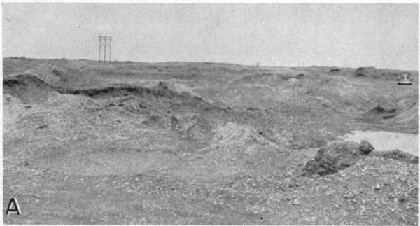
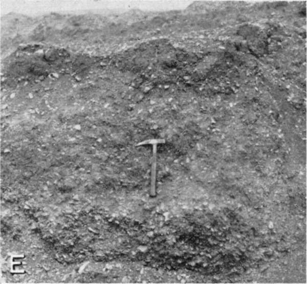
Cross section A-A' (Fig. 3) and Plate 1 illustrate the relation of these gravels to the younger terrace deposits. As these terrace gravels are traced eastward along Marais des Cygnes River drainage their relative position in the local topography becomes higher.
They are generally above the water table and are not an important source of ground water.
Prev Page--Rock Formations || Next Page--Permian
Kansas Geological Survey, Geology
Web version April 2002. Original publication date May 1955.
Comments to webadmin@kgs.ku.edu
The URL for this page is http://www.kgs.ku.edu/General/Geology/Osage/02_strat.html