![]()
Prev Page—Outcropping Rocks || Next Page—Mineral Resources
Structural Geology
A detailed analysis of the structural geology of Miami County is beyond the scope of this report. There are, however, certain features produced by regional and local structure, which are easily seen in the exposed rocks, and these are described.
Regional Structure
The Chautauqua Arch, which is a major pre-Mississippian structural element, indirectly affected the attitude of the Mississippian and Pennsylvanian rocks, in that the tectonic activity which caused the arch tilted the surface upon which these rocks were deposited.
Lee, et al. (1946) described a structural element they termed "the Ancestral Forest City Basin," the axis of which extends southward from southeastern Atchison County to southern Miami County. The Forest City Basin is the major post-Mississippian basin east of the Nemaha Anticline in northeastern Kansas. Originally it was both a topographic and a structural basin in which the earliest Pennsylvanian rocks of this part of Kansas were deposited (Lee and Payne, 1944).
Another important structural feature in eastern Kansas is the Prairie Plains monocline (Prosser and Beede, 1904). As a result of this post-Permian structure, the Pennsylvanian rocks in Miami County have a regional dip to the northwest of about 20 feet per mile. A structural contour map of Miami County (Fig. 3) using the base of the Kansas City Group as a datum plane shows many smaller anticlinal and synclinal structures superimposed upon the monocline.
Local Structures
The Prairie Plains monocline in Miami County is marked by a number of small local structures. Within these structures there are local reversals of dip, or accentuation of normal regional dip. These structures partially control the drainage patterns.
Local reversal of the regional dip (northwest about 20 feet per mile) was seen at a number of places in Miami County. In the NW cor. sec. 2, T. 17 S., R. 22 E., the lower part of the Wyandotte Limestone and the upper part of the Lane Shale have a southward dip of about 30 In the southern part of T. 15 S., R. 23 E., south of the community of Spring Hill, the rocks have a south-southeast dip.
A small northeast-trending anticline about 1 mile long is in sec. 33, T. 16 S., R. 22 E. and sec. 4, T. 17 S., R. 22 E. (Pl. 1). The northeast end of the anticline intercepts a northwest-trending syncline having a length of about three-fourths of a mile. An intermittent stream flows northeastward approximately along the axis of the anticline nearly to the east side of sec. 33, T. 16 S., R. 22 E., then turns southeastward and flows nearly along the axis of the syncline. The limbs of the structures have dips of as much as 120 locally. These structures affect rocks from the Lane Shale upward through the Captain Creek Limestone Member of the Stanton Limestone.
Another small anticlinal structure is in NW SW sec. 23, T. 16 S., R. 23 E. A minor flexure in the Iola Limestone, the axis of which trends northeast, is seen at this location. The regional dip is accentuated on the northwest limb of the structure. Two other small flexures occur in the Iola Limestone south of Louisburg along U.S. Highway 69.
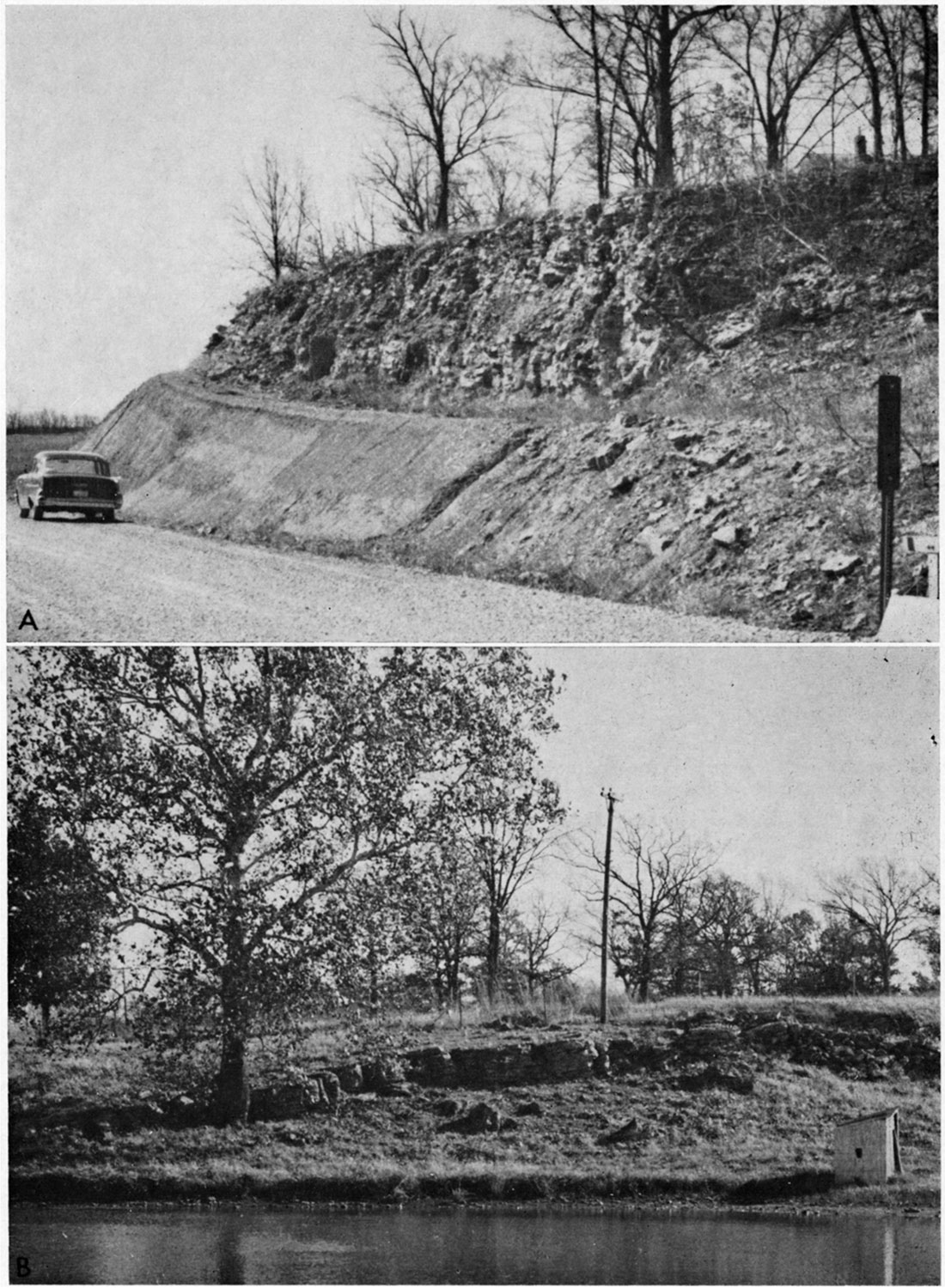
The area around Somerset, in eastern Miami County, contains many anomalous structures. In SW SW sec. 33, T. 16 S., R. 24 E., an outlier of Wyandotte Limestone dips 50 to the southwest and the base of the unit is at an altitude of 970 feet above mean sea level. About 0.8 mile south of Somerset, in SE SE sec. 5, T. 17 S., R. 24 E., an outlier of Wyandotte dips northeastward at about 8 and the base is at an altitude of 920 feet (Fig. 9, A). South Wea Creek, east of Somerset, flows in a southwesterly direction from a point 1 mile east of Somerset until it reaches a point 1 mile south of town. At this point the stream changes direction and flows to the northwest. This change in direction of the stream is probably the result of a small local structure.
Figure 9—A, Wyandotte Limestone overlying Lane Shale. Beds dip northeastward about 8°; SE SE sec. 5, T. 17 S., R. 24 E. B, Limestone bed in lower part of Wyandotte Limestone (overlapping Lane Shale) dipping 15° to the northwest. View toward northeast from top of Iola Limestone, which dips northwestward at about 5°; NE NW NE sec. 32, T. 16 S., R. 24 E.
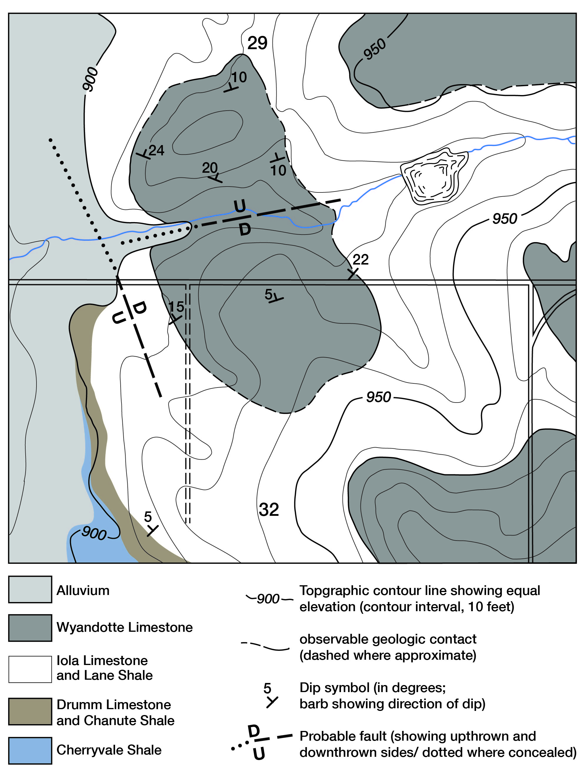
North of Somerset, in SE sec. 29 and in NE sec. 32, T. 16 S., R. 24 E., a structure affects rocks identified as Drum Limestone upward through Wyandotte Limestone (Fig. 10). A block of Wyandotte Limestone in the S SE sec. 29, and NW NE sec. 32, T. 16 S., R. 24 E., having an area of approximately 1,600 square yards, is exposed east of North Wea Creek. The base of this outlier of Wyandotte is 12 to 60 feet lower than beds of the Wyandotte one-quarter mile to the east. The southeast corner of this block has a dip of about 22 to the northwest and the southwestern part of the block dips to the northwest at about 150 (Fig. 9, B). The northwestern part of the limestone block, however, dips northeastward at 240. The north side of the block dips north at about 100. A small ravine, which probably marks a minor fault, cuts across the block in an east-west direction in sec. 29 and seems to mark the line where the direction of dip changes from northwesterly to northerly. It is probable that a north-northwest-trending fault, partly covered by alluvium, cuts along the west edge of the Wyandotte outlier. At this location, the Drum and Iola limestones either are faulted down to the east or dip northwestward under the alluvium of North Wea Creek.
Figure 10—Geologic map of a structureally deformed area north of Somerset in secs. 29 and 32, T. 16 S., R. 24 E., Miami County, Kansas.
Causes of Local Structures—The Miami County area has been depressed and raised many times during geologic time, and it is reasonable to assume that the amount of movement has not been uniform over the entire area. Gravitational gliding of the consolidated or partly consolidated sediments as a result of these regional movements could possibly produce structures like those in the vicinity of Somerset.
Some of these structures may be reflections of the original Precambrian surface. McQueen (1932) shows a high on the Precambrian surface underlying anomalies in the younger rocks in a cross section along the Missouri line in eastern Linn County. Differential compaction of sediments around Precambrian highs probably produced minor structures, which are reflected in surface rocks.
It is possible that collapse of overlying sediments into openings produced by solution in the Mississippian limestones has produced a few of the minor structures seen at the surface.
Prev Page—Outcropping Rocks || Next Page—Mineral Resources
Kansas Geological Survey, Miami County Geohydrology
Comments to webadmin@kgs.ku.edu
Web version June 2002. Original publication date June 1966.
URL=http://www.kgs.ku.edu/General/Geology/Miami/06_struc.html