![]()
Prev Page—Subsurface Stratigraphy || Next Page—Structural Geology
Geology—Stratigraphy of Outcropping Rocks
Correlation of units discussed in this report on the basis of measured sections is shown on Plate 3. Descriptions of measured sections are at the end of the report.
Pennsylvanian System—Missourian Stage
Pleasanton Group
Tackett Formation
The Tacket Formation (Jewett, et al., 1965) is the oldest outcropping formation in Miami County (Pl. 1). It is composed of three units, which are, in ascending order, a lower shale member, a middle limestone member, and an upper shale member. The Formation has an average thickness of 120 feet. It is a slope-forming unit, but it is poorly exposed along its outcrop in valleys in the southeastern part of the county.
Only about 25 feet of the upper shale member of the Tacket Formation is exposed in Miami County. This is predominantly of continental origin and is composed of olive-gray to grayish-orange sandy shale with thin, nodular limestone beds occurring locally.
A series of fine-grained, cross-bedded sandstone lenses ranging in thickness from 0 to 25 feet occurs in the upper part of the Tacket Formation at varying distances below the overlying Hertha Limestone. This sandstone is termed the "Knobtown" by drillers in the area. Study of the sandstone indicates that it consists of a number of separate lenses, which were probably deposited by streams flowing across a surface of low relief (D.A. Hatcher, 1961, written communication).
Kansas City Group—Bronson Subgroup
Hertha Limestone
The Hertha Limestone (Adams, et al., 1903) comprises in ascending order: the Critzer Limestone Member and the Mound City Shale Member, which are exposed only locally, and the Sniabar Limestone Member, which is the most persistent member of the Hertha in Miami County.
The Hertha is poorly exposed where it crops out along the valleys in the southeastern part of the county. In most localities it has a thickness of about 8 feet, but averages slightly more in the subsurface.
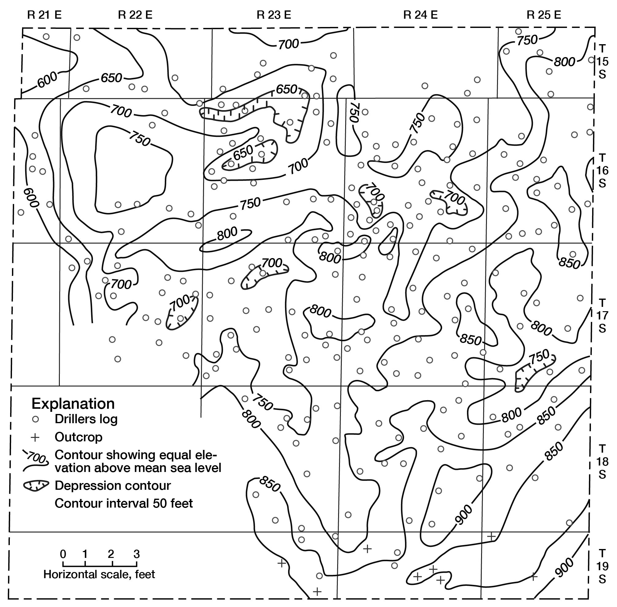
Structural contours drawn at the base of the Hertha (base of the Kansas City Group) show an irregular surface (Fig. 3). The local relief on this surface is probably the result of an initial irregularity at the time of deposition and subsequent regional movement of the rocks.
Figure 3—Structural contour map on the base of ther Kansas City Group in Miami County, Kansas. (Based on data from surface outcrops and from well logs in files of State Geological Survey of Kansas.)
Critzer limestone Member—The Critzer Limestone Member (Jewett, 1932) was observed at only a few localities in Miami County. It is exposed in SE SE sec. 10, T. 19 S., R. 24 E., where it is composed of 1.0 foot of light olive-gray, medium-grained, cherty limestone with abundant crinoid remains and some bryozoans.
Mound City Shale Member—The Mound City Shale Member (Jewett, 1932) occurs only locally in Miami County. It is exposed at the location mentioned above in the description of the Critzer (SE SE sec. 10, T. 19 S., R. 24 E.), where it consists of 0.4 foot of dusky-yellow, unfossiliferous sandy shale.
Sniabar Limestone Member—The Sniabar Limestone Member (Jewett, 1932) is a medium- to coarse-grained, medium- to thick-bedded limestone with an average thickness of about 6 feet. It is the most lithologically variable unit in the lower part of the Kansas City Group. In NE SE sec. 34, T. 18 S., R. 24 E., it is oolitic at the top and contains chert in the lower part. In SE NW sec. 10, T. 19 S., R. 23 E., abundant hematite pebbles are found in a conglomerate composed of limestone phenoclasts in a calcareous matrix at or near the base of the Member. Insoluble residues of the conglomerate have a high percentage of oolitic and oomoldic chert. The conglomerate was probably derived from erosion of the Critzer Limestone Member, as it occurs at approximately the same stratigraphic position.
In most localities in Miami County the Sniabar Limestone Member is composed of two distinct limestone beds separated by a thin bed of shale. In NW SW sec. 33, T. 18 S., R. 24 E., the stratigraphic position of the shale is occupied by a breccia composed of angular limestone fragments. In the upper and lower limestone beds of the Sniabar, zones of bellerophontid gastropods are locally found. Algal encrustations are also quite common in the upper part of the Member.
Ladore Shale
The Ladore Shale (Adams, et al., 1904) is light-gray to olive-gray and weathers to a yellowish-gray. It is usually sandy; however, locally, as in SE NW sec. 10, T. 19 S., R. 23 E., it is calcareous and includes a thin limestone bed near the middle. The Ladore ranges in thickness from 1.2 feet in the NW SW sec. 33, T. 18 S., R. 24 E., to 11.4 feet in the NW NE sec. 19, T. 18 S., R. 24 E. The formation is unfossiliferous in Miami County, except for plant impressions in the sandy layers.
Swope Limestone
The Swope Limestone (Newell, 1935) comprises two limestone members and one shale member, which are, in ascending order: Middle Creek Limestone Member, Hushpuckney Shale Member, and Bethany Falls Limestone Member. The Swope is well exposed along the streams in the southern part of Miami County but has no distinctive topographic expression. Throughout the county it has a thickness of about 34 feet and is easily distinguished from units above and below by the characteristic lithology of its members.
Middle Creek Limestone Member—The Middle Creek Limestone Member (Newell, 1932) is a medium-gray to bluish-gray, fine-grained, dense limestone that commonly is seen in the outcrop as a single massive unit. It is brittle and has vertical joints 2 to 3 feet apart that form large, sharp-edged blocks. Locally, as in SE NW sec. 10, T. 19 S., R. 23 E., there are two limestone beds separated by a thin shale parting. The upper limestone has a thickness of 0.6 foot and the lower limestone of 1.8 feet. The thickness of the Middle Creek throughout most of the county is fairly constant, rarely more than 2.5 feet or less than 1.8 feet.
Hushpuckney Shale Member—The Hushpuckney Shale Member (Newell, 1932) is named for Hushpuckney Creek, south of Fontana in Miami County. It consists of black fissile shale in the lower part and grayish sandy shale in the upper part. The Member has an average thickness of about 4 feet but attains a maximum thickness of 7.5 feet in NE NW sec. 6, T. 19 S., R. 25 E. At this location the lower 1.2 feet is black fissile shale and the upper 6.2 feet of the unit is yellowish-gray sandy shale. Where the Hushpuckney is relatively thin (3.9 feet), as in NW SW sec. 33, T. 18 S., R. 24 E., it appears that the thinning has been at the expense of the upper, sandy unit. Locally a thin bed of light olive-gray shale underlies the black shale.
The upper part of the Hushpuckney is fossiliferous, with chonetid brachiopods and a species of productid brachiopod being the most abundant forms.
Bethany Falls Limestone Member—The uppermost member of the Swope Limestone, the Bethany Falls Limestone Member (Broadhead, 1866) ranges in thickness from about 13 feet near the SE cor. sec. 34, T. 18 S., R. 24 E., to about 28 feet in the SE NW sec. 10, T. 19 S., R. 23 E. It is a light-gray to light brownish-gray, medium-grained, medium- to thick-bedded sandy limestone containing numerous thin shale partings. In most areas the Member can be conveniently divided into two fairly distinct parts. The lower 12 to 16 feet of the Member contains fusulinids.
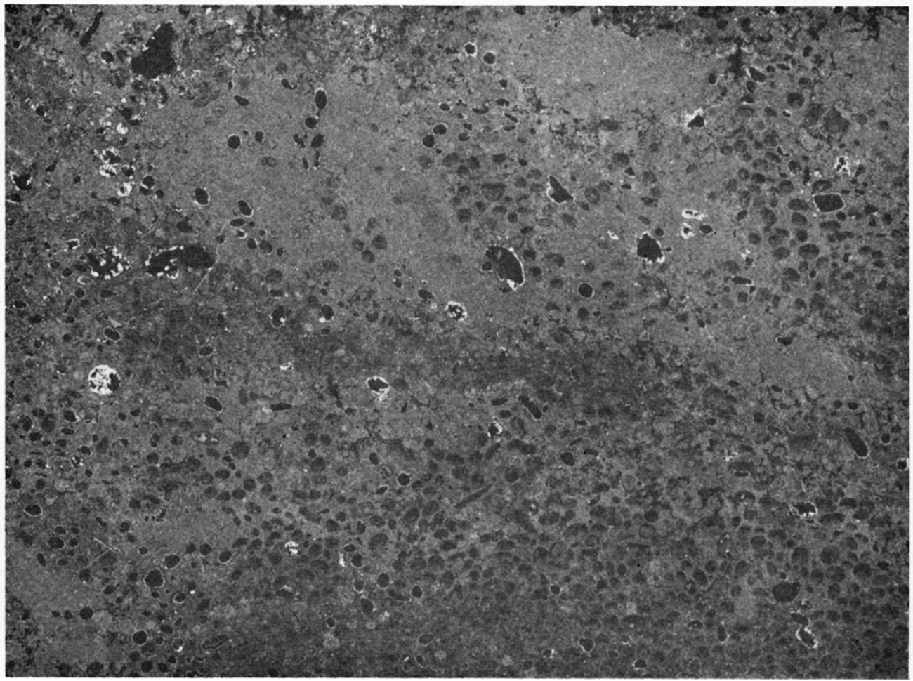
The upper part of the Member is cherty and locally has cross-bedded, pelletal limestone and (or) oolites in the extreme upper part (Fig. 4). Where the pelletal or oolitic limestone is present, the upper part locally contains vertical, tubular cavities containing iron-stained crystalline calcite. These cavities are 3 to 4 feet in length and 1 to 2 inches in diameter. The upper part of the Bethany Falls is the most variable in thickness, ranging from 0 to almost 14 feet. This irregularity is the result of thickening and thinning of the pelletal and oolitic part. The contact between the lower non-oolitic limestone and the oolitic limestone is quite uneven and possibly indicates a minor disconformity.
The Bethany Falls is a fossiliferous unit in which Meekella, Derbyia, Antiquatonia, arid chonetid brachiopods are most common. Triticites is found locally in the lower part of the unit. Algae are quite abundant locally.
Figure 4—Peel-print of the Bethany Falls Limestone Member of the Swope Limestone showing pelletal texture. Locality 56, SE SE NW sec. 10, T 19 S, R 23 E., X4.
Galesburg Shale
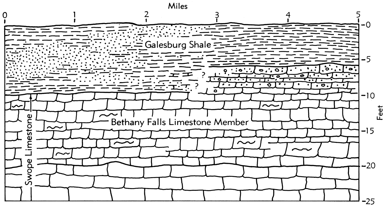
The Galesburg Shale (Adams, et al., 1903) in Miami County consists of greenish-gray to dusky-yellow, sandy to calcareous, blocky shale. Outcrops are restricted to stream valleys in the southern part of the county where the unit is poorly exposed. The Galesburg ranges in thickness from slightly less than 4 feet in the NE NW sec. 6, T. 19 S., R. 25 E., to about 12 feet in the NE SE sec. 34, T. 18 S., R. 24 E. It is usually thickest where the underlying Bethany Falls Limestone Member of the Swope Limestone is thin. Although not clearly evident on the outcrop, it appears possible that the oolitic upper part of the Bethany Falls locally was deposited concurrently with the lower part of the Galesburg Shale (Fig. 5). Whether the lateral change from limestone to shale is a gradual facies change or an interbedding of shale and limestone was not determined. The Galesburg is characteristically sparsely fossiliferous.
Figure 5—Idealized section of relationship of the Bethany Falls Limestone Member (Swope Limestone) and the Galesburg Shale.
Dennis Limestone
The Dennis Limestone (Adams, et al., 1903) forms prominent scarps and is well exposed in the southern part of the county. It has an average thickness of about 32 feet.
The Dennis in Miami County comprises two members, which, in ascending order, are: the Stark Shale Member and the Winterset Limestone Member. A third member, the Canville Limestone Member, which is the lowermost member of the Dennis, is absent in Miami County outcrops but is present a short distance to the south in Linn County. A thin, impure, nodular limestone is seen locally, however, at this horizon in Miami County and may represent the Canville. This nodular limestone is exposed in NW NE sec. 19, T. 18 S., R. 24 E.
Stark Shale Member—The lowermost member of the Dennis Limestone exposed in Miami County is the Stark Shale Member (Jewett, 1932). The lower part is black, fissile to very thin-bedded, carbonaceous shale. The upper part of the Stark consists of medium-olive to greenish-gray sandy shale and is about twice the thickness of the underlying black shale. Locally the olive and greenish-gray shale is absent, as in NE NW sec. 6, T. 19 S., R. 25 E., and the black shale is in contact with the overlying limestone. The thickness of the Stark ranges from 0.9 foot at the location mentioned above to almost 6 feet in NW NE sec. 19, T. 18 S., R. 24 E.
The Stark is fossiliferous in the upper, sandy part, with chonetid brachiopods being the most common type. The lower part is unfossiliferous except for rare inarticulate brachiopods.
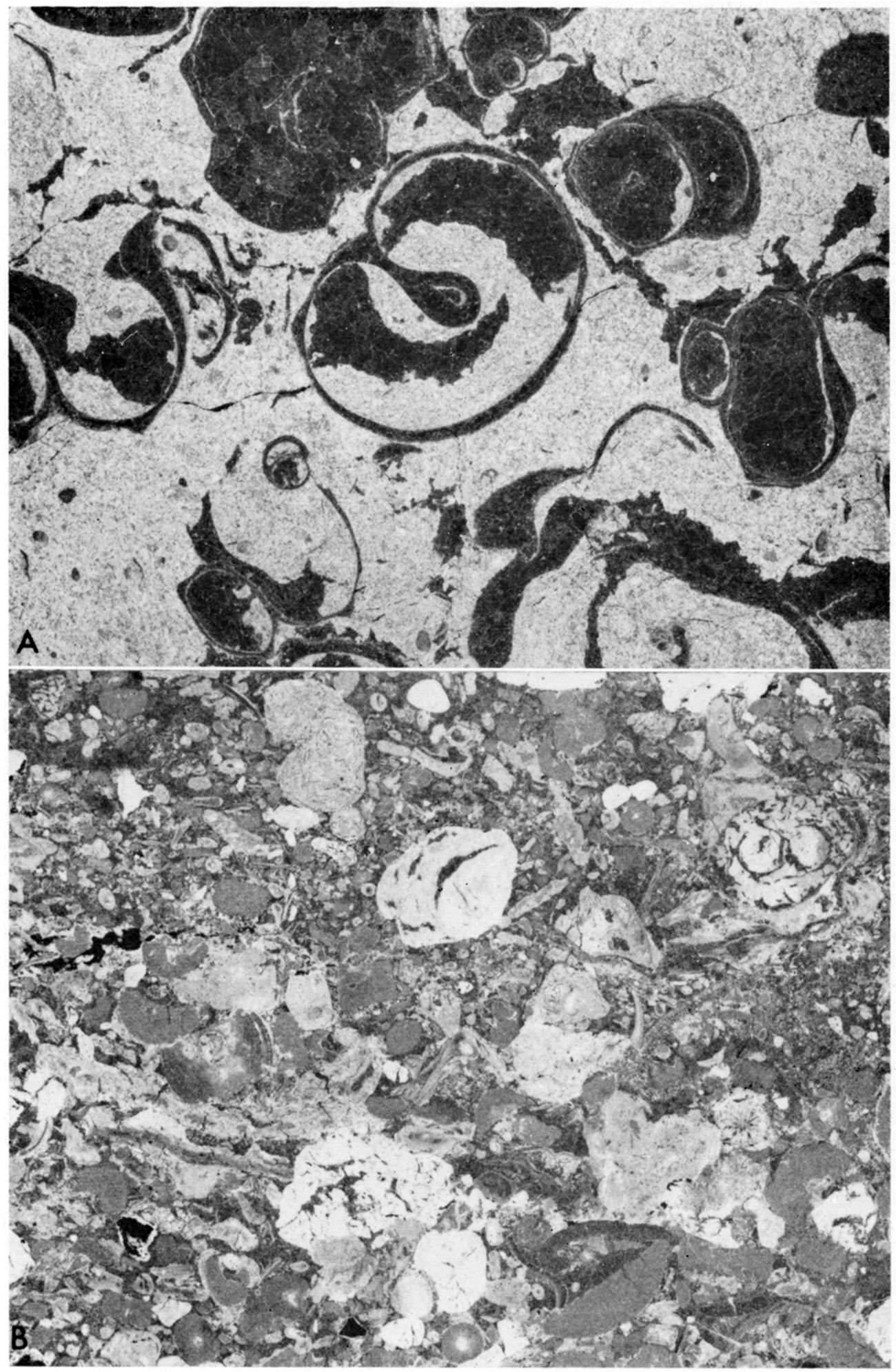
Winterset Limestone Member—The Winterset Limestone Member (Tilton and Bain, 1897) is the uppermost member of the Dennis Limestone. It is light gray to olive gray, medium grained, medium bedded and dense in the lower part and more fine grained in the middle part. The lower and middle parts of the Member characteristically contain shaly partings and much chert. The upper part is usually separated from the lower beds by a thin bed of calcareous gray shale, which in SW NE sec. 12, T. 18 S., R. 23 E. attains a thickness of 1.5 feet. In NW SE sec. 27, T. 18 S., R. 23 E., two thin shales separated by 1.5 feet of soft, impure, wavy-bedded limestone are present. The upper part of the Winterset is dense, fine-grained, massive limestone. It contains an abundance of dark-gray chert and locally, as in NE NW sec. 27, T. 18 S., R. 24 E., is oolitic near the top. Commonly the oolite is restricted to the topmost 1 to 3 feet and does not characterize the entire upper part. The upper part of the Winterset is very fossiliferous and is characterized by numerous large productid brachiopods and locally by abundant gastropods (Fig. 6, A). Triticites is also very abundant in the upper part and is strikingly displayed in the dark chert nodules. The Winterset in Miami County has an average thickness of about 29 feet.
Figure 6—A, Peel-print of upper part of the Winterset Limestone Member of the Dennis Limestone showing abundant gastropods. Note fine-grained texture of enclosing matrix; dark areas are secondary calcite. Locality 45, SW NW SE, sec. 27, T. 18 S., R. 23 E., X4. B, Peel-print of the Westerville Limestone Member of the Cherryvale Shale showing conglomeratic texture. Locality 51, SW SW NW sec. 7, T. 18 S., R. 24 E., X4.
Kansas City Group—Linn Subgroup
Cherryvale Shale
The Cherryvale Shale (Haworth and Bennett, 1908) comprises beds between the top of the Dennis Limestone and the base of the Drum Limestone. It includes, in ascending order: the Fontana Shale Member, the Block Limestone Member, the Wea Shale Member, the Westerville Limestone Member, and the Quivira Shale Member. The Cherryvale has a great range in thickness in the subsurface, with a maximum of about 100 feet in the northeastern part of T. 16 S., R. 23 E., and a minimum of 40 feet in the extreme northeastern part of the county. At outcrops it has an average thickness of about 60 feet, but it is not well exposed.
Fontana Shale Member—The Fontana Shale Member (Newell, 1935) is typically exposed in the vicinity of Fontana in southeastern Miami County. The Fontana is greenish-gray to olive-gray sandy shale. Locally a thin, nodular limestone occurs in the lower part, as in SW NE sec. 12, T. 18 S., R. 23 E. Where the limestone is absent, the interval is commonly marked by a thin layer of iron-stained calcareous shale. The Fontana has an average thickness of about 15 feet in Miami County. It is relatively unfossiliferous except for sparse chonetid brachiopods in the lower part.
Block Limestone Member—The Block Limestone Member (Newell, 1935) is the lowermost limestone unit of the Cherryvale Shale and is named from exposures 0.25 mile east of the community of Block in southeastern Miami County. It is a bluish-gray to olive-gray medium-grained, thin-bedded fossiliferous limestone with numerous thin, fossiliferous shale partings. Insoluble residues from samples collected from the top of the unit show abundant ooliths and oomolds.
Triticites is the most characteristic fossil, but Marginifera and Syringopora also are abundant. The average thickness of the Member in Miami County is about 4 feet.
Wea Shale Member—The Wea Shale Member (Newell, 1935), named from Wea Creek in northeastern Miami County, occupies the interval between the Block and the Westerville Limestone members. The Wea is characteristically olive-gray sandy shale containing sandstone beds locally near the base. The sandy layers are typically exposed in SW SW sec. 6, T. 18 S., R. 24 E. A thin bed of maroon shale occurs near the top of the Member at several exposures. Locally, pyritiferous nodules and limonite concretions occur in the Wea.
The Wea attains its greatest thickness in Miami County in SW NW sec. 16, T. 17 S., R. 24 E., where it is about 28 feet thick; the average thickness is about 18 feet. Fossils are rare in the Wea, but in SW NW sec. 7, T. 18 S., R. 25 E., plant impressions and carbonaceous smudges are found at its top. In places a very thin coal occurs near the top of the Member.
Westerville Limestone Member—The Westerville Limestone Member (Bain, 1898) was studied at only a few scattered localities. In SW NW sec. 7, T. 18 S, R. 25 E., the Westerville is composed of about 2 feet of conglomeratic limestone containing abundant limonite nodules and quartz sand (Fig. 6, B). In SW NW sec. 16, T. 17 S., R. 24 E., the unit is composed of a 1-foot bed of yellowish-gray marly limestone. The different lithologies and the sporadic occurrence of the Westerville in Miami County may indicate a local disconformity at this horizon.
Quivira Shale Member—The lower part of the Quivira Shale Member is composed of black, carbonaceous, fissile shale (Newell, 1935). It is characteristically exposed in a road cut in SW NW sec. 7, T. 18 S., R. 25 E. In SW SW sec. 24, T. 18 S., R. 24 E., the black fissile shale is absent and maroon clayey shale occurs at this horizon. Though these two types of rock occur in the same stratigraphic position, they have not been observed in the same outcrop. The black shale and the maroon shale are usually quite thin (0.5 to 1.0 foot) and rest directly on the Wea Shale Member in localities where the Westerville Limestone Member is missing. The upper part of the Quivira consists of olive-gray sandy shale. In NW SW sec. 25, T. 18 S., R. 22 E., a thin dark-gray fissile shale occurs directly below the overlying Drum Limestone. The dark shale probably represents the entire Quivira at this locality.
The Quivira has an average thickness of about 4 feet. It is unfossiliferous, except for sparse inarticulate brachiopods and conodonts in the black fissile shale.
Drum Limestone
The Drum Limestone (Adams, et al., 1903) consists of a single massive bed of yellowish-gray to reddish-brown fine- to medium-grained limestone that is uniform in lithology and easily recognizable. Locally, as in NE NE sec. 6, T. 17 S., R. 24 E., the upper part weathers into thin slabs, which show cross-bedding. The slabs are dark-brown, coarse-grained limestone and are separated by thin calcareous shale partings. The Drum is thickest where the cross-bedded upper part is present, and, at the location mentioned above, it has a thickness of about 8 feet. The thinnest outcrop of Drum measured in the county was 1.7 feet thick. The Member has poor topographic expression in Miami County.
The most characteristic feature of the Drum is the occurrence of abundant, small, white crinoid segments scattered throughout the limestone. Other fossils found in the Drum are Neospirifer, Marginifera, and Composita, and locally, as in NW SW sec. 25, T. 18 S., R. 22 E., the small sponge Heliospongia.
Chanute Shale
The Chanute Shale (Haworth and Bennett, 1908) varies greatly in thickness and lithology over short lateral distances. It is about 8 feet thick near Paola and about 38 feet thick north of Block. The Chanute is characteristically yellowish-brown to greenish-gray sandy to clayey shale. It contains sandstone locally in the lower and middle parts and commonly in the upper part. In SW cor. sec. 6, T. 17 S., R. 23 E., sandstone rests directly on the underlying Drum Limestone (Pl. 3). In the northern part of T. 19 S., R. 22 E., where the sandstone is about 30 feet thick, there is very little shale in the Chanute. A few miles north, in NW SW sec. 25, T. 18 S., R. 22 E., the Chanute has 32 feet of shale and no sandstone. The Chanute Shale is a relatively unfossiliferous unit except for plant impressions found locally in the sandy layers.
Over a large area the Chanute contains the Thayer coal, which ranges in thickness from 0 to 0.5 foot. The coal is 11 to 15 feet above the base of the formation, and no coal occurs where the Chanute is thinner than 11 feet, or where sandstone occupies this interval, as it does in NW NE sec. 16, T. 18 S., R. 25 E. The Thayer occurs at differing stratigraphic positions in respect to the upper formational boundary. In SW NW sec. 7, T. 18 S., R. 25 E., a thin, nodular limestone overlying 8 feet of greenish-gray, clayey shale is found at the base of the formation. At the same stratigraphic position in NW NE sec. 33, T. 16 S., R. 23 E., there is a 2-foot bed of maroon shale overlying 6 feet of olive-green pyritiferous shale.
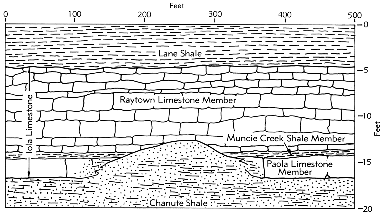
Iola Limestone
The Iola Limestone (Haworth and Kirk, 1894) comprises two limestone members and one shale member. They are, in ascending order: the Paola Limestone Member, the Muncie Creek Shale Member, and the Raytown Limestone Member. The Iola has an extensive outcrop area and lithologically is fairly consistent. It has an average thickness of about 10 feet north of the Marais des Cygnes River and about 12 feet south of the river.
Paola Limestone Member—The Paola Limestone Member (Newell, 1932) is named for exposures north of Paola, and in most localities it is a single massive bed of dark-gray to brownish-gray, fine-grained, dense limestone with an average thickness of about 2.5 feet. In the southern part of the county, the Paola locally becomes more coarse grained and weathers into thin slabs. The contact with the underlying shale is fairly smooth, but the upper surface of the unit is very irregular or "hummocky" (Newell, 1935). Locally, iron-stained "worm tubes" extend downward 1 to 3 inches from the upper surface of the Paola.
The Paola is missing in several places in Miami County. In SW SW sec. 6, T. 17 S., R. 23 E., the Iola Limestone is 5.7 feet thick and the Paola Limestone Member is absent. A few miles east of Paola in NW NW sec. 24, T. 17 S., R. 23 E., the Iola is about 4.0 feet thick and the Paola Limestone Member is absent. Apparently the Paola is absent in these areas as a result of non-deposition over irregularities of the upper surface of the Chanute Shale (Fig. 7). The actual interface relationship of the Paola Limestone Member and the Chanute Shale around the areas of nondeposition was not observed. The Paola, however, does become more sandy when traced toward these areas.
Figure 7—Idealized section showing the relationship of the Iola Limestone and the Chanute Shale in areas of nondeposition of the Paola Limestone Member of the Iola Limestone.
Crinoid stems and small productid brachiopods are the most abundant fossils in the Paola Limestone Member. Encrusting algae of the Osagia type and bryozoans are quite common locally. Insoluble residues of samples from the Paola indicate that quartz sand was available only very locally during deposition of the unit; the bulk of the residue is fine silt, clay, and a small amount of pyrite.
Muncie Creek Shale Member—The Muncie Creek Shale Member (Newell, 1932) is a very distinctive unit in Miami County. It is a bluish-gray to dusky-yellow sandy shale that has a dark-gray, carbonaceous, fissile facies locally, as in SE SE sec. 7, T. 17 S., R. 23 E. The average thickness of the Muncie Creek is about 0.5 foot.
The most diagnostic feature of the Muncie Creek is the presence of spherical or ellipsoidal phosphatic nodules 1/4 to 1 inch in maximum diameter. The surface of these nodules weathers white or light gray, but the interior remains black or dark gray. Most of the nodules have small fossil fragments at their centers.
Many theories have been proposed as to the origin of phosphatic nodules in sediments. Blackwelder (1916) has said that ammonium phosphate generated by the decay of pelagic organisms might be the agent of precipitation of phosphatic nodules. Emigh (1958) states that phosphatic pellets or nodules in the Phosphoria Formation (Permian) in Idaho were originally nodules of calcium carbonate built around organic debris, which were replaced later by calcium phosphate. The latter theory probably explains the occurrence of the nodules in the Muncie Creek Shale Member.
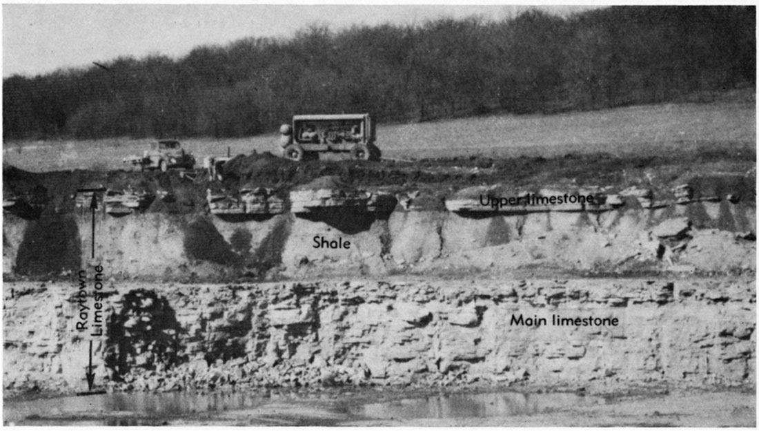
Raytown Limestone Member—The Raytown Limestone Member (Hinds and Greene, 1915) ranges in thickness from about 5 feet in SW SW sec. 29, T. 17 S., R. 24 E., to about 24 feet in SE SE sec. 7, T. 17 S., R. 23 E. It is a light olive-gray to light-gray medium- to coarse-grained limestone with numerous silty shale partings and abundant vugs lined with crystalline calcite. The Raytown is medium bedded in the northern part of Miami County but becomes progressively inure thin bedded when traced toward the southern part of the county. In SE SE sec. 7, T. 18 S., R. 23 E., there are three thin limestone beds separated by shale which altogether have a thickness of 3.7 feet, and which occur about 4 feet above the main limestone bed of the Member. In the SE SE sec. 18, T. 18 S., R. 23 E., the upper limestones are thicker, better developed, and lie about 7 feet above the main limestone bed of the Raytown (Fig. 8).
Abundant large productid brachiopods occur in the Raytown, with Echinaria and Linoproductus being the most common. West and south of Osawatomie, small sponges resembling Girtyocoelia are present in the lower part of the Member. The coiled cephalopod Knightoceras was found in the upper part of the Member in SE SE sec. 9, T. 16 S., R. 23 E.
Figure 8—Quarry exposure of the Raytown Limestone Member of the Iola Limestone, showing upper 3-foot limestone bed and 7-foot shale bed above the main limestone ledge of the Member, SE SE SE sec. 18, T. 17 S., R. 23 E.
Kansas City Group—Zarah Subgroup
Lane Shale
The Lane Shale (Haworth and Kirk, 1895) has considerable variation in lithology and thickness. In the western half of the county the Lane has an average thickness of about 80 feet and is an olive-gray to dusky-yellow silty to sandy shale and thin-bedded siltstone. In the eastern half it is an olive-gray to light-gray clayey shale with an average thickness of about 25 feet. The Lane ranges in thickness from about 16 feet in NE NE sec. 2, T. 18 S., R. 23 E. to about 108 feet in SE sec. 7, T. 16 S., R. 23 E. The Lane is a slope-forming unit, and it produces a rounded topography.
Thin carbonaceous streaks 1/16- to 1/4-inch thick are found locally in the Lane, but none is sufficiently continuous or thick enough to be termed a coal bed.
In SW SW sec. 17, T. 17 S., R. 22 E., there is a thin zone of light-gray, clayey shale containing laminae of reddish-brown calcareous silt just below the overlying Wyandotte Limestone. Pettijohn (1957) states that laminae of this type were probably deposited in deep, quiet waters and may indicate lower than normal salinity of the sea water. Newell (1935) reported that the laminated zone is quite common in the western part of the county. In SW NE sec. 27, T. 18 S., R. 22 E., a thin 0.4-foot-thick sandy, micaceous limestone replaces the laminated zone.
The Lane is essentially unfossiliferous except for sparse plant remains. Locally, as in SW SW sec. 5, T. 17 S., R. 25 E., there are small brachiopods and crinoid remains in the upper few feet of the formation.
Wyandotte Limestone
The Wyandotte Limestone (Newell, 1932) comprises three limestone members and two shale members. They are, in ascending order: the Frisbie Limestone Member, the Quindaro Shale Member, the Argentine Limestone Member, the Island Creek Shale Member, and the Farley Limestone Member. The Wyandotte is a distinctive cuesta-forming formation, which is well exposed in Miami County. It ranges in thickness from about 10 to 80 feet. The shale members are present only locally in Miami County. The absence of the shale members and the similarity in the lithology of the two upper limestone members makes identification of the units difficult.
Frisbie Limestone Member—The Frisbie Limestone Member (Newell, 1932) is the most easily identifiable member of the Wyandotte. It is a light olive-gray to light brownish-gray, fine-grained, massive limestone. Locally, as in SW SW sec. 5, T. 17 S., R. 25 E., it is composed of 0.5 foot of limestone overlain by 0.2 foot of shale and 1.0 foot of limestone, but in SE NE sec. 27, T. 17 S., R. 25 E., it is composed of three limestones and two shales. At several localities, the Frisbie is absent or has undergone a facies change and is not recognizable. The Frisbie has an average thickness of about 2.5 feet. The maximum thickness noted was 3.6 feet in NE SE sec. 11, T. 18 S., R. 21 E.
Crinoid stems and small productid brachiopods are the most common fossils found in the Frisbie. The unit locally contains Osagia-like forms.
Quindaro Shale Member—The Quindaro Shale Member (Newell, 1932) is a dusky-yellow to dark yellowish-orange, sandy shale. Locally, as in SW SW sec. 5, T. 17 S., R. 25 E., the lower part of the Quindaro is very dark gray. The Member is absent in many Wyandotte outcrops. The thickness ranges from 0 to about 3.3 feet.
The Quindaro is very fossiliferous with Heterocoelia, Dielasma, and Phricodothyris being the most common forms. Crinoid fragments and bryozoans are also abundant, and in SW SW sec. 5, T. 17 S., R. 25 E., sponges resembling Heliospongia are found.
Argentine Limestone Member—The Argentine Limestone Member (Newell, 1932) is probably the most persistent member of the Wyandotte. Its identification in Miami County is primarily by stratigraphic position, as its lithology is similar to the Farley Limestone Member, which is normally the uppermost limestone member of the Wyandotte. Locally the Farley Limestone Member is missing and the Argentine Limestone Member is the uppermost member. The Argentine is a light olive-gray to grayish-orange, medium-grained, thin-bedded, locally cherty limestone, which weathers into thin fragments. In SE SE sec. 5, T. 17 S., R. 24 E., where the Frisbie Limestone Member and the Quindaro Shale Member are absent, the Argentine is very fractured.
The range in thickness of the Argentine Limestone Member is difficult to determine, but in SW SW sec. 1, T. 16 S., R. 24 E., where the overlying Island Creek Shale Member is present, about 37 feet of Argentine was measured.
The Argentine has a varied fauna with the brachiopods Composita, Echinaria, Antiquatonia, and Phricodothyris being most common. Enteletes is abundant west and south of Paola. The fusulinid Triticites is common locally.
Island Creek Shale Member—The Island Creek Shale Member (Newell, 1932) was tentatively identified at only two localities in Miami County. In SW SW sec. 1, T. 16 S., R. 24 E., it has a thickness of 1.6 feet and is a grayish-orange clayey shale containing abundant gastropods. In NW NE sec. 4, T. 16 S., R. 25 E., there is 0.4 foot of gray clayey shale, which is probably Island Creek.
Farley Limestone Member—The Farley Limestone Member (Hinds and Greene, 1915), where present, is the uppermost member of the Wyandotte Limestone. It is a light olive-gray to pinkish-gray coarse-grained, wavy, thin- to thick-bedded limestone. In NW NE sec. 4, T. 16 S., R. 25 E., the Farley has a thickness of 15 feet, and the lower part of the Member is medium bedded and oolitic. Where the underlying Island Creek Shale Member is absent, the Farley rests directly on the Argentine Limestone Member. Only at two localities, where the Island Creek Shale Member is identified, is the base of the Farley Limestone Member identified with certainty.
The Farley contains much the same fauna as the Argentine Limestone Member, except for the presence of a few scattered Aviculopecten in the lowermost part, at localities where the Island Creek Shale Member is present.
Bonner Springs Shale
The Bonner Springs Shale (Newell, 1932) is the uppermost formation of the Kansas City Group. In the lower part it is a pale olive- to light-gray sandy shale which in places, as in NE SW sec. 8, T. 16 S., R. 23 E., grades laterally into a thin-bedded micaceous siltstone. It is an olive-gray to yellowish-brown clayey shale in the upper part.
Near the middle of the formation is a zone of varied lithology. In NE NW sec. 29, T. 15 S., R. 23 E., this zone is composed of about 4 feet of grayish-red clayey shale that appears to be barren of fossils. In NE NW sec. 16, T. 16 S., R. 24 E., the zone is composed of 0.7 foot of medium-gray clayey shale containing carbonaceous streaks, plant rootlets, and leaf impressions. In NW NW sec. 21, T. 15 S., R. 22 E., a 6-foot bed of olive-gray medium-grained, medium-bedded, calcareous sandstone is found in this interval.
In areas where the formation is primarily clayey shale, scattered limestone nodules are present. In NE NW sec. 29, T. 15 S., R. 23 E., a thin, argillaceous limestone bed about 1-foot thick is present 2.0 feet below the top of the formation. The limestone bed is very fossiliferous and contains abundant pelecypods, algae, brachiopods, gastropods, and bryozoan fragments.
The Bonner Springs ranges in thickness from 0.9 foot in NE NW sec. 30, T. 16 S., R. 24 E. to 31.5 feet in NE SE sec. 19, T. 15 S., R. 23 E. The average thickness of the unit is about 20 feet.
Lansing Group
Plattsburg Limestone
The Plattsburg Limestone (Broadhead, 1866) is the lowermost formation in the Lansing Group. It comprises two limestone members and one shale member, named, in ascending order, the Merriam Limestone Member, the Hickory Creek Shale Member, and the Spring Hill Limestone Member. The Plattsburg has an average thickness of about 16 feet. It is a scarp-forming unit and has an extensive area of outcrop (Pl. 1).
Merriam Limestone Member—The Merriam Limestone Member (Newell, 1932) usually is easily recognizable and is commonly seen as a single, massive bed of bluish-gray to light-gray, fine-grained, dense limestone.
The Merriam is locally composed of two distinct divisions. The lower division is a massive, bluish-gray to light-gray limestone and is the persistent part of the Member. In NE NE sec. 8, T. 17 S., R. 22 E., the lower division comprises all of the Merriam and is cross-bedded and oolitic. In NE NW sec. 30, T. 16 S., R. 24 E., the lower division is 3.6 feet thick and has a zone of black, fossiliferous chert 1.7 feet above the base (Pl. 3). Elsewhere, as in NW NW sec. 2, T. 16 S., R. 23 E., a zone containing abundant Composita occurs in the lower division. Osagia-like forms are usually present and in some places these constitute a large part of the limestone. The large pelecypod Myalina is abundant locally, and productid brachiopods are common in the lower part of the Member. The upper of these two divisions is light- to medium-gray, fine-grained, massive, locally cherty limestone. It is generally not very fossiliferous but usually contains abundant "worm tubes" on the upper surface. Locally the upper division is separated from the lower division by a thin shale bed, as in NE NW sec. 16, T. 16 S., R. 24 E. At this location the upper division is cherty and has abundant crinoid and bryozoan remains. The average thickness of the Merriam is about 3.5 feet. The thickness ranges from about 1 foot to about 9.5 feet.
Hickory Creek Shale Member—The Hickory Creek Shale Member (Newell, 1932) is a yellowish-gray to orangish-gray, clayey, nodular, calcareous shale. It has an average thickness of slightly more than 2 feet, but locally it may be absent. A very thin, nodular limestone bed occurs near the middle of the Member in SW NW sec. 25, T. 16 S., R. 21 E., and in NE NE sec. 8, T. 17 S., R. 22 E., the entire Member is composed of nodular calcareous shale. The unit is fossiliferous with crinoid remains and bryozoans being the most common forms.
Spring Hill Limestone Member—The Spring Hill Limestone Member (Newell, 1932) is a light olive-gray to yellowish-gray, fine- to coarse-grained, thin- to medium-bedded, sandy limestone. It contains chert locally and in SE SE sec. 27, T. 16 S., R. 22 E. is oolitic at the top. In SE SE sec. 14, T. 15 S., R. 23 E., the Spring Hill has two shale partings and several thin wavy carbonaceous streaks. At several locations the Member has abundant fractures filled with iron-stained calcite crystals. In a quarry in NE NW sec. 27, T. 15 S., R. 22 E., the upper part of the Spring Hill is conglomeratic with abundant limonite pebbles, shale and ironstone fragments, and small abraded calcite crystals.
The Spring Hill ranges in thickness from 4 feet in SE SE sec. 8, T. 16 S., R. 23 E., to about 17 feet in SE NW sec. 7, T. 17 S., R. 22 E. Its thickness in the subsurface is variable and in places is more than 20 feet thick.
Triticites is common and Osagia-like forms are locally abundant. Echinoid spines are abundant locally in the Spring Hill, and Newell (1935) states that they are Echinocrinus. A zone of large Compositas is commonly found near the base of the unit. A zone containing Enteletes and Marginifera is usually associated with the carbonaceous streaks in the lower part of the Spring Hill. In SE NW sec. 7, T. 17 S., R. 22 E., The rock is made up principally of fenestrate bryozoan remains.
Vilas Shale
The Vilas Shale (Adams, 1898) is grayish-olive to light-gray, sandy, and blocky. In the western part of the county it contains a considerable amount of moderate yellowish-brown siltstone and orangish-gray cross-bedded sandstone. In SE NW sec. 7, T. 17 S., R. 22 E., there is a 4-foot bed of calcareous cross-bedded sandstone 4 feet above the Plattsburg Limestone. The Vilas ranges in thickness from about 5 feet in SW NW sec. 31, T. 15 S., R. 23 E., to about 30 feet where State Highway 68 crosses the county line into Franklin County. It has few invertebrate megafossils, but plant remains are common in the sandy layers.
Stanton Limestone
The Stanton Limestone (Haworth and Bennett, 1908) is the uppermost formation in the Lansing Group. It comprises three limestone members and two shale members, which are, in ascending order, the Captain Creek Limestone Member, the Eudora Shale Member, the Stoner Limestone Member, the Rock Lake Shale Member, and the South Bend Limestone Member. The upper member was not measured because it is not exposed, and the remaining members are poorly exposed. Because of the scarcity of outcrops in which all members are recognizable, the thickness of the Stanton in Miami County is difficult to determine, but in adjacent counties it is about 35 feet.
Captain Creek Limestone Member—The Captain Creek Limestone Member (Newell, 1935) is easily recognizable, both by its own distinct lithology and by the characteristic lithology of the units directly above and below. The lower part of the Captain Creek is medium gray and dense. The upper part is commonly a pale yellowish-brown to light-gray, medium-grained, thick-bedded, cherty limestone, which locally is sandy. At NW SE sec. 27, T. 15 S., R. 23 E., the upper part of the Member is oolitic. The chert is pale red and very pale blue and resembles medium-grained sand. It is finely disseminated and gives the upper part of the limestone a mottled appearance. At many of the exposures the upper part weathers into large, angular blocks.
The Member ranges in thickness from about 5 feet in NE SE sec. 26, T. 16 S., R. 21 E., to about 11 feet in NE NE sec. 8, T. 17 S., R. 22 E.
In NW SE sec. 27, T. 15 S., R. 23 E., a bed of bioclastic limestone 0.2-foot thick occurs at the base of the Captain Creek. The limestone contains brachiopods, crinoid stems, bryozoans, and what appear to be wood fragments replaced by calcium carbonate.
The Captain Creek contains abundant Enteletes, and the fusulinid Triticites is seen locally along the bedding planes.
Eudora Shale Member—The Eudora Shale Member (Condra, 1930) is an olive-gray to light yellowish-brown, clayey, blocky shale with a thin layer of black, fissile shale near the middle. Locally, the black shale makes up 40 to 50 percent of the Member. The thickness of the Eudora ranges from about 5.5 feet in SW SW sec. 4, T. 17 S., R. 22 E., to about 11 feet in NE SE sec. 26, T. 16 S., R. 21 E. It is relatively unfossiliferous except for sparse inarticulate brachiopods, conodonts, and rare conularids, which occur in the black shale.
Stoner Limestone Member—The Stoner Limestone Member (Condra, 1927) is poorly exposed and only in NW NW sec. 35, T. 15 S., R. 21 E. was the full thickness of the Member seen. Newell (1935) states that the low relief on the upland surface underlain by the Stoner is due to the resistant nature of the Member. It is probable, however, that the Stoner in Miami County was at about base level when the upper Tertiary surface was formed (J.M. Jewett, 1962, oral communication). This factor may explain the scarcity of exposures of the Stoner as well as of other members of the Stanton in Miami County.
At the location mentioned above, the Stoner is about 19 feet thick and is comprised of the following sequence of units, in ascending order: (1) 13.3 feet of yellowish-gray, medium-grained, uneven- and medium-bedded limestone which contains fusulinids, crinoids, and algae; (2) a 0.5-foot bed of yellowish-brown, arenaceous shale; (3) a 2.4-foot bed of grayish-orange, sucrose-textured, uneven- and medium-bedded limestone; (4) a 1.1-foot bed of yellowish-gray coarse-grained, wavy- and thin-bedded limestone which contains abundant gastropods, pelecypods, and brachiopods; (5) a 0.3-foot dusky-yellow, banded shale parting; and (6) a 0.5-foot bed of light-gray sandy limestone containing pelecypods, brachiopods, and small sponges.
Rock Lake Shale and South Bend Limestone Members—Only the lowermost part of the Rock Lake Shale Member (Condra, 1927) was seen in Miami County. In NW NW sec. 35, T. 15 S., R. 21 E., about 4 feet of badly weathered gray shale in the lower part of the unit is poorly exposed.
The South Bend Limestone Member is probably present as a 3- to 5-foot-thick sandy limestone in the subsurface in the northwestern part of the county, but it is not exposed and was not studied.
Douglas Group
The nomenclature used here is the result of a redefinition of the lower boundary of the Douglas Group (Ball, 1963). The term "Pedee Group" was dropped from usage in Kansas by Ball, and the boundary of the Douglas Group was lowered to include all rocks to the top of the Lansing Group. The Weston Shale and the Iatan Limestone were reduced from formation to member rank, and the Stranger Formation was redefined to include rocks from the top of the Stanton Limestone to the base of the Haskell Limestone Member of the Lawrence Formation. The Lawrence Formation was redefined to include rocks between the base of the Haskell and the base of the Toronto Limestone Member of the Oread Limestone.
Stranger Formation
Weston Shale Member—The Weston Shale Member (Keyes, 1899) is the only member of the Stranger Formation identified in Miami County. It underlies the upland in the northwestern part of the county and is poorly exposed. It is composed of olive-gray to bluish-gray argillaceous shale, and limonite specks and nodules occur in it locally. The thickness of the Weston was not determined, but it is probably about 30 feet.
Lawrence Formation
Ireland Sandstone Member—The only member of the Lawrence Formation identified in Miami County is the Ireland Sandstone Member (Moore, 1932). It underlies the surface in the extreme northwestern part of the county (Pl. 1). The Ireland is 13 feet thick in a test hole in the NE cor. sec. 22, T. 15 S., R. 21 E. and is composed of fine to coarse silty, micaceous, quartz sand, with some fine to coarse gravel at the base.
Neogene System—Pliocene and Pleistocene Series
Pre-Kansan (Pliocene?) Deposits
Upland chert gravels—Locally deposits of chert gravel and silt are found in upland areas some distance from present drainage courses. These deposits are found at elevations about 200 feet above the flood plain of the Marais des Cygnes River and are sparsely scattered across bedrock surfaces. As the thickness of these deposits rarely exceeds 2 feet, they were not mapped and are not shown on Plate 1. They are probably Pliocene in age and reflect a surface across which eastward-trending streams flowed (Frye and Leonard, 1952).
Other deposits of Pliocene age are associated with or are near the present drainage course of the Marais des Cygnes River and are shown on Plate I. They form a veneer, having a maximum thickness of about 6 feet, and lie on rocks of Pennsylvanian age at elevations 50 to 70 feet above the present flood plain of the river. The deposits are leached and oxidized and consist mainly of chert pebbles in a yellowish-tan sandy clay matrix.
The similarity of the weathered condition and topographic position of these deposits with respect to known Pliocene deposits found elsewhere indicates that they are probably of Pliocene age.
Kansan Stage
Deposits consisting of gravel and silt are found on valley walls and on low saddles along valley walls (Pl. 1). The similarity of the weathered condition and topographic position of these deposits to deposits of known Kansan age indicates that these deposits are also Kansan in age. They are scattered and occur at elevations that are 20 to 35 feet above the flood plain of the Marais des Cygnes River. Their maximum thickness is probably no more than 10 feet. They consist mainly of chert pebbles but contain some rounded limestone pebbles in a yellowish-tan sandy silt matrix. Individual pebbles range in diameter from 1 to 3 inches.
Illinoisan Stage
Fluvial deposits, which are Illinoisan in age, occur in the valleys of the streams in Miami County (Pl. 1). These Illinoisan deposits underlie a terrace, which is about 8 feet above the flood plain at the terrace break and slopes up the valley wall to merge with the colluvium.
The deposits underlying the Illinoisan terrace are usually reddish-brown to yellowish-tan silt, which is locally sandy. Thin beds of gravel occur in places at the base of these deposits. The surface of the terrace is usually highly dissected.
Wisconsinan and Recent Stages
Deposits of Wisconsinan and Recent age consisting of sand, silt, and some gravel are found underlying the flood plain of the Marais des Cygnes River and its tributaries (Pl. 1). Due to their similar lithology these deposits were mapped as a unit.
The deposits consist of light-gray to tannish-gray silt with lenses of clay and fine to coarse sand. Gravel is present but is so sparse that it was rarely encountered in drill holes.
The surface of the alluvium is about 5 feet lower than the Wisconsinan terrace surface and is relatively flat and undissected. The maximum thickness of the Wisconsinan and Recent deposits in Miami County is about 55 feet (Pl. 2).
Prev Page—Subsurface Stratigraphy || Next Page—Structural Geology
Kansas Geological Survey, Miami County Geohydrology
Comments to webadmin@kgs.ku.edu
Web version June 2002. Original publication date June 1966.
URL=http://www.kgs.ku.edu/General/Geology/Miami/05_outc.html