![]()
Prev Page—Contents || Next Page—Geography
Introduction
Purpose and Scope of Investigation
An investigation of the geology and ground-water resources of Miami County, Kansas, was made to determine the distribution, thickness, lithology, and hydrologic properties of the rocks containing fresh water. Rocks older than Pennsylvanian age in this county probably do not contain fresh water, and, therefore, they are considered only briefly in this report. Other mineral resources and the structural geology of the area are discussed briefly. Data regarding the quantity and quality of the ground water in the various aquifers are summarized.
The study of the geology and ground-water resources of Miami County was begun in the summer of 1960 by the State Geological Survey of Kansas and the U.S. Geological Survey in cooperation with the Division of Water Resources of the Kansas State Board of Agriculture.
Location and Extent of Area
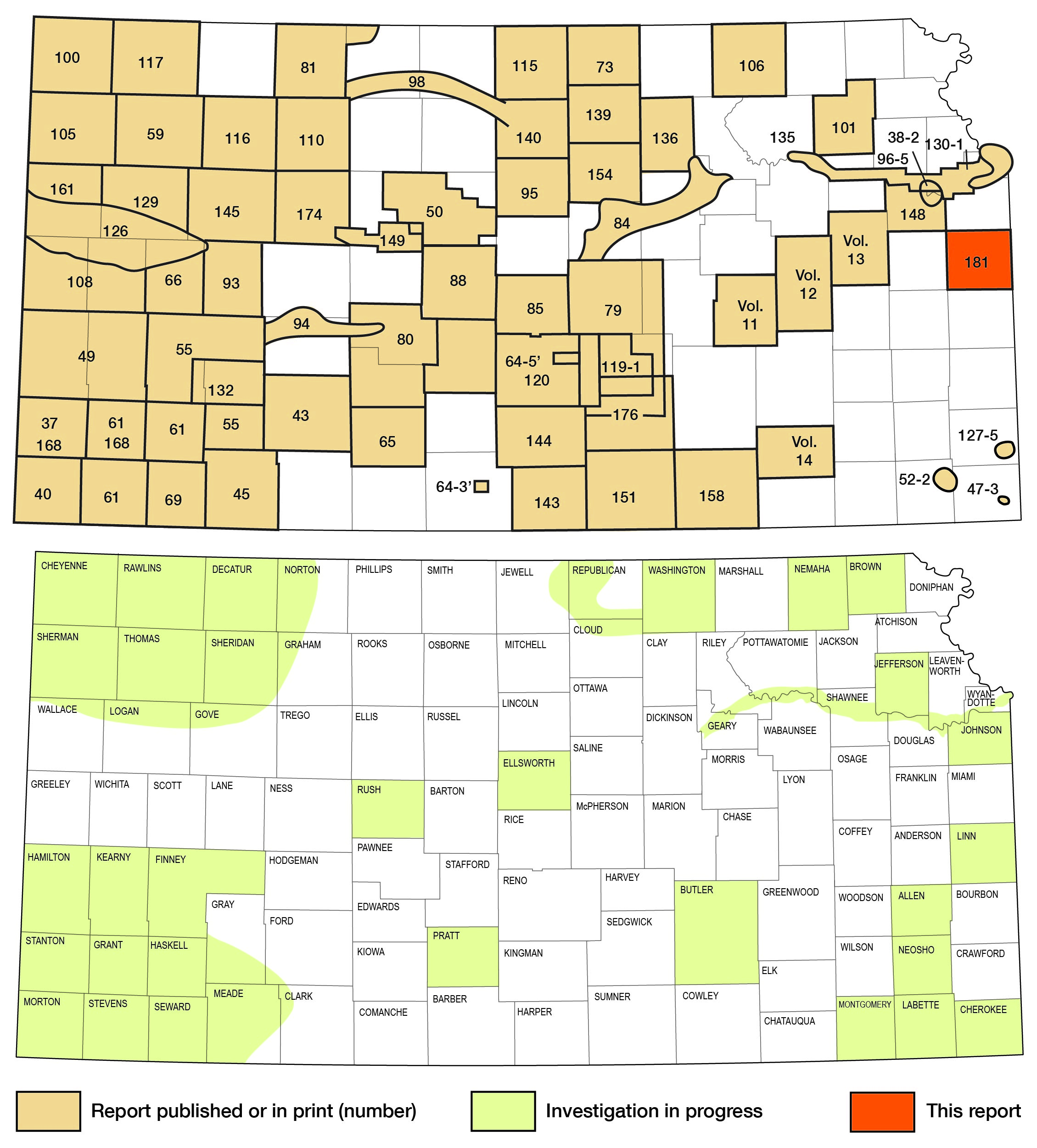
Miami County, located in east-central Kansas, includes all or parts of 25 townships and constitutes an area of 592 square miles (Fig. 1).
Figure 1—Map of Kansas showing area described in this report, and other areas for which ground-water reports have been published by the State Geological Survey of Kansas or are in preparation.
Previous Investigations
The geology of Miami County and adjacent areas has been studied and described by many geologists. The first study dealing with the geology of the county was in 1865 by G.C. Swallow. Early stratigraphic studies by J.M. Jewett (1932) and by N.D. Newell (1935) contributed much to the overall knowledge of the geology of the area and to the stratigraphic nomenclature of the outcropping Pennsylvanian rocks. Jewett described the rocks in the subsurface of the county in 1954.
Other studies dealing with the area are listed in the references at the end of this report.
Methods of Investigation
This report is based on geologic and hydrologic data gathered during the spring and summer, 1960-62.
The geology includes detailed examination and description of numerous geologic sections as well as areal mapping (Pl. 1). Some of the geologic data from a report on the area by Newell (1935) are incorporated into this report.
Supplementary information on the geology and hydrology of the area was provided by inventorying wells and by drilling test holes. The samples collected in the course of drilling were later examined microscopically in the laboratory.
The base map on Plate 1 was compiled from aerial photographs obtained from the U.S. Department of Agriculture and from maps of the Soil Conservation Service and the State Highway Commission of Kansas. Areal geology was mapped on aerial photographs and on topographic maps and was transferred to a base map with a scale of 1:40,000.
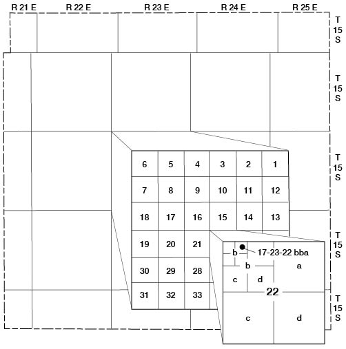
Well-Numbering System
The well and test-hole designations used in this report give the locations of wells following the scheme of General Land Office surveys. The well number is composed of the township, the range, and the section number, followed by lowercase letters, which indicate the subdivision of the section in which the well is located (Fig. 2). The first letter denotes the quarter section, the second letter denotes the quarter-quarter section, or 40-acre tract, and the third letter, when used, indicates the quarter-quarter-quarter section, or 10-acre tract. The 160-acre (quarter section), 40-acre, and 10-acre tracts are designated a, c, or d, in a counterclockwise direction, beginning in the northeast quarter.
Figure 2—Sketch of Miami County, Kansas, illustrating the well-numbering system used in this reports. The well is in sec. 22, T 17 S, R 23 E.
Acknowledgments
The author expresses his appreciation to the many residents who supplied information concerning local geology, wells, and water supplies. Several drillers provided logs of wells that they had drilled in this area.
Geologists of the State Highway Commission of Kansas made available much geologic information, including profiles of several highway projects. Analyses of water samples collected during this investigation were made by H.A. Stoltenberg, Chief Chemist, of the Environmental Health Services of the Kansas State Department of Health.
Stratigraphic sections and other unpublished data on the geology and ground-water resources of the area collected by many other members of the Federal and State Geological Surveys were utilized in the preparation of this report, and their help is gratefully acknowledged.
The author acknowledges especially the assistance of J.M. Jewett, H.G. O'Connor, and S.M. Ball, who were particularly helpful and generous with their time.
The manuscript for this report has been reviewed critically by several members of the Federal and State Geological Surveys; by R.V. Smrha, Chief Engineer, and H.L. Mackey, Engineer, Division of Water Resources, Kansas State Board of Agriculture; and by J.L. Mayes, Chief Engineer, and B.F. Latta, Geologist, Environmental Health Services, Kansas State Department of Health.
A major part of the section of this manuscript dealing with the stratigraphy of the outcropping rocks was used in the preparation of a master's thesis (Miller, 1963) at the University of Kansas. Thanks are extended to staff members of the Geology Department for their assistance.
Prev Page—Contents || Next Page—Geography
Kansas Geological Survey, Miami County Geohydrology
Comments to webadmin@kgs.ku.edu
Web version June 2002. Original publication date June 1966.
URL=http://www.kgs.ku.edu/General/Geology/Miami/02_intro.html