![]()
Prev Page--Geography || Next Page--Formations
Geology
[Note: The geologic classification and nomenclature of this report follow the usage of the State Geological Survey of Kansas as of the publications date and differ somewhat from those of the U. S. Geological Survey.]
Summary of Stratigraphy
The rocks exposed in Logan County range in age from Late Cretaceous to Recent (Pl. 1). The oldest rocks, which crop out in the eastern and central parts of the county along the Smoky Hill River valley, belong to the Smoky Hill chalk member of the Niobrara formation. The largest area of outcrop of the Pierre shale, which overlies the Niobrara formation, is in the western part of the county.
The Ogallala formation, of Pliocene age, unconformably overlies the Pierre shale and the Niobrara formation except in the Smoky Hill Valley, where it has been entirely eroded away. The Ogallala formation crops out in much of the county and is best exposed along the stream valleys and at the edge of the upland plain. The undissected upland plain is mantled by windblown silt (loess) of the Sanborn Group. Sand and gravel of late Pleistocene age mantles the dissected Pleistocene "pediments." In parts of sec. 18 and 27, T. 14 S., R. 33 W., some of these deposits have been reworked by the wind into active dunes. Colluvial deposits derived chiefly from loess are extensive on the steeper slopes in the Smoky Hill River valley and tributary valleys and are mapped as part of the Sanborn Group. Small areas of dune sand and alluvium in the Turtle Creek and Smoky Hill River valleys are the youngest deposits in the area.
The water-bearing character and lithology of the geologic formations are described briefly in Table 1. The stratigraphic relations of the formations ire shown in the geologic cross sections (Pl. 3, 4).
Table 1--Geologic formations of Logan County and their water-bearing properties. The classification is that of the State Geological Survey of Kansas.
| System | Series | Formation | Thickness (feet) |
Character | Water-bearing properties |
|---|---|---|---|---|---|
| Quaternary | Pleistocene | Alluvium | 0-35 | Sand, gravel, silt, and clay deposited in channels and flood plains of the major river valleys. | Where saturated, yields moderate to large quantities of very hard water to wells. |
| Dune sand | 0-20 | Fine sand and silt in dunes and blowouts on high divides. | Lies above the water table and does not yield water to wells. | ||
| Sanborn (Group) |
0-100 | Silt, yellowish gray, deposited as loess on uplands; locally contains thick deposits of sand and gravel at base beneath "pediments" along major streams. | Commonly lies above the water table, but Crete formation where saturated yields water to wells. | ||
| Meade (Group) |
0-50 | Silt and fine sand, yellowish gray and orange, and thick lenses of volcanic ash. May contain sand and gravel at base locally. | Commonly lies above the water table, but may supply water to wells in some draws and beneath high "pediments." | ||
| Tertiary | Pliocene | Ogallala formation |
0-220 | Calcareous sandstone containing lenses of reddish-gray clayey silt and persistent shale layers; contains some limestone beds and volcanic ash. | Yields moderate to large quantities of water to wells where sufficient thickness is saturated. |
| Cretaceous | Gulfian | Pierre shale |
0-300 | Medium to dark-gray fissile shale containing bentonite seams and abundant gypsum. | Not known to yield water to wells in Logan County. |
| Niobrara formation |
300-690 | Shaly chalk, grayish yellow orange to light gray, containing bentonite seams and abundant gypsum. | Yields water to wells in a few localities where sufficiently faulted and jointed. | ||
| Carlile shale |
215 | Dark-gray noncalcareous shale containing gypsum and large septarian concretions in the upper part and thick beds of chalky shale alternating with thin beds of chalk or chalky limestone. Upper 10 feet is a shaly sandstone, the Codell sandstone zone. | Yields minor amounts of mineralized water from Codell sandstone zone. | ||
| Greenhorn limestone |
125 | Thin chalky and crystalline limestones separated by thicker beds of medium-gray chalky shale. | Not known to yield water to wells in Logan County. | ||
| Graneros shale | 65 | Shale containing thin beds of sandstone and bentonite, dark to medium gray, noncalcareous, marine. | Not known to yield water to wells in Logan County. | ||
| Dakota formation |
300 | Shale and lenticular sandstone beds, variegated. | Yields moderate to abundant amounts of soft water to wells. |
Summary of Geologic History
Although the oldest formation exposed at the surface in Logan County is the Niobrara formation, it is known from the records of deep tests for oil and gas that the exposed rocks are underlain by older sedimentary rocks of Mesozoic and Paleozoic age, which in turn rest upon crystalline rocks of Precambrian age. Logs of test wells for gas and oil indicate that Logan County is underlain by at least 4,500 feet of sedimentary rocks of Paleozoic age. Before the Paleozoic era the crystalline rocks of Precambrian age had been eroded in places to local relief of about 1,000 feet.
During Early and Middle Cambrian time Logan County was above sea level, but in Late Cambrian time an interior sea advanced over the area. It persisted through most of the Ordovician period. During this submergence, extensive calcareous sediments were deposited, which are recognized in well cuttings and electric logs as the Arbuckle Group of Cambrian and Ordovician age and the Viola limestone of Ordovician age. In an oil-test well drilled in the center of sec. 13, T. 15 S., R. 33 W., the thickness of the Arbuckle Group is 550 feet, the thickness of the Viola limestone is 125 feet, and the top of the Ordovician rocks was penetrated at a depth of about 5,300 feet.
Rocks of Silurian and Devonian age are not known to underlie Logan County. A shallow sea or a low land mass may have been present, but no evidence of either erosion or deposition has been found.
During Early Mississippian time, marine dolomitic limestone and some shale were deposited. Logs of oil tests indicate that the top of the Mississippian strata is at a depth of about 4,650 feet. Rock types found in formations of this period include oolitic limestone, dolomite, cherty limestone, and cherty dolomite. In later Mississippian time uplift occurred, and during the emergence, lower Mississippian strata were eroded. During the Pennsylvanian period, subsidence and uplift alternated several times, and both marine and continental sedimentary rocks consisting of sandstone, limestone, coal, and shale were deposited. The Pennsylvanian rocks in the subsurface of Logan County are approximately 1,000 feet thick. The top of the Pennsylvanian strata is at a depth of about 3,600 feet.
Alternating submergence and emergence continued during early Permian time, and limestone, dolomite, and shale were deposited. Extensive lenses of salt, anhydrite, and gypsum suggest a climate of rapid evaporation. During middle Permian time, shallow basins and low plains were areas of continental deposition, predominantly of shale and sandstone. Logs of oil tests indicate that Logan County is underlain by at least 1,300 feet of Permian sedimentary rocks.
Part of the Permian rocks and any Triassic rocks deposited in Logan County were removed by erosion prior to the deposition of the Jurassic rocks. During a small part of Jurassic time the area was again under water and deposition of marine sediments resumed. Oil tests have penetrated a shale section 100 to 200 feet thick that has been correlated with the Morrison formation.
During late Comanchean (Cretaceous) time, a shallow sea transgressed northward across central and western Kansas. The Cheyenne sandstone was deposited near the shore of this advancing sea and the Kiowa shale in the deeper water that subsequently covered the area. The part of the geologic history of the region that is pertinent in an account of the occurrence of ground water begins in middle Cretaceous time, when the sandstone and shale of the Dakota formation were deposited in a near-shore area during Gulfian time. After the deposition of the Dakota formation, marine conditions prevailed throughout most of the rest of Cretaceous time, and hundreds of feet of shale, limestone, and chalk were deposited. Thin beds of bentonite in these formations are believed to be altered beds of volcanic ash blown into the sea in which the sediments were being deposited. The Cretaceous and underlying rocks were gently folded before the deposition of the Tertiary rocks.
Since the withdrawal of the Cretaceous sea, Logan County has been continually above sea level, and during the early Tertiary Period much of the Great Plains region was subjected to subaerial erosion. The post-Cretaceous surface was a broad plains area having lower relief than at present and wide, shallow valleys containing streams flowing generally eastward. Extensive uplift occurred in the area of the Rocky Mountains, causing the streams to carry debris eroded from the highlands and to deposit farther downstream a complex sequence of lenticular and sheetlike beds of gravel, sand, silt, and clay. These fluviatile deposits not only filled the shallow valleys but also spread across the divides, so that at the close of the deposition of the Ogallala formation, Logan County and adjacent areas were covered with a veneer of Tertiary sediments forming an aggradational plain. The lateral shifting of the streams that had deposited the clastic material probably caused the formation of many relatively impermanent lakes in abandoned channel segments and provided an environment for the deposition of "Algal limestone" (Frye, 1945), which marks the top of the Ogallala formation in northwestern Kansas.
After the deposition of the "Algal limestone" the streams cut valleys into the Tertiary and Cretaceous rocks. At some time during the incision of the large valleys the shales may have bulged upward, causing local tensional jointing and faulting. The earliest Pleistocene deposits in Logan County consist of silt and sandy clay deposited on "pediments" flanking the valleys of Smoky Hill River and Twin Butte and Chalk creeks, which occupied valleys about in their present geographical position. These deposits, which probably graded into the flood plains of the streams, can be identified by locally thick accumulations of volcanic ash. Deepening of the channels followed, and new "pediments" formed that were mantled by coarse gravel and sand. These deposits also were left above the present flood plain by a deepening of the channel into the Cretaceous rocks. Late in Pleistocene time a thick mantle of silt was deposited over the county, chiefly by the wind. Contemporaneously with the deposition of alluvium in the major valleys, erosion and creep moved large quantities of colluvial material down the present valley sides. The alluviation of the valleys, the accumulation of colluvial deposits, and some deposition of silt by eolian action probably are continuing at the present time.
Structure
The regional structure of the area (Fig. 3), shown by contouring the top of the Dakota formation, was determined from electric logs and sample logs of oil test holes where available. Data from surface exposures and shallow water wells were used where additional control was needed. As there are no major unconformities in the sequence between the Pierre shale and the Dakota formation, the general structure depicted by the surface of the Dakota is representative also of the structures affecting the younger Cretaceous strata.
The principal structural feature in Logan County is the northeastward dip of the Cretaceous rocks at about 20 feet per mile. The rocks lie on the broad northeastern flank of the Las Animas Arch, a major structural feature extending southwestward into Colorado. The rocks in the extreme eastern part of the county dip eastward into a deep syncline along the margin of the Las Animas Arch. Small folds trending northeastward are superimposed upon the regional dip.
This structure in the Cretaceous rocks may have influenced somewhat the topography that developed upon the pre-Ogallala surface, although the subsurface information is not adequate to do more than suggest a possible relationship. A comparison of the contours on the Dakota (Fig. 3) and the contours drawn at the base of the Ogallala formation (Pl. 1) shows some similarities. The anticline whose axis trends northeastward approximately through Oakley (Pl. 1) corresponds to a nose between Russell Springs and Oakley indicated by a northeastward bulge of the contours (Fig. 3) representing the top of the Dakota. A sag in the contours on the southeastern flank of this bedrock high indicates a slight trough, which corresponds with the flanking syncline in Figure 3. The high divide between the pre-Ogallala channels northwest of Winona seems to be represented in the subsurface structure by a northeastward-trending anticline.
No strctural deformation of the Ogallala formation such as was reported in Wallace County by Elias (1931, p. 186-187) was observed in Logan County. The configuration of the persistent shale layers of the Ogallala formation only superficially resembles the structures indicated by the contours on Figure 3, and any folding of the Ogallala probably is of such small magnitude as to be obscured by the initial dip of the rocks.
Joints in the chalk of the Niobrara formation, which are traceable for many miles in the same direction in south-central Logan County, probably are associated with the major structure. The joints are vertical and in two sets about at right angles to each other, but the set trending approximately east is the better developed. Joints dipping less than 85° are relatively short and not persistent in direction of strike and do not seem to be related in origin to the vertical joints. Well-developed jointing parallel and normal to faults probably is the result of local, rather than regional, structural deformation.
The regional structure has influenced the pre-Pliocene topography and, therefore, the thickness and general character of the Tertiary beds deposited on the earlier topography. The most common structural features observed during the surface mapping of Logan County were many small faults (Pl. 7) in the Cretaceous rocks. So far as known, these faults are not related to the regional structure. The faults are normal and dip between 30° and 50° and most commonly at exactly 45°. The strikes of individual faults are not consistent in direction, and some faults were observed that trend in pronounced curves. Commonly, a fault branches into several faults of similar dip and strike. At one locality in sec. 35, T. 13 S., R. 35 W., several faults seemingly radiate from a single point and dip in diverse directions. The plane of many of the faults is distinguished by a slickensided calcite filling; other faults consist of brecciated zones displaying no single fault surface. Because of the difficulty of identification of marker beds within the Niobrara formation and Pierre shale, the exact displacement of faults was not determined, but obviously it exceeds 100 feet in many faults and may exceed 200 feet in some.
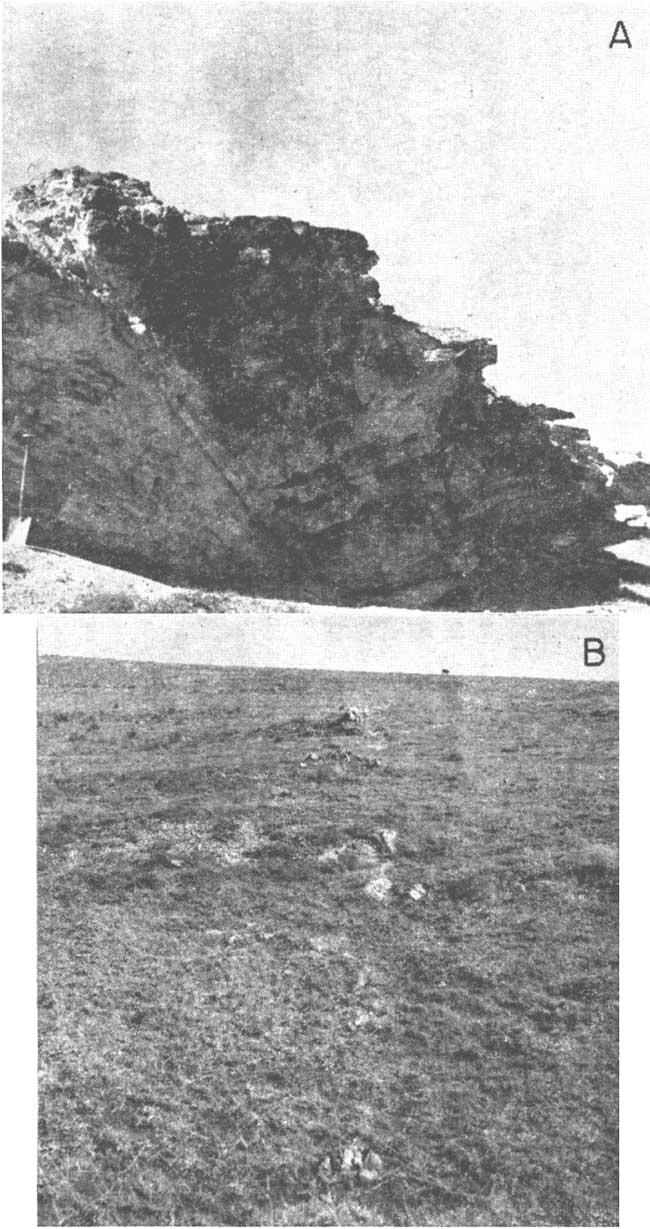
Plate 7--A, Fault in Niobrara formation in sec. 11, T. 14 S., R. 32 W., showing gentle folding associated with faulting, Folds to right of fault are on downthrown side and have axes trending at a small angle to strike of fault. Fold at left of fault has been caused by drag on downthrown side of fault. B, Fault line in Pierre shale in sec. 33, T> 13 S., R. 35 W. Fault plane dips to right probably at 45°. Difference in nature of shale on opposite sides of fault is reflected in color of soil and in vegetation.
No dominant trend of the faults was observed. They are generally short; the longest fault traced was less than 3.5 miles long and even that may be a series of shorter en echelon faults. Many faults are only a few hundred feet long, and almost all are less than a mile in length.
Associated with the faults are folds (Pl. 7A) and joints. The folds are of three distinct types: (1) folds dipping as much as 15° on the flank whose fold axes trend parallel or at small angles to the fault strike; (2) smaller folds whose axes trend at large angles to the strike of the fault plane; and (3) minor folds adjacent to the fault. Jointing is best developed parallel to and, to a lesser extent, at right angles to the fault. The larger folds and the parallel joints are an aid to mapping because they indicate the location, dip, and trend of the fault so that definitive evidence of faulting can be found. In a few places the trace of the fault on the surface could be recognized by differences between the soil and vegetation on one side and those on the opposite side of the fault (Pl. 7B).
The mechanics of the folding and faulting are not clearly understood, but seemingly the faults are tensional and probably are related to the relief of the compressive forces that created the larger folds. The set of folds normal to the fault is probably the result of differential drag along the fault plane. The smaller folds result from the drag of the opposite sides of the fault. The joints parallel to the fault are more closely spaced adjacent to the fault, and the spacing increases with the distance from the fault. These probably are release fractures resulting from the same tension that caused the fault. Another set of joints commonly is developed at right angles to the fault plane; their function in the mechanics of the faulting is not known.
The faulting and associated folding are intense in some small areas where individual faults commonly intersect nearly at right angles. The faulting has broken the Cretaceous rocks into a complex series of tilted blocks, some of which can be identified its typical grabens and intervening horsts. The random orientation of the faults seems to discount the idea of their association with major structural trends, nor was evidence observed of faulting by surficial slumping. Differential compaction of the underlying sediments such as that suggested by Twenhofel (1925) or local subsidence as a result of solution of underlying beds (Russell, 1929) are possible causes of the fracturing. Another possibility is suggested by the greater number of faults in Logan County that dip outward from the major stream valleys; the weak Cretaceous shale and shaly chalk may have bulged upward beneath the large valleys from which great thicknesses of rock were removed by erosion. The anticline caused by the relief of the rocks might produce sufficient tensional force to rupture the Cretaceous beds. Upward bulges of weak shales resulting in anticlines of nontectonic origin have been reported in Great Britain (Hollingsworth, Taylor, and Kellaway, 1944).
The various fractures may permit small accumulations of ground water, especially in areas where it is difficult to obtain supplies for livestock from other sources. For this reason the occurrence of faults and joints in the region is of considerable practical significance.
Prev Page--Geography || Next Page--Formations
Kansas Geological Survey, Geology
Placed on web Dec. 10, 2007; originally published May, 1958.
Comments to webadmin@kgs.ku.edu
The URL for this page is http://www.kgs.ku.edu/General/Geology/Logan/04_geol.html