![]()
Prev Page--Table of Contents || Next Page--Geography
Introduction
Purpose and Scope of Investigation
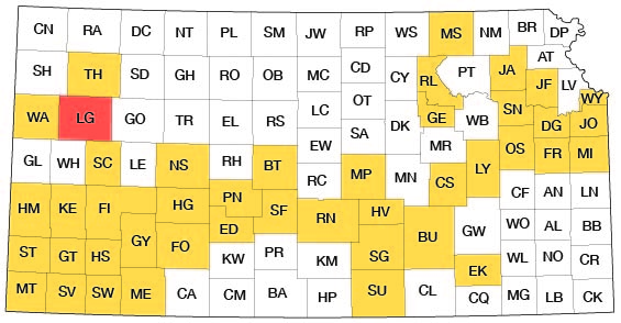
The investigation upon which this report is based was begun in June 1954 as part of a program of ground-water studies in Kansas by the United States Geological Survey and the State Geological Survey of Kansas in cooperation with the Division of Sanitation of the Kansas State Board of Health and the Division of Water Resources of the Kansas State Board of Agriculture. Many similar investigations have been completed since the program began in 1937, and several are now being made in other areas in Kansas (Fig 1).
Fig. 1--Index map of Kansas showing area described in this report and areas covered by other online geologic reports, as of Dec. 2007. For additional information, please visit the KGS Geologic Maps of Kansas Page.
Ground water is one of the principal mineral resources of Logan County, as well as of most of western Kansas. All public supplies and nearly all domestic and livestock water supplies are obtained from wells. Most of the irrigation wells in the county have been drilled since 1945, and the use of ground water for irrigation, especially in the upland areas, probably will increase. An adequate understanding of the quantity and quality of the available supply, of where additional supplies can be obtained, and of what measures may be necessary to safeguard their continuance is needed.
Location and Extent of Area
Logan County is in the third tier of counties south of the northern border of Kansas and is the second county east of the western border (Fig. 1). It is bounded on the west by Wallace County, on the south by Wichita and Scott Counties, on the east by Gove County, and on the north by Thomas and Sherman Counties. It contains 30 townships from T. 11 S. to T. 15 S. and from R. 32 W. to R. 37 W. and has an area of 1,073 square miles.
Previous Investigations
A detailed study of the areal geology and ground-water resources of Logan County has not been undertaken previously, but specific reference to the area has been made in many earlier geological and hydrological reports.
In 1892 Willard reported barometric fluctuations in a well at Winona. Robert Hay (1895) mentioned the occurrence and moisture absorption of an "agatized mortar bed" at McAllaster (p. 553) and indicated that the Pierre shale extends east to the middle of Logan County (p. 573). Haworth (1897) described the physiography of western Kansas and discussed the origin of the High Plains, described the physical properties of the Tertiary rocks in western Kansas (1897a), and reported on the geology of the underground water in western Kansas (1897b). In his reports on the utilization of the High Plains, Johnson (1901, 1902) referred to the source, availability, and use of ground water in western Kansas. Darton (1905) described the geology and ground-water resources of the central Great Plains, in a report in which he briefly referred to deep test holes and wells drilled in Logan County (p. 306-307), and a report by Parker (1911) contained the analyses of samples of ground water (p. 127) and the analyses of two samples of surface water collected at sites in Logan County (p. 204). In a special report on well waters in Kansas, Haworth (1913) devoted a chapter to the Tertiary area of western Kansas (p. 57-68). Lupton, Lee, and Van Burgh (1922) reported on the Elkader dome, the Hell Creek structure, and the Twin Buttes anticline in Logan County. Russell (1929) studied the rocks of the Niobrara formation in Logan, Gove, and Trego Counties and reported on the usefulness of bentonite layers in interpreting the stratigraphy. Elias (1931), in a bulletin on the geology of Wallace County, made many references to the geology of Logan County and described a geologic section of the Pierre shale east of McAllaster Buttes (p. 63). Lee (1940, pl. 7) gave a geologic section across Logan County depicting the structure of the rocks of Mississippian age. A report (U. S. Geological Survey, 1944) on water levels and artesian pressures in the United States in 1942 briefly outlined the observation-well program in Logan County (p. 137-138). Similar reports that contain water-level measurements for several wells in Logan County for the years 1943 through 1955 have been published. A cross section by Collins (1947) contains two well logs in Logan County. In 1951 and 1952 a detailed geologic and hydrologic investigation was made of the Ladder Creek area in Kansas, which contains the part of Logan County south of Smoky Hill River (Bradley and Johnson, 19571). Merriam and Frye (1954), reporting on the Cenozoic of western Kansas, presented maps (pl. 1, 2) showing the areal geology, pre-Cenozoic geology, and pre-Cenozoic topography of part of Logan County.
Reports of investigations of the geology and ground-water resources made as part of a program of ground-water investigations in Kansas include, among others, those on Thomas County (Frye, 1945), Scott County (Waite, 1947), Lane County (Prescott, 1951), Sherman County (Prescott, 1953), and Wichita and Greeley Counties (Prescott, Branch, and Wilson, 1954).
Methods of Investigation
Data for this report were collected during the summers of 1954 and 1955. Records were collected on 276 wells; most were measured with a steel tape to determine the depth of the well and the depth to water. Well owners and drillers were interviewed regarding yield and drawdown of wells and the character of the water-bearing materials. Four aquifer tests using public-supply and irrigation wells were made to determine the permeability of the Ogallala formation. Chemical analyses of samples of water from 42 wells and 4 streams were used to relate the chemical character of each water to its geologic source.
The areal geology was mapped and studied in regard to its influence on the occurrence and movement of ground water. The nature of the subsurface materials was determined by the drilling of 28 test holes and by microscopic examination of the drill cuttings. The altitude of the surface at the test holes and wells was determined by plane table and alidade. The altitude of the Tertiary-Cretaceous contact was determined by altimeter at several exposures.
The wells and test holes shown on Plates 1 and 2 were located by automobile odometer and aerial photographs. The base map was prepared from a county map published by the Soil Conservation Service of the U. S. Department of Agriculture.
Well-numbering System
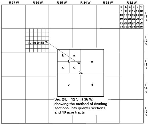
The well and test-hole numbers used in this report give the location of wells according to General Land Office surveys and in the following sequence: township, range, section, quarter section or 160-acre tract, and quarter-quarter section or 40-acre tract (Fig. 2). The 160-acre and 40-acre tracts are designated a, b, c, or d in a counterclockwise direction starting in the northeast quarter. If two or more wells are within a 40-acre tract, the wells are numbered serially beginning with the first well measured.
Fig. 2--Map of Logan County illustrating well-numbering system used in this report.
Acknowledgments
Many residents of Logan County gave permission to inventory their wells and supplied helpful information. Special thanks are given to Horace Holmes, James Ahrens, and officials of the cities of Winona and Oakley who permitted aquifer tests to be made using their wells, and to Marvin Becker who permitted the logging of a deep well to the Dakota formation. The following drillers provided logs of wells and test holes and other information on wells in the county: Struckoff Brothers, Grinnell; C. A. Robbin, Norton; Wesley Weishaar, Scott City; and John Heim, Dorrance. E. Wayne Brenn of the Soil Conservation Service, U. S. Department of Agriculture, and his staff aided in the collection of information and outlined the ground-water needs of residents of the county.
Assistance during field work was given by the following personnel of the U. S. Geological Survey or the State Geological Survey of Kansas: G. J. Stramel, William Gellinger, and E. L. and Carrie Reavis.
The manuscript for this report has been critically reviewed by several members of the Federal and State Geological Surveys; by Robert V. Smrha, Chief Engineer, and George S. Knapp, Engineer, of the Division of Water Resources of the Kansas State Board of Agriculture; and by Dwight F. Metzler, Director, and W. 0. Hilton, Geologist, of the Division of Sanitation of the Kansas State Board of Health.
Prev Page--Table of Contents || Next Page--Geography
Kansas Geological Survey, Geology
Placed on web Dec. 10, 2007; originally published May, 1958.
Comments to webadmin@kgs.ku.edu
The URL for this page is http://www.kgs.ku.edu/General/Geology/Logan/02_intro.html