![]()
Prev Page--Paleozoic and Cretaceous || Next Page--Wells and Springs
Water-bearing Formations, continued
Tertiary System
Pliocene Series
Ogallala Formation
Character--The Ogallala formation is composed of structureless silt and fine sand, together with some coarse sand and gravel, and ranges in color from buff to gray to white. The coarser sediments are present at all horizons but are most prominent in the lower part of the formation, the part that yields water most freely to wells.
Sand constitutes the principal material of the Ogallala formation and ranges in texture from fine- to coarse-grained, some of the coarser material containing scattered pebbles and thin beds of pebbles. The pebbles and grains are composed chiefly of granite, but there are a few pebbles of chert, limestone, and basic igneous rock. Quartz and feldspar generally make up about 95 percent of the mineral content of the sediments.
The finer materials of the Ogallala are composed chiefly of silt and generally contain only minor amounts of clay. Lenses or beds of sandy silt occur in all parts of the formation but principally in the upper part. The color of the silt ranges from gray to buff to light tan.
The gravels of the Ogallala comprise mainly pebbles of limestone sandstone, and ironstone, but also contain pebbles of quartz and quartzite. The coarse gravel near the base of the Ogallala in the Arkansas valley in Ford County comprises mainly water-worn pellets of Greenhorn limestone but contains some pebbles of sandstone and ironstone that probably were derived from the Dakota formation. The occurrence of pebbles of this type indicates that locally at least some of the Ogallala sediments were derived from the erosion of Cretaceous bedrock in nearby areas. Smith (1940, pp. 42, 43) described two distinct facies of gravel in the Ogallala formation one composed principally of sandstone, ironstone and quartzite, and the other made up mainly of crystalline igneous and metamorphic rocks. The former facies occurs at the base of the formation and the latter is widespread along the Arkansas valley in outcrops above the base of the formation. The sandstone-ironstone-quartzite facies is composed of material similar to that found in the Dakota formation and other Cretaceous formations; whereas, the granite facies that occurs above the base of the formation is composed of granite, feldspar, quartzite, quartz, felsite and other crystalline igneous and metamorphic rocks.
The Ogallala formation is characterized by lenticular bedding; thus, individual beds of sand or gravel are not continuous over wide areas, but generally are discontinuous lenses that may grade laterally into finer materials such as silt or clay, in some places within relatively short distances. The deposits range from those that exhibit definite bedding to those that show no bedding whatever. The structureless layers are commonly found in the upper part of the formation, are rather fine-grained, and contain some silt and small amounts of clay and lime. Irregular limy concretions are abundant in these layers, typical exposures of which occur in the bluffs on the north side of U.S. Highway 154, about one-half mile east of Fort Dodge. The color of this structureless part of the Ogallala ranges from gray to buff to light tan.
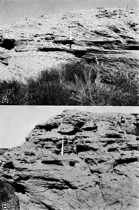
In many places the deposits are consolidated by calcium carbonate, forming beds of caliche. In some places the cemented beds resemble true limestone; elsewhere they may consist of sand and pebbles imbedded in a lime matrix. The cemented beds of the Ogallala have long been called "mortar beds," and in many places the "mortar beds" are highly cross-bedded (pl. 15). Cemented beds occur in the Ogallala at many places, but are most common in the upper part of the formation.
Plate 15--A, Typical "mortar bed" of the Ogallala formation showing the cross-bedded structure. On the north side of Arkansas river about 5 miles west of Dodge City in the NW corner sec. 25, T. 26 S., R. 25 W. B, Closer view of the same exposure showing the pitted character of the weathered surface.
The character of the Ogallala formation as revealed by drilling is illustrated by the logs of wells and test holes, pages 206 to 243. Although some of the individual beds have been described in the logs as clay, only minor amounts of clay are known to occur in the Ogallala formation. Some of the beds of silt are described by drillers as sand or clay or as combinations of both, and some beds of different texture are described simply as sand. The finer sands, sandy silts, and limy clays have been lumped together and called "magnesium and clay" by some drillers. The term "magnesia rock" appears frequently in drillers' logs and generally implies a hard, dense, lime-cemented bed. The terms "gyp," "gyp and sand," and "gyp rock" also have been used by some drillers in describing the more resistant lime-cemented beds encountered in the Ogallala. The upper unsaturated part of the formation consisting of fine sand, sandy silt, and some clay is described by some drillers as "dry sand" or as "fine packed sand." When coarser grains are imbedded in the matrix the material has been described by some as "coarse packed sand." The terms "sand rock" and "cemented sand" given in some of the drillers' logs refer to beds of sand and gravel that have been more or less cemented with calcium carbonate.
Subdivisions--In much of western Kansas the top of the Ogallala formation is formed by the top of the "Algal limestone," which marks the top of the middle Pliocene (Elms, 1931, pp. 136-143; Smith, 1940, pp. 44-46; and Frye and Hibbard, 1941, pp. 404, 405). In the Meade basin adjoining the southwestern corner of Ford County, however, beds that have yielded upper Pliocene fossils (Hibbard, 1938, p. 241) occur above the middle Pliocene beds. Smith (1940, p. 95) named these beds the Rexroad formation, from exposures on Rexroad ranch in south-central Meade County from which Hibbard collected the Rexroad fauna. Frye and Hibbard (1941, p. 407), however, have pointed out that in the central part of the Meade basin these beds conformably overlie middle Pliocene deposits with no apparent break, and generally are indistinguishable lithologically from the middle Pliocene deposits of that area. For these reasons they have classified the deposits as the Rexroad member of the Ogallala formation. Deposits of sand and gravel and interbedded silt and clay, encountered in test drilling in southern Ford County, at the northern end of the Meade basin, occur at the same stratigraphic position as the Rexroad member of Meade County and may be equivalent, in age. Fresh-water mollusks from some of these beds (described below) indicate, however, that some of the beds may be of Pleistocene age.
Distribution and thickness--The Ogallala formation is exposed at or near the surface over most of the county north of Arkansas River in Ford County, the top of the formation being essentially the surface of the High plains (pl. 1). No exposures have been noted south of Arkansas River where the Ogallala formation is mantled by the Kingsdown silt. In certain areas deposits of dune sand overlie both the Kingsdown and the Ogallala. In much of the Arkansas valley west of the city of Ford, the Ogallala formation is covered with alluvium. East of Ford the Ogallala has been largely removed in the Arkansas valley, and the alluvium rests unconformably on the Dakota formation. The Ogallala is thin or entirely absent in the north-central part of the county in places where dissecting streams such as Sawlog Creek and its tributaries have cut beneath the plains surface into the underlying Cretaceous bedrock.
The Ogallala formation ranges in thickness from a few feet to about 250 feet, and its maximum thickness is probably attained under the uplands north and west of Dodge City. The maximum thickness of the formation was not encountered in any of the test holes but is inferred from the geologic cross-sections (pl. 15). The thickness of the Ogallala in the 21 test holes drilled during the investigation ranged from about 22 feet in test hole 1 in the northeastern part of the county to 150 feet in test hole 6 in the Arkansas valley 1 mile west of Dodge City. The test drilling indicated that the Ogallala becomes progressively thinner toward the east and northeast.
Origin--As pointed out under Geologic history the sediments comprising the Ogallala formation were deposited by heavily-laden streams that flowed from the Rocky Mountain region. The pebbles of igneous and metamorphic rocks in the gravels and abundance of quartz and feldspar in the sands are believed to have been derived from the Rocky Mountains. Locally, the basal gravels also contain some reworked material from less distant sources, including water-worn fragments of Greenhorn limestone and pebbles of sandstone and ironstone from the Dakota formation. Much of this material probably was derived from Cretaceous rocks in or just west of the county.
The origin of the abundant calcium carbonate in the Ogallala has been discussed by Smith (1940, p. 79) who concluded that-
"the transported calcareous matter in the Ogallala originated mainly, if not only, in the Rocky Mountain area from weathering of Paleozoic limestone and calcic minerals in the crystalline rocks. ... Additional lime may have been provided also by weathering in situ after deposition."
Smith also suggested that the silt and clay of the Ogallala probably were derived from soils and weathering products in the mountain area and to a lesser extent from the wearing down of coarser materials in transit. The coarser beds of sand and gravel represent channel deposits and the finer materials represent floodwater deposits formed by the overflow of shallow channels that perhaps approached the character of sheet-floods locally.
The sandstone and conglomerate in the Ogallala represent beds of sand and gravel that have been cemented by underground waters. Deposits of sandy silt, cemented with calcium carbonate, and often referred to as caliche, probably are a product of surficial calichification formed during a relatively long pause in deposition, at a time when streams had shifted to some other part of the region. The concentration of calcium carbonate, in the soil zone, by surficial processes was accomplished during such periods, and was halted by recurring periods of deposition to give rise to caliche zones at varying 4 intervals throughout the formation.
There are at least 3 different hypotheses to account for the origin of the capping limestone at the top of the Ogallala. Elias (1931, p. 41) suggested a lacustrine origin and stated that the limestone was deposited on the nearly flat bottom of a very large and very shallow lake at the close of Ogallala time.
Gould and Lonsdale (1926, pp. 29-33) advanced the caliche hypothesis for the capping limestone in the Oklahoma area. Smith (1940, pp. 91, 92) suggested that:
"Possibly both hypotheses are partly right, and both caliche and lacustrine limestone are present in different parts of the region, possibly gradational into one another."
Theis (1936) suggested that the capping limestone was deposited, either by inorganic or by organic agencies, in unconnected pools that resulted from the flooding of shallow depressions by a rising water table under conditions of a cooling climate and probably increasing precipitation associated with the approach of Pleistocene time. For a much more detailed discussion of the origin of the Ogallala formation the reader is referred to the report by Smith (1940, pp. 77-94).
Age and correlation--The Ogallala formation originally was named and described by Darton (1899, pp. 732, 734) and its age was given as hate Tertiary, or Pliocene (?). Darton later (1920, p. 6) designated the type locality near Ogallala station in western Nebraska. The conclusions of later workers regarding the age and correlation of the Ogallala formation in western Kansas have been summarized by Smith (1940, pp. 73-74).
The Ogallala formation is classified as Pliocene by the United States Geological Survey. Smith (1940, pp. 75, 76) concluded that the Ogallala of southwestern Kansas, insofar as it is represented by exposures at the surface, may be assigned to middle Pliocene age. According to this definition, the top of the Ogallala formation is marked by the top of the capping limestone. Smith considered the overlying beds that have yielded upper Pliocene fossils as a separate formation, which he called the Rexroad formation (see p. 95). For reasons stated earlier all of the deposits below the Kingsdown silt and above the Cretaceous bedrock are included in the Ogallala formation, the upper (late Pliocene) part of the formation being segregated as the Rexroad member.
Few vertebrate fossils have been collected from the Ogallala formation in Ford County. A horse tooth that had been recovered from the Ogallala at a depth of 113 feet during the drilling of an irrigation well (402, see log 61) in the SW 1/4 sec. 6, T. 27 S., R. 26 W., was given by me to C.W. Hibbard who identified it as a right molar of Pliohippus cf. interpolatus. Schoff (1939, pp. 61, 62) reported that large collections of vertebrate remains taken from excavations in the vicinity of Optima and Guymon, Texas County, Oklahoma, were considered by Stovall to be middle Pliocene in age. According to Schoff, the fossils were found in the upper 100 feet of the formation.
Elias (1932, pp. 333-340) described fossil grass and hackberry seeds that were collected mostly from typical "mortar beds" of the Ogallala formation. In a later paper (Chancy and Elias, 1936) it was shown that certain of the fossil seeds are of widespread occurrence and have a short vertical range, making them useful as guide fossils. Fossil grass and hackberry seeds were collected by me from the Ogallala formation in Ford County, notably on the east side of Five-Mile Creek in the NW 1/4 NW 1/4 sec. 30, T. 25 S., R. 23 W., and on the east side of Spring Creek in the SW 1/4 sec. 28, T. 25 5., R. 23 W. In both localities the seeds were collected from hard massive layers of cemented grit and coarse sand from 8 to 10 feet in thickness that formed abrupt benches along the sides of the valleys. At the first locality mentioned, the seeds were collected from beds about 15 feet above the top of the Dakota formation. From comparisons with forms described by Elias, the grass seeds are believed to he Biorbia rugosa and the hackberry seeds are believed to be Celtis willistoni.
The following fresh-water mollusks recovered from a test hole in the Rexroad member of the Ogallala formation were identified by Dr. Calvin Goodrich of the University of Michigan.
| Depth below land surface, in feet |
Fresh-water mollusks from test hole 21, in the NW corner sec. 36, T. 28 S., R. 26 W. |
|---|---|
| 132-135 | Gyraulus parvus (Say) |
| 135-138 | Gyraulus parvus (Say) |
| 138-151 | Gyraulus parvus (Say) |
| 151-157 | Gyraulus parvus (Say), 1 specimen; 1 fragment apparently of a gastropod; 1 fragment apparently of bone; and 1 unidentified fragment. |
| 157-164 | Gyraulus parvus (Say), 1 specimen, and fragments possibly of a more mature specimen than this, or of a very young specimen of Helisoma. |
| 167-170 | Fragments of a small gastropod, possibly of the genus Lymnaea, certainly not of a shell with flattened spire such as Gyraulus or Helisoma. |
These forms have been described from the Meade formation of Pleistocene age which overlies the Rexroad member in Meade County (Frye and Hibbard, 1941, pp. 413-415) so it is possible that some of the beds below the Kingsdown silt encountered in test holes in southwestern Ford County are of Pleistocene age. Due to the fact that beds believed to be equivalent to the Rexroad member of the Ogallala formation and of the Meade formation are nowhere exposed in Ford County; however, it is impossible to make any definite correlation on the basis of the data available.
Water supply--In Ford County, as in many other parts of the High Plains, the Ogallala formation is the most important water-bearing formation. Most of the domestic and stock wells on the uplands, many of the irrigation wells, and all of the large industrial and public-supply wells derive water from the Ogallala formation. Even in the Arkansas valley, where water is available at shallow depth in the alluvium, many well owners have drilled their wells deeper to tap the Ogallala formation. All of the irrigation wells south of the Arkansas valley in Ford County obtain water from this formation.
The yields of wells tapping the Ogallala range from several gallons a minute from small domestic and stock wells to about 1,700 gallons a minute for some of the large industrial wells (369, 370 and 371). The largest yields from the Ogallala are obtained from the coarser materials, generally in the lower part of the formation.
The beds of the Ogallala formation once extended from the Rocky Mountains eastward to perhaps as far as the eastern third of Kansas, but they have been removed by erosion from much of the territory they once occupied. A much greater thickness of the formation may have been saturated at one time, but dissection by streams such as Arkansas River and Sawlog Creek have cut below the zone of saturation and are draining part of the water from the formation.
In recent years there has been an increase in the number of wells tapping the Ogallala formation in the Arkansas valley in Ford County, largely as a result of increased demands for irrigation and industrial supplies.
The water from the Ogallala is hard. The analyses of typical waters from the Ogallala formation are shown in figure 20. Analyses of 45 samples of water collected from the Ogallala formation indicate that the hardness ranged from 171 to 276 parts per million and averages about 228 parts. The analyses also indicate that the amount of iron contained in these samples of water from the Ogallala ranges from 0.0 to 4.7 parts per million, but about half had less than 0.1 part per million. The fluoride content of these 45 samples ranged from 0.1 to 3.6 parts per million--28 samples of water from this group contained 0.5 parts per million or less of fluoride and 13 contained more than 1 part. The analyses indicate that the water from the Ogallala is well within the suggested safe limits for use in irrigation. The water in the Ogallala is generally softer than the water in the overlying alluvium.
Quaternary System
Kingsdown Silt
Character--The Kingsdown silt consists mainly of light buff to brownish silt, clay, and fine sand, but contains some light-colored sand and gravel at the bottom, and at the top it grades upward into loess. Some of the beds contain small calcareous nodules. Probably a part of the silt is reworked loess. Most of the beds are even-bedded--some of the beds being finely and evenly laminated.
In most places the contact between the lower water-laid silt, of the Kingsdown and the overlying loess is indistinguishable, making it difficult to differentiate between them. For this reason the Kingsdown silt, as redefined by Frye and Hibbard (1941, pp. 419, 420), locally includes loess at the top.
In Ford County the character of the Kingsdown silt is best revealed from the cuttings obtained from test drilling (see logs of test holes 10, 11, 12, 13, 14, 15, 16, 17, 18, 19, 20, and 21). The base of the formation is not exposed in Ford County, but the upper part of the formation is exposed along Mulberry and Rattlesnake creeks and their tributaries. On the basis of samples from test holes, the Kingsdown silt may be described as being made up predominantly of soft light brown to reddish-brown to light gray limy silt, but it also contains a few nodules and streaks of lime and, locally at the base, a few beds of sand and gravel. The Kingsdown silt drills rather easily as there are no hard cemented beds to impede the progress of the drill.
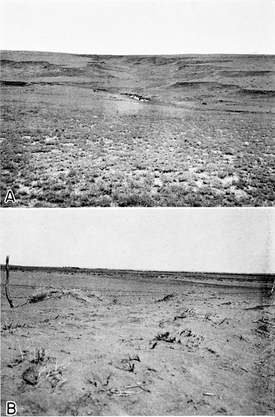
Distribution and thickness--The areal extent of the Kingsdown silt in Ford County is shown in plate 1. The Kingsdown is widely exposed south of the Arkansas valley, the best exposures occurring along Mulberry Creek and especially along the headwaters of Rattlesnake Creek and its tributaries in the vicinity of Bucklin. Because the Kingsdown silt is relatively soft, it is commonly eroded to form a semi-badland type of topography, with numerous branching, closely spaced gullies (pl. 16A). Few exposures of the Kingsdown were found north of the Arkansas valley, and it is believed to occur only in isolated patches on the upland in this part of the county.
Plate 16--A, Typical view of gulley erosion in the Kingsdown silt. Southwest of Ford in the SW SE sec. 34, T. 28 S., R. 23 W. B, Drifting sand in the sand hills bordering the south side of the Arkansas valley. South of Howell, along east side of sec. 31, T. 26 S., R. 26 W.
The reasons for the thinness of the Kingsdown north of the Arkansas valley are puzzling, but it is believed that this anomalous condition may be traceable to related tectonic causes. Smith (1940, p. 115) pointed out that drainage conditions at the time of deposition were undoubtedly different from those of the present and that, ultimately, deposition must have been due to a flattening or actual reversal of stream gradients as a result of crustal warping. He added that it was significant that the Kingsdown occurs in an area where:
(1) The general land surface is higher south of the Arkansas valley than on the north; (2) Arkansas River begins its swing northeastward into the very anomalous Great bend; (3) the Arkansas is perched as much as 180 feet higher than its tributary valleys, Buckner creek, Pawnee river and Walnut creek, on the north; and (4) the outer Arkansas valley and the sand-hill belt to the west are abnormally wide.
He further suggested that the inferred differential warping began possibly before the deposition of the Kingsdown, and continued during and after that event. As evidence of post-Kingsdown movement Smith referred to the broad arching of the depositional surface along an east-west axis as shown by an examination of the topographic maps.
The localization of the Kingsdown silt, in southern Ford County doubtless is related to the abnormal breadth of the outer valley of Arkansas River in southeastern Kearny County, southern Finney County, and central Gray County as shown by the width of the sand-hill belt. Smith (1940, p. 138) suggested that this broad belt was formed probably by areal subsidence, continuous with but less regular in outline than that north of the river, and that this subsidence may have been a factor in leading to the deposition of the Rexroad or Kingsdown or both. It seems plausible that this subsidence and the deposition of the Kingsdown may be related to similar tectonic causes. Just prior to the deposition of the Kingsdown there was renewed downward movement of the structural trough in which the Rexroad and early Pleistocene sediments had been deposited. The effect of such downward movement was to trap the sediment of any through-flowing streams and to increase the quantity of material carried in from surrounding areas toward the middle of the trough.
According to Smith (1940. p. 112), the best exposures of the Kingsdown "formation" are found along Bluff Creek and its tributaries in Clark County, Kansas. A 5-foot bed of clean, even-bedded volcanic ash is also described as occurring near the base of the Kingsdown in the vicinity of an exposure in sec. 13, T. 30 S., B. 23 W.
Only the upper part of the formation is exposed in Ford County, but the entire formation was penetrated in 12 test holes (see logs 10-21) and in most of the wells south of the Arkansas valley. The thickness of the Kingsdown ranges from about 55 feet in test hole 12 to 123 feet in test hole 11, and appears to be the greatest beneath the divides north and south of Mulberry Creek. In the southwestern corner of the county the Kingsdown ranges in thickness from about 90 to 118 feet, (logs 19, 20 and 21) and was found to be 108 feet thick in test hole 15, four miles south and one mile west of Kingsdown. It was found to be 107.5 feet thick in the city well (467) at Bucklin (log 70) and 110 feet thick in an oil test southeast of Bucklin (log 71) in the NE 1/4 sec. 22, T. 29 S., R. 21 W.
Origin--The origin of the Kingsdown silt has been discussed under Geologic history, page 39. Probably a part of the material comprising these deposits is reworked eolian loess, and a part of the basal sand and gravel was undoubtedly derived from erosion of the Ogallala. Lacustrine deposition is suggested by the finely and evenly-bedded lamination. The cause of deposition probably is related to differential downwarping with a resultant flattening or actual reversal of stream gradients.
Age and correlation--Smith (1940, p. 111-112) suggested the name "Kingsdown formation" as a revival of Cragin's loosely-defined "Kingsdown marl" (1896), of supposed late Pliocene age, and redefined the term to include beds of Pleistocene age only. He also points out that it was included in the "Tertiary man" as mapped by Hay. Because it is composed largely of silt it was called the Kingsdown silt by Frye and Hibbard (1941, p. 419), who included the loess overlying the water-laid deposits as the upper part of the formation; this usage is followed in the present report. The loess may have been deposited during the Recent epoch.
The Kingsdown silt has yielded very few fossils, and so far as known, none have been collected from these deposits in Ford County. Hay (1917, p. 42) reported that Cragin found Elephas columbi along the upper part of Bluff Creek, in Clark County; and Williston (1897, p. 303) reported teeth of Equus occidentalis from Bluff Creek, but no details of the location are given. Smith (1940, p. 114) reported that Hibbard found one vertebra of Bison in the Stephenson ranch section in sec. 13, T. 30 S., R. 23 W in Clark County. Hibbard states (Frye and Hibbard, 1941, p. 420):
"The only fossils recovered from the formation, Taxidea taxus (Schreber), Cynomus ludovicianus Ord, and Bison bison Linneaus, are identical with forms living ... during the Recent epoch."
Water supply--The Kingsdown silt is composed mainly of relatively impervious material that yields little or no water; moreover, most of the formation lies above the water table. The sand and gravel near the base of the formation might contain water in places where they lie below the water table. It is more likely, however, that the saturated deposits of the underlying Rexroad member of the Ogallala constitute the principal source of water to wells in the southern part of Ford County. As the formation consists mainly of silt overlain by loess, probably little or none of the rain falling upon its surface percolates downward to the water table.
Dune sand
Dune sand occurs mainly in a belt of varying width along the south side of the Arkansas River in Ford County, but is found also in an area of several square miles on the north side of the river, north of Ford, and in another area several square miles in extent in the southwestern part of the county (pl. 1). The thickness of the dune sand ranges from a few feet to a maximum of 70 feet. The dunes, except where reopened by recent blowouts, are old and well stabilized, and may date back well into the Pleistocene. The dunes on the south side of the river were derived at least in part from the terrace deposits. In places the soil zone is thin and attempts at cultivation have stripped the protective cover allowing the upper surface to be subjected to renewed wind action (pl. 16B). Smith (1940, pp. 165-168) pointed out that the present river floodplains along the Arkansas valley could not have been a source for the dune sand, contrary to the assumptions of previous writers (Darton, 1916, p. 42; 1920, p. 3), because no movement of sand from the channel toward the dune belt is to be observed. He contends further that few if any dunes of any consequence are to be found either on the floodplain or the lowest terrace, and that the dune belt is far too wide to have been supplied from the present valley unless there was extensive movement of migratory dunes.
He suggests that older and higher terraces, as yet unrecognized, or the sands of older formations, including the Kingsdown and the Ogallala, may have been the source or sources of dune-building sand.
The dunes on the north side of Arkansas River, north of Ford, may have been derived from the underlying Ogallala, although any contribution from this formation would necessarily be limited to source areas where the cemented beds at the top were eroded away, so as to uncover the softer beds of sand below.
The dunes in southwestern Ford County are the northern extension of a much larger expanse of sand dunes in northeastern Meade County. Smith (1940, p. 167) suggested that the sand was derived, either wholly or in part, from the strand flats of a lake that may once have occupied a part of the Meade basin and that the sand probably came from the west. In connection with a discussion of the existence of a temporary lake that may have occupied an area northeast of Meade and west of Fowler after the close of Pleistocene time, Frye (1940, p. 14) pointed out that the sand dunes north of Fowler have the aspect of beach dunes.
Water supply--The dune sand lies above the water table nearly everywhere, and for this reason probably does not supply water directly to wells. The areas that are mantled with dune sand provide the opportunity for effective recharge to the underlying groundwater reservoir, because of the high porosity of the sand deposits as indicated by the relative absence of surface drainage in such areas. Probably a rather large percentage of the rain that falls on such areas moves downward to join the water table.
Terrace gravel
At many places along the south side of Arkansas River, deposits of fairly coarse gravel are found in a terrace about 15 to 25 feet above the level of the river, and averaging about 20 feet above. They were deposited by Arkansas River at some time during the Pleistocene when it was flowing at a higher level than at present. These Quaternary terrace deposits have been described by Smith (1938, 1940, p. 125, 126). The deposits range in thickness from a few feet to about 20 feet, and the material consists of beds of clean, unconsolidated, cross-bedded sand and lenticular beds of gravel. The terrace gravels are well exposed in several commercial pits on the south side of Arkansas River in the vicinity of Dodge City, the locations of which are shown on the geologic map (pl. 1). The terrace deposits were mapped with the alluvium in plate 1. According to Smith (1940, pp. 125, 126), the deposits are probably late Pleistocene in age on the basis of a few vertebrate fossils that have been recovered; and, because the terrace deposits are situated lower topographically than the Kingsdown, he suggests that they are younger than that formation.
The terrace deposits are not a source of water in Ford County because any water that they may have contained before the river became intrenched to its present level has since drained out.
Alluvium
Alluvium of late Quaternary age is found principally in the Arkansas valley and in the valleys of some of the other streams in Ford County, (pl. 1). Some of the streams are still in the process of downcutting so that there is little or no alluvium along the greater part of their courses in Ford County. Streams with little or no alluvium include Mulberry, Crooked and Rattlesnake Creeks south of the Arkansas valley, and Coon and Cow creeks in the northeastern part of the county.
The character of the alluvium is typical of stream-laid deposits and ranges in texture from silt to sand and coarse gravel. The youngest deposits consist largely of sand and silt deposited over the flood plain in time of flood or under normal conditions in the channel of the stream. Beneath the finer surface deposits are layers of sand and gravel slightly older but of similar origin. Possibly a part of the valley fill in some places is of late Pleistocene age, and represents the basal part of a cut and fill terrace deposit. The sand and gravel deposits are best developed in the alluvium of the Arkansas valley. The smaller valleys are partly filled with alluvium consisting mainly of silt and fine sand.
The thickness of the alluvium in the Arkansas valley in Ford County, as revealed by test drilling, ranges from about 15 feet in the eastern part of the county (logs 48 and 49) to about 40 feet in the central and western part of the county (logs 6, 7, 8, and 9). The alluvium is 33 to 42 feet thick along the south side of Arkansas River just east of Ford (logs 63, 64, 65). It is possible that in some places the alluvium in the Arkansas valley attains a thickness of 50 feet or more.
The alluvium is underlain by the Ogallala formation in most parts of the Arkansas valley, but near and east of Ford the alluvium rests unconformably on the Dakota formation.
Scanty data indicate that the thickness of the alluvium along Sawlog valley and some of its tributaries ranges from a few feet up to an estimated maximum of 25 or 30 feet.
The alluvial sand and gravel deposits are very permeable and yield large quantities of water to wells tapping them. In the Arkansas valley the alluvium is the source of supply for many irrigation, domestic, and stock wells. The yields of wells tapping the alluvium in the Arkansas valley range from a few gallons a minute to about 1,000 gallons a minute. The yields of wells in the smaller stream valleys generally are adequate for domestic and livestock purposes.
The hardness of 13 samples of ground water obtained from the alluvium ranges from 187 to 1,577 parts per million (fig. 20). The waters from alluvium were of two distinct types--differentiated by content of sulfate. Those low in sulfate, about half of those analyzed had less than 15 parts per million--are very similar in chemical character and mineral content to Ogallala waters. The others usually contain more than 300 parts of sulfate but have about the same bicarbonate content as the waters with low sulfate. Twelve of the 13 samples from the alluvium contained less than 0.15 parts per million of iron, but one sample contained 26 parts. The fluoride content of the samples of water from the alluvium ranged from 0.1 to 1.9 parts per million, and five of the samples contained more than 1.0 part.
Prev Page--Paleozoic and Cretaceous || Next Page--Wells and Springs
Kansas Geological Survey, Ford County Geohydrology
Web version April 2002. Original publication date Dec. 1942.
Comments to webadmin@kgs.ku.edu
The URL for this page is http://www.kgs.ku.edu/General/Geology/Ford/06_form2.html