![]()
Prev Page--Cenozoic || Next Page--Water Table
Ground Water
General Ground-water Conditions
Source
Ground water, or underground water, is the water that supplies springs and wells. In Ford County, ground water is derived almost entirely from precipitation in the form of rain or snow. Part of the water that falls as rain or snow is carried away by surface runoff and is lost to streams, part of it may evaporate or be absorbed by vegetation and transpired into the atmosphere. The part that escapes runoff, evaporation, and transpiration percolates slowly downward through the soil and underlying strata until it reaches the water table where it joins the body of ground water known as the zone of saturation. In the southern High Plains, several lines of evidence indicate that on an average only about half an inch of water a year escapes evaporation and transpiration to join the groundwater reservoir (Theis, Burleigh and Waite, 1935, pp. 1-4). In parts of Ford County where the surface is mantled by deposits of loess or silt of the Kingsdown, the amount of recharge may be less than the average given for the entire High Plains, but in parts of the sand hills the amount of recharge probably is considerably greater.
The ground water percolates slowly through the rocks in directions determined by the topography and geologic structure, until it is discharged eventually through springs or wells, through seepage into streams, or by evaporation and transpiration in bottom lands adjacent to the streams. Most of the water obtained from shallow wells and springs in Ford County is obtained largely from precipitation in the general vicinity, that is, in Ford County and adjacent areas. The water in the Dakota formation under Ford County, however, is derived from precipitation and small streams in the areas of outcrop, which are mainly in southwestern Kansas and southeastern Colorado at higher altitudes.
Some of the deeper rocks under Ford County contain highly mineralized water. Waters of this type have become brackish or salty by circulation through subterranean salt and gypsum deposits.
Occurrence
[For a detailed treatment of the occurrence of ground water, see Meinzer, O.E., The occurrence of ground water in the United States with a discussion of principles: U.S. Geol. Survey Water-Supply Paper 489, pp. 1-321, 110 figs., 31 pls., 1923. For a general discussion of the occurrence of ground water in Kansas, see Moore, R.C., Groundwater resources of Kansas: Kansas Geol. Survey Bull. 27, pp. 1-112, figs. 1-28, pls. 1-34.]
The rocks that form the crust of the earth are, in general, not solid throughout, but contain numerous open spaces, called voids or interstices, and it is in these spaces that water is found below the surface of the land and from which it is recovered in part through springs and wells. There are many kinds of rocks and they differ greatly in the number, size, shape, and arrangement of their interstices and hence in their water-holding capacities. 4he occurrence of ground water in any region, therefore, is determined by the geology of the region.
The interstices of rocks range in size from minute pores of microscopic dimensions to openings several inches in width and can be divided into two classes - primary and secondary. The primary or original interstices were formed contemporaneously with the formation of the rock; the secondary interstices were developed by processes that affected the rock after it had been formed. In Ford County the water-bearing rocks are all of sedimentary origin, and the openings that hold the water are: (1) the open spaces between the grains of the rocks; and (2) the joints, crevices, and open bedding planes which have resulted from fracturing of the rocks.
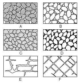
The amount of water that can be stored in any rock depends upon the porosity of the rock. Porosity is expressed quantitatively as the percentage of the total volume of rock that is occupied by interstices. When all its interstices are filled with water a rock is said to be saturated. In a saturated rock the porosity is practically the percentage of the total volume of the rock that is occupied by water. Several types of rock interstices and the relation of rock texture to porosity are shown in figure 5.
Figure 5--Diagram showing several types of rock interstices and the relation of rock texture to porosity: (A), well sorted sedimentary deposit having a high porosity; (B), poorly sorted sedimentary deposit having low porosity; (C), well-sorted sedimentary deposit consisting of pebbles that are themselves porous, so that the deposit as a whole has a very high porosity; (D), well-sorted sedimentary deposit whose porosity has been diminished by the deposition of mineral matter in the interstices; (E), rock rendered porous by solution; (F), rock rendered porous by fracturing. (After O.E. Meinzer.)
The amount of water a given rock can hold is determined by its porosity, but the amount of water that it may yield to wells is determined by its permeability. The permeability of a rock is its capacity for transmitting water under pressure, and is measured by the rate at which it will transmit water through a given cross section under a given difference of pressure per unit of distance. Certain dense clays and shales may have higher porosities than beds of coarse sand; but, because of the small size of their interstices, they may transmit no water under ordinary pressure; and, hence, under the incompetent force of gravity, they may be impermeable. Rocks differ greatly in their degree of permeability, according to the number and size of their interstices and the extent to which these interstices open into one another. In fine-grained rocks the movement of water under the force of gravity is retarded by the molecular attraction of individual grains; whereas, in a coarse, clean gravel with large openings that communicate freely with one another, the molecular attraction is not as great and more water becomes available to wells.
Water in Sand and Gravel
In Ford County unconsolidated deposits of sand and gravel are found in the alluvium in several of the stream valleys and in the Ogallala formation. The history of their deposition is given under Geologic History; their distribution, character, thickness, and water-yielding capacity are described under Water-bearing formations.
These stream deposits were subjected to the sorting action of water with the result that distinct beds of gravel, sand, silt, or clay were deposited. The source of material and degree of sorting determined the texture of this material, whether coarse or fine, some deposits being composed of clean well-sorted gravel, while in others finer materials predominate. In some poorly-sorted deposits, finer materials occupy the pore spaces between the larger grains reducing the effective porosity. Coarse, clean, well-sorted gravel or sand has a high porosity and high permeability. Properly constructed wells in material of this type yield large quantities of water.
Sand and gravel deposits in the alluvium of the Arkansas valley constitute one of the most important sources of groundwater in Ford County. The sand and gravel deposits of the Ogallala formation are equally important and constitute the principal source of water in the upland parts of the county and of many of the deeper wells in the valley. The alluvium and the Ogallala both furnish water to a great many domestic and stock wells and to many irrigation, municipal, and industrial wells. More than 200 irrigation wells in the valley are supplied with water from these deposits. The deposits of sand and gravel in the alluvium along smaller streams are not as thick as along Arkansas River, but, where present, yield small supplies of water to domestic and stock wells. The yields of wells ending in the alluvium of the Arkansas valley range from less than 5 to about 1,000 gallons a minute. The maximum yields obtainable from the alluvium are largely dependent upon the local character and thickness of the material and upon the construction of the well. Where the thickness of the alluvium is limited, some well owners have resorted to using a battery of wells interconnected to one pump in order to obtain larger yields (p. 104). The Ogallala supplies fewer wells in the valley than the alluvium, but yields as much as 1,700 gallons a minute to some industrial wells.
Water in Sandstone
The Dakota formation contains the only water-bearing sandstones tapped by wells in Ford County and ranks about third in importance, being surpassed only by the alluvium and the Ogallala formation.
The principal factors that determine the water-bearing properties of a sandstone are the size and uniformity of the grains, the degree of sorting, and the amount and character of cementation. The character of the Dakota formation underlying Ford County is variable. Some parts of the formation appear to be rather firmly cemented with iron oxide and other cementing material, and other parts consist of soft, friable, saccharroidal sandstone that readily disintegrates into very fine sand during ordinary drilling operations. Although there may be some water in joints and bedding planes in the sandstones of the Dakota formation, it is believed that the water is derived mainly from the pore spaces of the rock.
Beds of water-bearing sandstone are also present in the Cheyenne sandstone, which is known to underlie the Dakota formation in Ford County. This sandstone resembles the sandstones of the Dakota formation in composition and texture. Although the Cheyenne is not known to yield water to wells in Ford County it seems likely that it contains water and would doubtless yield water to any deep well that might be drilled to it. It is also probable that the water would he under some artesian head.
Most of the wells ending in the Dakota formation in Ford County tire used only for domestic and stock purposes; consequently, the maximum water-yielding capacity of the formation is not definitely known. The unused well of the Atchison, Topeka and Santa Fe Railway at Spearville (No. 34) was drilled into the Dakota formation, however; and, according to a test made by the owners, the well yielded about 80 gallons a minute with a drawdown of 8 feet. It is probable that this well would yield as much as 250 gallons a minute with greater drawdown. Many factors control the water-yielding capacity of the Dakota, chief among which are the thickness of the saturated rock penetrated, the physical properties of the sandstone, and the type of well construction. The sandstones of the Dakota formation in Ford County are fine-grained and do not yield water as freely as the Ogallala, but wells drilled to depths of about 200 feet in the northeastern part of the county might yield from 50 to 250 gallons a minute.
Volumetric core samples of the Dakota formation obtained from test holes in Ford County were analyzed in the hydrologic laboratory of the Federal Geological Survey. Mechanical analyses were made to determine the size and assortment of the grains; the porosity and moisture equivalent were determined so that specific yield could be computed; and the permeability was determined so that the rate of flow of water through the material could be approximated. The physical properties of the four cores of the Dakota formation are given in table 2.
Table 2--Physical properties of cored volumetric samples of the Dakota formation collected from test holes in Ford County, Kansas, by V.C. Fishel, U.S. Geological Survey.
| Test-hole No. on fig. 2 |
Lab. No. | Depth of core sample below land surface |
Mechanical analysis (percent by weight) | Apparent specific gravity |
Porosity (percent) |
Moisture equivalent (percent by vol.) (1) |
Coefficient of permeability (2) |
||||
|---|---|---|---|---|---|---|---|---|---|---|---|
| Medium sand (larger than 0.25 mm) |
Fine sand (0.25-0.125 mm) |
Very find sand (0.125-0.062 mm) |
Silt (0.062-0.005 mm) |
Clay (less than 0.005 mm) |
|||||||
| 8 | 2466 | 275 - 277 | 4.0 | 45.4 | 33.5 | 12.8 | 3.8 | 1.96 | 29.9 | 6.1 | 28 |
| 8 | 2467 | 291 - 292 | 0.7 | 72.3 | 19.4 | 4.2 | 2.7 | 1.87 | 30.8 | 7.5 | 4 |
| 4 | 2468 | 70 - 71 | 0.3 | 34.4 | 38.7 | 18.8 | 7.1 | 2.15 | 18.7 | 12.0 | 0.02 |
| 2 | 2469 | 134 - 136 | 0.2 | 34.9 | 43.5 | 15.7 | 5.3 | 2.16 | 22.5 | 13.9 | 0.007 |
1. The ratio of (1) the weight of water which the soil, after saturation, will retain against a centrifugal force 1,000 times the force of gravity, to (2) the weight of the soil when dry
2. The number of gallons of water a day, at 60 deg. F., that is conducted laterally through each mile of the water-bearing bed under investigation (measured at right angles to the direction of flow) for each foot of thickness of the bed, and for each foot
The 4 samples tested have very low permeabilities compared to the water-bearing sands in the alluvium and Ogallala formation, but appear to be representative of the sandstones of the Dakota formation in Ford County.
Water in Shale
It is probable that few wells in Ford County obtain supplies of water from shale. The areas in which wells might derive water supplies from shale are limited and generally are confined to localities in the north-central part of the county where the Ogallala is thin or entirely absent and the sandstones of the Dakota formation are not available to shallow wells. Shales are present in practically all of the bedrock formations in Ford County. The Greenhorn limestone is dominantly chalky shale the Pfeifer and Hartland members being made up largely of chalky shale with thin beds of limestone. The underlying Graneros shale contains thin-bedded lenticular sandstones and concretionary layers. The thin sandstone lenses might furnish small amounts of water locally to a well, but it is believed that the formation as a whole is rather barren of water. Any water obtained in the Graneros is apt to be of poor quality owing to the presence of considerable gypsum in the form of selenite that is scattered through the black shales of the formation. The shale of the Dakota formation are largely clay shales and siltstones and furnish practically no water to wells. No wells are known to derive water supplies from the Kiowa shale in Ford County, and it is probable that this shale would yield little or no water.
Shale generally has considerable porosity but much of the water is held in the small interstices by molecular attraction; consequently very little of the water that it does contain is available to wells. Most of the shale in Ford County are relatively soft, and about the only openings along which water might move are the bedding planes of the interbedded limestones and sandstones.
Information concerning the yields of wells in shale in Ford County is not available, but it is believed that they would be limited, and might not be adequate for domestic and stock purposes.
Water in Limestone
Limestone is not an important source of water in Ford County, although a few wells in the north-central part of the county are believed to end in limestone. The Greenhorn limestone, only limestone that has been penetrated by water wells in Ford County is made up of chalky limestone and shale in its upper part, and chalky shale with a few thin beds of chalky limestone in the lower part, with chalky shale and hard thin-bedded crystalline limestone at the base. As pointed out under the discussion of water in shale, it is likely that little if any water could be derived from the shale beds of the Greenhorn. The success of a well in limestone depends upon the number, size, and water-bearing capacity of the joints and fissures that it contains. The limestone beds of the Greenhorn generally are very dense, particularly in the basal part of the formation, and do not appear to contain visible openings other than minute spaces along bedding planes and joints. So far as is known, the water-yielding capacity of the Greenhorn limestone in Ford County is very small, and it is believed that only very small supplies of water may be expected from wells penetrating this formation.
Artesian Conditions
Where a water-bearing formation that slopes downward from its intake area is overlain by a relatively impermeable bed, the water contained may be under sufficient pressure to cause it to rise in tightly-cased wells. Wells of this type in which the water rises to a point above the local water table are known as artesian wells. If the water rises high enough to flow at the surface the well is termed a flowing artesian well. Artesian water is groundwater that has artesian pressure head.
Small flowing artesian wells are obtainable from at least two different water-bearing formations in Ford County. The small flowing wells near the southwestern corner of the county obtain artesian water from the Rexroad member of the Ogallala formation and possibly also from overlying Pleistocene beds. The Ogallala formation is the source of one small flowing well (324) in the Arkansas valley about 3 miles east of the western boundary of the county. Although there are no known flowing wells that obtain water from the Dakota formation in Ford County, small flows have been obtained from the Dakota in test holes put down by the Soil Conservation Service in the Arkansas valley near the east county line (logs 33 and 35, p. 226). Moss (1932, pp. 45, 46) reports that there are several flowing wells from the Dakota formation in Sawlog creek valley in secs. 13, 14, 23, and 24, T. 24 S., R. 23 W., in Hodgeman County, only a short distance north of the Ford County line.
The small flowing wells along Crooked Creek and some of its tributaries in the southwestern corner of Ford County lie in a northward extension of the Meade County artesian basin. According to Frye (1940, p. 5), the Meade artesian basin is
"...underlain by unconsolidated gravel, sand, silt, and clay, of Pliocene, Pleistocene, and Recent age which lie unconformably on Cretaceous and Permian rocks. Most of the artesian water is obtained from the Pliocene deposits, but some of it comes from the Pleistocene beds at shallow depths."
The flowing wells in southwestern Ford County are supplied from water that enters the unconsolidated sand and gravel deposits northwest of the Crooked Creek area at an elevation higher than the floor of the valley. This water moves down the dip between the confining layers of impervious material and is under sufficient hydrostatic head in the lowest parts of Crooked Creek valley to flow feebly at or just above the land surface.
The eight small flowing wells (512, 513, 516, 517, 518, 519, 520 and 521) in southwestern Ford County are situated in a narrow belt averaging half a mile wide along Crooked Creek and its tributaries in sections 26, 27, 32, 34 and 35, T. 29 S., R. 26 W. The flows in those wells ranged from a scant trickle to 3 gallons a minute. The artesian heads of two wells (519 and 521) were measured and found to be about 1 foot above the land surface. The wells are situated in the bottom of a small dammed tributary to Crooked Creek and discharge beneath the surface of a small pond. The flowing wells range in diameter from 1 1/2 to 3 1/2 inches and in depth from 145 to 275 feet. Some of the deeper wells (Nos. 519, 520 and 521) may tap the Dakota formation, but it is believed that most of the water comes from the Rexroad member of the Ogallala.
A flowing well (324) that taps the Ogallala formation is situated near the north bank of Arkansas River in the SW SW sec. 22, T. 26 S., R. 26 W. According to Jim Johnson, local driller, the well originally flowed naturally into a stock tank, and the flow was reported to have been sufficient to water about 600 head of cattle. When visited in 1939, the well was still flowing a scant trickle--enough to maintain a moist bog about 15 feet in diameter. The well had been tapped at a point 1.7 feet below the land surface in order to maintain a constant flow. There are several possible causes for the diminished flow in this well. The flow may have been reduced by fine sand moving into the well or the hydrostatic pressure may have decreased as a result of a regional lowering of head. The static head of the water in well 324 is approximately 7 feet higher than the static water level in a shallow well in the overlying alluvium (well a23), situated about 100 yards west of well 324. Well 324 is 131 feet deep, whereas well 323 is only 8.5 feet deep. Although a log of the deeper well is not available, it is believed that relatively impermeable beds of clay in the upper part of the Ogallala formation separate the shallow water-bearing alluvium that supplies well 323 from the water-bearing beds near the base of the Ogallala formation that supply well 324, and constitute rather effective confining beds for water moving in from the northwest toward the valley (see pl. 1). Possibly additional flowing wells could be obtained in low places near well 324, but the flows doubtless would be small.
The water in the Dakota formation is confined beneath the overlying Graneros shale except in places where the shale has been removed by erosion; hence, locally, it is under artesian head. There are relatively few places in Ford County, however, where the head is sufficiently great and the land surface is low enough to give rise flowing artesian wells from the Dakota. Small flowing wells are doubtless obtainable in a small area on the north side of the Arkansas River near the eastern boundary of the county. To judge from the results of the test drilling (logs 33 and 35), however, the flows from wells drilled into the Dakota formation in this vicinity are apt to be rather small, and the artesian head is likely to be rather low.
Prev Page--Cenozoic || Next Page--Water Table
Kansas Geological Survey, Ford County Geohydrology
Web version April 2002. Original publication date Dec. 1942.
Comments to webadmin@kgs.ku.edu
The URL for this page is http://www.kgs.ku.edu/General/Geology/Ford/05_gw.html