![]()
Prev Page--Introduction || Next Page--Structure
Stratigraphy of Subsurface Rocks
Note: The classification and nomenclature of rock units used in this report are those of the State Geological Survey of Kansas and differ somewhat from those of the U.S. Geological Survey.
Ellsworth County is underlain by rocks that represent all the Paleozoic systems. Individual units within the system may not be present locally in the county, so that a well drilled in a specific location may penetrate only a part of the rocks that might be present in another part of the county. Table 1 is a generalized column summarizing the sequence of pre-Cretaceous rock units in the subsurface in Ellsworth County.
Table 1--Sequence of pre-Cretaceous rock units encountered in the subsurface of Ellsworth County (compiled from Lee, 1956, and Zeller, 1968).
| System | Series | Stage | Group | Formation | |
|---|---|---|---|---|---|
| Permian | Lower | Cimarronian | Nippewalla | ||
| Sumner | |||||
| Gearyan | Chase | ||||
| Council Grove | |||||
| Admire | |||||
| Pennsylvanian | Upper | Virgilian | Wabaunsee | ||
| Shawnee | |||||
| Douglas | |||||
| Missourian | Lansing | ||||
| Kansas City | |||||
| Pleasanton | |||||
| Middle | Desmoinesian | Marmaton | |||
| Cherokee | |||||
| Mississippian | Lower | Osagian | Keokuk and Burlington Limestones, undifferentiated |
Upper zone | |
| Lower zone | |||||
| Kinderhookian | Gilmore City Limestone |
||||
| Mississippian or Devonian |
Chattanooga Shale (Misener Sandstone Member at base) |
||||
| Devonian | Limestone | ||||
| "Hunton" | |||||
| Silurian | Limestone and dolomite | ||||
| slight unconformity? | |||||
| Ordovician | Upper | Maquoketa Shale | |||
| Middle | Viola (Kimmswick) Limestone | ||||
| Simpson | Platteville Formation | ||||
| St. Peter Sandstone | |||||
| Lower | Arbuckle | Cotter and Jefferson City Dolomites | |||
| Roubidoux Formation | |||||
| Cambrian | Upper | Bonneterre Dolomite | |||
| Lamotte (Reagan) Sandstone | |||||
| Precambrian igneous and metamorphic rocks | |||||
Stratigraphy of Outcropping Rocks
Rocks that crop out in Ellsworth County range in age from Early Permian to Recent and are described on the following pages. A generalized section of the outcropping rocks and their water-bearing characteristics is given in table 2.
Table 2--Generalized section of outcropping rock units and their water-bearing characteristics.
| Era | System | Series | Stage or group |
Formation or rock units |
Member | Thickness, feet |
Character of material | Water supply |
|---|---|---|---|---|---|---|---|---|
| Cenozoic | Quaternary | Pleistocene | Recent and Wisconsinan |
Alluvium and terrace deposits |
30-60 | Clay, silt, sand, and gravel in stream channels and underlying terraces adjacent to streams. | Yields moderate quantities of water to wells in larger valleys. Small supplies available in tributary valleys. | |
| Wisconsinan and Illinoisan |
Peoria and Loveland Formations |
0-10 | Eolian silt locally present in upland areas and in Wilson valley. | Yields no water to wells. | ||||
| Illinoisan | Crete Formation |
0-50 | Clay, silt, sand, and gravel in principal stream valleys. | Yields small to moderate quantities of water to wells in principal valleys. | ||||
| Kansan | Sappa Formation |
0-70 | Clay, silt, and locally sand and volcanic ash in upper part; sand and gravel in lower part. In high terrace position. | Yields small to moderate quantities of water to wells adjacent to principal streams and in Wilson valley. Partly drained. | ||||
| Grand Island Formation |
||||||||
| Nebraskan | Fullerton Formation |
0-45 | Clay, silt, sand, and gravel. In high terrace position and in the basal part of Wilson valley. | May yield small quantities of water to wells in Wilson valley. High terrace deposits largely drained. | ||||
| Holdrege Formation |
||||||||
| Tertiary | Pliocene | Ogallala Formation |
0-3.5 | Soil caliche ("algal limestone") in highest topographic position in divide areas. | Yields no water to wells. | |||
| Mesozoic | Cretaceous | Upper Cretaceous |
Colorado | Carlile Shale |
Fairport Chalk |
0-15 | Shale, chalky shale, and chalk; some bentonite. | Yields no water to wells. |
| Greenhorn Limestone |
Pfeifer Shale |
18-21 | Chalky shale, chalk, and limestone; contains very thin bentonite beds. | Yields small quantities of water to wells from upper weathered zone in local areas. | ||||
| Jetmore Chalk |
20 | Chalk, chalky shale, and limestone. | ||||||
| Hartland Shale |
20 | Chalky shale containing several bentonite beds. | ||||||
| Lincoln Limestone |
5-20 | Chalky limestone and shale. | ||||||
| Graneros SHale |
35-40 | Shale and locally sandstone and coquina limestone beds. | Yields small quantities of water to wells from sandstone in local areas. | |||||
| Dakota Formation |
Janssen Clay |
0-250 | Clay, silt, sand, sandstone, siltstone, shale, and lignite. | Yields small to moderate quantities of water to wells from sandstone. | ||||
| Lower(?) Cretaceous |
Terra Cotta Clay |
|||||||
| Lower Cretaceous |
Kiowa Formation |
0-150 | Shale, clay, sandstone, and siltstone. | Yields small to moderate quantities of water to wells from sandstone beds. | ||||
| Paleozoic | Permian | Lower Permian |
Sumner | Ninnescah Shale |
0-15 | Shale and siltstone. | Yields no water to wells. |
Permian System--Lower Permian Series--Cimarronian Stage
Sumner Group
Ninnescah Shale
Ninnescah Shale is the name applied by Norton (1939, p. 1767) to Permian strata in Kansas above the Milan Limestone Member of the Wellington Formation and below the Stone Corral Formation.
In Ellsworth County, the exposed Permian strata are shale and micaceous siltstone, which are so poorly bedded that upon cursory examination no stratification is seen. The rocks are moderate greenish gray and light grayish red, the colors occurring in alternating horizontal, but somewhat indefinite, layers. Blotches of one of the colors commonly occur in any given layer of the other color. The siltstone has a poorly developed subconchoidal fracture and breaks from the outcrop in chunks.
Strata assigned to the Ninnescah Shale in Ellsworth County are exposed only in secs. 1, 2, 11, and 14, T. 17 S., R. 6 W., in the bed and banks of Mule Creek, a tributary of the Smoky Hill River. As the maximum exposure observed is 14 feet thick, the strata represent a small part of the formation. The upper surface is a major unconformity. Overlying sediments in exposures along this creek are either the Kiowa Formation or Pleistocene deposits.
Ninnescah Shale-Kiowa Formation Contact
The contact between the Kiowa Formation and the underlying Permian rocks in Ellsworth County is part of an extensive regional erosion surface that transects rocks in the subsurface as young as Jurassic in southwestern Kansas (Merriam, 1963, p. 67) and as old as Late Permian (Wellington Formation) in north-central Kansas. In much of central Kansas the contact between Cretaceous and Permian rocks is a mature erosion surface that commonly shows as much as 50 feet of local relief (Plummer and Romary, 1942, p. 320) and in places as much as 75 or 100 feet of relief (Mack, 1962, p. 25; Greene, 1910). The unconformity is marked locally by a conglomerate or pebble zone composed largely of pebbles of chert and quartzite measuring as much as 3 inches in long diameter. The Permian rocks beneath the unconformity commonly have undergone extensive alteration so that they are greatly bleached and variegated, and in some places the normally chloritic and illitic clays of the Permian rocks have been converted largely to kaolin. Exposures of both the pebble zone and bleached, variegated, and otherwise altered Permian rocks along the contact are found nearby in McPherson and Rice Counties (Williams and Lohman, 1949, p. 51-52; Fent, 1950, p. 54-56). However, the limited exposures of the contact between the Kiowa Formation and the underlying Ninnescah Shale in Ellsworth County do not permit insight into the magnitude of relief and alteration along the unconformity.
The contact between the Kiowa Formation and the underlying Ninnescah Shale is well exposed in Ellsworth County only in the SW sec. 1, T. 17 S., R. 6 W., in cutbanks along a creek tributary to the Smoky Hill River (measured section 1). There, the upper 2 to 3 feet of the generally red siltstone of the Ninnescah Shale is bleached light green to light greenish gray, and the top 0.1 to 0.4 foot is much stained with iron oxide. The contact itself is gently undulant, and medium-gray Kiowa shale rests directly on Permian rocks. Clay minerals in the upper parts of the Ninnescah Shale at this locality show little or no sign of alteration. Plummer and Romary (1942, p. 323-324) described similar contact relationships in a fresh exposure of the contact near the west portal of Kanopolis Dam in the NW sec. 2, T. 17 S., R. 6 W. The altitude of the contact on the outcrop in southeastern Ellsworth County ranges from about 1,440 to about 1,490 feet above mean sea level, but the extent to which the differences in altitude reflect undulations along the unconformity or younger structural movement is uncertain.
Cretaceous System--Lower and Upper Cretaceous Series
Placement of Lower Cretaceous-Upper Cretaceous Boundary
Historic placement of boundary--Rocks that have been assigned to the Lower Cretaceous Series in Kansas include, in ascending order, the Cheyenne Sandstone, the Kiowa Shale (Kiowa Formation in this report), and questionably the Dakota Formation (Jewett, 1959). The Kiowa Formation long has been recognized as Early Cretaceous in age based on faunal evidence. The Cheyenne Sandstone, which crops out in Kiowa County in southern Kansas, contains leaf fossils of Early Cretaceous age (Berry, 1922). Correct assignment of age to the Dakota Formation, which overlies the Kiowa, has been problematic. The Dakota Formation is overlain by the Graneros Shale, which is and has been accepted as Late Cretaceous in age on faunal evidence (Cobban and Reeside, 1952; Eicher, 1965; Hattin, 1965a).
Since the work by Lesquereux (1874, 1883, and 1892), the Dakota Formation in Kansas has been considered to be of Late Cretaceous age because it contains fossil leaves, although some are similar to those known from the Cheyenne Sandstone (Hill, 1895; Berry, 1922). The extensions of the Kiowa Formation in central Kansas (the so-called Mentor beds) also contain plant fossils of Dakota or presumed Upper Cretaceous aspect, as well as marine fossils of Early Cretaceous age (Twenhofel, 1920). However, as emphasized by Berry (1920), the plant fossils in the Cheyenne and Kiowa do not constitute assemblages identical to those found in the overlying Dakota rocks. Lithologic correlation of supposed subsurface equivalents of the Dakota Formation of central Kansas with rocks in the Denver Basin of Colorado indicates that the lower parts of the Dakota Formation may be of Early Cretaceous age (Haun, 1963).
Logan (1897) recognized the occurrence of marine or brackish-water fossils in the upper parts of the Dakota Formation in central Kansas. Following Logan, Twenhofel (1920) not only thought that the forms found near the top of the Dakota in central Kansas were allied with those in the Kiowa, but he argued that at least part of the Dakota as then defined in Kansas must be of Early Cretaceous age. Stanton (1922), however, doubted the Early Cretaceous age assigned to the fossils found near the top of the Dakota Formation in central Kansas.
McLaughlin (1954, p. 108) reported finding a fossil of Early Cretaceous age near the top of the Dakota Formation in Baca County, southeastern Colo., and Tester (1952) reported finding Early Cretaceous foraminifera near the top of the Dakota in its type area in northeastern Nebraska. In light of this information, the Dakota Formation of Kansas was tentatively classified as Lower(?) Cretaceous in Kansas (Jewett, 1959).
Hattin (1965b) reexamined the fossil assemblages found near the top of the Dakota Formation in north-central Kansas, including localities in Ellsworth County, and concluded that the assemblages have affinities with the basal Upper Cretaceous Woodbine fauna of Texas. Eicher (1965) assigned the Graneros Shale to the Upper Cretaceous. Thus, it seems that the upper parts of the Dakota Formation, which appear to grade westward into and interfinger with the Graneros Shale, are of Late Cretaceous age in north-central Kansas, and that the youngest known Lower Cretaceous beds belong to the Kiowa Formation.
Present placement of boundary--For these reasons the boundary between the Upper and Lower Cretaceous may be at the base of, or within, the Dakota Formation. The subsurface correlations summarized by Haun (1963) indicate that the boundary may lie within the Dakota Formation, perhaps near the boundary between the Janssen Clay and Terra Cotta Clay Members. For consistency, in this report, the Kiowa Formation is assigned to the Lower Cretaceous Series, whereas the Dakota Formation is assigned to the Lower(?) and Upper Cretaceous Series.
Kiowa Formation
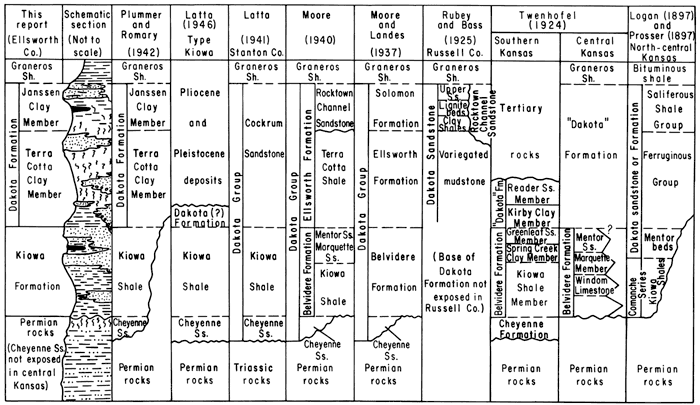
Nomenclature, definition, age, and correlation--Figure 5 is incorporated in this report to emphasize the complexity of nomenclature applied to rocks referred to here as the Kiowa Formation. Although the nomenclatural history of the Kiowa Formation is complex, excellent summaries are given by Bullard (1928, p. 40-47), Waite (1942, p. 135-137), and Latta (1946, p. 221-223). Considerable attention is given in this report to discussion of nomenclature of both the Kiowa and Dakota Formations, inasmuch as many of the stratigraphic problems associated with these rock units actually originated as problems in nomenclature and arose, in part, from study and differing interpretation of the rocks in this area by several authors.
Figure 5--Generalized section of Kiowa and Dakota formations in Ellsworth County and some of the variations in nomenclature and interpretation of stratigraphic relationships in Kansas. The Cheyenne Sandstone, which underlies the Kiowa Formation in its type area in southern Kansas, is not exposed in Ellsworth County but may have equivalents in the subsurface of western Ellsworth County. A larger version of this figure is available.
Recognition of beds of Cretaceous age at and near the type area of the Kiowa Formation in Kiowa County, Kans., is attributed to Mudge (1878, p. 47, 55). St. John (1883, p. 571) recognized the occurrence of rocks that contained marine fossils of Cretaceous age near the base of the so-called Dakota group of Meek and Hayden (1861) not only near Brookville, a few miles east of the Ellsworth County line in north-central Kansas, but also in Kiowa County in southern Kansas. St. John noted (p. 588) that the fossil assemblage was in many ways similar to that contained in the Cretaceous of the north Texas coastal plain.
Cragin (1894, p. 49) first used the name "Kiowa shales" to designate ". . . the inferiorly dark-colored and superiorly light-colored shales that crop out in several of the counties of southwestern Kansas, resting upon the Cheyenne sandstone in their eastern, and upon the 'red-beds' in their middle and western exposures, and being overlaid by brown sandstones of middle Cretaceous age, or Tertiary or Pleistocene deposits, according to locality . . ." in southwestern Kansas. With publication of the study by Prosser (1897) of the so-called Comanche series of Kansas, the name "Kiowa shales" seems to have come into fairly general use in approximately the same sense that the name "Kiowa" now is used in southwestern Kansas. However, the names "Belvidere beds" and "Medicine beds" have been applied to the same rocks in whole or in part from time to time (cf. Cragin, 1895b; Twenhofel, 1924, p. 20-34; Latta, 1946, p. 222, fig. 2). Cragin (1889, p. 37) seems to have been the first to recognize that shale lithologically and paleontologically equivalent to the Kiowa of southwestern Kansas also was present in north-central Kansas.
Subsequently, Cragin (1895a) studied the sandstone beds of north-central Kansas that contain marine fossils and introduced the name "Mentor beds" for them. He then correlated the sandstone beds with the higher parts of the Kiowa of the type area, and noted (p. 162) the presence of so-called Mentor beds in southeastern Ellsworth County.
In this report, rocks formerly classed either as "Kiowa shales" or as "Mentor beds" are both referred to as the Kiowa Formation. Although the lithic term "shale" traditionally has been used with the geographic term "Kiowa," the name Kiowa Formation is used in this report in recognition of the lithologic heterogeneity of the unit. Mapping for this report, not only in Ellsworth County but elsewhere in central Kansas (Franks, 1966) as well as in Clark County in southwestern Kansas (Swineford, 1947), demonstrates that the Kiowa generally is not the relatively monotonous sequence of nearly black or dark-gray to medium-gray shale seen in the type area (cf. Latta, 1946, measured sections, p. 251-256). Rather, the Kiowa Formation shows considerable lateral and vertical lithologic change. In many areas it is composed largely of sandstone (fig. 6) that interfingers laterally into more typical shale. Abundant dark-colored carbonaceous shale, clay, and siltstone as well as light-colored siltstone also are present in the Kiowa, particularly in those areas where thick sandstone grades laterally or vertically into more argillaceous rocks (fig. 7).
Figure 6--Thick lenticular deposit of sandstone (middleground) is Kiowa Formation exposed on the east shore of Kanopolis Reservoir near common corners of secs. 8, 9, 16, and 17, T. 16 S., R. 6 W. Thinner beds of sandstone are exposed along the lake shore on point in left middleground. Note gentle upland surface supported by Kiowa sandstone in background. Photo by Grace Muilenburg.
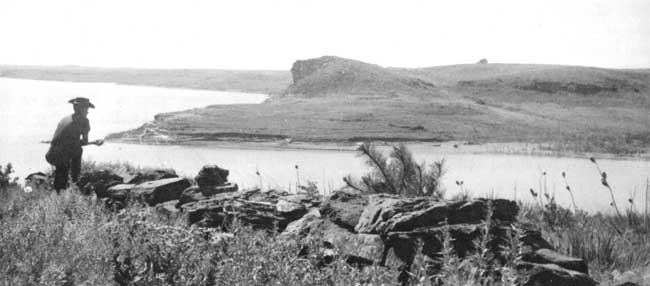
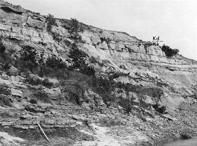
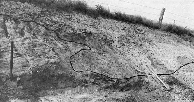
Figure 7--Exposure of Kiowa shale-Dakota Formation contact in cutback on the Smoky Hill River near the cen. S2 sec. 33, T. 15 S., R. 7 W. Topmost Kiowa sandstone forms ledge about 7.5 feet thick and contains abundant ellipsoidal masses of calcite cement in its upper parts. The sandstone is overlain almost directly by red-mottled Dakota siltstone (measured section 4). Within half a mile south (to right in photograph), the entire Kiowa section is replaced by sandstone.
The paleontologic work done by Twenhofel (1924) leaves no doubt that the Kiowa Formation of north-central Kansas correlates paleontologically with the Kiowa of the type area in southern Kansas, and that it also can be correlated with the Lower Cretaceous Comanche Series of the Texas coastal plain. Studies of foraminifera found by Loeblich and Tappan (1950) in shale in the type area in Kiowa County indicate that the Kiowa is correlative with the Kiamichi Formation of the Fredericksburg Group of northern Texas.
Work by Twenhofel (1924), Plummer and Romary (1942), and Merriam (1957), as well as by some of their predecessors, has established that the Kiowa of north-central Kansas not only is correlative in time with the Kiowa of southwestern Kansas but also constitutes a lithologic and lithogenetic extension of the rocks in southern and southwestern Kansas.
Lithology--The Kiowa Formation in Ellsworth County is a heterogeneous unit of shale and other argillaceous rocks, siltstone, and sandstone. The shale is medium to dark gray but characteristically weathers olive gray to olive brown. Most Kiowa shale is thinly laminated and plastic. In many places imprints of small pelecypods as much as 1 inch in the long dimension can be found by careful splitting of the shale along its lamination. R. W. Scott (oral commun., 1966) reports finding sorted assemblages of fish scales, teeth, and bone fragments associated with glauconite pellets along the bedding surfaces of Kiowa shale in Ellsworth County. The winnowed fish remains and glauconite pellets commonly are associated with imprints of pelecypods.
Plummer and Romary (1942) have noted that the red fired colors of illitic Kiowa shale generally serve to distinguish it from the more kaolinitic rocks in the overlying Dakota Formation.
Thinly laminated Kiowa shale generally contains numerous so-called clay-ironstone concretions. The concretions are composed mainly of very fine grained siderite, but contain some clay. They occur in thin discontinuous zones parallel to the lamination of the enclosing shale, have a discoidal form, and are as much as 0.3 foot thick and 4 feet in diameter. On weathering, the concretions break into angular fragments composed largely of hydrated iron oxides and are a useful criterion for recognition of the Kiowa Formation in grass-covered areas.
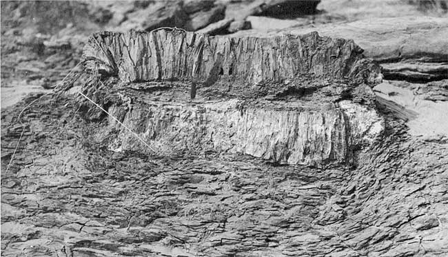
Calcareous cone-in-cone structure forms ellipsoidal concretions (fig. 8) and lenticular beds in the Kiowa Formation in many parts of Ellsworth County. Concretions showing cone-in-cone structure are as much as 1 foot thick and generally less than 6 feet long, whereas the lenticular beds of cone-in-cone are as much as 0.5 foot thick and 30 feet long. Concretions have the apices of the cones oriented toward a central shaly parting (fig. 8). The apices of cones in the lenticular beds of cone-in-cone may point either up or down.
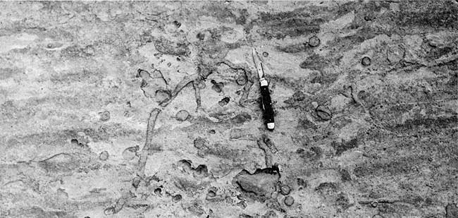
Figure 8--Concretion of calcareous cone-in-cone in Kiowa shale near the cen. S2 sec. 33, T. 15 S., R. 7 W. Pocket knife (handle about 3.5 inches long) is stuck in argillaceous core of concretion. Note contortion of shaly lamination about the concretion.
Twenhofel and Tester (1926) noted the abundance of cone-in-cone in southeastern Ellsworth County and parts of adjoining counties, and apparently suggested (p. 559) that the cone-in-cone formed a continuous layer that might be useful for correlation. Although zones of cone-in-cone are common in the lower parts of the Kiowa Formation in southeastern Ellsworth County, they occur at various stratigraphic positions within the Kiowa. Franks (1966) cites evidence that cone-in-cone in the Kiowa formed during early diagenesis when the enclosing sediments were still plastic and unlithified.
Commonly, sequences of brown or nearly black carbonaceous clay, siltstone, and shale are found near the top of the Kiowa Formation where they underlie and grade both laterally and vertically into what might be described as a cap sandstone (fig. 7). However, they are found in lower parts of the Kiowa Formation as well as along the bluffs and steep slopes in secs. 3 and 8, T. 17 S., R. 6 W. The fossil amber (jelinite) found in the NW SW sec. 18, T. 17 S., R. 6 W. (Buddhue, 1939a, 1939b), probably came from such a sequence in the lower parts of the Kiowa Formation.
Weathered slopes of argillaceous rocks belonging to the Kiowa Formation commonly are littered with abundant euhedral crystals of gypsum measuring as much as 2 inches in long dimension. In places abundant radial aggregates (sunbursts) of gypsum may be found on weathered exposures. The recrystallized gypsum is a secondary product derived from the weathering of disseminated iron sulfide, mainly marcasite, in the shale.
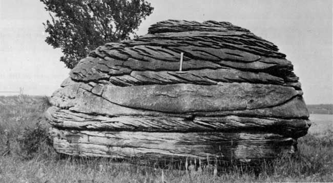
Sandstone is a major component of the Kiowa Formation in many places in Ellsworth County (fig. 6). Abundant sandstone is found in the northern half of T. 16 S., R. 6 W., and in parts of adjoining townships, such as in the vicinity of Mushroom Rocks (fig. 9). One prominent bluff in sec. 31, T. 15 S., R. 6 W., with petroglyphs near its base is composed entirely of sandstone and is nearly 60 feet high. Other prominent lenticular deposits of sandstone in the Kiowa Formation are found in the dissected uplands bordering the south and west shores of Kanopolis Reservoir in T. 16 S., R. 7 W., and T. 17 S., R. 6 W., and near the intersection of Kansas Highways 4 and 141 in T. 17 S., R. 6 W.
Figure 9--Cross-stratified calcite-cemented sandstone concretion in the SE SW sec. 19, T. 15 S., R. 6 W., at Mushroom Rocks State Park. Cross-stratification dip bearings are mainly southeastward.
Thick lenticular accumulations of sandstone in the Kiowa Formation commonly are found in the upper parts of the unit, but the sandstone exposed near the intersection of Kansas Highways 4 and 141 in T. 17 S., R. 6 W., extends from near the top of the Permian rocks to the base of the Dakota Formation and is nearly 100 feet thick. The thick lenses of sandstone generally support rugged topography, but in many places they underlie a gentle upland topographic surface that is interrupted only by low rounded hills or steep outliers of the overlying Dakota Formation (fig. 6).
The sandstone generally is very light gray to pale grayish orange, but in places hematitic stain and cement color it reddish brown.
The sandstone shows a wide variety of cross-stratification that is mostly medium and large scale (McKee and Weir, 1953) and includes wedge-planar, tabular-planar, and trough-shaped sets of high-angle cross-strata (fig. 9). Only locally is simple cross-stratification (McKee and Weir, 1953, p. 385-387) obvious. Even, horizontal lamination and bedding are relatively scarce in thick accumulations of Kiowa sandstone.
Contacts between the thick lenticular deposits of sandstone and underlying Kiowa shale are both gradational and disconformable, even in different parts of the same sandstone body. Where the contacts are gradational, grain size of the sandstone decreases downward as interbeds and laminae of shale become more abundant. The gradational sequences are mostly less than 10 feet thick. Where scour and fill contacts with Kiowa shale occur, fragments and pellets of reworked shale are common in the basal parts of the sandstone and locally are abundant enough to form shale and pebble conglomerates.
Bedding in the thin sandstone beds includes even horizontal lamination, micro-cross-stratification, and several kinds of ripple lamination. Linguloid ripple marks, symmetrical transverse ripple marks, asymmetric transverse ripple marks (fig. 10), and interference ripple marks (fig. 11) are common features on bedding surfaces. Small- and medium-scale tabular, wedge-planar, and trough cross-stratification also is seen. Tracks and trails of various burrowing or crawling organisms are common and Arenicolites burrows are characteristic (fig. 11). The sandstone may also contain molds and casts of pelecypods or Turritella.
Figure 10--Sample of calcite-cemented Kiowa sandstone exhibiting asymmetric transverse ripple marks. Wavelength ranges from about 2.5 to 3 inches. Sample is from topmost part of Kiowa Formation near the cen. sec. 24, T. 16 S., R. 8 W.
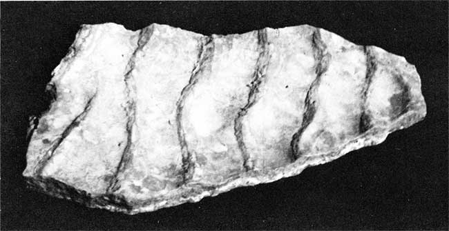
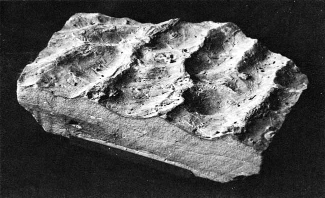
Figure 11--Sample of Kiowa sandstone from the cen. W2 sec. 7, T. 16 S., R. 11 W., on the east shore of Kanopolis Reservoir. Note interference ripple marks and characteristic pairing of wartlike projections of sand fillings of U-shaped burrows attributed to Arenicolites.
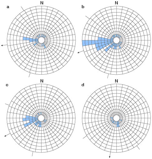
Measurements of cross-stratification dip bearings of Kiowa sandstone were made at 11 localities in Ellsworth County (Franks, 1966). Vector resultants (vector averages or means) calculated for each of the 11 localities are plotted in a circular histogram (fig. 12). Although the grand vector resultant trends S. 10° W., there is considerable dispersion of individual vector resultants and a prominent mode trends about S. 10° E.
Figure 12--Circular histograms of vector resultants of cross-stratification calculated for localities in Ellsworth County. Each block represents one vector resultant or locality; arrow indicates direction of grand vector resultant; arc delimited by either side of arrow is one standard deviation. (a) Janssen Clay Member, Dakota Formation, 21 localities; grand vector resultant is S. 83° W.; consistency ratio, 0.534; standard deviation, 67°. (b) Terra Cotta Clay and Janssen Clay Members, Dakota Formation, 52 localities; grand vector resultant is S. 71° W.; consistency ratio, 0.636; standard deviation, 58°. (c) Terra Cotta Clay Member, Dakota Formation, 31 localities; grand vector resultant is S. 64° W.; consistency ratio, 0.718; standard deviation, 51°. (d) Kiowa Formation, 11 localities; grand vector resultant is S.10° W.; consistency ratio, 0.730; standard deviation, 47°. Note the multimodal character of the distributions of vector resultants in the Dakota Formation and the prominent mode centered about S. 10° E. in the Kiowa Formation.
Thickness--The thickness of the Kiowa Formation ranges from 110 to 150 feet in Ellsworth County as determined by well logs and altitudes of the contacts. Inasmuch as the Permian-Cretaceous contact in north-central Kansas is an uneven surface, considerable local variation in thickness of the overlying Kiowa Formation may be expected. Moreover, the altitude of the Kiowa-Dakota contact commonly is highest where thick accumulations of sandstone are in the Kiowa Formation. Thus, the Kiowa Formation may be thickest where sandstone is most abundant and perhaps where the overlying Dakota is thinnest.
Environment of deposition of the Kiowa Formation--The Kiowa Formation was deposited in a transgressing sea that was connected with the Early Cretaceous seas in the coastal plain region of Texas and that formed part of a seaway that extended northward across the interior regions of the United States almost to the Canadian border (Reeside, 1957, p. 513-518). Measurements of directions of dip of cross-stratification in the overlying Dakota Formation in Ellsworth County (fig. 12), Ottawa County (Franks and others, 1959), and elsewhere in central Kansas (Franks, 1966) indicate that the regional direction of transport during deposition of the Dakota Formation was S. 50° to 70° W. There is little cause to suspect that the direction of inclination of the regional slope prevailing during deposition of the Kiowa Formation differed appreciably from that during deposition of the Dakota Formation, and it follows that the Early Cretaceous sea probably advanced from southwest to northeast across the eroded Permian rocks in central Kansas. Moreover, thinning and eventual disappearance of the Kiowa Formation near the Clay-Washington county line in north-central Kansas (Plummer and Romary, 1942, p. 322; Jewett, 1964) indicates that Kiowa sediments deposited in Ellsworth County may have accumulated near the margins of the sea.
Much of the shale was deposited in relatively quiet water where the bottom was only occasionally disturbed by currents and waves, but where conditions were not completely inhospitable to the maintenance of benthonic life. Neritic currents and wave action locally built deposits of interlaminated shale and sand or silt that grade upward into sandstone containing appreciable interstitial clay and commonly showing signs of an abundant bottom life. Oyster beds locally formed in estuarine bays or other places where low salinity and current or wave activity favored growth. When currents or waves acted somewhat more strongly, the oyster beds were destroyed and were reworked to form conquinoid "shell-beds." Where the supply of sand was sufficiently great, currents and waves built barrier bars and beaches behind which and between which carbonaceous muds were deposited and locally lignitic materials accumulated.
The climate on the nearby land to the east and northeast was mild. The upward increase in the abundance of sandstone and associated carbonaceous deposits in the Kiowa Formation in Ellsworth County is taken as evidence of regressive sedimentation that heralded deposition of the overlying, largely nonmarine Dakota Formation.
Kiowa Formation-Dakota Formation Contact
The Kiowa and Dakota Formations in Kansas generally have been considered to be conformable as well as vertically and laterally gradational. Twenhofel (1920, 1924) and Tester (1931) visualized large-scale and intimate intertonguing of the two units. Latta (1946, p. 249) stated, "In the upper part of the Medicine Lodge Valley in the Belvidere area, the Kiowa shale grades with apparent conformity into beds of sandstone, shale, and clay which contain fossil plants and are lithologically similar to certain beds in the Dakota formation of central Kansas." Swineford (1947, p. 58) stated, "The Dakota formation . . . is conformable on and intertonguing with the Kiowa shale, although in the northernmost part of the area it overlaps directly on Permian rocks." In his study of Rice County, Kans., Fent (1950, p. 57) described his placement of the Kiowa-Dakota contact as follows: " . . . the contact between the predominantly marine beds of the Kiowa shale and the nonmarine beds of the Dakota formation is arbitrarily placed at the top of the uppermost zone known to contain abundant marine fossils." On the other hand, Mack (1962, p. 17) indicated that the Dakota Formation rests unconformably on the Kiowa in Ottawa County, Kans.
Plummer and Romary (1942, p. 332) placed the Kiowa-Dakota contact at the base of one or more beds of siltstone or fine-grained sandstone containing ellipsoidal masses of calcite cement ("quartzites"). Locally, light-colored argillaceous rocks beneath the sandstone beds were included in the Dakota Formation. However, more than one bed of fine-grained sandstone containing ellipsoidal concretions of sandstone cemented by calcite can be seen in the Kiowa Formation along the shores of Kanopolis Reservoir. Fent (1950, p. 57-59) also noted the abundance of calcite-cemented sandstone in the Kiowa Formation in Rice County. Swineford (1947) examined calcite-cemented sandstone of the Kiowa not only in Ellsworth County but elsewhere in central Kansas. Thus, fine-grained sandstone containing abundant concretionary masses of calcite cement ("quartzites") may be more characteristic of the Kiowa Formation than of the Dakota Formation.
The lithology most characteristic of the Dakota Formation in Ellsworth County and elsewhere in north-central Kansas is gray to greenish-gray clay or siltstone showing red to reddish-brown mottles and commonly containing numerous spherules of siderite or its limonitic and hematitic alteration products. Accordingly, the contact between the Kiowa and Dakota Formations in much of Ellsworth County was placed at the base of red-mottled Dakota clay or siltstone or at the base of gray clay or siltstone enclosing lenses of red-mottled argillaceous rocks.
Red-mottled Dakota clay and siltstone commonly rest directly on or occur within a few feet above sandstone that grades downward into typical gray Kiowa shale or into carbonaceous deposits in the upper part of the Kiowa Formation (fig. 13). Arenicolites burrows are common both in the sandstone and in the underlying gradational sequences of interlaminated sandstone, siltstone, and shale.
Figure 13--Scour channel in the topmost Kiowa sandstone filled with gray Dakota siltstone having red mottles in a road ditch at Mushroom Rocks State Park near the cen. south line SE sec. 19, T.15 S., R.6 W. Tongue of Kiowa sandstone projecting into basal Dakota sandstone may stem partly from undercutting and partly from penecontemporaneous slumping. Bench in left middleground and dark soil are relicts from an old, partly excavated road ditch.
A zone enriched in iron oxide commonly is found at the top of the "quartzite"-bearing sandstone or at the top of a thin shaly interval that grades laterally into such sandstone (see measured sections 4 and 5). This enriched zone was selected as the top of the Kiowa Formation in many parts of eastern Ellsworth County. For practical use, however, the top of the sandstone is a more convenient datum for mapping purposes inasmuch as it is exposed more prominently than the overlying argillaceous rocks.
Thick lenticular deposits of sandstone near the top of the Kiowa Formation generally are overlain almost directly by red-mottled Dakota siltstone or clay. In at least one locality (fig. 13), basal Dakota siltstone fills a scour channel in the upper surface of a thick deposit of sandstone assigned to the Kiowa Formation. For this reason, one may conclude that the Dakota Formation was deposited disconformably on the Kiowa and that the concentration of iron oxide commonly seen at the top of the Kiowa Formation indicates an ancient weathering profile developed prior to deposition of the overlying Dakota.
In the SE sec. 32, T. 16 S., R. 7 W., the Dakota Formation rests on thick deposits of fine-grained sandstone assigned to the Kiowa Formation and contains abundant fine-grained thin-bedded sandstone in its basal parts. Some of the sandstone also shows transverse ripple marks on its bedding surfaces as well as burrows and trails similar in aspect to trace fossils found in the Kiowa Formation (fig. 14). Placement of the contact in this area would be difficult except that the sandstone beds in the basal parts of the Dakota Formation are intercalated with characteristic red-mottled siltstone, and the burrows and trails are of a size and form not seen in the Kiowa Formation in Ellsworth County.
Figure 14--Thin-bedded sandstone near the base of the Dakota Formation near the cen. W2 SE sec. 32, T. 16 S., R. 7 W. Although the symmetric transverse ripple marks are similar to those found in Kiowa sandstone, the burrows and trails have a form and large size not noted in the Kiowa Formation.
Dakota Formation
Original definition--The type area of the Dakota Formation is in northeastern Nebraska where it was defined as the Dakota group by Meek and Hayden (1861). They described it (p. 419) as "yellowish, reddish and occasionally white sandstone, with, in local areas, alternations of various colored clays and beds and seams of impure lignite . . ." and said it was found in the ". . . hills back of the town of Dakota [and was] also extensively developed in the surrounding country in Dakota County below the mouth of Big Sioux River, and thence southward into Northeastern Kansas and beyond." [Author's Note: "Northeastern Kansas" refers to the time when the Kansas Territory encompassed the eastern half of what is now Colorado. The area would be described as north-central and central Kansas today.]
History of nomenclature--Since its inception, the name "Dakota" has been used in different ways in different places. Variation in usage in Kansas alone has been manifold (fig. 5).
The classification used in this report ranks the Dakota as a formation and does not include the Cheyenne Sandstone and the Kiowa Formation as parts of a so-called Dakota Group (cf. Merriam, 1957, 1963). Ranking of the Dakota as a formation has been official usage of the State Geological Survey of Kansas since 1942. Although age considerations entered into acceptance of the Dakota as a formation in 1942 (Waite, 1942, p. 137), application of the name Dakota Formation originated directly from the work of Plummer and Romary (1942). Their classification was lithologic and was not founded on age considerations. However, they did recognize (p. 326) that the underlying Kiowa Formation thinned northward along the outcrop and did not extend into Nebraska. Moreover, the Cheyenne Sandstone is restricted essentially to its type area on the outcrop in southern Kansas, although subsurface extensions of the Cheyenne probably reach into north-central Kansas. Hence, rocks classed as Dakota Formation in Kansas and as Dakota Group in Nebraska (Condra and Reed, 1959) are lithogenetic and rock-stratigraphic extensions one of the other.
Plummer and Romary (1942) subdivided the Dakota Formation into two members--the Janssen Clay Member above and Terra Cotta Clay Member below. Both members have their type localities in Ellsworth County.
Lithology--The Dakota Formation in Ellsworth County (and elsewhere in north-central Kansas) comprises a thick heterogeneous sequence of clay, siltstone, and sandstone. Particularly near its top and locally near its base, the Dakota contains both shaly and lignitic beds or lenses. If one lithology were selected as being typical of the Dakota Formation, however, it would be kaolinitic light-gray to light-greenish-gray siltstone or clay dappled with abundant red to reddish-brown mottles.
The argillaceous character of the Dakota Formation in Kansas and northward into Nebraska and Iowa has been emphasized repeatedly in the literature. It is the dominantly kaolinitic and argillaceous character of the Dakota Formation that accounts for the important ceramic industry, which supports brick plants not only in central and north-central Kansas, but across Nebraska and in the vicinity of Sioux City, Iowa, as well. Yet, the concept that the Dakota Formation is basically sandstone persists, owing largely to poor exposure of the argillaceous rocks.
Clay and siltstone are estimated to comprise as much as 70 percent of the thickness of the Dakota Formation in many areas. Only locally does the aggregate thickness of sandstone exceed 40 percent of the thickness of the Dakota Formation. However, owing in large part to case hardening by iron oxide (Rubey and Bass, 1925, p. 57; Swineford, 1947, p. 71), the sandstone is resistant to erosion and stands out as capping layers on hills and benches. This indurated sandstone mainly accounts for the relatively rugged and scenic topography in the area of outcrop of the Dakota.
The argillaceous rocks of the Dakota Formation range from massive red-mottled siltstone and clay to highly carbonaceous gray to dark-gray siltstone and clay, either shaly or massive. They also may contain thin seams of white to very light gray thin-laminated nearly pure kaolinite. The siltstone and clay generally show little or no sign of lamination and commonly have conchoidal or blocky fracture. Much of the clay parts along irregularly disposed slickensided surfaces. Even thin-laminated clay and siltstone in the Dakota Formation commonly show little or no fissility, but fissile material is found near the top and bottom of the formation, particularly where the argillaceous rocks contain abundant carbonaceous matter.
Spherulitic siderite in the form of pellets as much as 2 mm in diameter is a common component of Dakota siltstone and clay. In most surface samples, however, the siderite is partly or completely weathered to goethite or other iron oxides. Pyrite and marcasite are common in carbonaceous and lignitic gray siltstone and clay. Veinlets and aggregates of gypsum also are found in weathered samples of siltstone and clay.
Beds of clay and siltstone in the Dakota Formation are mainly lenticular. They pinch and swell, grade laterally into beds of somewhat different color or lithology, and enclose lenses of other lithology. However, in some roadcuts and in some clay pits, individual beds can be traced for distances up to 50 yards without appreciable change in thickness or character.
Cross-stratification is a prominent feature in most Dakota sandstone. Small- and medium-scale tabular- and wedge-planar high-angle cross-stratification is most common.
Most of the Dakota sandstone is friable and lightly stained by iron oxide. Commonly, however, abundant iron-oxide cement is present, almost to the exclusion of quartz grains, where sandstone beds cap hills and benches. Where abundant iron oxide has accumulated in sandstone, bedding may be completely masked. The distribution of iron-oxide cement commonly is controlled by cross-stratification; the iron oxide forms bands that follow the cross-strata or pipe-like structures whose strike parallels the strike of cross-stratification. Elsewhere, iron oxide forms large tubular diffusion structures that follow the direction of dip of crossstrata.
In contrast to the abundance of calcite-cemented or dolomitic calcite-cemented sandstone in the Kiowa Formation in Ellsworth County, calcite or dolomite cement is scarce in sandstone of the Dakota Formation.
Sandstone lenses in the Dakota Formation show scour-fill contacts with underlying argillaceous rock. The sandstone at the top of measured section 4 is on the flanks of a scour-fill channel, the base of which is nearly 30 feet lower in altitude less than a quarter of a mile south of the described exposure and 15 or 20 feet lower than that 200 feet to the southeast. Similarly, the sandstone shown on figure 22, although it exhibits a nearly planar base in the photograph, has an obvious scour-fill relationship with the underlying contorted siltstone, clay, and sandstone. Generally, the size and shape of individual sandstone lenses are difficult to determine, but in places the lenses are elongate in the general direction of dip of contained cross-stratification. Laterally, sandstone lenses may either grade into or pinch out in sequences of siltstone and clay. Results of measurements of cross-stratification at 52 localities of the Dakota Formation are summarized on figure 12. The dominance of vector resultants to the west and southwest indicates that transport of most Dakota sandstone was from northeast or east to the southwest or west. An average direction of S. 71° W. was calculated.
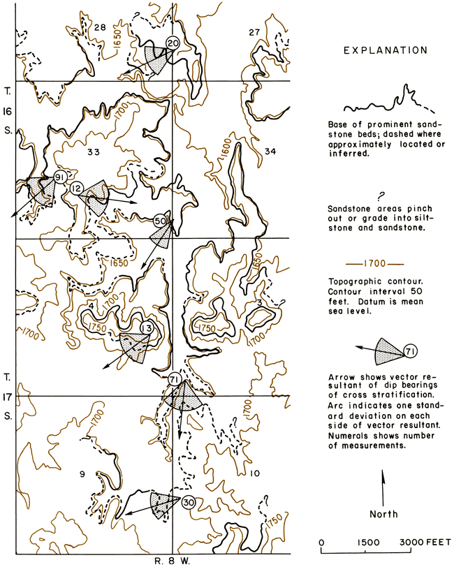
Sandstone in the Dakota Formation is erratically distributed and occurs as lenses of variable size, but the extent to which individual lenses are interconnected is problematic. Attempts to define such things as "first," "second," and "third sandstones" are unrealistic. Figure 15 is a detailed map for parts of Tps. 16 and 17 S., R. 8 W., south of Ellsworth. Several prominent lenses of sandstone are exposed in the area and their bases have been mapped on aerial photographs. Cross-stratification measurements were made at several localities. As a result, the map illustrates both the local variability of cross-stratification and the lenticular nature of Dakota sandstone. The authors estimate that as many as five or six lenses of sandstone are present in the 7-square-mile area. Although little information is available concerning size and shape of sandstone lenses in the Dakota, figure 15 indicates that the dimensions of some of the lenses can be measured in miles.
Figure 15--Map showing lenticular nature of sandstone and local variability of cross-stratification trends in the Dakota Formation in parts of Ellsworth County.
Thus far in the discussion of the lithology of the Dakota Formation, emphasis purposely has been placed on the heterogeneity and lateral variability of the several rock types. However, the formation is not without some system. It is precisely that system that allowed definition of the Janssen Clay and Terra Cotta Clay Members by Plummer and Romary (1942). Gray and dark-gray beds of siltstone and clay, as well as beds of lignite, are confined mostly to the upper third of the Dakota Formation, whereas red-mottled siltstone and clay are found mainly in the lower two-thirds. However, the basal parts of the Terra Cotta Clay Member also contain gray and dark-gray lignitic beds where they are intercalated in varying degrees with beds of red-mottled siltstone and clay. Similarly, seams of porcelaneous kaolinite are found near the base and in the upper part of the formation. Within the whole sequence of the Dakota Formation, some similarities in zonation of lithologic types can be observed from place to place. These similarities enabled Plummer and Romary (1942) to devise a generalized sequence for the argillaceous rocks of the Dakota Formation. That sequence follows in modified form. Modification was made by the authors in consultation with Norman Plummer. The sequence, however, should not be taken as being everywhere applicable, but parts of it may be recognizable from place to place in the belt of Dakota outcrops. The generalized section summarizes briefly the nature of argillaceous rocks in the Dakota Formation. Sandstone, except for that near the top of the formation that locally contains molds and casts of marine and brackish-water pelecypods (Hattin, 1965b), generally has been omitted from the generalized section.
| Generalized section illustrating overall nature of Dakota Formation in Ellsworth County. Sandstone lenses and beds may comprise from 30 to 50 percent of the sequence. | Thickness, feet |
|
|---|---|---|
| Janssen Clay Member: | ||
| 17. | Siltstone or shale, pale-yellowish-brown to brownish-gray, generally laminated to thin-laminated; commonly contains concretionary "limonite," hematite, or siderite, and laminae of fine-grained sandstone. May be a transition zone between typical Dakota and typical Graneros Shale. Locally grades laterally to fine-grained sandstone containing molds and casts of brackish water or marine pelecypods near top | 0.1-5.0 |
| 16. | Siltstone, gray to light-gray, generally resistant; contains carbonized plant debris as well as nearly vertical tubes that resemble molds of reed stems or roots or worm borings. Commonly supports a bench and is a good datum for mapping purposes. Locally grades laterally to sandstone like that noted above | 0.5-4.0 |
| 15. | Clay, dark-gray to black, weathers gray to light brownish gray, carbonaceous and generally contains one or more lignite seams, laminated to indistinctly laminated; commonly contains intercalated siltstone laminae. Locally grades laterally to sandstone like that noted in unit 17 | 0.0-8.0 |
| 14. | Clay, medium-gray, plastic; commonly contains lenticular beds of siltstone; carbonaceous debris and leaf fossils common. May be laminated or massive. Locally a white seam of porcelaneous kaolin, as much as 0.2 foot thick, occurs near top of unit | 15.0-30.0 |
| 13. | Clay, dark-gray with red mottles, plastic; may contain irregular siltstone lenses or laminae | 0.0-10.0 |
| 12. | Clay or siltstone, gray with abundant yellowish-orange stain especially on or near fracture surfaces, generally plastic, massive, conchoidal fracture; commonly contains one or more zones of siderite spherules | 15.0-30.0 |
| Typical thickness of Janssen Clay Member | 50-100 | |
| Terra Cotta Clay Member: | ||
| 11. | Siltstone, medium- to light-gray; contains abundant spherulitic siderite; generally weathers to form resistant ledge encrusted with iron oxides | 0.1-4.0 |
| 10. | Clay or siltstone, gray with or without red mottles and yellow stain, massive | 0.0-10.0 |
| 9. | Siltstone, gray to yellowish-gray, laminated to thin-bedded; contains carbonaceous debris. Locally has ellipsoidal concretionary masses of calcite cement | 0.0-10.0 |
| 8. | Clay, gray, massive; commonly contains fossil leaves and carbonaceous debris | 1.0-5.0 |
| 7. | Clay, dark-gray, carbonaceous, massive; contains fossil leaves | 0.1-3.0 |
| 6. | Clay or siltstone, light-gray to very pale greenish gray with abundant red mottles, massive, conchoidal fracture. Generally shows oblique jointing and contains several relatively persistent zones of spherulitic siderite at least partly altered to "limonite" or hematite. Generally contains thin beds of sandstone or silt- stone locally cemented by concretionary masses of calcite cement. Contains local irregularly shaped lenses of gray clay without red mottling | 100.0-150.0 |
| 5. | Siltstone, light-gray with red mottles and yellow stain, commonly calcareous and argillaceous; contains abundant siderite spherules; weathers to form resistant ledge encrusted with iron oxide | 0.5-3.0 |
| 4. | Clay or siltstone, light-gray with red mottles; commonly contains spherulitic siderite | 1.0-5.0 |
| 3. | Porcelaneous kaolin bed or seam, nonplastic, hard. Commonly appears as band of white fragments on weathered slopes | 0.0-1.0 |
| 2. | Clay or siltstone, medium- to dark-gray, plastic to nonplastic, commonly laminated to thin-laminated; contains abundant carbonaceous debris and locally seams of lignite; generally contains nodular aggregates of pyrite and may contain seams of kaolin like unit 3 above as much as 0.1 foot thick. May also enclose lenses of light-gray clay or siltstone with abundant red mottles | 5.0-30.0 |
| 1. | Clay or siltstone, light-gray with red mottles, plastic, conchoidal fracture, no obvious bed- ding. May enclose lenses of gray siltstone or clay as in unit 2 above or grade laterally into similar siltstone or clay | 0.0-5.0 |
| Typical thickness of Terra Cotta Clay Member | 150-250 | |
| Typical thickness of Dakota Formation | 200-300 | |
Thickness--Thickness of the Dakota Formation in Ellsworth County is difficult to determine owing to lack of continuous exposures and to the general width of the outcrop belt. Determination of thickness also is complicated by structural features. Thicknesses estimated by subtraction of the altitude of the basal contact from the altitude of the upper contact probably are misleading but range from about 190 to 250 feet. Although the basis for selection of the Kiowa-Dakota contact probably was not the same, thicknesses of the Dakota Formation recorded in southwestern Russell County by Swineford and Williams (1945, p. 154-166) mostly ranged from 200 to 250 feet.
Environment and features of deposition--The Dakota Formation generally is thought to have been deposited under nonmarine conditions in a low-lying coastal or deltaic plain bordering the Cretaceous sea that extended from the Gulf Coast region into the Western Interior of the United States and probably had connections with a sea reaching southward into the Western Interior from Canada (Haun, 1963, p. 128). The largely marine character of subsurface equivalents of the Dakota Formation described in northwestern Kansas by Merriam and others (1959) shows that the Dakota Formation grades westward into marine sediments, as do the marine and brackish-water fossils found in the upper part of the Janssen Clay Member.
The generally nonmarine or terrestrial nature of Dakota sedimentation in Ellsworth County can be inferred from the general absence, particularly in the Terra Cotta Clay Member, of marine fossils. Local abundance of leaf fossils, as well as lignitic beds near the base and top of the formation, are further evidence of the terrestrial character of Dakota sedimentation. Nonmarine vertebrates have been found in the Dakota Formation. Eaton (1960) described a fossil herbivorous dinosaur (ankylosaur) from the Terra Cotta in Ottawa County, Kans. Barbour (1931) reported the discovery of parts of a trachodon in the Dakota of Burt County, Nebr.
The dominantly kaolinitic character of the Dakota Formation can be taken as evidence of terrestrial or nearshore sedimentation. According to Weaver (1958, p. 258-259), ". . . kaolinite is dominant mainly in fluviatile environments . . ." although it may occur in abundance in nearshore sediments.
The abundance of kaolinite in the Janssen Clay Member, where argillaceous rocks are in close association with rocks containing marine and brackish-water fossils, is not so readily explained by subaerial leaching and weathering as by a large quantity of kaolinite being contributed to and deposited in a saline or brackish-water environment by Cretaceous streams. The massive, unlaminated character of much Dakota clay and siltstone, particularly in the Terra Cotta Clay Member, is suggestive of sedimentation by flocculation (Meade, 1964). Volcanic activity may have led to deposition of volcanic ash that locally was reworked and altered to seams composed almost completely of porcelaneous kaolinite in basal sequences of Dakota siltstone and clay.
Sandstone in the Dakota Formation is inferred to have been deposited mainly by streams and rivers. This conclusion is based partly on scour-fill contacts seen at the base of the many sandstone deposits, evidence of contemporaneous reworking of siltstone and clay, and directional orientation of cross-strata dip bearings in sandstone (fig. 12). The coarseness of some sandstone in the lower parts of the Terra Cotta Clay Member may be indicative of relatively rapid, though limited, uplift of the source areas of the sediments.
The dispersion of vector resultants of cross-strata dip bearings in the Terra Cotta Clay Member is markedly less than the dispersion shown by vector resultants in the Janssen Clay Member (fig. 12). The increased dispersion of vector resultants in the Janssen, combined with the finer grain size of Janssen sandstone compared with sandstone in the Terra Cotta, suggests a decrease in stream gradient and a consequent increased tendency for streams to meander or otherwise change course. The abundance of lignitic material in the Janssen may also indicate the onset of swampy conditions associated with the decrease of stream gradients as well as proximity to the shifting strand line of the encroaching Late Cretaceous sea.
Imprints of oak, willow, walnut, sycamore, magnolia, laurel, and sassafras leaves, among others, indicate that the climate was mild. The presence of fossils of cycads and figs may indicate that the climate was subtropical in some areas (Lesquereux, 1892, p. 256).
Terra Cotta Clay Member
The lower member of the Dakota Formation is characterized by red-mottled gray to greenish-gray clay and siltstone. Measured sections 4, 5, and 6 span the Kiowa-Dakota contact and describe the lower parts of the Terra Cotta Clay Member. Section 6 was measured near the old town of Terra Cotta. None of the sections, however, spans the full thickness of the member. The relative proportions of clay and siltstone to sandstone are significant and indicate the extent to which the Dakota Formation is mainly an argillaceous unit. However, coarse-grained and conglomeratic sandstone in the Dakota Formation is restricted principally to the Terra Cotta Clay Member.
In many places this interval, which has been designated informally as the "Andrews section" (Plummer and others, 1963, p. 4), contains relatively few lenses and beds of red-mottled siltstone and clay, but it often grades laterally into sequences composed largely of red-mottled material. The sequence has large reserves of relatively plastic buff-firing clay and siltstone suited for the manufacture of facing brick. Clay pits operated by the Kanopolis plant of Acme Brick Co. are located in this part of the Dakota Formation in secs. 25 and 28, T. 15 S., R. 7 W. The pit in sec. 34, T. 16 S., R. 8 W., probably is in this part of the Dakota.
The direction of transport inferred from measurements of dip bearings of cross-stratification for Terra Cotta sandstone is mainly southwestward (fig. 12c). The calculated grand vector resultant is S. 64° W., somewhat more southward than that calculated for the whole of the Dakota Formation. The likelihood is that channel deposits in the Terra Cotta Clay Member are elongate primarily in a southwestward direction in contrast to southward and southeastward elongation of sandstone deposits in the Kiowa Formation.
The contact between the Terra Cotta Clay Member and the overlying Janssen Clay Member does not constitute a stratigraphic datum. In contrast to the Terra Cotta, the Janssen is characterized by gray and dark-gray siltstone and clay, much of which is shaly, as well as beds and seams of lignite. The contact between the Terra Cotta and Janssen differs in stratigraphic position from place to place, and the beds or zones rich in iron oxide marking the separation are not everywhere present. However, it is not difficult to differentiate between the Terra Cotta Clay Member or the Janssen Clay Member, although it is difficult to determine the actual contact. The usefulness of the definition of the Terra Cotta Clay and Janssen Clay Members lies mainly in their gross lithologic differences and in the economic utility of the contained clays.
Thickness of the Terra Cotta Clay Member in Ellsworth County is difficult to determine, owing partly to lack of continuous exposure of the member; the lack of a definite stratigraphic datum separating the two members of the Dakota also makes thickness determinations difficult. However, the Terra Cotta comprises about two-thirds of the thickness of the Dakota Formation.
Janssen Clay Member
The Janssen Clay Member is composed mainly of gray and dark-gray siltstone and clay and contains lenticular beds of lignite and lignitic shale or clay. Carbonaceous siltstone is prominent in many areas and, locally, lenticular beds of red-mottled clay and siltstone are prominent (see measured section 7). Sandstone generally is less prominent in the Janssen than it is in the Terra Cotta Clay Member, although the so-called Rocktown channel sandstone (Rubey and Bass, 1925) seems to be an uncommonly thick sequence of lenticular deposits of sandstone mostly in the Janssen of northeastern Russell County. The argillaceous rocks of the Janssen Clay Member tend to form more persistent beds than the argillaceous rocks of the Terra Cotta Clay Member. Thin-lamination and shaly parting are much more common in the argillaceous rocks of the Janssen than in the Terra Cotta. Like the basal parts of the Terra Cotta, the Janssen locally contains thin seams of porcelaneous kaolinite. Spherulitic siderite is common in siltstone and clay of the Janssen Clay Member. Pyrite or marcasite is abundant in the more carbonaceous or lignitic parts of the member.
Schoewe (1952) reported the distribution and mining history of lignite in the Janssen Clay Member. Schoewe found that the lignite occurs in shaly seams or beds as much as 3 feet thick within the upper 25 feet of the Janssen Clay Member.
Sandstone in the Janssen Clay Member in Ellsworth County is generally fine grained and more poorly sorted than sandstone in the Terra Cotta. The proportions of clay matrix may be large, reaching values of 10 percent in some places. However, like most fine-grained sandstone in the Terra Cotta Clay Member, the sandstone is mostly clean and friable and only lightly stained by iron oxide.
Sandstone nearest the top of the Janssen shows even bedding and lamination. Locally, ripple lamination is apparent where shaly and carbonaceous films occur.
A prominent ledge-forming siltstone bed is found near the top of the Janssen Clay Member of the Dakota Formation in many parts of Ellsworth County (see measured section 7, fig. 23). Locally, the siltstone bed is as much as 3 feet thick. It is laminated to thin laminated and weathers pale grayish orange to very light gray or even white. Locally, it contains carbonaceous debris, argillaceous films, and mica flakes on bedding surfaces.
The overlying sequence also is capped by a concentration of limonitic iron oxide in many places and and is as much as 3 feet thick. The intercalated sequence of siltstone, sandstone, and shale supports a generally covered slope and is overlain by typical Graneros Shale. In many places a prominent bench is formed either on top of the resistant ledge-forming siltstone or on top of the overlying intercalated sequence (see fig. 23). The ledge-forming siltstone is not continuous. In places it grades laterally to interbedded shaly clay, lignite, and sandstone (see measured section 8). Elsewhere the siltstone is replaced by sandstone.
Brackish-water or marine pelecypods and foraminifers have been reported from sandstone in the upper parts of the Janssen Clay Member of the Dakota Formation in Ellsworth County and elsewhere in north-central Kansas (Hattin, 1965a, 1965b; Stanton, 1922; Tester, 1931), as well as from Janssen equivalents in eastern Nebraska (Meek, 1876; Stanton, 1922; Tester, 1931, 1952). The fossils near the top of the Dakota Formation are important for two reasons: (1) their bearing on the environment of deposition of the Dakota Formation, and (2) their bearing on the correlation and interpretation of stratigraphic relationships of the Dakota Formation to other formations. The locality reported by Hattin (1965a, p. 77) is in western Ellsworth County in the NW sec. 6, T. 15 S., R. 10 W., near the location of measured section 8 where abundant lignite and shaly clay in the upper parts of the Dakota Formation appear to grade laterally within short distances into a sequence composed largely of sandstone.
As is true for the other parts of the Dakota Formation, thickness of the Janssen Clay Member is variable and difficult to determine. The Janssen Clay is thought to comprise about a third of the thickness of the Dakota Formation. Vertical and lateral gradation with the Terra Cotta Clay Member probably accounts for some differences in thickness. Plummer and Romary (1942, p. 336) reported that the Janssen Clay approaches its minimum thickness in the type area in Ellsworth County where it is about 50 feet thick.
Dakota Formation-Graneros Shale Contact
The fossils found in the topmost parts of the Dakota Formation (Hattin, 1965b) and the lateral gradation of the upper parts of Janssen into the lower parts of the Graneros Shale discussed in the work of Eicher (1965) show the transitional nature of Janssen and Graneros sedimentation. Yet, a relatively sharp separation of the two formations can be made in most areas, even though Hattin (1964, p. 206) reported that reference to marker beds higher in the section shows that the position of the contact is nonuniform and ". . . reflects intertonguing of adjacent parts of the two units."
Ledge-forming siltstone, containing molds of reeds(?), that is very near the top of the Janssen Clay Member of the Dakota Formation constitutes a convenient reference throughout most of Ellsworth County and elsewhere in north-central Kansas. Although the interval above the siltstone is somewhat variable from place to place (unit 10, measured section 7), generally only a few feet of such transitional sediments separate the siltstone from typically plastic montmorillonitic Graneros Shale. Together the siltstone and the overlying material often support a bench that precisely marks the base of the Graneros Shale. The top of the transitional interbedded sandstone, siltstone, and shale is indurated by iron oxide that may have been derived by oxidation of concretionary siderite.
Where ledge-forming siltstone has been replaced by sandstone, the top of the Dakota Formation can be placed at the top of the sandstone. Elsewhere, the ledge-forming siltstone may be missing and argillaceous rocks of the Janssen may be overlain directly by basal Graneros Shale. However, the kaolinitic content and consequent generally nonplastic aspect of the Janssen rocks together with the abundant carbonaceous material contained in them permit fairly clear demarcation from the overlying Graneros Shale.
Cretaceous System--Upper Cretaceous Series
Colorado Group
Graneros Shale
Definition--The name "Graneros" was proposed by Gilbert (1896) for his lower division of the Benton group in eastern Colorado. He described the Graneros (p. 564) as ". . . a laminated, argillaceous, or clayey shale with very little admixture of limy or sandy materials." He reported the unit to be from 200 to 210 feet thick and resting on the uppermost sandstone of the Dakota Group. The name is derived from a locality on Graneros Creek at lat 37° 57' N.; long 104° 47' E. (which places it approximately in T. 24 S., R. 66 W., Pueblo County, Colo.).
Logan (1899) concluded that the Bituminous shale, the name be gave the basal unit of his subdivision of the "Limestone group" of the Benton formation in 1897, was stratigraphically equivalent to the Graneros shale of Gilbert in Colorado. Gilbert (1896) in his original description included the lower two members of the Greenhorn Limestone in the Graneros. Moore (1920) includes only the bituminous shales in the Graneros and includes the Lincoln Limestone Member and the Hartland Shale Member in the Greenhorn Limestone. This usage of the Graneros has been followed in Kansas since that time.
Hattin (1965a) discussed the paleoecology and depositional environment of the Graneros in central Kansas.
Distribution and thickness--In Ellsworth County the outcrop of the Graneros trends northeastward to southwestward. The outcrop extends westward up the Smoky Hill River valley about halfway across Russell County. The Graneros is best exposed in a narrow belt along steep slopes of the valley walls, which are capped by the Greenhorn Limestone, and in cuts along the highways.
The Graneros thickens westward from the outcrop belt in central Kansas. Scott (1962) reported 210 feet of Graneros in central Colorado, and Bass (1926b) reported 61 feet of Graneros in Hamilton and Kearny Counties in western Kansas. In central Kansas the thickness ranges from about 23 feet in eastern Mitchell County to about 40 feet in Russell and Ellsworth counties. In Ellsworth County the thickness ranges from about 28 feet in the northwestern part of the area to about 40 feet in the southwestern part (see measured sections 9, 10). The thickness is commonly 35 to 40 feet.
Lithology--The dominant lithology of the Graneros is noncalcareous montmorillonitic shale that ranges from slightly silty to fine sandy. In general, the shale is moderately silty (Hattin, 1965a). Unweathered Graneros shale breaks into irregular rather-tough blocks that split easily along obscure laminae. Upon weathering, the shale breaks into innumerable small flakes that characterize almost all Graneros exposures. The shale is soft and plastic when thoroughly wet, but is brittle when dry. The dominant colors of the partially weathered shale are medium light gray, olive gray, medium gray, and brownish gray. The highly weathered shale is generally moderate or dark yellowish brown, dusky yellow, or dark yellowish orange.
Most shale units in the Graneros contain numerous layers or lenses of silt or fine and very fine sand. These layers or lenses range from thin laminae to thin beds. The thinnest lenses and laminae are generally the most fine grained.
Most of the shale units contain gypsum either in finely granular or almost powdery form or as isolated platy aggregates of selenite.
Although shale is the dominant lithology of the Graneros, other lithologies occur throughout the formation. Noncalcareous or calcareous lenses and laminae of sandstone or siltstone are conspicuous in many Graneros exposures. Although most sandstone occurs as laminae or very thin beds, numerous sandstone and siltstone bodies are sufficiently distinct to be described individually. In Ellsworth County the noncalcareous sandstone beds or lenses occur most commonly in the upper part of the Graneros. Calcareous sandstone is generally near the middle part of the formation (Hattin, 1965a).
Cementation of the sandstone is generally poor, and locally the rock is not cemented; however, well-cemented lenses are present. The cement where present in the noncalcareous lenses is usually limonite, but in some places it is gypsum. The dominant colors of the sandstones in the Graneros are light olive gray, yellowish gray, and medium gray. The weathered calcareous sandstone is commonly dark yellowish orange.
Limestone lenses or beds, consisting largely of shell fragments ranging in thickness from about 0.1 to 0.3 foot, occur in the upper few feet of the Graneros in Ellsworth County. Although the limestone is dominantly composed of fine to very fine shell fragments, most of the beds contain some coarse organic debris including whole Inoceramus and Ostrea shells (unit 8, measured section 9). The fresh rock is light olive gray to olive gray and weathers dark yellowish orange. Thin beds containing abundant fragments of bone and teeth occur throughout the Graneros. These beds are dissimilar in their lithology, except for their content of vertebrate fragments, and locally are cemented with gypsum.
Several layers of bentonite, the thickest of which occurs near the top of the formation, are present in the Graneros. The upper bentonite bed is as much as 1 foot thick and usually occurs about 3 to 5 feet below the top of the formation in Ellsworth County (unit 4, measured section 10). It can be traced over much of the Western Interior (Hattin, 1965a). This bed is commonly pale greenish gray or yellowish gray but exhibits a wide range of coloration. The other bentonites in the Graneros range from a few hundredths of a foot in thickness to about 0.3 foot, and have considerable variation in thickness in short distances. The dominant weathering color is yellowish orange.
Concretionary zones occur in the Graneros in Ellsworth County. Most of the concretions are of the calcareous septarian type. Concretions about 4 feet below the top of the formation occur near the cen. N. line NE SE NW sec. 6, T. 15 S., R. 10 W., in the west road ditch (measured section 9). Concretions are most commonly found in the upper part of the formation but do occur sparingly in the lower part.
Cursory examination of the Graneros would seem to indicate an apparent absence of fossils in the formation; closer examination shows that fossils are present throughout the formation. Fossils occur in many of the shales and sandstones most commonly as casts but occasionally as well-preserved shells. Some of the thin limestones are composed primarily of fossil fragments, and the beds containing bones and teeth locally contain more fossil material.
Environment of deposition--Stratigraphic, lithologic, and faunal evidence indicates that deposition of the Graneros began in shallow, turbid, nearshore marine water of less than normal salinity. Later deposition occurred in progressively deeper, less turbid, offshore water of normal salinity (Hattin, 1965a). Increasing salinity during deposition is indicated by the combined evidence of distribution of kaolinite, limestone beds, inarticulate brachiopods, and ammonites. Water depth probably ranged from less than 30 feet during deposition of the lower part of the formation to about 70 feet for the middle part, with a maximum not exceeding 100 feet for the upper part (Hattin, 1965a). Coquinoidal limestone and bone beds are a consequence of storms that stirred bottom sediments at greater depths than usual and concentrated coarse organic debris.
Deposition of Graneros material was influenced by the discharge of streams into the transgressing sea. These streams created deltaic deposits along the margin of the sea. Silty shale and thin sandstone beds in the lower part of the Graneros accumulated in a nearshore environment and may be largely the deposits of a deltaic fore-set slope.
Graneros Shale-Greenhorn Limestone Contact
At most exposures of the basal part of the Greenhorn Limestone in central Kansas, skeletal limestones consisting chiefly of fragments of Inoceramus shells occur. These limestone beds are commonly crossbedded and have a petroliferous odor when freshly broken. The abruptness of the contact between the mostly noncalcareous shale in the upper part of the Graneros and the limestones of the Greenhorn is suggestive of a stratigraphic hiatus, because the contact at most places separates rocks deposited in a deeper, quiet-water environment from rocks deposited in a more turbulent environment. The contact between the Graneros and the Greenhorn in Kansas is placed at the base of the lowest of the yellowish-gray to brownish-gray skeletal limestones having a petroliferous odor. The contact can generally be easily determined by the change from the darker colors of the Graneros to the lighter yellow colors of the Greenhorn. This placement generally coincides with the change from predominantly noncarbonate to carbonate rocks.
Greenhorn Limestone
Definition--The Greenhorn Limestone was named by Gilbert (1896) from exposures near Greenhorn Station, 14 miles south of Pueblo, Colo., and constitutes the middle unit in his division of the Benton group. The following is a summary of his description. This formation consists of limestone strata, 3 to 12 inches thick, separated by somewhat thicker shale beds. The limestone is pale bluish gray, fine grained, and compact. The shales are light gray, laminated, and contain more lime than do the formations above and below. A few bands of white clay occur in the shales. Several limestone beds contain abundant fossils, chiefly Inoceramus labiatus. This particular shell, though not absent in other formations, is abundant only in the Greenhorn beds and thus serves to mark the formation.
Correlation of the Greenhorn at the type locality in Colorado with similar beds in Kansas was made by Logan (1899). He regarded the upper four subdivisions (Lincoln marble, Flagstone beds, Inoceramus beds, and Fence-post beds) of his "Limestone group" of the Kansas Benton to be stratigraphically equivalent to the Greenhorn Limestone of Colorado.
Rubey and Bass (1925) again subdivided the Greenhorn into an upper unnamed member, the Jetmore chalk member, a lower unnamed member, and the Lincoln limestone member. These subdivisions were not proposed as "new labels" on Logan's units, but they have different boundaries. Bass (1926a) proposed names for the unnamed units, the upper becoming the Pfeifer shale member and the lower, the Hartland shale member.
The Greenhorn Limestone is not readily divisible into its members in the field. In Ellsworth County, except for the contact between the Pfeifer Shale Member and the Jetmore Chalk Member where the top of the "shell bed" is used, the contacts between the members of the Greenhorn are obscure. These contacts are gradational and may be arbitrarily placed within an interval several feet in thickness. The upper contact of the formation with the Carlile Shale, as it is defined, is sharp and can be easily seen in the field. The lower contact with the Graneros Shale is easily identified using a lithologic change from predominantly shale to limestone, a change from noncalcareous or only partly calcareous to very calcareous, and a petroliferous odor for the lowermost limestone.
Lincoln Limestone Member
The basal unit of the Greenhorn Limestone is the Lincoln Limestone Member.
Definition--Cragin (1896) in his proposal of the name "Russell formation" for the lower Benton of Kansas states that this new formation includes the "Lincoln marble." However, he does not comment further on the "marble." Logan (1897) designates the second unit from the base of the Benton as the Lincoln Marble, which he describes (p. 216) as consisting of ". . . from two to five layers of hard flinty limestone intercalated with shale." Invertebrate fossils, especially species of Inoceramus, are abundant. Logan (1899, p. 83) states that the term marble is applied because the stone will take a "moderate polish." Rubey and Bass (1925) substituted the term limestone in the unit name.
Lithology--The Lincoln is described by Rubey and Bass (1925, p. 47) as
. . . beds of chalk and chalky shale, with thin beds of hard dark gray crystalline slightly sandy fossiliferous limestone at its base and top and in some places near the middle. The limestones emit a strong odor of petroleum on fresh fracture. A few thin beds of yellow clay occur in the lower half. . . . The beds of crystalline limestone are commonly only 2 to 6 inches thick and . . . although dark gray on fresh surfaces these beds are greenish or brownish gray where somewhat weathered.
In the north-central part of the county where the Greenhorn Limestone is only about 65 feet thick, the rocks here considered to represent the Lincoln Limestone Member average less than 5 feet thick (see measured section 12). These rocks are composed of chalk, chalky shale, and crystalline limestone commonly found in the lower part of the Lincoln. In western and southwestern Ellsworth County where the Greenhorn is 80 to 85 feet thick, the Lincoln is about 20 feet thick. The contact with the overlying Hartland Shale Member of the Greenhorn Limestone is gradational and cannot be definitely placed.
Hartland Shale Member
The second unit above the base of the Greenhorn Limestone is the Hartland Shale Member.
Definition--The presence of a member between the Lincoln Limestone and the Jetmore Chalk Members was acknowledged by Rubey and Bass (1925) in their classification of the Greenhorn, but no formal name was proposed for it. Bass (1926b) named this unit the Hartland Shale Member, a name derived from exposures near Hartland, Kearny County, Kans.
Lithology--The original lithologic description of the Hartland Shale Member in Russell County by Rubey and Bass (1925, p. 47) is summarized below. The Hartland consists of about 35 feet of chalky shale containing a few thin beds of chalk and clay. A crude quantitative analysis of this shale revealed a 65 to 70 percent silt content with a few flakes of muscovite. The most prominent bed is a 5-inch-thick hard medium-gray fine-grained chalk, 14 to 15 feet above the base, which contains well-preserved Inoceramus and flat vertical marks resembling grass blades. Below this prominent bed is 1 or 2 feet of yellow or light-bluish-gray clay and some gray and green chalky shale, and then another 5-inch-thick chalk bed which is softer, lighter colored, and less fossiliferous than the prominent chalk. Overlying the prominent chalk is 2 or 3 feet of chalky shale, which in turn is overlain by thin beds of chalk containing pyritic nodules and a few beds of yellow clay.
In Ellsworth County the Hartland is commonly about 20 feet thick. The contacts with the Jetmore Chalk Member of the Greenhorn Limestone above and the Lincoln Limestone Member below are gradational (measured sections 11 and 12).
Jetmore Chalk Member
The second unit from the top of the Greenhorn Limestone is the Jetmore Chalk Member.
Definition--The Jetmore Chalk Member was named by Rubey and Bass (1925) for the interval from 20 to 40 feet below the top of the Greenhorn. They described the uppermost bed (p. 46) as ". . . a hard, thin-bedded to massive, very fossiliferous fine-grained chalky limestone . . . about a foot thick." They further stated that "the base of the Jetmore member is not sharply defined, for . . . it grades into the underlying chalky shale." The unit is named (p. 51) from ". . . prominent exposures south and east of Jetmore, along the south side of Buckner Creek, in Hodgeman County, Kansas."
Lithology--The Jetmore Member, as described by Rubey and Bass (1925, p. 46), consists of alternating layers of chalk and chalky shale. The chalk beds decrease in thickness downward from 6 inches to 1 inch, and the beds of chalky shale decrease from about 2 feet to 2 inches.
The Jetmore is about 20 feet thick in Ellsworth County. The lower contact with the Hartland Shale Member is gradational and generally cannot be definitely placed. The upper contact of the member is at the top of the chalk called the "Inoceramus limestone" or "shell bed" by petroleum geologists. A bed of chalky concretions occurs about 2 feet below the upper chalk bed.
Pfeifer Shale Member
The uppermost unit of the Greenhorn Limestone is the Pfeifer Shale Member.
Definition--In their subdivision of the Greenhorn in Russell County, Rubey and Bass (1925) have an unnamed upper member comprising the upper 20 feet of the formation. This member is described as a chalky shale containing three beds of 4- to 10-inch-thick chalk, the uppermost of which is the Fence-post limestone bed. Bass (1926a, p. 32) named this unit the Pfeifer Shale Member from exposures near the town of Pfeifer in Ellis County, Kans., and designated a type section in a road cut in the SE sec. 21, T. 15 S., R. 17 W.
Lithology--The lithologic sequence of the Pfeifer in Russell County according to Rubey and Bass (1925, p. 45) is as follows. The uppermost bed, known as the "fence-post limestone," is a rather hard, slightly sandy, fairly coarse but even-grained and massive chalk, commonly light-yellowish-gray with a rusty median line on weathered outcrop and 8 or 9 inches thick. Below the "fence-post limestone" bed is 8 or 9 feet of soft chalky slightly gritty shale containing several layers of thin concretions. Next below is a hard layer of iron-stained chalk, 5 inches thick, containing many Inoceramus shells. Underlying the hard chalk is 5 feet of chalky shale. The next lower part is described (p. 46) as ". . . a zone 2 1/2 feet thick of thin, highly fossiliferous concretionary chalk beds." The basal part is 4 feet of chalky shale.
In Ellsworth County the Pfeifer Shale Member ranges in thickness from 18 to 21 feet. The contact with the underlying Jetmore Chalk Member is placed at the top of the "shell bed," and with the overlying Carlile Shale, at the top of the Fence-post limestone bed.
Carlile Shale
Definition--Gilbert (1896), working in the Arkansas Valley of southeastern Colorado, named his upper division of the Benton group the Carlile. It is described (p. 565-566) as 175 to 200 feet thick and similar in lithology to the Graneros. The dominant color is medium gray with the middle third somewhat darker. This unit is finely laminated and argillaceous in the eastern part of the district, but westward the lamination becomes coarser or disappears, whereas the upper fourth becomes sandy. Locally, light-yellow sandstone occurs, especially near the top of the formation. The sandstone is friable with argillaceous material filling the pores between sand grains. Farther east, the sandstone often is replaced by a purple limestone, 2 or 3 feet thick, having abundant Prionocyclus wyomingensis, which usually are seen only in outline. Many calcareous concretions, ranging from a few inches to 4 or 5 feet in diameter and thick ovoid to spherical in form, occur from 20 to 50 feet below the top of the formation. The outer shell of the concretions has cone-in-cone structure with apices pointing toward the center of the concretion, whereas the inner part is fine textured and gray. The interior of the larger concretions is traversed by large cracks, partly or wholly filled by crystalline calcite. Gilbert (1896, p. 565) states, "From 50 to 75 feet above the base of the formation there is sometimes found, especially in the eastern part of the district, a thin, limy bed with fossils." In a footnote (p. 570), Gilbert named Carlile Spring and Carlile Station, 21 miles west of Pueblo, Colo., as the type locality. Essentially the same description of the Carlile is given by Gilbert (1897, p. 3) in discussing the geology of the Pueblo quadrangle.
Logan (1897) defined an upper shale group of the Benton in Kansas as consisting of the Ostrea shale below and the Blue Hill shale above. Logan (1899) concludes that his shale group is the stratigraphic equivalent of Gilbert's Carlile shale of Colorado.
As the Blue Hill Shale Member is not present in Ellsworth County, discussion of the Carlile is restricted to the lower member, the Fairport Chalk Member.
Fairport Chalk Member
The lower unit of the Carlile Shale is the Fairport Chalk Member.
Definition--Fairport was proposed by Rubey and Bass (1925, p. 40-45) as a proper stratigraphic name for the Ostrea shale of Logan. The type exposures are in the vicinity of Fairport, a small community in northeastern Russell County, Kans. The Fairport chalk member, as it was called by Rubey and Bass, comprises 85 feet of "chalky marl and thin chalk beds." Only about 15 feet of this unit is present in Ellsworth County. Like Logan, they placed the lower boundary at the top of the Fence-post limestone bed (measured section 11). The upper boundary is placed at the contact between noncalcareous and calcareous strata (determined by using dilute hydrochloric acid). They note the presence of yellow clays (bentonite) and several zones of ellipsoidal calcareous concretions. The beds are dark gray when freshly exposed, but weather to light tan. Rubey and Bass found the oyster Ostrea congesta in abundance and some specimens of the ammonite Prionotropis woolgari, the worm Serpula tenuicarinata, and a clam regarded as similar to but not identical with Inoceramus dimidius.
Lithology--Only the lower part of the Fairport is present in Ellsworth County, and exposures are relatively scarce. The lithology of the lower Fairport seems consistent and is comprised of soft laminated chalk containing several thin limestones and ovoid limestone nodules. Approximately the lowermost 5 feet of the Fairport is very similar in appearance and character to the upper part of the Greenhorn Limestone. Above this lower 5-foot zone the nodules become scarce and smaller, the limestone layers get thinner and occur less frequently, and the clay content of the sediments increases (measured section 11).
Stratigraphic relations--The Fairport is conformable with the Greenhorn; in fact, deposition apparently was uninterrupted. From the description by Rubey and Bass, (1925, p. 43) the Fairport-Blue Hill contact apparently is conformable also.
Environment of deposition--The lower Fairport apparently originated in a continuation of the environment in which the Greenhorn was deposited--shallow, clear, fairly warm marine waters. Such conditions would have been ideal for the clams and lime-fixing protozoans found in abundance as fossils. As deposition continued, the amount of fine noncarbonate particles accumulating increased (perhaps from windblown volcanic ash or dust and settling of suspended terrigenous mud), but not at a rate sufficient to deter growth of lime-fixing animals.
Tertiary System--Pliocene Series
Ogallala Formation
The name Ogallala Formation is applied to the sediments of Pliocene age in Kansas. A summary of the general aspect of the formation is given by Frye and others (1956, p. 8):
The Ogallala formation of northern Kansas is a heterogeneous complex of clastic deposits. The thickness of the formation ranges from more than 300 feet to less than 3 feet; the texture ranges from coarse gravel containing pebbles as much as 3 inches in long diameter to clay; and the sorting ranges from good to poor. Cementing material, not everywhere present, includes tough opal, disseminated white opal, and various amounts of calcium carbonate. Colors of the deposits are dark to pale green, pink, reddish brown, tan, buff, pastel grays, and ash gray. Lentils of volcanic ash, marl or marly limestone, and bentonite contrast with the predominate stream-laid clastics. Throughout this heterogeneous assortment of sediments there is virtually no distinctive bed that can be traced appreciable distances in the field.
The Ogallala has been divided into three members in Kansas. The lowermost member is the Valentine Member, which is overlain by the Ash Hollow Member. The upper member is the Kimball Member. The upper surface of the Kimball is marked by the widespread occurrence of a distinctive bed called the "algal limestone." The name "algal limestone" was introduced by Elias (1931, p. 138) in the belief that the structures in the limestone were the work of algae, but Swineford and others (1958) present evidence that the bed resulted from soil-forming processes.
In Ellsworth County only the uppermost bed, the "algal limestone," is present. About 40 localities were visited during this investigation where the so-called algal limestone crops out. These outcrops occur in small knobs or ridges occupying the highest topographic positions in the general area of the outcrop. The thickness ranges from a few inches to about 3.5 feet. The "algal limestone" deposits in Ellsworth County do not represent clastic deposits but rather are the remnants of a widespread soil formed in this area during late Pliocene and possibly into early Pleistocene time. The deposits occur only in divide areas and serve as marker horizons, which have been relatively stable since the close of the Pliocene Epoch. Figure 16 shows contours on top of the "algal limestone" in and adjacent to part of Ellsworth County. The contours indicate a general slope toward the east and also show topographic highs near the present drainage divides between the Saline and the Smoky Hill Rivers and between the Smoky Hill and Arkansas Rivers. There is some indication that a drainage channel existed in or near the Smoky Hill Valley and the abandoned Wilson valley. Any clastic material that may have been deposited in these valleys by late Pliocene streams is not recognized or has been removed by Pleistocene erosion.
Figure 16--Configuration of the top of the "algal limestone" in parts of Ellsworth, Lincoln, Russell, Barton, and Rice counties.
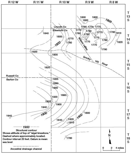
During late Pliocene time, the Smoky Hill River below Wilson valley flowed near its present location for a distance of about 30 miles to a point near Marquette in McPherson County where the river entered the McPherson channel, which is an abandoned buried channel extending southward and joining the ancestral Arkansas River just west of Wichita in Sedgwick County. The lowermost deposits in McPherson channel are Pliocene in age (Lane and Miller, 1965).
Quaternary System-Pleistocene Series
Pleistocene deposits in Kansas are of continental origin and are composed of silt, clay, sand, gravel, and small amounts of volcanic ash. The Pleistocene Epoch as defined by the State Geological Survey of Kansas was the last of the major divisions of geologic time and has been called the "ice age" owing to the presence of continental glaciers in North America and elsewhere. The Pleistocene Series in Kansas has been divided into the Nebraskan, Kansan, Illinoisan, and Wisconsinan glacial stages and the Aftonian, Yarmouthian, and Sangamonian interglacial stages. Events in each of the periods of continental glaciation followed a cyclic repetition. Each cycle consisted of a glacial and an interglacial interval or stage. The cycle in a marginal belt around a glaciated area was characterized by a period of down-cutting in the valleys and some local deposition of sediments, in turn followed by a period of deposition of coarse material, deposition of progressively finer material as the glacier retreated, and finally, during the interglacial stage, little or no deposition and the development of a soil profile over a large area where surface conditions were relatively stable.
During the Nebraskan and Kansan Stages continental glaciers entered northeastern Kansas. During the Illinoisan and Wisconsinan Stages the continental glaciers did not reach Kansas, but the climatic changes accompanying their approach had a direct effect on the Pleistocene deposits in Kansas.
Ellsworth County is about 100 miles from the nearest approach of any of the ice sheets and did not receive outwash material from the glaciated area. The principal effect in Ellsworth County during the glaciations, therefore, was climatic. Ellsworth County is drained by the Smoky Hill and Saline rivers, except for an area of about 80 square miles in the southwestern part of the county that is drained by the Arkansas River. The Smoky Hill and Saline rivers headed in western Kansas and have never had direct connection with drainage from the Rocky Mountains. The Arkansas River in central Kansas probably had no connection with Rocky Mountain drainage until late Kansan or early Illinoisan time, indicating that mountain glaciation during the Pleistocene had no direct effect on the Pleistocene deposits in Ellsworth County. The source of the material comprising the Pleistocene deposits in the county has been the Ogallala Formation in the western part of the state and the local bedrock.
The Smoky Hill River in Ellsworth County has been cutting its channel at or near its present course throughout the Pleistocene and possibly during late Pliocene time. During each succeeding glacial stage, the channel has been incised to a lower altitude. The Saline River has followed closely its present course from western Kansas to a point near the northwest corner of Ellsworth County throughout the Pleistocene. During early Pleistocene and probably late Pliocene time, the Saline River entered Ellsworth County near the northwest corner and flowed southeastward through the now abandoned Wilson valley into the Smoky Hill River at a point just west of Ellsworth.
Nebraskan and Aftonian Stages
Holdrege and Fullerton Formations
During the Nebraskan and Aftonian Stages, the Smoky Hill River did not head in western Kansas. The upper Smoky Hill drainage during this time was through Galatia channel to the ancestral Arkansas River (Bayne and Fent, 1963). That part of the Smoky Hill River below Galatia channel was tributary to drainage through Wilson valley and the Saline River, which drained through McPherson channel to the ancestral Arkansas River.
Deposits representing the Holdrege and Fullerton Formations of Nebraskan age are locally present along the edges of the valleys of the Smoky Hill River and Wilson valley. These deposits are discontinuous and have little surface expression. Generally the Holdrege and Fullerton underlie the dissected slope between the relatively flat surface of Kansan age deposits and the valley wall. Test holes and geologic sections (A-A', B-B', and D-D', pl. 2) indicate that these deposits rest on a bedrock bench and are in a terrace position relative to the younger Kansan deposits. The Holdrege and Fullerton Formations were not mapped, because they are poorly exposed. They are included in the area mapped as the Grand Island and Sappa Formations of Kansan age on the geologic map (pl. 1).
In Ellsworth County the Holdrege and Fullerton Formations are composed of silt with minor amounts of clay and generally some sand and gravel in the basal part of the deposit. Locally, some caliche is present in the upper part. These deposits may be as much as 40 feet thick but more commonly are about 15 or 20 feet thick.
Kansan and Yarmouthian Stages
Grand Island and Sappa Formations
During early Kansan time, the streams in Ellsworth County deepened their channels. The valleys were incised below the base of the Nebraskan deposits, and most of the Nebraskan deposits were removed (A-A' and D-D', pl. 2). Galatia channel, which had drained the upper Smoky Hill River into the ancestral Arkansas River, was abandoned, and the upper Smoky Hill drainage was integrated with drainage through the McPherson channel in McPherson, Harvey, and Sedgwick Counties. Figure 17 shows the drainage pattern in northern Kansas during the Kansan Stage of the Pleistocene.
Figure 17--Drainage patterns of streams in northern Kansas during the Kansan Stage. (1) Area drained through McPherson channel. (2) Area drained through the lower Smoky Hill River (Bayne and Fent, 1963).
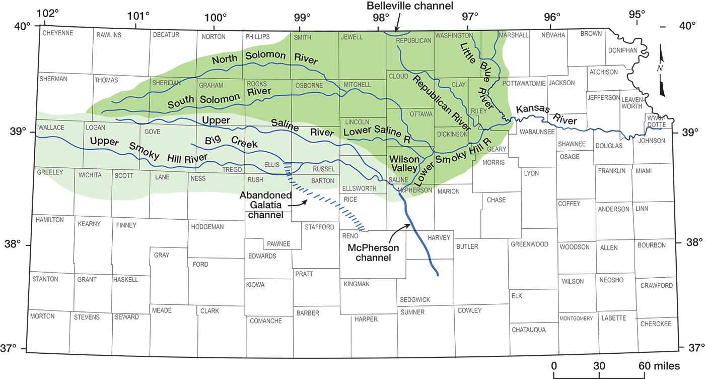
In late Kansan time, streams flowing across Ellsworth County became less competent and, as a result, finer sediments were deposited in the upper part of the valley fill. By the end of Kansan time, the Smoky Hill and Saline Rivers, which flowed through Wilson valley as well as most of the tributary streams, had filled their channels almost to the level of the Nebraskan deposits. The Grand Island and Sappa Formations deposited during the Kansan Stage are present throughout Wilson valley and crop out in an almost-continuous belt on both sides of the Smoky Hill River valley (pl. 1). The combined thickness of the Grand Island and Sappa Formations ranges from only a few feet to as much as 70 feet, but more commonly is less than 50 feet thick.
In the Smoky Hill Valley and Wilson valley, these deposits consist of clay, silt, sand, gravel, and some volcanic ash. The sand and gravel in the main channels is mostly arkosic, having been derived from Pliocene deposits in western Kansas. The deposits in tributary streams are derived from the local bedrock. In the lower part of these deposits, sand and gravel are the dominant materials, but silt and clay also are present, especially in the smaller streams. The upper part of the valley fill is composed principally of silt, although some clay, sand, and gravel are present.
In late Kansan time the Pearlette volcanic ash was deposited. This ash forms discontinuous beds in the Sappa Formation, is present in isolated deposits throughout the Midwestern states, and is an important stratigraphic marker. The Pearlette, along with an associated molluscan fauna, has been used to date and correlate the Kansan age deposits in the Smoky Hill River valley and Wilson valley (Frye and others, 1943). The Pearlette ash crops out in six localities in Ellsworth County. All these outcrops occur in tributary valleys rather than in main channels. In two of the localities, a sparse molluscan fauna associated with the ash is present but was not collected or studied. In Lincoln County about 1 mile north of the Ellsworth County line in Wilson valley, numerous ash deposits are present. A rich molluscan fauna (Wilson valley fauna) and scattered vertebrate fossils are associated with the ash in this area. In Russell County in the south valley wall of the Smoky Hill River about 1 mile west of Ellsworth County, Pearlette ash and a molluscan fauna (Tobin fauna) are present. Both the Lincoln County and the Russell County localities have been studied and reported by Frye and others (1943).
Deposits of Kansan age in tributaries to the Smoky Hill River are thin and are not generally traceable more than short distances. Silt and clay are the dominant materials comprising the deposits, although locally sand and gravel derived from the local bedrock are present in the basal part of the deposits. These deposits are not shown on the geologic map (pl. 1).
A triangular-shaped area in southern and southwestern Ellsworth County, the northern boundary of which nearly coincides with the drainage divide between the Smoky Hill and Arkansas Rivers, is underlain by Pleistocene deposits (pl. 1). The upper part of these deposits is nearly everywhere composed of silts of late Pleistocene age; however, several buried channels which drained the area during early Pleistocene time are present. Figure 18 shows the contours on the bedrock surface and the location of these buried channels. The deposits in these channels consist principally of silt and clay, but sand and gravel derived from the local bedrock is present in the lower part of the deposits. They may be as much as 60 feet thick, but are commonly less than 30 feet thick. These channel deposits are assigned a Kansan age and are considered to be part of the Grand Island and Sappa Formations.
Figure 18--Configuration of the bedrock surface and buried channels in southwestern Ellsworth County and northern Rice County.
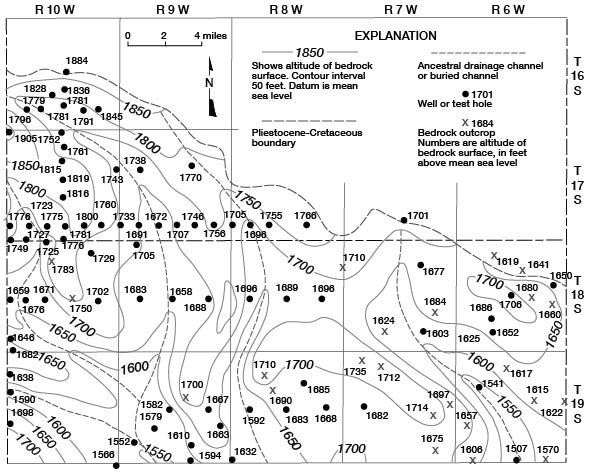
Fent (1950) considered the deposits in the extensions of the channels in Rice County to be of Kansan age, because water-worn pebbles of caliche are common throughout the deposits. He considered the caliche to have been derived from a soil caliche formed during the Aftonian interglacial stage. This caliche differs from the "algal limestone" caliche of late Pliocene age in that the distinct banding in the "algal limestone," which gives it the appearance of being algal in origin, is missing.
Illinoisan and Sangamonian Stages
Drainage in central Kansas at the beginning of the Illinoisan Stage was probably through the same channels as in the Kansan Stage; however, Wilson valley in Ellsworth County and McPherson channel east of Ellsworth County were largely filled with Kansan sediments, and the stream that flowed through these valleys in earliest Illinoisan time probably had a low gradient and was sluggish.
In late Yarmouthian time and early Illinoisan time, the channel of the Saline River below or east of Wilson valley and the channel of the Smoky Hill River below McPherson channel were deepened and extended westward in their headwater areas. In early Illinoisan time, either because of an increased rate of erosion or because the old low-gradient channels of Wilson valley and McPherson channel would not carry the increased load, drainage through these channels was captured and diverted through the lower Saline River and the lower Smoky Hill River, establishing the present drainage system in this part of Kansas (fig. 19). Other stream captures on smaller streams occurred at about this time as these streams adjusted to the changes in the main channels. Figure 20 illustrates a capture of the headwaters of Clear Creek, a tributary to the Smoky Hill River, by Elkhorn Creek, a tributary to the Saline River.
Figure 19--Upper Kansas River basin drainage during Illinoisan and Wisconsinan Stages and abandoned Pleistocene channels (Bayne and Fent, 1963).
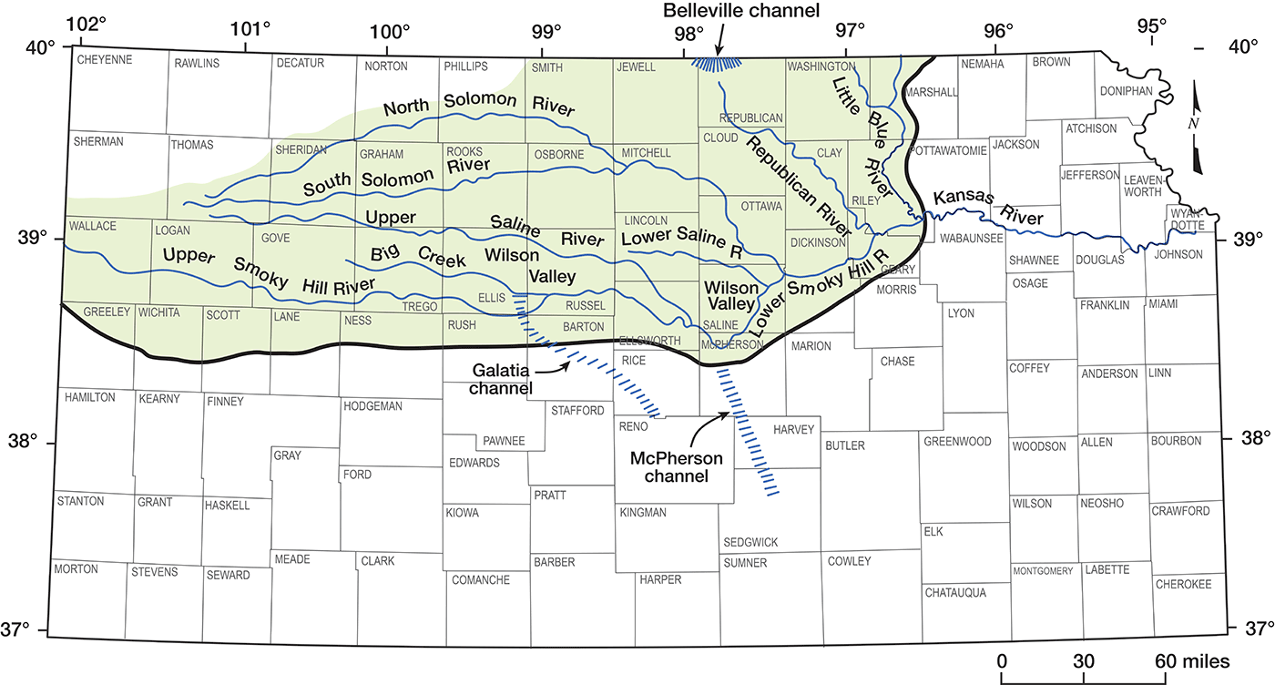
Figure 20--Map illustrating capture of headwaters of Clear Creek by Elkhorn Creek.
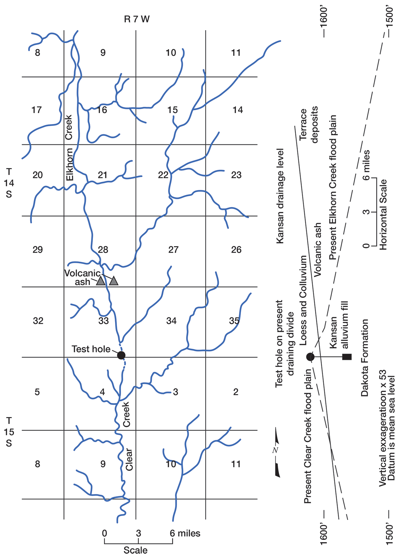
Crete Formation
Following the abandonment of Wilson valley and McPherson channel, the valley of the Smoky Hill River was deepened rapidly to a point well below the base of the Kansan deposits. This valley was filled in late Illinoisan time with alluvial deposits to a point 30 to 40 feet below the adjacent Kansan deposits (D-D', I-I', and J-J', pl. 2). These deposits are as much as 50 feet thick and comprise the Crete and Loveland Formations. The Crete Formation represents the coarse phase of the alluvial cycle of the Illinoisan Stage, and the Loveland Formation represents the phase of deposition when the finer sediments were deposited and may be either fluvial or eolian in origin.
Loveland Formation
During late Illinoisan time, loess of the Loveland Formation was deposited over much of Kansas. The thickest deposits of Loveland loess occur in northern and northwestern Kansas. In Ellsworth County the Loveland loess is probably no more than 10 feet thick and is not separated from the younger overlying Wisconsinan loess on the geologic map. In Wilson valley and in the buried channels in southwestern Ellsworth County, deposits resembling loess in drill samples (pl. 2), but which probably are largely colluvium or water-laid silts derived from the loess, are present. Locally, these deposits may attain a thickness of 20 feet. They do not crop out and are not shown on the geologic map.
Wisconsinan Stage
Fluvial Deposits
Since early Illinoisan time the drainage pattern in Ellsworth County has been essentially unchanged; however, the valleys have been deepened.
Early in the Wisconsinan Stage the stream valleys in Ellsworth County were deepened to a point well below the deepest Illinoisan incision (D-D', I-I', and J-J', pl. 2) and later filled with alluvial materials to a point 20 to 30 feet below the surface of the Illinoisan alluvial deposits. In other areas in Kansas, a second phase of cutting and filling occurred during late Wisconsinan time, but this twofold sequence of cutting and filling during the Wisconsinan was not recognized in Ellsworth County.
The Wisconsinan alluvial deposits in the stream valleys in Ellsworth County are similar in mode of occurrence and composition to those of the other stages of the Pleistocene inasmuch as they are composed of silt, clay, sand, and gravel; the coarse material generally occurs near the base of the deposit, and silt or sand generally comprises the upper part of the deposit. Wisconsinan fluvial deposits in the Smoky Hill Valley are generally better sorted and more permeable than the materials deposited in the earlier stages of the Pleistocene. Wisconsinan fluvial deposits in the Smoky Hill River valley are as much as 60 feet thick. In the tributary valleys, these deposits are commonly less than 30 feet thick.
Peoria Formation
During the Wisconsinan Stage loess was deposited in Kansas in two separate phases. The earlier Wisconsinan loess comprises the Peoria Formation, and the later loess comprises the Bignell Formation in the Kansas classification. The Peoria Formation is probably equivalent in age to the lower Wisconsinan fluvial deposits, and the Bignell Formation is probably equivalent to upper Wisconsinan fluvial deposits. The greatest thickness of Wisconsinan loess was deposited in northern Kansas. In northwestern Kansas the Peoria may exceed 50 feet in thickness, whereas the Bignell probably does not exceed 10 feet. In northeastern Kansas near the Missouri River both the Peoria and Bignell may exceed 50 feet in thickness. In Ellsworth County the Peoria is thin, having an observed maximum thickness of about 10 feet. The Bignell was not observed in the county. Although some Bignell probably was deposited in the county, the loess was thin and either has been eroded or is included in the modern soil and is not identifiable.
In the channel areas in southwestern Ellsworth County, silts that resemble loess overlie similar deposits of Illinoisan age and are believed to be Wisconsinan in age. These deposits are believed to be water-laid silts and colluvium derived from the Peoria loess and to be essentially of the same age as the Peoria (A-A', E-E', F-F', G-G', and H-H', pl. 2).
Recent Stage
In Ellsworth County geologic processes in the upland areas during the Recent Stage have consisted of erosion, downslope movement, deposition of colluvium, and formation of soil. In the valley areas Recent deposits consist of alluvium, which occurs in a narrow band mostly within the active channel of the streams. Recent alluvium has not been differentiated from the Wisconsinan fluvial deposits on the geologic map (pl. 1). In the Smoky Hill River valley during the Recent Stage, the stream has been entrenched below the surface of the adjacent Wisconsinan fluvial deposits. The Recent alluvial fill is composed of silt, sand, and gravel which cannot be differentiated from the Wisconsinan fluvial deposits except for position. These deposits probably are no more than 25 to 30 feet thick and, although hydrologically similar to the Wisconsinan deposits, they are utilized only at a few locations because of their limited areal extent and subject to flooding.
Prev Page--Introduction || Next Page--Structure
Kansas Geological Survey, Geology
Placed on web Sept. 18, 2008; originally published March 1971.
Comments to webadmin@kgs.ku.edu
The URL for this page is http://www.kgs.ku.edu/General/Geology/Ellsworth/03_strat.html