![]()
Prev Page--Contents || Next Page--Stratigraphy
Introduction
History and Purpose of the Report
This report was prepared by the State Geological Survey of Kansas and the U.S. Geological Survey, in cooperation with the Environmental Health Services of the Kansas State Department of Health and the Division of Water Resources of the Kansas State Board of Agriculture.
The report is based on data collected during three separate investigations, each of which was begun with a different objective.
In the summers of 1958, 1959, and 1960, William Ives, Jr., collected data on the stratigraphy of the outcropping rocks and the mineral resources of Ellsworth County. The main objective of this study was to assess the mineral resources being exploited and potentially exploitable in the county.
In the summer of 1964, P. C. Franks, assisted in the field by George L. Coleman and Pei-Lin Tien, made an intensive study of the Cretaceous rocks in Ellsworth County with special emphasis on the Kiowa Formation-Dakota Formation contact and the Lower-Upper Cretaceous boundary. Much of the data on cross-stratification and minor sedimentary structures presented in this report results from the work by Franks.
In 1964, C. K. Bayne studied the hydrology of the area and mapped the Tertiary and Pleistocene geology. He also did additional work on the stratigraphy of the Permian and Cretaceous rocks that crop out in the area.
The data resulting from the three separate investigations were compiled by the senior author into the present report.
A knowledge of the geology and hydrology of the county is necessary to the future development of the area. A study of the stratigraphy of the Dakota Formation and adjacent beds is important for locating the large reserves of clay used in the ceramic industry in the county.
Water from wells is vital to the agricultural and urban economy of the area, and data on the quantity and quality of water available are important.
Geography and General Features
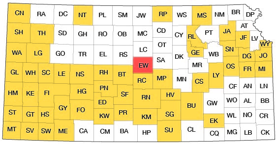
Location--Ellsworth County is located near the center of Kansas; in fact, the geographic center of the State is only a few miles west of the southwest corner of the county (Schoewe, 1948). Ellsworth County comprises Tps. 14 to 17 S. and Rs. 6 to 10 W. and has an area of about 720 square miles. It is bounded by Lincoln County on the north, Saline and McPherson counties on the east, Rice County on the south, and Barton and Russell counties on the west.
Figure 1 shows the area discussed in this report and other areas in the State for which ground-water reports have been published or are in preparation.
Figure 1--Index map of Kansas showing area described in this report and areas covered by other online geologic reports, as of Sept. 2008. For additional information, please visit the KGS Geologic Maps of Kansas Page.
Climate--Ellsworth County lies on the western margin of the subhumid climatic zone (Trewartha, 1941). The area is characterized by a predominance of sunshine, moderate precipitation, moderate wind velocity, and a relatively high rate of evaporation. During the summer, days are hot with, generally, short periods in midsummer in which the maximum daily temperature exceeds 100°F. These days are generally moderated by persistent winds and low humidity. In the fall, days are pleasantly warm with cool nights. Winters are fairly moderate with sporadic snowfalls of variable intensity and generally only short periods of severely cold weather. Spring generally is the period of maximum precipitation.
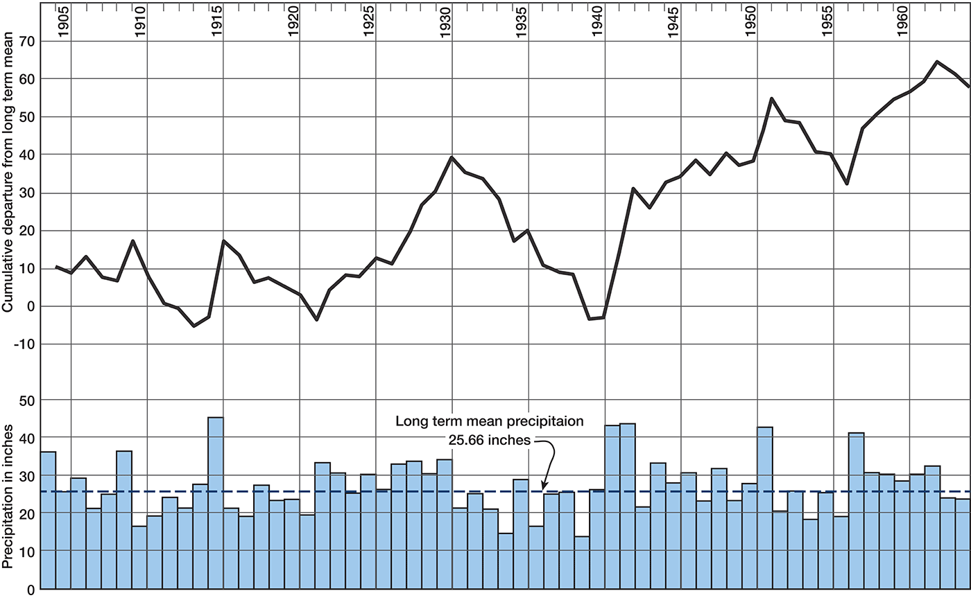
Figure 2 shows the mean monthly precipitation for Ellsworth based on U.S. Weather Bureau records for the Ellsworth station, which has reported continuously since its establishment in 1904. The annual precipitation and the cumulative departure from long-term mean precipitation for the years since 1931 are shown on figure 3. January is generally the coldest month, with a mean temperature of 30.5°F, whereas July is commonly the hottest month, with a mean temperature of 82.2°F. The average length of the growing season is 176 days, the average date of the last killing frost is April 24, and the average date of the first killing frost is October 17.
Figure 2--Long-term mean monthly precipitation and average growing season at Ellsworth.
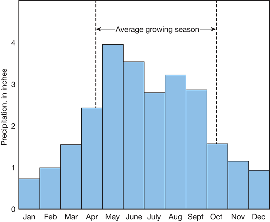
Figure 3--Annual precipitation and cumulative departure from long-term mean precipitation at Ellsworth.
Land forms--Ellsworth County lies within the Blue Hills and Smoky Hills physiographic subdivisions of the Dissected High Plains section of the Great Plains physiographic province (Schoewe, 1949). Schoewe regarded the Greenhorn escarpment as the boundary between these subdivisions. The Blue Hills are mesa-like with flat surfaces and steep, often benched, slopes. The Smoky Hills are maturely dissected hills and mounds capped by resistant sandstone bodies of the Dakota Formation. The topographic forms resulted from dissection of an older erosional plain that probably included the entire county. The area is presently in an early-mature stage of geomorphic development.
The highest point in the county, 1,920 feet above mean sea level, is on the west county line about 10 miles north of the southwest corner of the county. This point is on the divide between the Smoky Hill River drainage and the Arkansas River drainage. The lowest point in the county, 1,420 feet, occurs on the Smoky Hill River where it enters McPherson County.
Drainage--Drainage of Ellsworth County is divided among three river systems. The Saline River drains a large northeastern area, the Smoky Hill River occupies the center of the county and has the largest watershed, and the Arkansas River receives the runoff from the southwest part of the county. Thus, part of the divide between the large watersheds of the Kansas River and the Arkansas River extends across southwestern Ellsworth County.
The drainage pattern in Ellsworth County is dendritic (tributaries extend from main streams as do branches on a tree). Examination of the drainage pattern on 7 1/2-minute topographic quadrangle maps shows a number of tributaries that turn to enter trunk streams at angles greater than normal for a dendritic pattern. Several of these obviously result from stream piracy. Valleys are fairly wide and shallow throughout most of the county, but streams have cut some rather deep canyons in areas of thick sandstone bodies. Other stream-pattern peculiarities seem to result from diversion of the stream upon encountering resistant sandstone bodies in the Dakota Formation. Streams tributary to the Saline River appear to be gaining drainage area at the expense of the Smoky Hill watershed.
Most of the streams are intermittent; that is, they carry water during and for a time after rainfall. During the summer even the trunk streams often have only standing pools of water.
History and Culture
Ellsworth County and the town of Ellsworth were organized in 1867 and named for Fort Ellsworth, which was named for Lieutenant Allen Ellsworth, the commander of the military party that established the fort in June 1864 (Andreas, 1883). Fort Ellsworth was abandoned in 1866, and the larger Fort Harker was established about 1 mile northeast. Fort Harker was abandoned by the Army in 1873.
The 1960 census lists the population of Ellsworth County as 7,677 with the population of the communities as follows: Ellsworth, 2,361 [2,965 in 2000]; Wilson, 905 [799 in 2000]; Holyrood, 737 [464 in 2000]; Kanopolis, 732 [543 in 2000]; and Lorraine, 157 [136 in 2000]. [Note: Ellsworth County population was listed as 6,525 in 2000 U.S. census (KU Institute for Policy & Social Research).]
Between 1940 and 1965, the county population decreased by 2,178. Most of the decrease was in rural population, but Ellsworth and Holyrood increased in population during this period. The increase was about equal to the loss of the other towns in the county during the same period.
Previous Geologic Investigations
Probably the first stratigraphic studies in Ellsworth County were by Hawn (1858), who assigned a Triassic age to the strata now called Dakota Formation. Logan (1897) studied several exposures of the Dakota in Ellsworth County. Gould (1901) summarized the history of investigation of the "Dakota Group" and attendant controversies and described the stratigraphy of these beds in Kansas and Nebraska. Exposures in Ellsworth County were among those discussed by Gould. In his report, Twenhofel (1924) mentions observations made on the Saline County-Ellsworth County line, and he apparently collected fossils from "Mentor beds" in southeastern Ellsworth County. Tester (1931) described the lithology of several "Dakota" outcrops in Ellsworth County and theorized concerning the depositional environment of these rocks. Many details of the pre-Greenhorn Cretaceous strata observed in test pits dug for clay sampling were related by Plummer and Romary (1942). They subdivided the Dakota Formation into the Janssen Clay and Terra Cotta Clay Members, both named from type exposures in Ellsworth County. The lithology and paleontology of a Pleistocene terrace along part of the Smoky Hill River including Ellsworth County were presented by Frye and others (1943). Frye and Brazil (1943, p. 22) published a section of lower Greenhorn Limestone, Graneros Shale, and upper Dakota Formation measured on the south slope of the Smoky Hill River valley south of Wilson. Frye (1945) recorded the occurrence of Pliocene rocks in the area and recounted the Pleistocene erosional history of central Kansas using the "algal limestone" as datum. Swineford (1947) studied cemented sandstones of the Dakota and Kiowa Formations at several localities.
A summary of ceramic testing of Dakota clays by Plummer and Romary (1947) included several measured sections and photographs of outcrops in Ellsworth County. They studied samples from 102 test-pit locations in the county to verify stratigraphic conclusions reached in their publication. In his report on coal resources of the Kansas Cretaceous, Schoewe (1952) delineated parts of Ellsworth County where lignite is found. Plummer and others (1954) studied ceramic properties of four distinct Dakota clay beds of which two were in Ellsworth County. These studies resulted in the development of new industry in the county.
Methods of Investigation
During the field work for preparation of this report and the geologic map, contacts were mapped on 7 1/2-minute topographic quadrangle sheets and vertical aerial photographs and then were transferred to a base map at a scale of 1:48,000 prepared by the Topographic Division of the U.S. Geological Survey.
Many exposures were examined and many sections were measured with tape and hand level. One hundred twenty test holes and auger holes were drilled for geologic and ground-water information and are incorporated in the report. Data for 311 wells and springs are given in table 6 and include depth of well and depth to water level. Information relating to the yield and adequacy of the wells was obtained from the owners when it was available. Location of wells and test holes was determined from aerial photographs and 7 1/2-minute topographic sheets.
Samples of water from 29 wells were analyzed by the laboratory of the Environmental Health Services, Kansas State Department of Health.
Well-Numbering System
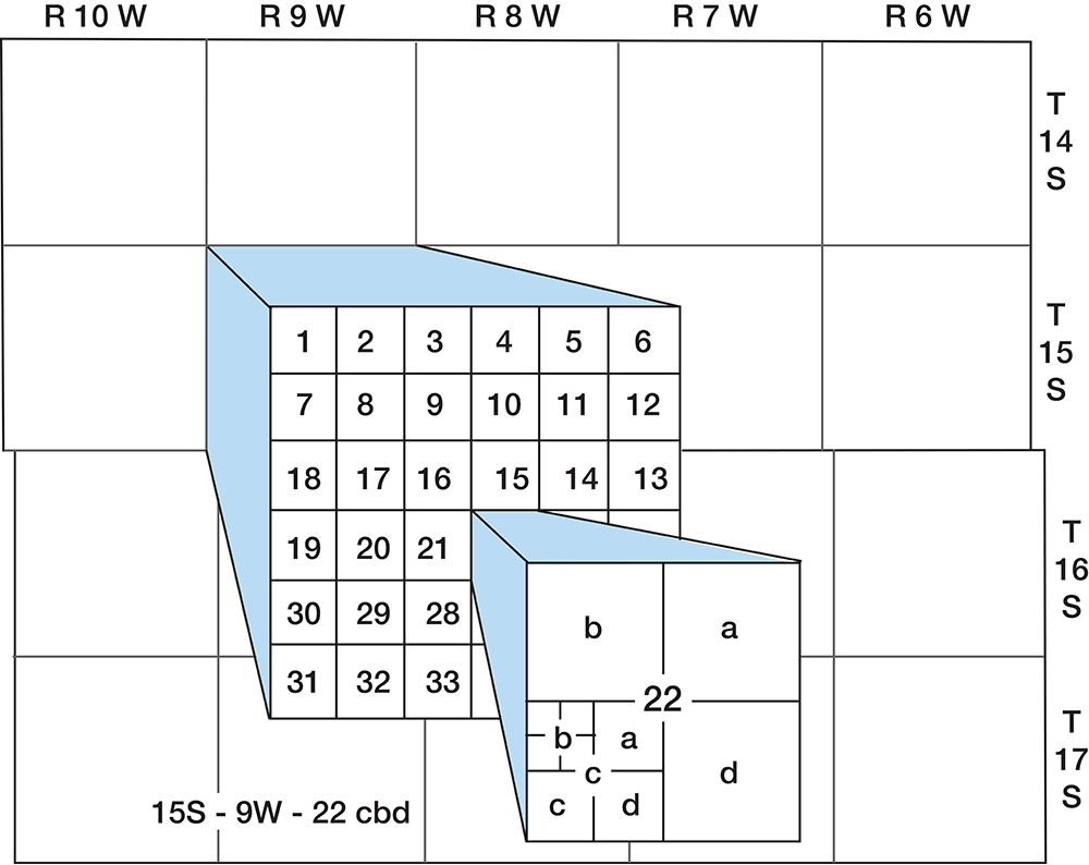
The well and test-hole numbers used in this report give the location of wells according to General Land Office surveys. The well number is composed of township, range, and section numbers, followed by letters that indicate the subdivision of the section in which the well is located. The first letter denotes the quarter section; the second letter, the quarter-quarter section or 40-acre tract; and the third letter, when used, the quarter-quarter-quarter section or 10-acre tract. The 160-acre, 40-acre, and 10-acre tracts are designated a, b, c, and d in a counterclockwise direction, beginning in the northeast quadrant. As an example, well 15-9W-22cbd is in the SE NW SW sec. 22, T. 15 S., R. 9 W. (fig. 4). When two or more wells are located within a 10-acre tract, the wells are numbered serially according to the order in which they were inventoried.
Figure 4--Well-numbering system used in this report.
Acknowledgments
The authors are deeply grateful to many residents and landowners for their interest, courtesy, and cooperation during the work in Ellsworth County and wish to especially thank the following: Mr. and Mrs. Ernest Jiricek and Representative George Jelinek, Ellsworth; Aldon Annis and Winfred Holmes, Acme Brick Co., Kanopolis; Joe Jazek and Dallas Boeken, Holyrood; and V. L. Maxey, Resident Ranger, Lake Kanopolis.
Norman Plummer of the State Geological Survey of Kansas staff first introduced the junior authors to the Kiowa and Dakota formations of central Kansas. We all are indebted to him for time spent in the field with us and for time spent in discussion.
Prev Page--Contents || Next Page--Stratigraphy
Kansas Geological Survey, Geology
Placed on web Sept. 18, 2008; originally published March 1971.
Comments to webadmin@kgs.ku.edu
The URL for this page is http://www.kgs.ku.edu/General/Geology/Ellsworth/02_intro.html