![]()
Prev Page--Introduction || Next Page--Subsurface rocks
Geography
Physiography and Topography
Brown County is in the Dissected Till Plains section of the Central Lowlands Province (Schoewe, 1949). Northeastern Kansas was invaded by ice during two glaciations. The first may have entered Brown County, but it did not cover the entire county. During the second glaciation, ice covered all of Brown County, and the present landscape is the result of this glaciation and subsequent erosion. The glaciers left a mantle of glacial drift of variable thickness over the entire County, and the typical bedrock-controlled topography of the Osage Cuesta section south of this area is entirely lacking in Brown County.
Interstream areas are relatively smooth, broad, well-rounded remnants of the original ground-moraine topography left by the melting ice as the glacier retreated. Nearer to the major drainageways, the area is more dissected, the surface reduced to gentle slopes, and the valleys wide and open. Adjacent to the larger streams the surface is highly dissected into a rough, hilly topography. Most bluffs are very steep and ledges of limestone, sandstone, and shale crop out.
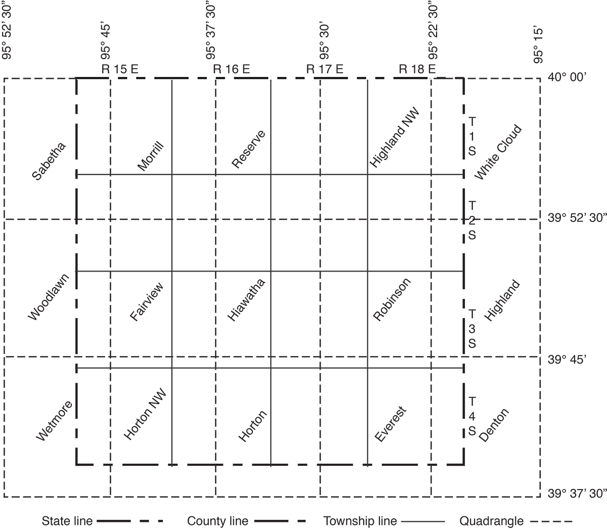
The highest point in the county, near the west border about 6 miles south of the Kansas-Nebraska line, is 1,330 feet above sea level. The lowest, about 850 feet above sea level, is in northeastern Brown County near the junction of the Nemaha River and Roys Creek. The names and locations of 7 1/2-minute topographic quadrangles covering the county are shown in Figure 3.
Figure 3--Map of Brown County, Kansas, showing names and locations of quadrangle sheets.
Drainage
The southeastern and east-central part of Brown County is drained by Wolf River, a tributary of the Missouri River. Southwestern and south-central Brown County are drained by the Delaware River, a tributary to the Kansas River. The northern part of Brown County is drained by Pony Creek, Walnut Creek, and Roys Creek, all of which are tributary to the Nemaha River.
Climate
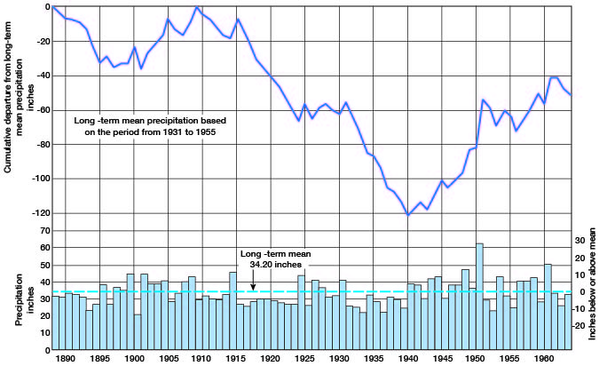
Brown County has a humid climate. A 75-year record of weather data covering the period 1889 to 1963 is available from the U.S. Weather Bureau station near Horton. The average annual precipitation for the period of record is 33.53 inches. In 44 of the years the precipitation was below average, and in 31 of the years the precipitation was above average. About 79 percent of the precipitation falls during the growing season of April through October. The monthly mean precipitation for the period 1931 to 1955 is given in Table 1, and the annual precipitation and the departure from the long-term mean Precipitation are shown in Figure 4.
Table 1--Monthly mean precipitation at Horton, Kansas.
| Month | Precipitation, inches |
|---|---|
| January | 0.99 |
| February | 0.98 |
| March | 2.03 |
| April | 3.03 |
| May | 4.66 |
| June | 6.14 |
| July | 3.13 |
| August | 4.38 |
| September | 3.82 |
| October | 2.15 |
| November | 1.59 |
| December | 1.30 |
| Total | 34.20 |
Figure 4--Annual precipitation and departure from the long-term mean precipitation at Horton, Kansas.
The summers are generally hot. The mean annual temperature is 53.3° F. The winters are characterized by brief severe cold periods. The lowest temperature of record was -25° F on February 12, 1899, and on December 5, 1924. The highest temperature of record, 112° F, occurred on August 13, 1936.
The average date of the latest killing frost is April 19, and the average date of the earliest killing frost is October 15. The average growing season is 179 days.
Population
The population of Brown County, according to the 1960 census, was 13,229, a decrease of 9.7 percent from that in 1950. Urban areas increased 2.9 percent during this period, while rural, areas decreased 13.4 percent. The population density is 22.9 persons per square mile compared to the State average of 26.6. [Note: Brown County population was listed as 10,724 in 2000 U.S. census, ranking 40th, with a density of 18.8 (32.9 for the state) (KU Institute for Policy & Social Research).]
The 1960 population of the 10 incorporated cities was: Everest, 348 [134 in 2000]; Fairview, 272 [271 in 2000]; Hamlin, 99 [53 in 2000]; Hiawatha, 3,391 [3,417 in 2000]; Horton, 2,361 [1,967 in 2000]; Morrill, 299 [277 in 2000]; Powhattan, 128 [91 in 2000]; Reserve, 138 [100 in 2000]; Robinson, 317 [216 in 2000]; and Willis, 109 [69 in 2000].
Agriculture
Agriculture is the principal source of income in Brown County and the total income in 1959 from agricultural products was $17,000,000. The average gross income per farm was about $10,000, which is about the average of the State as a whole.
Mineral Resources
Oil and Gas
Oil was produced from two wells in the Livengood field in northwestern Brown County during 1964. Production is from the Hunton group of Devonian and Silurian ages at a depth of about 2,580 feet. The field was discovered in 1944 and cumulative production is 104,060 barrels (Oros and Beene, 1965). Gas has not been found in commercial quantities in the county. [Cumulative production as of the end of 2009 was 206,357 barrels of oil, with no recent production. Additional information can be found at the oil and gas page of the Kansas Geological Survey.]
Construction Materials
Concrete aggregate--Material suitable for use as concrete aggregate is present in limited quantities in Brown County, but it is not produced commercially. The known reserves of sand and gravel generally contain too much silt to make good concrete aggregate. Most of the limestone is unsuitable for commercial use.
Structural stone--Structural stone is present in limited quantities in Brown County but is not produced commercially. South of Brown County the Cottonwood Limestone Member of the Beattie Limestone is suitable as structural stone, but in Brown County this limestone is softer and is not as resistant to weathering as it is in the central part of the state and, therefore, is not used extensively.
Road metal--Glacial outwash sand and gravel is produced from several pits in Brown County for use as road metal. In some of these pits glacial boulders are present, which limits the usefulness of this material. In northwestern Brown County chert gravel deposits are locally present in the highest uplands. These are more uniform in size than the glacial outwash gravel and generally do not contain boulders. They are used extensively for road metal in the northwestern part of the county.
Crushed stone from the Grenola Limestone and the Dover Limestone Member of the Stotler Limestone have been used for road metal, although good quarry sites are limited in the county.
Loess for use as a mineral filter in road metal is available in unlimited quantity in the northeast quarter of the county.
Coal
An estimated 100,000 tons of Elmo coal have been mined in Brown County. The Elmo coal bed occurs near the top of the Cedar Vale Shale Member of the Scranton Shale. Although coal is no longer mined in the county, potential reserves estimated at 679,400,000 tons are present (Schoewe, 1946).
Prev Page--Introduction || Next Page--Subsurface rocks
Kansas Geological Survey, Geology
Placed on web May 29, 2009; originally published May 1967.
Comments to webadmin@kgs.ku.edu
The URL for this page is http://www.kgs.ku.edu/General/Geology/Brown/03_geog.html