![]()
Prev Page--Contents || Next Page--Geography
Introduction
Purpose of Investigation
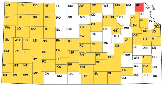
A program of investigation of the ground-water resources of Kansas was begun in 1937 by the U.S. Geological Survey and the State Geological Survey of Kansas in cooperation with the Environmental Health Services of the Kansas State Department of Health and the Division of Water Resources of the Kansas State Board of Agriculture. The investigation upon which this report is based was begun in the summer of 1960 and completed in the fall of 1962. The present status of other investigations in Kansas is shown in Figure 1.
Figure 1--Index map of Kansas showing area described in this report and areas covered by other online geologic reports, as of May 2009. For additional information, please visit the KGS Geologic Maps of Kansas Page.
Ground water is one of the principal natural resources of Brown County. Nearly all domestic and industrial supplies are obtained from ground water. It is the source of water supply for all cities in the county except Horton, which utilizes a surface-water supply.
At the present rate of withdrawal, much of the area has an adequate supply of ground water available, but local areas experience shortages during periods of prolonged drought. Therefore, knowledge of the quantity and quality of the available water supplies and the location of additional supplies is important.
Location and Extent of Area
Brown County is in the northern tier of counties and is the second county west of the east border of the State. It is bounded on the north by Richardson County, Nebraska, on the east by Doniphan County, Kansas, on the south by Atchison and Jackson counties, and on the west by Nemaha County. The county contains 576 square miles.
Previous Investigations
Although many reports have described rocks of the same age as those in Brown County and many have made specific reference to Brown County, only two reports, one by Schoewe (1938) and one by Fishburn and Davis (1962) describing the occurrence of celestite, are wholly concerned with Brown County.
Lee (1943) described the stratigraphy and structural development of the Forest City Basin. Moore (1936 and 1949) described the stratigraphy of the Pennsylvanian rocks in Kansas, including those in Brown County. Mudge and Yochelson (1962), in a report on the stratigraphy and paleontology of the uppermost Pennsylvanian and lowermost Permian rocks, referred to the rocks in Brown County; and Mudge, et al. (1959), in a report on the geology and construction-material resources in Nemaha County, described rocks which crop out in Brown County.
Frye and Walters (1950) studied glacial de- posits in northeastern Kansas. A report by Frye and Leonard (1952) describing the Pleistocene geology of Kansas mentions localities in Brown County, and Schoewe (1946) described the coal resources of the Wabaunsee Group in the county. A report on the geology and ground-water resources of Jackson County, Kansas, by Walters (1953) described rocks and ground-water conditions in Jackson County which are similar to those in Brown County, and Frye (1941) described ground-water conditions in Atchison County adjacent to Brown County.
Methods of Investigation
Field work in Brown County was begun by Schoewe in 1930. Further work by Schoewe was done on water supplies in 1934 in connection with the Kansas Emergency Relief Commission. Field work was begun by Bayne in Brown County in June 1960 and continued through October. Additional field work was done by Bayne in both 1961 and 1962. During the investigation, 130 wells were inventoried and other information was obtained. In 1960, 226 holes were angered for geologic and hydrologic information. Thirteen test holes were drilled by the State Geological Survey of Kansas with an hydraulic rotary drilling machine in areas where Paleozoic rocks were too deep to reach with the auger. In the preparation of this report, one driller's log of a public-supply well and logs of six holes drilled in 1948 and one drilled in 1957 were used.
The geology was mapped on areal photographs in the field and transferred to a base map modified from topographic quadrangle sheets.
During the investigation, 22 samples of water were collected and analyzed for the mineral content. Analyses of six samples previously collected and nine samples from municipal supplies are included in the report. All analyses were made by the Environmental Health Services Laboratory of the Kansas State Department of Health under the supervision of Howard Stoltenberg, chief chemist.
Well-numbering System
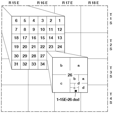
The well and test-hole numbers in this report give the location of the wells and test holes according to the system of subdivision of the public lands by the U.S. Bureau of Land Management. The first numeral of the well number indicates the township, the second number indicates the range, and the third number indicates the section. The quarter sections (160 acres), quarter-quarter sections (40 acres), and the quarter-quarter-quarter sections (10 acres) are designated a, b, c, or d in a counterclockwise direction beginning in the northeast quadrant (Fig. 2). For example, well 1-15E-26dcd is in the SE SW SE sec. 26, T 1 S, R 15 E. If two or more wells are located in the same 10-acre tract, the location number is followed by serial numbers in the order in which they were inventoried.
Figure 2--Sketch of Brown County, Kansas, illustrating the well-numbering system used in this report. Location is section 26, T 1 S, R 15 E, showing the method of dividing sections into quarter sections, quarter-quarter sections, and quarter-quarter-quarter sections.
Acknowledgments
Appreciation is expressed to the many residents of Brown County who supplied information on their wells and aided in the collection of field data. Special acknowledgment is due city officials who supplied information about municipal water supplies and to S. M. Ball, of the State Geological Survey of Kansas, for aid in stratigraphic work.
This report has been reviewed by members of the U.S. Geological Survey and the State Geological Survey of Kansas; R. V. Smrha, Chief Engineer, and H. L. Mackey, Engineer, Division of Water Resources, Kansas State Board of Agriculture; and J. L. Mayes, Chief Engineer, and B. F. Latta, Geologist, of the Environmental Health Services of the Kansas State Department of Health.
Prev Page--Contents || Next Page--Geography
Kansas Geological Survey, Geology
Placed on web May 29, 2009; originally published May 1967.
Comments to webadmin@kgs.ku.edu
The URL for this page is http://www.kgs.ku.edu/General/Geology/Brown/02_intro.html