![]()
Prev Page—Chemical Character || Next Page—Records of Typical Wells
Ground Water, continued
Ground-water Conditions by Areas
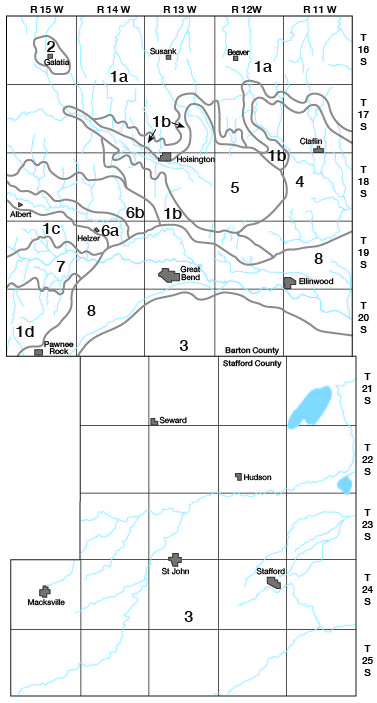
On the following pages the ground-water conditions in Barton and Stafford Counties are described by areas that are classified primarily on the basis of geologic source and depth to water level. The eight major areas are (1) the upland and terrace areas of Barton County in which the principal source of water is the Dakota formation; (2) the Galatia upland area, in which most of the wells tap the Ogallala (?) formation; (3) the Great Bend prairie area; (4) the Claflin terrace area; (5) the Cheyenne Bottoms-Blood Creek Valley area; (6) the Walnut Valley and terrace area; (7) the Dry Walnut Valley area; and (8) the Arkansas Valley area (Fig. 18). The upland and terrace areas of Barton County in which the principal source of ground water is the Dakota formation have been subdivided into the (1a) Olmitz-Susank-Beaver upland area; (1b) Hoisington area; (1c) Albert-Heizer upland area; and (1d) the Pawnee Rock upland area. The Walnut Valley area has been divided into the valley proper (6a) and the Walnut Valley terrace area (6b).
Figure 18—Ground-water areas in Barton and Stafford counties. 1a, Olmitz-Susank-Beaver upland area; 1b, Hoisington area; 1c, Albert-Heizer upland area; 1d, Pawnee Rock upland area; 2, Galatia upland area; 3, Great Bend prairie area; 4, Claflin terrace area; 5, Cheyenne Bottoms-Blood Creek Valley area; 6a, Walnut Valley area; 6b, Walnut Terrace area; 7, Dry Walnut Valley area; and 8, Arkansas Valley area.
Olmitz-Susank-Beaver upland area
The Olmitz-Susank-Beaver upland area comprises most of the uplands in the northern half of Barton County and is underlain by the Carlile shale and Greenhorn limestone (Fig. 18 and Plate 1). About two-thirds of the wells in this area are deep wells that derive water from sandstones in the Dakota formation. These wells range in depth from about 35 to 275 feet, but most of them are 150 to 275 feet deep. The water level in them stands 18 to 203 feet below the surface, although in most of them it is between 100 and 200 feet. Adequate supplies of water for domestic and stock use can be obtained from the Dakota formation almost everywhere in the Olmitz-Susank-Beaver area. In some places, however, the water is highly mineralized and unfit for many uses (p. 131). Chloride is the most objectionable constituent in these highly mineralized waters. Of 17 samples of water collected from the Dakota formation in this area, 6 contained more than 1,000 parts per million of chloride and most of them were high in iron and fluoride.
A few shallow wells in the Olmitz-Susank-Beaver upland area obtain small supplies of water for domestic and stock use from the Greenhorn limestone or Carlile shale, or from alluvium in some of the small valleys. Supplies from these sources in many places are inadequate even for domestic or stock use. The depth of the wells in alluvium ranged from 9 to 19 feet, those in the Carlile shale ranged from 20 to 48 feet, and those in the Greenhorn limestone ranged from 23 to 124 feet.
Large supplies of water are not available anywhere in the Olmitz-Susank-Beaver upland area, and locally it is difficult to obtain adequate water of good quality even for domestic or stock use.
Hoisington area
The Hoisington area comprises two separate areas (1b, Fig. 18). The one is a narrow strip, 0.25 to 2 miles wide, that includes the dissected slopes between the uplands of northern Barton County and the low areas of Blood Creek, Cheyenne Bottoms, and the Claflin terrace area. The other part of the Hoisington area is the divide area that separates Cheyenne Bottoms and Blood Creek from the Arkansas Valley and the Walnut Valley terrace. The surface formations in the Hoisington area include the Dakota formation, Graneros shale, and Sanborn formation.
All the 20 wells in this area for which records were obtained are small domestic and stock wells that tap the Dakota formation. They range in depth from 30 to about 90 feet and the depth to water level in them ranges from 15 to 78 feet below the surface. Samples of water from seven wells (17-12-2cb, 17-13-10dd, 17-13-31dd, 17-14-33dd, 18-12-12bc, 19-12-15dd, and 19-13-11cb) in the Hoisington area were collected and analyzed. The dissolved solids in these samples ranged from 330 (well 18-12-12bc) to 2,174 parts per million (well 17-13-31dd) and the hardness ranged from 272 (well 18-12-12bc) to 626 parts (well 19-13-11cb). The chloride was high in only one sample (well 17-13-31dd)—1,030 parts per million.
Adequate water of satisfactory quality for domestic and stock use is available from the Dakota formation almost everywhere in the Hoisington area.
Albert-Heizer upland area
The Albert-Heizer upland area comprises the hilly divide between Walnut Valley and Dry Walnut Valley in west-central Barton County (Fig. 18 1c). The northern and highest part of this area is underlain, from west to east, by the Greenhorn limestone, Graneros shale, and Dakota formation. In the south part of the area these formations are covered by a comparatively thin mantle of terrace deposits of the Sanborn formation.
Records were obtained for eight domestic and stock wells (19-14-7dd, 19-14-16bb, 19-15-2ad, 19-15-3dc, 19-15-6ab, 19-15-7cd, 19-15-13ad, and 19-15-17cb) in this area, all but one (well 19-15-6ab) of which derive water from sandstones of the Dakota formation. Well 19-15-6ab is an unused domestic dug well, 23 feet deep, in the Greenhorn limestone. The water level in this well stands 11 feet below the surface. The depths of the seven wells in the Dakota formation range from 56 to 99 feet and the depths to water level in them range from 25 to 61 feet below the surface. An analysis of a sample of water from well 19-14-7dd showed it to be moderately hard but otherwise of good chemical quality.
Pawnee Rock upland area
The upland and terrace areas separating Dry Walnut Valley from Arkansas Valley in the southwestern corner of Barton County are here referred to as the Pawnee Rock upland area. This is a dissected area having moderate to steep slopes. The highest or west-central part of the area is underlain by the Greenhorn limestone, Graneros shale, and Dakota formation. The Dakota formation is also exposed in the bluff of Arkansas Valley above Pawnee Rock. Elsewhere in the Pawnee Rock upland area, the dissected surface of these formations is covered by from less than 10 to about 60 feet of silt and sandy silt of the Sanborn formation.
All but one (well 19-15-32db) of the nine recorded wells in the Pawnee Rock upland area are in the upper part of the Dakota formation. Well 19-15-32db, which is a small stock well 37 feet deep, obtains its water from a thin lens of sand and gravel in the lower part of the Sanborn formation. Wells 20-15-17bc and 20-15-19dd in the highest or west-central part of the area are 146 and 163 feet deep, respectively, and the water levels in them are 105 and 89 feet below the surface. Elsewhere, the depths of the wells penetrating sandstones in the upper part of the Dakota formation range from 40 to 84 feet and the depths to water level range from 12 to 62 feet. The analyses of two samples (20-15-19dd and 20-15-22ba) of water indicate that the waters in the Dakota formation in this area are hard but otherwise of satisfactory quality for most uses.
Small to moderate yields are available to wells in the Pawnee Rock upland area. Most of the existing wells are small wells drilled to supply water for domestic and stock use. Although no detailed record is available for it, a well drilled in 1947 for compressor water at a gas booster station in the SE SW sec. 6, T. 20 S., R. 15 W., had a reported yield of about 75 gallons a minute. The reported depth of this well is 250 feet. Similar yields could probably be obtained from deep wells in other parts of this area.
Galatia upland area
The Galatia upland area comprises about 6 square miles in the vicinity of Galatia in northwestern Barton County (Fig. 18, area 2). It is an elongate area trending northwest-southeast that is situated on the high divide separating tributaries of Arkansas River drainage from those of Smoky Hill River drainage. The surface is nearly flat around Galatia and has gentle to moderate slopes around the borders of the area. Unconsolidated clay, silt, sand, and some gravel of early Pleistocene age, ranging in thickness from about 10 to 40 feet, overlie the dissected surface of the Carlile shale and form the surface rock in the Galatia upland area.
Most of the wells in this area are shallow wells that obtain small supplies of water from relatively thin deposits of sand and gravel at the base of the Pleistocene deposits. The five recorded wells (16-15-15dc1, 16-15-15dc2, 16-15-16da, 16-15-22dc, and 16-15-25bc) range in depth from 10 to 40 feet and the water levels in them range from 7 to 32 feet below the surface. An analysis of a sample of water from well 16-15-15dc2 shows it to be a relatively soft sodium chloride water. It had a hardness of 73 parts per million and contained 1203 parts of dissolved solids, 460 parts of chloride, 1.2 parts of iron, and 2.2 parts of fluoride.
All existing wells in the Galatia upland area are domestic and stock wells having small yields. Supplies of water adequate for irrigation or industrial use probably are not available in this area.
Great Bend prairie area
The area covered by the Great Bend prairie is the same area as described in the section on physiographic divisions under the same name (pp. 44-48.) The Great Bend prairie includes all of Stafford County and that part of Barton County lying south of the Arkansas Valley. Nearly all the wells in the Great Bend prairie obtain water from sand and gravel deposits of the Meade formation, which underlies the surface or is found at shallow depth beneath younger deposits everywhere in the area. A complete description of the thickness and water-bearing characteristics of the Meade formation is given on pages 68-71 of this report.
The Meade formation furnishes water to all irrigation, public-supply, industrial, and most of the domestic and stock wells in the Great Bend prairie. These wells range in depth from about 15 to 116 feet, but most of them are between 25 and 75 feet deep. The water table is shallow, being less than 25 feet below the surface everywhere except beneath the highest sand dunes. In the valleys of Rattlesnake Creek and the North Fork of Ninnescah Creek and in the marshes the water table is generally less than 10 feet below the surface and at a few wells (22-11-9bb, 22-11-10cc, 22-11-35ab, 22-12-12db, and 23-13-3aa) in northeastern Stafford County local artesian conditions exist and the head is above the surface (pp. 88-90). A few shallow domestic and stock wells (21-11-22cb, 21-11-26ad, 22-11-3cd, 23-11-1bc, 23-12-2cd, and 24-14-1aa), less than 15 feet deep, obtain water from alluvium in Rattlesnake Valley and Big Marsh.
Ground water in the Meade formation beneath the Great Bend prairie is everywhere moderately hard, but in most places it is suitable for domestic, stock, irrigation, and public-supply use. In northeastern Stafford County the ground water locally is highly mineralized and is not satisfactory for most uses. In some parts of the Great Bend prairie, water in the lower part of the Meade formation is too highly mineralized for most uses, but in these areas most wells obtain adequate water of good quality from the upper part of the Meade formation.
The sands and gravels of the Meade formation beneath the Great Bend prairie are highly permeable and capable of yielding large supplies of water to properly constructed wells. The yields of existing wells in this area range from a few gallons a minute for the small driven domestic and stock wells to nearly 1,000 gallons a minute for the larger irrigation wells.
Claflin terrace area
The Claflin terrace area includes approximately the same area as the Cow Creek drainage basin (Fig. 8), the areal extent and physiographic features of which have been described on pages 40-42.
The Sanborn formation underlies most of the surface of this area and is the principal water-bearing formation. In the west-central part of the Claflin terrace area the Sanborn formation is overlain by dune sand. The Sanborn formation rests on the dissected surface of the Dakota formation everywhere in this area.
Twenty-two of the 24 recorded wells in the Claflin terrace area end in the Sanborn formation. These are small domestic and stock wells having small to moderate yields. They range in depth from about 20 feet to about 95 feet. The depth to the water table ranges from less than 10 feet in the valleys of Little Cheyenne and Cow Creeks to about 60 feet beneath the higher hills in the northern part of the area. The analyses of five samples (17-11-31dc, 17-11-36CC, 18-11-15bC, 19-11-6dd, and 19-12-13ad) of water from wells in the Claflin area indicate that the water in the Sanborn formation is moderately hard to hard, but otherwise is of satisfactory quality for ordinary uses. The most highly mineralized water (sample 19-12-13ad) contained 1,502 parts per million of dissolved solids and 560 parts of chloride, and had a hardness of 606 parts.
Wells 18-11-4ad1 and 18-11-45d2 in the Claflin terrace area are public-supply wells that furnish water to the City of Claflin. They are about 160 feet deep and derive water from sandstones in the Dakota formation. The static water level in them stands about 32 feet below the surface. Well 18-11-45d1 is reported to yield 200 gallons a minute with a 30-foot drawdown. The water is of good chemical quality (analysis 18-11-4ad1, Table 8).
Cheyenne Bottoms-Blood Creek Valley area
Descriptions of Cheyenne Bottoms and Blood Creek Valley are given in the section on physiography (p. 40). Nearly all the wells in this area derive water from alluvial deposits at relatively shallow depth. The water table is everywhere less than 20 feet below the surface, and in many places it is less than 10 feet.
The depths of 15 recorded domestic and stock wells in Cheyenne Bottoms range from 15 to 63 feet. Most of these wells have low yields because the alluvial materials that they tap are fine-grained and have low permeability. The water from the alluvium beneath Cheyenne Bottoms in many places is of poor quality. Four samples (17-12-31dc, 18-11-19bb, 18-13-15da, and 19-12-6bc) of water from wells in the alluvium of this area contained 449 to 2,728 parts per million of dissolved solids and had 310 to 904 parts of hardness. A few wells in the Bottoms, especially near the edge where the alluvium is thin, may obtain water from the underlying Dakota formation. A shallow well in alluvium (17-12-31dc), 27.5 feet deep, in the SW SE sec. 31, T. 17 S., R. 12 W., was replaced by a deeper well (17-12-31dc) in the Dakota formation because of the hardness of the shallow water. Water from the shallow well (17-12-31dc) contained 1,272 parts per million of dissolved solids and had a hardness of 795 parts. Water from the well in the Dakota (17-12-31dc), which is 60 feet deep, contained 972 parts per million of dissolved solids and had a hardness of 499 parts.
Small to moderate supplies of water are obtained from shallow wells tapping alluvium in Blood Creek Valley. Wells 17-14-33aa, 17-14-36cb, and 18-14-1da in Blood Creek Valley are 48, 16, and 52 feet deep, respectively, and the water levels in them in 1944 were 18, 5, and 7 feet below the surface.
Walnut Valley and Terrace area
The Walnut Valley area is divided into two areas—the one comprising the valley proper (6a, Fig. 18) and the other comprising the terrace that borders the north side of the valley (6b, Fig. 18). Physiographic descriptions of these two areas are given on pages 42-43.
Walnut Valley proper is underlain by thick deposits of highly permeable sand and gravel that furnish moderate to large supplies of water to wells. The water table there is shallow, being less than 25 feet below the surface everywhere according to reports and measurements made in 14 wells in 1944. In 1944 there were eight irrigation wells (18-15-28cc1, 18-15-28cc2, 18-15-30bd, 18-15-33ad, 18-15-34aa, 18-15-36ba, 19-14-4ca, and 19-14-9aa), two industrial wells (19-14-6bb1 and 19-14-6bb2), and an unknown number of domestic and stock wells that tapped the alluvium in Walnut Valley. Most of the small drilled or driven domestic and stock wells are 30 to 60 feet deep, whereas the larger irrigation and industrial wells are 50 to 80 feet deep. The yields of the wells range from a few gallons a minute for the shallow driven wells to about 1,000 gallons a minute for the larger-diameter and deeper irrigation wells. The analyses (18-15-30dd, 18-15-34ab, and 19-14-6bb3, Table 8) of three samples of water indicate that, except for being hard, the ground water beneath Walnut Valley is of good quality.
The water-bearing materials beneath the Walnut Valley terrace area consist of terrace deposits of the Sanborn formation. They are similar to the alluvium beneath Walnut Valley proper except that the lenses of sand and gravel are not as widespread and in most places are not as permeable. In some places, particularly along the northern part of the area, little or no gravel is encountered. The depths to water level in 12 wells in this area ranged from 20 to 54 feet below the surface in 1944. All the recorded domestic and stock wells in this area tap sand or sand and gravel in the Sanborn formation and furnish small to moderate supplies of water. The depths of these wells range from 28 to 90 feet. In 1944 there was one irrigation well (19-13-6db) in the Walnut Valley terrace area, in the NW SE sec. 6, T. 19 S., R. 13 W. This well is 115 feet deep and has a reported yield of 1,100 gallons a minute. According to the driller's log (pp. 193-194), 59 feet of saturated sand and coarse gravel was encountered in well 19-13-6db between depths of 55 and 115 feet. Analyses were made of samples of water from two wells (18-14-25cb and 18-14-30cb) in the Walnut Valley terrace area. Both samples were moderately hard but otherwise of good quality and satisfactory for most ordinary uses.
Dry Walnut Valley area
The Dry Walnut Valley area (7, Fig. 18) includes the valley area occupied by Dry Walnut Creek and several short, broad reentrant valleys occupied by tributary streams (p. 43). Unconsolidated alluvial deposits consisting chiefly of clay, silt, and sandy silt but containing minor amounts of sand and gravel and ranging in thickness from 50 to 125 feet underlie this area. Most of the sand and gravel is poorly sorted and occurs at the base of the alluvial fill. The depths to water level in nine recorded wells ranged from 9 to 31 feet below the surface in 1944.
Most of the wells in this area are shallow domestic and stock wells having small yields. The depths of eight of the nine recorded wells ranged from 24 to 34 feet. One well (19-15-15bb) is 235 feet deep and obtains water from sandstones in the Dakota formation. It was drilled to supply water for drilling an oil-test well. Samples of water from wells 19-15-20aa, 19-15-24bc, and 19-15-34aa, which tap the alluvium at shallow depths, contained 271, 1,163, and 768 parts per million of dissolved solids and had 202, 342, and 452 parts of hardness, respectively.
The yields of the existing shallow wells in the Dry Walnut Valley area, although small, are adequate in most cases for domestic and stock use. Greater yields could be obtained in some places by deeper wells that penetrated the full thickness of the alluvium. It is doubtful, however, that supplies adequate for irrigation could be obtained anywhere in this area.
Arkansas Valley area
The Arkansas Valley area includes the present flood plain of Arkansas River and associated low terraces bordering the flood plain (Fig. 18 and pp. 43-44). It is an elongate area ranging in width from about 2 to 8.5 miles. The surface of this area in most places is relatively level and is underlain by unconsolidated silt, sand, and gravel (alluvium and the Meade formation) ranging in thickness from less than 50 feet to approximately 200 feet.
The depths of 49 recorded domestic, stock, irrigation, industrial, and public-supply wells in this area range from about 15 feet to 140 feet and the depths to water in them range from 2 to 26 feet below the surface. Most of these wells derive water from the alluvium or the Meade formation, or both. The yields of wells in the Arkansas Valley area range from a few gallons a minute for the small driven domestic wells to more than 1,000 gallons a minute for the larger irrigation wells. Most of the 13 recorded irrigation wells have reported yields of 1,000 gallons a minute or more. Irrigation wells 19-13-18db and 19-13-21cc have reported yields of 1,500 and 1,370 gallons a minute, respectively.
Waters from the alluvium and the Meade formation beneath the Arkansas Valley are of satisfactory quality for most uses. Five samples (19-12-28cc, 20-11-2ba, 20-11-18ba, 20-14-20bc, and 20-15-33db) of water from the alluvium contained between 508 and 898 parts per million of dissolved solids and had between 242 and 450 parts of hardness. Samples from wells 19-13-28cd, 19-13-34cd, and 19-14-33cd in the Meade formation contained, respectively, 564, 379, and 422 parts per million of dissolved solids and had 260, 237, and 286 parts of hardness. For some industrial uses these waters must be treated to reduce the hardness.
Prev Page—Chemical Character || Next Page—Records of Typical Wells
Kansas Geological Survey, Barton and Stafford Geohydrology
Web version Dec. 2001. Original publication date Dec. 1950.
Comments to webadmin@kgs.ku.edu
The URL for this page is http://www.kgs.ku.edu/General/Geology/Barton/07_gw7.html