![]()
Prev Page—Cretaceous and Tertiary || Next Page—Ground Water
Geologic History
Throughout much of Paleozoic time the Barton-Stafford County area was alternately submerged and elevated. During periods of submergence, marine sediments accumulated and were subsequently eroded during periods when the area was above sea level. Deposits laid down in early Paleozoic time consisted chiefly of marine limestone, shale, and sandstone. Prior to the deposition of Mississippian sediments, there was regional arching of the strata along a northwest-southeast axis, and subsequent erosion that truncated the earlier Paleozoic rocks and removed all of them in part of Barton County. Following this period of uplift and erosion, the sea again invaded the area and limestones and shales of Mississippian age were deposited. Sometime prior to Pennsylvanian deposition, the rocks of central Kansas were again uplifted and warped to form the structural feature now called the Central Kansas uplift, and erosion removed all the Mississippian limestone and shale from this area except in the southeastern quarter of Stafford County. The sea again invaded the area during Pennsylvanian time and marine deposits accumulated over all of central Kansas. Minor withdrawals of the sea took place during the latter part of Pennsylvanian time and during the Permian Period, at which times continental deposits were laid down. Near the end of Permian time continental deposition became predominant, forming the redbeds that are encountered below Cretaceous and younger deposits by test holes and oil wells. By the close of Paleozoic time the sea withdrew completely from the area and the surface was eroded, uplifted, and warped. Erosion probably continued throughout all of Triassic and Jurassic time, for sediment of these periods are not known to occur in Barton and Stafford Counties. For a more detailed account of the Paleozoic history of the central Kansas area the reader is referred to reports by Koester (1935) and Moore and Jewett (1942).
Cretaceous deposits were laid down on the long-eroded, deeply weathered Permian surface. During the Comanchean (Lower Cretaceous) Epoch of the Cretaceous Period the sea once more invaded this area, and clastic sediments, composed chiefly of sand but containing minor amounts of finer material, were deposited at or near the shore line of this advancing sea. These sediments make up the Cheyenne sandstone—a dominantly continental deposit. As the Comanchean sea advanced northward, all the Barton-Stafford County area was inundated, and the marine sediments composing the Kiowa shale were deposited.
A general withdrawal of the sea marked the end of Early Cretaceous time. This withdrawal of the sea was not continuous but was marked by minor re-advances that resulted in marine and continental beds being interbedded. After the retreat of the Early Cretaceous sea, continental deposits of clay and sand (Dakota formation) accumulated in stream channels, on flood plains and beaches, and in lagoons. After the deposition of the Dakota formation, the area was covered by a shallow sea, and great thicknesses of clay and limestone (Graneros shale, Greenhorn limestone, and Carlile shale) were deposited.
At the close of the Cretaceous Period, the sea withdrew and since that time the area has been continuously above sea level. During most of the Tertiary Period the surface was subject to erosion which truncated the Cretaceous rocks. Late in Tertiary time, during the Pliocene epoch, sediments of the Ogallala formation were laid down on the eroded Cretaceous surface in the region by streams carrying material from the highlands to the west.
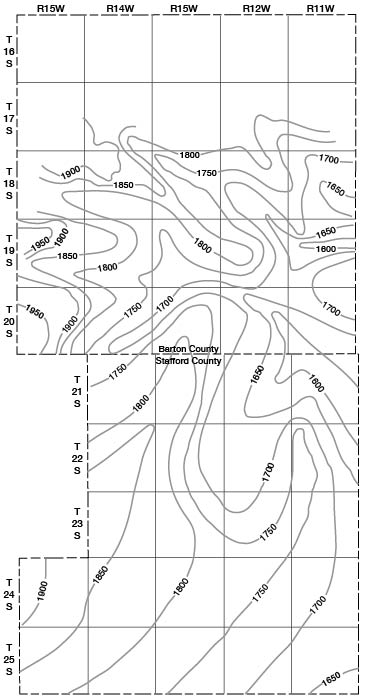
The Pleistocene history of this area is very complex and was marked by the cutting and filling of deep valleys and by major changes in drainage. Sufficient data are not available to give a detailed account of the events that took place during Pleistocene time. Erosion in late Tertiary or early Pleistocene time removed the Ogallala formation from most of the area and some of the Cretaceous rocks. Prior to the deposition of the Meade formation, erosion had removed all the Cretaceous rocks and the upper part of the Permian in parts of Stafford County and southeastern Barton County (Fig. 11). Widespread deposition of silt, sand, and gravel (Meade formation) in Stafford County and southern Barton County followed this period of erosion. These sediments were deposited by streams carrying material from the Rocky Mountains and from the areas of Tertiary rock to the west. The surface on which the Meade was deposited in Stafford County and southern Barton County was an erosional surface of hills and valleys, as shown by the contours in Figure 12. Figure 12 indicates that a large valley existed in southern Barton County in approximately the same position as the present course of Arkansas Valley. Another valley, that trends from south to north in eastern Stafford County, is shown joining this valley in the extreme southeastern part of Barton County. Deposition of sediments of the Meade formation probably started in these valley areas. During early Pleistocene time the ancestral Arkansas River, instead of following the present course around the "great bend," is thought to have flowed eastward or southeastward across south-central Kansas. At the same time the ancestral Smoky Hill River flowed southward through McPherson County and joined the ancestral Arkansas River in southern Kansas.
The early Pleistocene valley in southern Barton County is probably part of a major tributary that joined the Smoky Hill-Arkansas drainage north of Wichita. Later in Pleistocene time this tributary, through lateral shifting and a series of captures, became the major drainageway for Arkansas River from eastern Ford County to Wichita, thus forming the present "great bend."
Late in Pleistocene time erosion was resumed in the Dry Walnut, Walnut, Cow Creek, and Blood Creek-Cheyenne Bottoms Valleys and they were cut somewhat below their present depths. This was followed by the deposition of stream-laid silt, sand, and gravel in the valleys and wind-blown silt on the divides (Sanborn formation). Deposition by the wind of dune sand in Stafford and southern Barton Counties probably started at about the same time and has continued into Recent time.
Much of the present topography of Barton and Stafford Counties is the result of erosion and deposition that started during the latter part of the Pleistocene Epoch and have continued to the present time. Channels were cut in the Pleistocene valley fill and partially refilled by alluvium, leaving prominent terraces underlain by the Sanborn formation, and downcutting by relatively short tributary streams has removed more of the Cretaceous rocks in Barton County.
Origin of Cheyenne Bottoms
Two theories have been advanced to explain the origin of Cheyenne Bottoms. Haworth, who was the first to write on the subject, ascribed the formation of the Bottoms to stream erosion and quoted the following description that was credited to B. L. Miller, one of his assistants (Haworth, 1897, pp. 44-45):
"In past time the two streams, Blood Creek and Deception Creek, which are the only streams of importance entering the basin, probably flowed about as they do now. We suppose at one time their channels were cut into the Benton and the Dakota sandstones. These materials resisting erosion quite well necessarily made the deepening of their channels and the widening of their valleys slow processes. But finally, having cut through these harder strata to the softer stratum of saliferous shales beneath, the processes of erosion were greatly increased, and it was therefore a comparatively short time until the streams had cut their channels entirely through this stratum of shales to the harder layer of sandstone beneath. They now began to widen their valleys, or their valley; for the two streams probably united in one when this shale was first encountered. This widening was likewise rapid, so that a wide valley was soon formed. Had the sandstone overlying this shale bed been very hard we should doubtless have had falls produced of about 30 feet in height, which would have slowly retreated up stream. There are good reasons for believing that the point where the stream first encountered the shale bed was considerably farther east than the present limits of the basin. Evidence of this is furnished by the fact that river sands cover the surface for some distance in this direction. Thus the valley has been extending up stream as well as widening on either side. The upper courses of the two streams mentioned have not even yet reached the soft, saliferous shales, and consequently have narrow valleys.
"But while this was going on, the Arkansas River was slowly working its way northward by wearing away the soft Dakota sandstones and shales along its northern bank. As the course of the river to this point was northeast and the course of the creek to the southeast, their valleys finally met. A long, wedge-shaped ridge remains, which separates the upper courses of their valleys.
"The breaking down of so much sandstone necessarily left behind great quantities of sand. In the great quantity of sand lying to the south of this wedge-shaped mass of land and in frequent southerly winds, we have the conditions requisite for producing the present basin. The sand blown by the wind across the mouth of this valley formed a drift back of the point of this wedge between the valleys. The drift gradually increased in length and height until it became a barrier entirely across the valley of the small creek and formed a great basin. The drifting of snow often produces similar results, though on a smaller scale. Could the stream have had considerable water flowing in it continually, it might have been able to keep its channel clear; but probably there was not water enough or current strong enough to carry away the sand that drifted into the channel."
Johnson (1901, pp. 712, 713) advanced the theory that Cheyenne Bottoms was a basin of subsidence resulting from removal of soluble masses of salt within the underlying rock, but noted that the gap in the rock wall on the southeast side did not favor this theory. In 1926, Bass prepared a map of salt thicknesses in western Kansas that shows thinning of the salt beds beneath Cheyenne Bottoms (Bass, 1926, p. 90). He (Bass, 1926, pp. 94-95) believed that this evidence tended to confirm Johnson's subsidence theory.
Subsidence may have been in part responsible for the formation of Cheyenne Bottoms; however, test-drilling data gathered during the present investigation indicate that a buried stream channel exists beneath the southeast side of Cheyenne Bottoms (Fig. 12). This evidence suggests that in Pleistocene time a stream flowed across the Cheyenne Bottoms area in line with Blood Creek. From Cheyenne Bottoms it followed approximately the present course of Little Cheyenne Creek and entered Rice County through a now deeply buried channel at about the cen. E. line T. 19 S., R. 11 NW. (Fig. 12 and L-L', Pl. 3). Fent (1950) refers to this channel as the Chase channel and has traced its course through Rice County. A narrow divide in the vicinity of Ellinwood separated this channel from the ancestral Arkansas channel. After material began accumulating in the ancestral Arkansas channel, the main stream overflowed the divide and followed the Chase channel. The Cheyenne Bottoms channel became a tributary and was later choked either by accumulating sand, as suggested by Miller (in Haworth, 1897, p. 45), or because of more rapid accumulation of sediments in the main stream. Since that time, deposition in the Cheyenne Bottoms area has taken place in shallow intermittent ponds.
Figure 12—Configuration of the bedrock surface in Barton and Stafford Counties, Kansas.
Prev Page—Cretaceous and Tertiary || Next Page—Ground Water
Kansas Geological Survey, Barton and Stafford Geohydrology
Web version Dec. 2001. Original publication date Dec. 1950.
Comments to webadmin@kgs.ku.edu
The URL for this page is http://www.kgs.ku.edu/General/Geology/Barton/06_hist.html