![]()
Prev Page—Geology, Pre-Permian and Permian || Next Page—Quaternary
Geology and its Relation to Ground Water, continued
Cretaceous System
Rocks of Cretaceous age having an aggregate thickness of more than 500 feet overlie the eroded surface of Permian rocks in Barton County and most of Stafford County. Approximately the lower four-fifths of the Cretaceous section in this area consists of clay, shale, and sandstone and represents the Comanchean Series (Cheyenne sandstone and Kiowa shale) and lower part of the Gulfian Series (Dakota formation and Graneros shale). The upper part of the Gulfian (Greenhorn limestone and Carlile shale) consists chiefly of limy sediments including calcareous shale, thin chalk beds and chalky limestone.
The Cheyenne, Kiowa, and Dakota formations in central and south-central Kansas have been discussed at some length in recent reports by Plummer and Romary (1942), Swineford and Williams (1945), and Latta (1946).
Comanchean Series
Cheyenne Sandstone
The Cheyenne sandstone is not exposed in the Barton-Stafford County area, but was penetrated by several test holes drilled during the course of the investigation and by many oil wells at depths ranging from less than 50 feet near the outcrop of the Kiowa shale in northeastern Stafford County (Pl. 1) to more than 350 feet in central Barton County. It is absent in north-central and northeastern Barton County because of non-deposition and in much of eastern Stafford County where it was removed by erosion after the Cretaceous Period. Elsewhere, the Cheyenne overlies Permian rocks and is from a featheredge to more than 100 feet thick. The maximum known thickness in this area is 134 feet and was encountered in test hole 19-14-17bb about a mile southwest of Heizer.
The nearest outcrop of the Cheyenne sandstone is in the type area near Belvidere in southeastern Kiowa County. There it has an average thickness of about 45 feet and consists principally of light-colored fine- to medium-grained, friable, cross-bedded sandstone and lenses of sandy shale and conglomerate (Latta, 1946, p. 235). The material penetrated by test holes and oil wells in Barton and Stafford Counties was principally white to light-gray siltstone and white to light-gray, light pale-green, light gray-green, and gray-green, friable to tightly cemented, very fine to medium-grained sandstone. Beds or lenses of light-colored sandy clay and sandy shale are interbedded with the siltstone or sandstone, and pyrite and carbonaceous material are not uncommon.
So far as is known, no wells in Barton and Stafford Counties obtain water from the Cheyenne sandstone. Water from this formation probably would be highly mineralized. Sometime prior to 1900, a deep test well was drilled near Great Bend. At a depth of 344 feet, which would be in the Cheyenne sandstone, flowing water was encountered. The well is reported to have had a flow of 10 gallons a minute, but the water was too salty to be used (Darton, 1905, p. 291). Flowing water was also encountered in the Cheyenne sandstone in test hole 19-14-17bb in the NW 1/4 sec. 17, T. 19 S., R. 14 W. A sample of this water was analyzed for chloride and found to contain 33,000 parts per million.
Kiowa Shale
The Kiowa shale is the oldest formation exposed in Barton and Stafford Counties (Pl. 1). It is exposed in the bluff of the Arkansas Valley along the Barton-Rice County line in the eastern parts of secs. 1 and 12, T. 20 S., R. 11 W., where about 50 feet of tan to brown sandstone is exposed, and in a small area in the northwestern part of T. 22 S., R. 11 W., northeastern Stafford County, where it consists of dark-colored fossiliferous shale and brown sandstone. It is encountered by test holes and oil wells beneath younger deposits in all but the extreme southeastern part of Barton County and in most of the western half of Stafford County. Elsewhere, it was removed by post-Cretaceous erosion except for a small area surrounding its outcrop in northeastern Stafford County. The Kiowa shale is underlain by the Cheyenne sandstone everywhere but in the north-central and northeastern parts of Barton County, where it overlaps the Cheyenne and rests unconformably on Permian rocks. It is overlain conformably by the Dakota formation or unconformably by unconsolidated silt, sand, and gravel of Quaternary age.
The full thickness of the Kiowa shale in Barton and Stafford Counties ranges from about 90 feet in north-central Stafford County to a known maximum of 168 feet in central Barton County (log 18-13-34cc). In northern Barton County its thickness probably does not exceed 125 feet. Frye and Brazil (1943, p. 20) report that the thickness of the Kiowa shale does not exceed 100 to 125 feet in Russell County, and Fent (1950, p. 60) reports its thickness in Rice County as ranging from 95 to 130 feet.
The Kiowa shale is predominantly marine in origin and consists of light- to dark-gray, blue-gray, and black shale, sandstone lenses, and thin beds of limestone. The shale generally is sandy or is interbedded with thin layers of sandstone. Sandstones in the Kiowa are white to gray and yellow-brown and are fine- to medium-grained. Thin hard beds composed of gray to white calcareous or quartzitic sandstone or gray to gray-white sandy limestone were encountered in the lower part of the Kiowa shale in most of the test holes drilled in the Barton-Stafford County area. In a few test holes the drill was unable to penetrate these hard beds. Pyrite, gypsum, shell fragments, and cone-in-cone calcite are common in the Kiowa and lignite is rarely present.
The contact of the Kiowa shale and the overlying Dakota formation is difficult to distinguish in many places for the two formations are conformable and gradational. Lithologic types common to the upper part of the Kiowa shale are also common to the lower part of the Dakota formation. Where similar lithologic types of the two formations are in contact, it is generally impossible to identify the formational boundary. In a few test holes (18-11-13dd, 19-14-17bb, and 20-14-5cc) in Barton and Stafford Counties, it was not possible to mark the contact and, therefore, the Kiowa shale and Dakota formation are shown together on the logs of these test holes and in the cross sections.
The Kiowa shale, which consists chiefly of materials having low permeability, is a poor water-bearing formation. Some water could be obtained by wells from the sandstone lenses, but in most of the area such water probably would be highly mineralized. Test hole 20-14-5cc in the SW cor. sec. 5, T. 20 S., R. 14 W., in southwestern Barton County, encountered artesian water in the Kiowa shale at a depth of 286 feet that was under sufficient pressure to cause it to flow at the surface. A sample of the water was analyzed and found to contain 28,300 parts per million of chloride. Record was obtained of only one well (20-11-12ad) in this area that taps the Kiowa. This well penetrates sandstone and is located in the outcrop area of the Kiowa shale in southeastern Barton County. It is an unused well, 51.5 feet deep, that was formerly used to supply water for drilling an oil well.
Gulfian Series
Dakota Formation
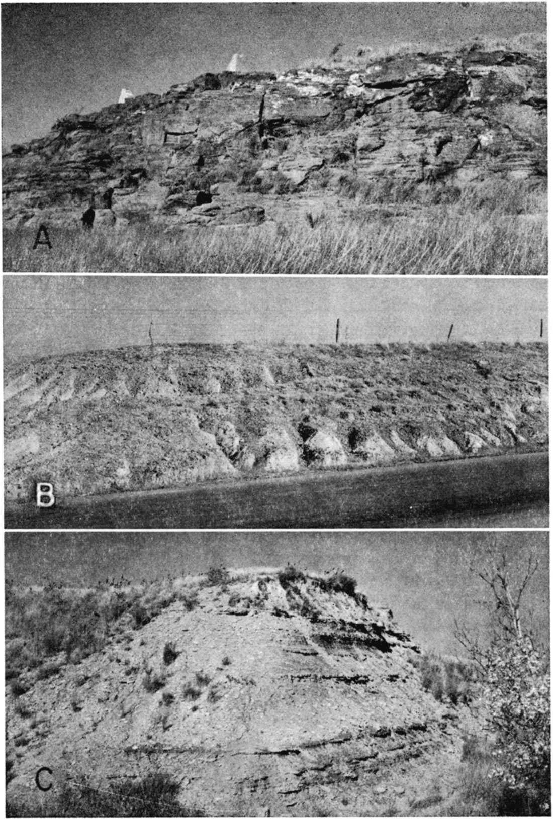
The Dakota formation is composed of alternating beds of varicolored clay, shale, siltstone, and sandstone, in which siderite, hematite, and limonite are abundant. Lignite and thin beds of brown "ironstone" are also commonly found in the formation (Pl. 8B). Pyrite, which is abundant in the underlying Kiowa shale, is much less common in the Dakota formation.
Clay is the dominant type of rock in the Dakota formation and is light to dark gray, white, tan, brown, yellow, and red. White, gray, yellow, tan, and brown fine- to coarse-grained sandstone occurs as thin beds in the clay and as lenses ranging from a few feet to more than 30 feet in thickness. There is no regularity in the occurrence of the thick sandstone lenses. They are discontinuous bodies that may be encountered in any part of the formation. Although clay is more abundant, the sandstones of the Dakota formation are more prominent in the areas of outcrop because of their greater resistance to erosion (Pl. 8A).
Plate 8—A, Sandstone of the Dakota formation above Pawnee Rock in the NE sec. 33, T. 20 S., R. 15 W., Barton County. B, Clay and thin beds of sandstone and "ironstone" of the Dakota formation. Road cut along U. S. Highway 281 in the SW sec. 21, T. 18 S., R. 13 W., Barton County. C, A part of the Graneros shale. South bluff of the Smoky Hill Valley in the NE sec. 19, T. 15 S., R. 15 W., Russell County, about 3 miles north of northwest comer of Barton County.
Plummer and Romary (1942) subdivide the Dakota formation into two members, the Janssen clay member above, and the Terra Cotta clay member below, and give complete descriptions of each. No attempt was made to differentiate these members in the Barton-Stafford County area.
The Dakota formation is 200 to 300 feet thick in the subsurface in the northern part of the area where the formation occurs in its full thickness. It is exposed along both sides of Blood Creek Valley, in the bluffs on the northern, northeastern, and southwestern sides of Cheyenne Bottoms, along the west side of Cow Creek west of Claflin, along the south side of Walnut Creek Valley, in three small areas north of Pawnee Rock, and in two small areas along the north bluff of Arkansas Valley between Great Bend and Dartmouth (Pl. 1). Only a small part of the total thickness is exposed at any one of these places. The formation is not exposed anywhere in Stafford County.
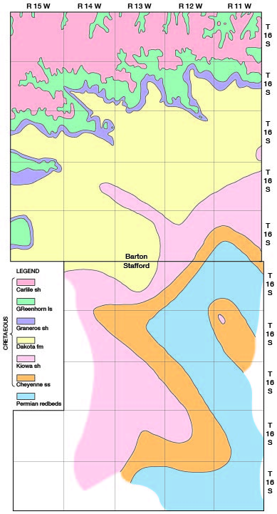
The Dakota formation lies conformably beneath the Graneros shale or unconformably beneath Quaternary silts, sands, and gravels in all but the southeastern part of Barton County, where it has been removed by erosion. Less than 50 feet of the Dakota unconformably underlies the Meade formation in extreme northwestern Stafford County. Elsewhere in that county it has been completely removed by erosion (Fig. 11).
Figure 11—Approximate distribution of the bedrock formations in Barton and Stafford Counties, Kansas.
The Dakota formation is the chief source of water in the upland areas of Barton County. The quantity of water available from this formation is quite variable and cannot be determined with certainty at any locality without test drilling. Wells that tap only the thin fine-grained sandstones have very small yields, whereas those that penetrate the thicker coarser-textured sandstone lenses have yields ranging from a few gallons a minute to a few hundred gallons a minute. About a third of the recorded wells in Barton County obtain water from the Dakota formation. Most of these are domestic and stock wells, but five (wells 18-11-4ad1, 18-11-4ad2, 19-11-31bb, 19-11-31bdc1, and 19-11-31bdc2) are city-supply wells and two (wells 16-13-8aa and 16-13-18aa) are industrial wells (Table 12). The Cities of Claflin and Ellinwood obtain their water supplies from wells penetrating thick sandstones of the Dakota formation.
The quality of the water from wells tapping the Dakota differs considerably; some wells yield water of good quality, whereas water from other wells is too highly mineralized to be suitable for ordinary uses. The analyses of 29 samples of water from the Dakota formation are given in Table 8. These samples contained 305 to 6,323 parts per million of dissolved solids, and their hardness ranged from 29 to 626 parts per million. Seven of the 29 samples contained more than 1,000 parts of chloride and many of them were high in fluoride and iron.
Graneros Shale
The Graneros shale consists of 30 to 40 feet of light- to dark-gray, blue-gray, and brown non-calcareous shale overlying the Dakota formation and overlain by the Greenhorn limestone. The shale contains selenite and pyrite and has thin yellow streaks of iron sulfate along bedding planes and joints. Thin beds of brown to dirty-white fine-grained sandstone occur in the formation in some areas and, locally, thin beds of hard, sandy fossiliferous limestone occur near the top of the formation. The Graneros shale is poorly exposed in the central, west-central, and southwestern parts of Barton County where it forms a gentle slope beneath the more resistant beds of the Greenhorn limestone. In most places in the outcrop area, exposures of the Graneros shale are obscured by soil. Better exposures of the formation are found in parts of Russell County (Pl. 8C). In Barton County the Graneros shale is found in the subsurface beneath the Greenhorn limestone, or beneath Quaternary sediments in narrow belts adjacent to the Greenhorn, but is not present anywhere in Stafford County (Fig. 11).
Where the Graneros shale is sandy, it probably would yield small supplies of water to wells; but in most places, because of the low permeability of the shale, it would yield little or no water to wells. None of the wells visited in Barton County yield water from this formation.
Greenhorn Limestone
The Greenhorn limestone underlies the surface or is found beneath the Carlile shale in the northern and western parts of Barton County (Pl. 1). It is 85 to 90 feet thick in this area and consists of alternating beds of hard chalk and chalky shale containing, in the lower part, thin beds of hard crystalline limestone. The individual chalk and limestone beds are generally less than a foot thick. On fresh exposures and in test-hole cuttings the chalks, limestones, and shales are light to dark gray and blue gray in color. Upon weathering, the color changes to tan, orange tan, or light gray.
Previous workers (Rubey and Bass, 1925, p. 45; and Bass, 1926, pp. 31-35) have subdivided the Greenhorn into four members, which from top to bottom are the Pfeifer shale, Jetmore chalk, Hartland shale, and Lincoln limestone.
The Pfeifer shale member comprises about the upper 20 feet of the Greenhorn limestone. It consists of chalky shale containing thin beds, 3 to 10 inches thick, of chalk and chalky limestone. At the top of the member is the Fencepost limestone—a bed of hard chalk about 9 inches thick that weathers yellow gray or cream and has a prominent iron-stained median line (Pl. 9A). It has been quarried for building stone, bridge masonry, and fence posts (Pl. 10C). Several layers of thin, flat concretions occur in the soft chalky shale underlying the Fencepost limestone bed (Pl. 9A).
Plate 9—A, Contact of the Fairport chalky shale member of the Carlile shale and the Pfeifer shale member of the Greenhorn limestone. Contact is at top of the Fencepost limestone bed in center of picture. Note the thin, flat concretions above and below the contact. In road cut along U. S. Highway 281 in the NW sec. 11, T. 16 S., R. 14 W., Barton County. B, Contact of the Jetmore chalk member and the Hartland shale member of the Greenhorn limestone. Contact is at top of dark-colored beds. Bluff of draw in the SW sec. 36, T. 15 S., R. 15 W., Russell County, about 0.2 mile west of northwest comer of Barton County.
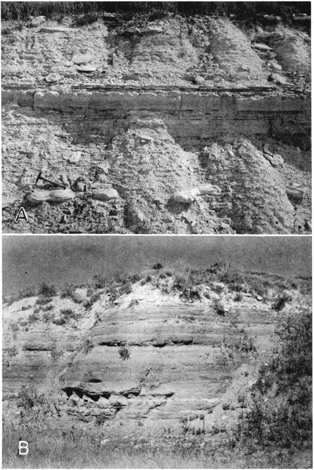
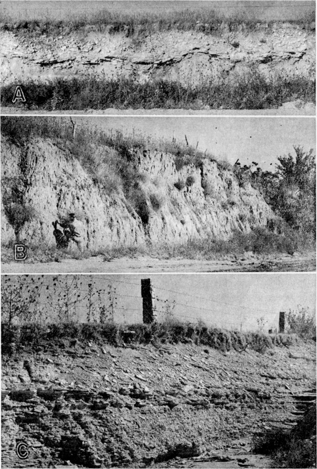
Plate 10—A, "Algal limestone" in road cut at center of east line sec. 20, T. 17 S., R. 13 W., Barton County. B, Silt of the Sanborn formation. Road cut along west line SW sec. 5, T. 18 S., R. 11 W., Barton County. C, A part of the Lincoln limestone member of Greenhorn limestone. Road cut at cen. W. line sec. 32, T. 17 S., R. 14 W., Barton County. The fence posts shown were quarried from the Fencepost limestone, the top bed of the Pfeifer shale member of the Greenhorn limestone.
The Jetmore chalk member, which underlies the Pfeifer shale member, consists of about 20 feet of alternating thin chalk beds and chalky shale. It is capped by a hard, fossiliferous bed of chalky limestone approximately 1 foot thick. Thin, flat chalky concretions occur in the shale immediately underlying this capping bed. The thin chalk beds of this member decrease in thickness downward, those in the lower part being about an inch in thickness. The chalky shale beds separating the chalk beds decrease in thickness from about 2 feet in the upper part to 2 inches near the base.
Below the Jetmore chalk member lies the Hartland shale member, consisting of 30 to 40 feet of chalky shale that contains a few thin beds of chalk and clay (Pl. 9B). The Lincoln limestone member, the basal member of the Greenhorn limestone, is about 20 feet thick and is composed of alternating beds of chalky shale and chalky limestone (Pl. 10C). Thin beds of hard crystalline limestone occur at the base and top of this member.
A few domestic and stock wells in the northern half of Barton County derive small supplies of water from the Greenhorn limestone. Most of these are shallow dug wells of large diameter that tap the near-surface weathered part of the formation, although some are deeper drilled wells. The yields of most of these wells are meager. Chemical analysis of a sample of water from well 16-14-2cb, which obtains water from the Greenhorn limestone, is given in Table 8. The water is hard but otherwise of good quality.
Carlile Shale
The Carlile shale, which conformably overlies the Greenhorn limestone, has been divided into three members by workers in other areas-the Codell sandstone member at the top, the Blue Hill shale member, and the Fairport chalky shale member at the base. Only a part of the lower, the Fairport chalky shale member, is present in the area under consideration.
The Fairport chalky shale member forms the surface of most of the upland area in northern Barton County (Pl. 1). In Russell County, where the full thickness of the member is present, it is 85 feet thick (Rubey and Bass, 1925, p. 40), but only the lower 50 feet or less remains in most of Barton County. Nearly the full thickness may be present in the vicinity of Galatia where it is covered by Tertiary sediments. The Fairport is lithologically similar to the underlying Greenhorn limestones and consists of chalky shale and thin beds of chalky limestone (Pl. 9A). Thin, flat concretions similar to those found near the top of the Greenhorn limestone occur in the lower part of the Fairport chalky shale member of the Carlile shale.
A few wells on the upland in northern Barton County obtain small to meager supplies of water from the Carlile shale for domestic and stock use. Records of seven such wells (16-11-24cc, 16-11-27cd, 16-12-12cb, 16-12-15ad, 16-14-26bb1, 16-15-28ca, and 17-15-18aa) are given in Table 12. All these are large-diameter dug wells less than 50 feet in depth. Samples of water from wells 16-11-27cd and 16-14-26bb1 contained, respectively, 673 and 2,277 parts per million of dissolved solids, 247 and 440 parts of chloride, and had hardness of 442 and 1,564 parts.
Tertiary System
Pliocene Series
Ogallala Formation
In the northern and western parts of Barton County a hard grayish-white arenaceous limestone marked with pinkish irregular concentric bands at the top is found capping small hills at widely scattered localities. At different places, it was found unconformably overlying the Dakota formation, Greenhorn limestone, and Carlile shale. In most places it is only a few inches thick and is broken into irregular blocks of different sizes. The greatest thickness noted was in a road cut 0.4 mile south of the NW cor. sec. 21, T. 17 S., R. 12 W., where it is somewhat more than 3 feet thick (Pl. 10A). The individual areas underlain by this limestone are only a few acres in extent, although at one time they probably had wider distribution. This limestone is believed to be equivalent to the "Algal limestone" or capping limestone of the Ogallala formation of other areas (Elias, 1931, pp. 136-141; Frye, 1945, pp. 89-91). It lies everywhere above the water table and does not yield water to wells in this area.
Prev Page—Geology, Pre-Permian and Permian || Next Page—Quaternary
Kansas Geological Survey, Barton and Stafford Geohydrology
Web version Dec. 2001. Original publication date Dec. 1950.
Comments to webadmin@kgs.ku.edu
The URL for this page is http://www.kgs.ku.edu/General/Geology/Barton/05_geol3.html