![]()
Prev Page--Introduction || Next Page--Mineral resources
Geology
[Note: The stratigraphic classification used in this report is that of the State Geological Survey of Kansas and does not necessarily follow the nomenclature of the U. S. Geological Survey.]
Subsurface Stratigraphy
Sedimentary rocks of Paleozoic and Cenozoic age underlie Allen County. The Paleozoic rocks are of Cambrian, Ordovician, Devonian, Mississippian, and Pennsylvanian age and overlie Precambrian igneous and metamorphic rocks. Paleozoic rocks in Allen County have an average thickness of about 2,000 feet (Jewett, 1954). The Cenozoic rocks are of Tertiary(?) and Quaternary age and have a maximum thickness of 35 feet. The general thickness and character of subsurface rocks are known from the study of well logs and samples of drill cuttings from oil and gas wells in the area.
Precambrian Rocks
Wells drilled to the Precambrian at two locations in Allen County are reported to have encountered schist and granite (Cole and others, 1961).
The Precambrian surface slopes to the west across Allen County from about 900 feet below sea level on the eastern edge to about 1,300 feet below sea level on the western edge (Cole, 1962).
Cambrian Rocks
In Allen County, Cambrian rocks are comprised of three formations: Lamotte (Reagan) Sandstone, Bonneterre Dolomite, and Eminence Dolomite. The Eminence Dolomite is the lowermost formation of the Cambrian and Ordovician Arbuckle Group. The total thickness of Cambrian rocks in Allen County is about 150 feet (Jewett, 1954).
Ordovician Rocks
Ordovician rocks in Allen County are composed of four formations which are, in ascending order, the Gasconade Dolomite, Roubidoux Formation, Jefferson City Dolomite, and Cotter Dolomite. These formations are the upper four formations of the Cambrian and Ordovician Arbuckle Group and have an average composite thickness in Allen County of about 590 feet (Jewett, 1954).
Devonian and Mississippian Rocks
Directly overlying rocks of the Arbuckle Group and underlying rocks of known Mississippian age is the Chattanooga Shale. This formation is believed to be less than 50 feet thick in all parts of Allen County (Jewett, 1954).
Mississippian Rocks
The thickness of Mississippian limestone formations in Allen County averages about 300 feet. The Chouteau Limestone and Sedalia Dolomite of Kinderhookian age, the Burlington Limestone of Osagian age, and the Warsaw Limestone of Meramecian age are believed to be present in the county (Lee, 1940).
Pennsylvanian Rocks
The thickness of Pennsylvanian formations in Allen County averages about 895 feet (Jewett, 1954). Pennsylvanian rocks in the county are of Desmoinesian, Missourian, and Virgilian age. The Desmoinesian Stage is composed of the Cherokee and Marmaton Groups. The Missourian Stage consists of the Pleasanton, Kansas City, and Lansing Groups. The Virgilian Stage is made up of the Douglas, Shawnee, and Wabaunsee Groups. Only rocks of the Missourian and Virgilian Stages are exposed in Allen County, and only these are described in more detail in the following section.
Stratigraphy of Outcropping Rocks
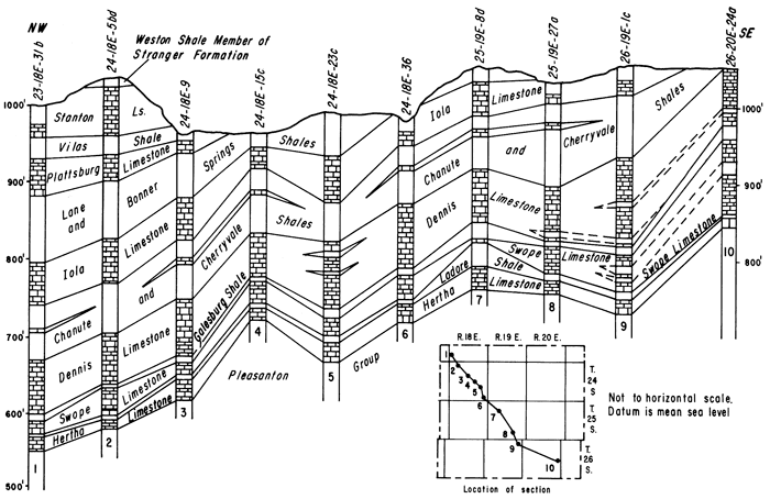
Correlation of units discussed in this report is based on measured sections, sample logs, and drillers' logs. Figure 3 is a stratigraphic section parallel to the regional dip that shows the relationship of the units discussed.
Figure 3--Generalized stratigraphic section parallel to the regional dip showing the relationship of the units discussed in this report.
Pennsylvanian System--Missourian Stage
Kansas City Group--Bronson Subgroup
Hertha Limestone
The Hertha Limestone (Adams and others, 1903) is comprised of three members which are, in ascending order, the Critzer Limestone, Mound City Shale, and Sniabar Limestone Members. Of the three members, only the Mound City and the Sniabar crop out in Allen County.
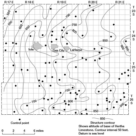
The Hertha is the oldest outcropping formation in Allen County and is very poorly exposed along the valley of the Marmaton River in the southeastern part of the county. It has an average exposed thickness of about 12 feet. Figure 4 is a structure contour map, based on drillers' logs, drawn on the base of the Hertha.
Figure 4--Configuration of the base of the Kansas City Group (Hertha Limestone). Control points arc from logs on file at the State Geological Survey of Kansas.
Mound City Shale Member--The Mound City Shale Member (Jewett, 1932) is seen at the NE NE sec. 10, T. 26 S., R. 21 E. It consists of 3 feet of yellowish-gray clayey shale. A thin (0.3 foot) dark-bluish-gray fossiliferous limestone occurs near the middle of the unit. In the subsurface, at the NE NE sec. 24, T. 26 S., R. 20 E., the upper 1 foot of the Mound City is black fissile shale.
Sniabar Limestone Member--The Sniabar Limestone Member (Jewett, 1932) is poorly exposed at the NE NE sec. 10, T. 26 S., R. 21 E., and is a bluish-gray to light-gray dense algal limestone. It is cherty with numerous shale partings. The Sniabar at this location is about 9 feet thick and is very fossiliferous. Individual fossil fragments are usually algal encrusted.
Ladore Shale
The Ladore Shale (Adams and others, 1904) is about 15 feet thick in an exposure east of the county line (NW SW sec. 12, T. 26 S., R. 21 E.) in Bourbon County. It is not well exposed in Allen County but is about 2 to 3 feet thick in well 26-20E-24aaa. Throughout much of the subsurface of Allen County the formation averages about 5 feet thick.
The Ladore Shale was not observed at the surface in Allen County owing to the poor exposures in this part of the stratigraphic section. In the subsurface the Ladore is composed of tannish-gray arenaceous shale.
Swope Limestone
The Swope Limestone (Newell, 1935) is comprised of two limestone members and one intercalated shale member. They are, in ascending order, the Middle Creek Limestone, Hushpuckney Shale, and Bethany Falls Limestone Members. The Swope is fairly well exposed along the streams in the southeastern corner and the northeastern corner of Allen County. It has no distinct topographic expression but is easily distinguished from units above and below because of the characteristic lithologies of its members. The Swope has an average thickness in Allen County of about 60 feet, with local thicknesses of 75 feet.
| Section of Swope Limestone in a streambed and road cut from the SE SE SE sec. 15 to the NE NE NE sec. 22, T. 26 S., R. 21 E. | Thickness, feet |
||
|---|---|---|---|
| Swope Limestone | |||
| Bethany Falls Limestone Member | |||
| Limestone, fine-grained, mottled dark-olive-gray and light-tannish-brown, unevenly bedded, unfossiliferous except for a few brachiopods and crinoid stems; contains some scattered chert | 15.3 | ||
| Limestone, fine-grained, brownish-gray | 1.0 | ||
| 16.3 | |||
| Hushpuckney Shale Member | |||
| Covered interval | 3.1 | ||
| Shale, black, hard, fissile, unfossiliferous | 1.9 | ||
| 5.0 | |||
| Middle Creek Limestone Member | |||
| Limestone, medium-dark-gray, hard, dense, brittle; contains some brachiopods | 3.0 | ||
| 3.0 | |||
Middle Creek Limestone Member--The Middle Creek Limestone Member (Newell, 1935) is a dark-gray to bluish-gray dense fine-grained limestone that is usually seen on the outcrop as a single massive unit. It is brittle and fractures with a hackly to conchoidal surface. Locally, it comprises three limestone beds separated by thin shale partings. The lower limestone averages 0.5 foot in thickness, the lower shale averages 0.35 foot, the middle limestone averages 0.5 foot, the upper shale averages 0.8 foot, and the upper limestone averages 1.3 feet. The Middle Creek has an average thickness of about 3.5 feet.
Hushpuckney Shale Member--The Hushpuckney Shale Member (Newell, 1935) has an average thickness in Allen County of about 5 feet. In the NE NE sec. 22, T. 26 S., R. 21 E., the lower 1.9 feet of the Hushpuckney is black, fissile, hard, and unfossiliferous. The upper 3.1 feet is yellowish-gray clayey calcareous shale with small gastropods in a zone located 2.0 feet from the top of the member. Other fossils in the upper 3.1 feet include chonetid and productid brachiopods.
Bethany Falls Limestone Member--The Bethany Falls Limestone Member (Broadhead, 1865) is a light-olive-gray and medium-gray dense fine-grained mottled limestone. This very distinctive lithology makes the Bethany Falls easily identifiable. The Bethany Falls ranges in thickness from about 40 feet in the southeastern corner of Allen County to about 65 feet in the subsurface over much of the county.
The upper part of the Bethany Falls is occasionally cherty and oolitic. Locally, where the unit is thickest, thin (0.5-1 foot) beds of black fissile shale occur at about 20 feet and at about 30 feet above the base of the member.
The fusulinid Triticites is found locally in the lower part of the member and the brachiopods Meekella, Derbyia, and Antiquatonia are numerous. The brachiopod Juresania is found locally.Galesburg Shale
The Galesburg Shale (Adams and others, 1903) ranges in thickness in Allen County from about 1 foot to almost 17 feet. Where the Galesburg is less than 6 feet thick, it is a yellowish-gray mottled slightly calcareous shale; where the thickness is greater, it is bluish gray and clayey in the lower part with yellowish-tan silty shale in the upper part. Locally, thin beds of coal and siltstone occur in the upper part.
Dennis Limestone
The Dennis Limestone (Adams and others, 1903) is well exposed in the southeastern and northeastern parts of the county. It has an average thickness of about 60 feet.
The Dennis Limestone is comprised of, in ascending order, the Canville Limestone, Stark Shale, and Winterset Limestone Members.
| Section from Winterset Limestone Member of Dennis Limestone down into Bethany Falls Limestone Member of Swope Limestone measured by J. M. Jewett in the SE SE SW sec. 33, T. 25 S., R. 21 E. | Thickness, feet |
||
|---|---|---|---|
| Dennis Limestone | |||
| Winterset Limestone Member | |||
| Limestone, ooltic, cross-bedded; contains some chert | 20.0± | ||
| Covered interval | 6-10.0 | ||
| Limestone, blue to brownish-gray, weathers rough | 5.0 | ||
| 31-35.0± | |||
| Stark Shale Member | |||
| Shale, gray to yellow | 1.6 | ||
| Shale, black, platy | 3.0± | ||
| 4.6± | |||
| Canville Limestone Member | |||
| Limestone, gray, dense, earthy, may be partly covered | 1.0 | ||
| Galesburg Shale | |||
| Covered interval | 2-3.0 | ||
| Swope Limestone | |||
| Bethany Falls Limestone Member | |||
| Limestone, oolitic | 5.0± | ||
| Limestone, brecciated, crumbly | 6.0± | ||
| 11.0± | |||
Canville Limestone Member--The Canville Limestone Member (Jewett, 1932) is similar in lithology to the Middle Creek Limestone Member of the Swope Limestone. The Canville is a bluish-gray dense fine-grained massive limestone, which fractures with a hackly or conchoidal surface. It ranges in thickness from about 2 feet to almost 6 feet.
Stark Shale Member--The Stark Shale Member (Jewett, 1932) is characteristically a black fissile very hard unfossiliferous shale in the lower 3 feet and a grayish-yellow clayey soft fossiliferous shale in the upper 1.5 feet. Locally, the upper lithology is absent and the entire interval is black and fissile.
The most common fossils in the upper part of the Stark are chonetid brachiopods. Inarticulate brachiopods are found locally in the lower part of the member.
Winterset Limestone Member--The Winterset Limestone Member (Tilton and Bain, 1897) is light-gray to yellowish-gray medium-bedded fine- to medium-grained limestone in the upper part and medium- to coarse-grained limestone in the lower part. Shale partings, coarsely crystalline calcite, and algae are common in the lower part, and chert and cross-bedded oolite are common in the upper part.
The Winterset Limestone Member is very fossiliferous in Allen County. Locally, as in the NW NW NE sec. 16, T. 26 S., R. 20 E., the Winterset contains belemnoids, gastropods, pelecypods, trilobites, bryozoans, brachiopods, fusulinids, crinoids, and algae. The abundance of fossils and the increased total limestone thicknesses in the Dennis and Swope Limestones may indicate that they constituted part of a marine bank in Allen County.
The average thickness of the Winterset in Allen County is about 53 feet.
Kansas City Group--Linn Subgroup
Cherryvale Shale
The Cherryvale Shale (Haworth and Bennett, 1908) includes three shale and two limestone members. They are, in ascending order, the Fontana Shale, Block Limestone, Wea Shale, Westerville Limestone, and Quivira Shale Members. The Cherryvale ranges in thickness from about 19 feet at the NW NW sec. 25, T. 26 S., R. 19 E., to about 80 feet in the subsurface in the northwestern corner of the county. The Cherryvale Shale and the overlying Drum Limestone and Chanute Shale have been mapped as one unit on plate 1.
| Composite section from Cherryvale Shale down into Winterset Limestone Member of Dennis Limestone in a stream bed and road cut in the SW SW NW sec. 28, T. 23 S., R. 21 E. | Thickness, feet |
||
|---|---|---|---|
| Cherryvale Shale | |||
| Sandstone, fine-grained, tan, medium-bedded; contains abundant limonite specks | 2.0 | ||
| Shale, olive-gray to dusky-yellow; contains abundant plant impressions | 21.2 | ||
| Shale, dark-gray, platy | 2.2 | ||
| Limestone, sandy, dark-gray to brownish-gray, nodular | 0.2 | ||
| Shale, clayey, dark-reddish-brown with olive-green spots; contains soft ironstone pebbles | 5.8 | ||
| Shale, mostly covered; sandstone layers interbedded with sandy shale | 39.4 | ||
| 70.8 | |||
| Dennis Limestone | |||
| Winterset Limestone Member | |||
| Limestone, fine- to medium-grained, light-gray to tannish-gray, thin- to medium- bedded; algal with Echinaria, Linoproductus; fusulinids near center, oolitic at top | 13.8 | ||
| Shale, dark-gray to black, fissile | 0.5 | ||
| Limestone, medium-grained, light-olive-gray, massive; contains calcite crystals, algae, Linoproductus, Echinaria, and bryozoans. Lower part covered | 3.8 | ||
| 18.1 | |||
Fontana Shale Member--The Fontana Shale Member (Newell, 1935) is yellowish-gray to light-gray sandy shale. Limonite specks are common in the upper part of the unit. The Fontana is sparsely fossiliferous, with chonetid brachiopods being most common.
The Fontana ranges in thickness from about 5 to about 45 feet, and the unit is thickest in the northern and northwestern parts of Allen County.
Block Limestone Member--The Block Limestone Member (Newell, 1935) is a yellowish-tan dense medium-grained algal limestone. Locally, the unit contains calcite crystals. The Block has an average thickness of about 2 feet and is usually a single thin nodular limestone bed.
Wea Shale Member--The Wea Shale Member (Newell, 1935) is poorly exposed in Allen County and is characteristically an olive-gray to dusky-yellow platy shale, but locally the lower 2 to 3 feet is dark-gray fissile shale. Plant impressions and carbonaceous smudges are common.
The Wea ranges in thickness from about 4 feet in the southern part to almost 24 feet in the northern part of the county.
Westerville Limestone Member--The Westerville Limestone Member (Bain, 1898) was studied at only one locality. In the NE NE sec. 25, T. 26 S., R. 19 E., the Westerville is composed of 1.2 feet of light-olive-gray to brownish-gray fine- to coarse-grained limestone. The unit is very fossiliferous and many of the fossils have fillings of dark-gray limestone.
The Westerville is absent in parts of Allen County, possibly as a result of nondeposition. The unit is probably lens shaped and thins out within short distances.
Quivira Shale Member--The Quivira Shale Member (Newell, 1935) is an olive-gray to dusky-yellow clayey shale with limonite stains where the underlying Westerville is present. Where the Westerville is absent, the unit is called the undifferentiated Wea and Quivira Members and is characteristically yellowish gray and sandy.
At the NE NE sec. 25, T. 26 S., R. 19 E., the Quivira Shale Member is 2.3 feet thick. The combined Wea and Quivira attains thicknesses of about 30 feet.
Drum Limestone
The Drum Limestone (Adams and others, 1903) consists of a single massive bed of olive-gray to yellowish-gray dense medium-grained limestone. The unit usually weathers light yellowish brown. It has an average thickness of about 3 feet in outcrops but is thicker in the subsurface of northwestern Allen County.
The most characteristic feature of the Drum is the abundant white crinoid segments scattered throughout the limestone.
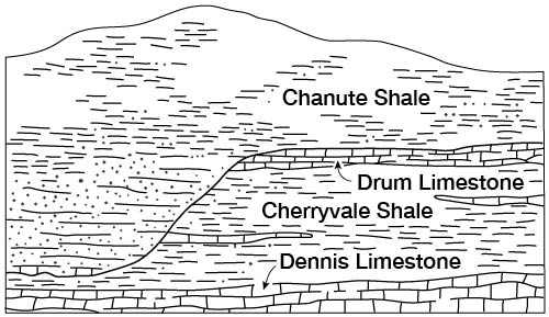
Post-Drum pre-Chanute erosion removed the Drum and, locally, much of the Cherryvale Shale from parts of northern and much of southern Allen County (fig. 5). Only one good outcrop of Drum was measured in the southern part of the county.
Figure 5--Effect of post-Drum Limestone channeling which occurred prior to deposition of the Chanute Shale.
| Section from Chanute Shale down into Winterset Limestone Member of Dennis Limestone in a creek bed and up a hill from the SE SE NW sec. 25 to the SE NE NE sec. 26, T. 26 S., R. 19 E. | Thickness, feet |
||
|---|---|---|---|
| Chanute Shale | |||
| Shale, arenaceous, dusky-yellow, mostly covered | 11.2 | ||
| 11.2 | |||
| Drum Limestone | |||
| Limestone, medium-grained, light-olive-gray, massive, dense; contains crinoids and brachiopod fragments | 2.6 | ||
| 2.6 | |||
| Cherryvale Shale | |||
| Quivira Shale Member | |||
| Shale, clayey, olive-gray and dusky-yellow, some limonite stains, sandier at top | 2.3 | ||
| Westerville Limestone Member | |||
| Limestone, fine- to coarse-grained, light-olive-gray to brownish-gray, blobs of dark silty fillings in fossils, very fossiliferous | 1.2 | ||
| Wea Shale Member | |||
| Shale, mostly covered | 4.6 | ||
| Block Limestone Member | |||
| Limestone, medium-grained, yellowish-tan, algal, dense; contains some fractured calcite crystals | 1.8 | ||
| Fontana Shale Member | |||
| Shale, mostly covered | 8.8 | ||
| 18.7 | |||
| Dennis Limestone | |||
| Winterset Limestone Member | |||
| Limestone, poorly exposed, fine- to medium-grained, light-olive -gray to yellowish-gray, medium-bedded, algal with large brachiopods and bryozoans; contains white chert at 11 feet from base. Lower part covered | 20.4± | ||
| 20.4± | |||
Chanute Shale
The Chanute Shale (Haworth and Bennett, 1908) varies greatly in thickness and lithology in Allen County. A definite range in thickness for the Chanute is difficult to determine owing to the channeling and filling previously mentioned. The thinnest section of Chanute Shale observed was at the SE SE sec. 33, T. 26 S., R. 18 E., where it is about 20 feet thick. The thickest section of Chanute Shale studied was along the east side of the NE sec. 2, T. 24 S., R. 20 E., where about 69 feet of olive- to bluish-gray sandy shale and dusky-yellow thin-bedded siltstone is exposed.
Where the underlying Drum Limestone is absent, the lower part of the Chanute is marked by a thick sequence of dusky-yellow thin- to medium-bedded fine-grained sandstone, which is locally cross bedded.
Plant remains and carbonaceous smudges are the most characteristic organic remains found in the Chanute Shale.
| Section from Muncie Creek Shale Member of Iola Limestone down into Drum Limestone measured by N. D. Newell in a road cut in the SE SE SE sec. 33, T. 26 S., R. 18 E. | Thickness, feet |
||
|---|---|---|---|
| Iola Limestone | |||
| Muncie Creek Shale Member | |||
| Shale, phosphatic concretions at base | 0.3 | ||
| Paola Limestone Member | |||
| Limestone, gray, blocky; contains cryptozoans and a few "worm borings" | 1.5 | ||
| 1.8 | |||
| Chanute Shale | |||
| Sandstone, brown, thick-bedded, ripple marks | 7.0 | ||
| Coal (Thayer coal) | 0.5 | ||
| Underclay | 1.0 | ||
| Shale, greenish-gray | 10.0 | ||
| Limestone, yellow, nodular, in limy shale | 2.0 | ||
| 20.5 | |||
| Drum Limestone | |||
| Limestone, coquinoid, molluscan | 2.0 | ||
| Limestone, fine-grained, gray and buff, nodular | 5.0± | ||
| 7.0± | |||
Iola Limestone
The Iola comprises two limestone members and one intercalated shale member. They are, in ascending order, the Paola Limestone, Muncie Creek Shale, and Raytown Limestone Members. The Iola has an extensive outcrop area and is the best-exposed unit in the county. It has an average thickness of about 40 feet. The unit apparently thins to the south and to the northeast from the vicinity of Iola in the west-central part of the county. About 110 square miles of Allen County is directly underlain by Iola Limestone.
The type section of the Iola Limestone (Haworth and Kirk, 1894) is at the south edge of Iola in the Lehigh Portland Cement Co. quarry.
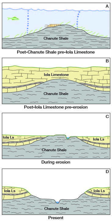
At several places along the outcrop of the Iola Limestone are inliers or "windows" through which Chanute Shale is exposed, as in secs. 9 and 16, T. 26 S., R. 18 E. (pl. 1). The Iola Limestone thins rather abruptly along the margins of these Chanute inliers. This type of inlier is rather common along the outcrop of the Iola and has been described by several geologists in other counties in eastern Kansas (Wagner, 1961; Jungmann, 1966). The Iola Limestone probably was deposited around topographic highs on the upper surface of the Chanute Shale (fig. 6).
Figure 6--Possible origin of Chanute Shale inliers in the Iola Limestone.
| Section from Plattsburg Limestone down into Paola Limestone Member of Iola Limestone measured by R. C. Moore at a quarry in the SW SE SE sec. 35, T. 24 S., R. 18 E. Type section of the Iola Limestone. | Thickness, feet |
||
|---|---|---|---|
| Lansing Group | |||
| Plattsburg Limestone | |||
| Limestone, weathers buff, in beds 0.1 to 1.0 foot thick separated by black shale, weathers shaly at top; contains poorly preserved bryozoans, brachiopods, and crinoid stems | 7.0 | ||
| 7.0 | |||
| Kansas City Group | |||
| Lane and Bonner Springs Shales | |||
| Shale, bluish-gray, uniform color, evenly bedded, silty, sandy in lower half; contains two or three 1-foot beds of hard, shaly micaceous sandstone | 49.0 | ||
| 49.0 | |||
| Iola Limestone | |||
| Raytown Limestone Member | |||
| Limestone, light-bluish-gray to nearly white, with top thin yellow crust and thick CaCO3 coating rock and fossils, thin- and evenly bedded, dense, beds 0.1 to 1.0 foot thick with parting of fossiliferous black shale, abundant crinoid stems and calyces | 6.0 | ||
| Limestone, light-gray, massive, fine- to medium-crystalline with very light buff cast, part appears irregular and brecciated with fine-grained fragments, in dark ground-mass, locally porous with fine calcite crystals lining the cavities. Some limestone is white and dense. Well-preserved brachiopods, bryozoans, but mostly unfossiliferous. Quarry floor is 3± feet above base of formation (this 3 feet includes Muncie Creek Shale Member and Paola Limestone Member) | 39.0± | ||
| 45.0± | |||
Paola Limestone Member--The Paola Limestone Member (Newell, 1935) is usually seen as a single massive bed of medium-gray to brownish-gray dense fine- to coarse-grained limestone. The top of the Paola has a wavy or hummocky surface and usually has "worm borings" extending from the top downward a few inches into the unit. The Paola has an average thickness of about 2.5 feet.
The Paola is usually algal and locally, as in the NE NE NE sec. 11, T. 25 S., R. 19 E., is very fossiliferous.
| Section from Raytown Limestone Member of Iola Limestone down into Chanute Shale measured by N. D. Newell in a creek bed and road exposure in the SW SW SW sec. 1, T. 26 S., R. 18 E. | Thickness, feet |
||
|---|---|---|---|
| Iola Limestone | |||
| Raytown Limestone Member | |||
| Limestone, whitish-gray, crystalline | 20.0± | ||
| Muncie Creek Shale Member | |||
| Shale, gray to yellowish-gray; phosphatic concretions at base | 0.3 | ||
| Paola Limestone Member | |||
| Limestone, fine-grained, bluish-gray, blocky; contains cryptozoans and a few "worm borings" at top | 2.0 | ||
| 22.3± | |||
| Chanute Shale | |||
| Shale, silty, gray, soft | 3.0 | ||
| Sandstone, platy | 15.0 | ||
| Coal (Thayer coal) | 0.3 | ||
| Underclay; lower part hard, limy | 2.0 | ||
| 20.3 | |||
Muncie Creek Shale Member--The Muncie Creek Shale Member (Newell, 1935) is a distinctive marker bed, which permits identification of the Iola Limestone even in badly weathered or partial exposures. It is an olive-gray to dusky-yellow clayey shale that contains spherical or ellipsoidal phosphatic nodules 1/4 to 1 inch in diameter wherever exposed. The surface of these nodules weathers white or light gray, and the interior remains black or dark gray. Most of the nodules have small fossil fragments at their centers. Locally, small (1/2 to 2 inches) doubly terminated gypsum crystals are found in the Muncie Creek. The gypsum could be the result of oxidation of pyrite or some other sulfide with subsequent release of sulfite. The sulfite combines with ground water to form sulfuric acid, which reacts with calcium from the shale or the adjacent limestone bed or with apatite [Ca5(PO4)3F] or collophane in the phosphatic nodules to form gypsum. Another explanation for the presence of the gypsum is that it could be primary; that is, formed at the time the shale was being deposited.
The Muncie Creek has an average thickness of about 0.5 foot.
Raytown Limestone Member--The Raytown Limestone Member (Hinds and Greene, 1915) is a light-gray to olive-gray medium-bedded fine- to coarse-grained limestone that weathers white to buff. Limonite is found locally as filling in vugs, and coarsely crystalline calcite is abundant. In a quarry exposure at the SE SW sec. 25, T. 24 S., R. 20 E., styolites are found in the upper 3 feet of the main ledge of the member. At several localities three thin limestone beds and two thin intercalated shale beds are 3 to 7 feet above the main ledge of the member. These thin limestone beds and intercalated shales have a thickness of about 3.6 feet, are separated from the lower main ledge by gray shale, and are a persistent part of the Raytown in much of eastern Kansas. The beds are identified in several well logs.
The main ledge of the Raytown Limestone Member contains a fossil assemblage that is characterized by rather large brachiopods (Linoproductus, Echinaria, and Neospirifer) and bryozoans. The upper limestone beds and intercalated shale beds are very fossiliferous and include crinoid columnals, plates, and calyces; small brachiopods; bryozoans; gastropods; horn corals; and trilobites. The bedding planes of the individual limestone beds are encrusted, and individual fossils are coated with a type of algae that gives the surface a sharp, hackly appearance.
The Raytown (including the upper limestones and shales) has an average thickness of about 37 feet.
Kansas City Group--Zarah Subgroup
Lane and Bonner Springs Shales
The Wyandotte Limestone, which usually separates the Lane Shale (Haworth and Kirk, 1895) from the Bonner Springs Shale (Newell, 1935) in areas north of Allen County, is present only along the northern county line in T. 23 S., R. 20 E. In this area, the Wyandotte is represented by a zone of thin-bedded flaggy micaceous and calcareous sandstones containing abundant marine fossils. The unit is not seen south of sec. 18, T. 24 S., R. 20 E., where an isolated outlier of calcareous sandstone about 1 foot thick may be seen.
The undifferentiated Lane and Bonner Springs Shales have an average thickness of about 59 feet. The unit is thicker in the northern part of the county, and thicknesses of 90 to 100 feet are not uncommon. The unit thins to the southwest, and at Humboldt it is about 30 feet thick. Where the unit attains its greatest thickness, it contains much dusky-yellow thin-bedded micaceous siltstone. The rest is characteristically light-olive-gray arenaceous to clayey shale. The siltstones in the unit contain plant impressions and carbonaceous smudges, and the shales are relatively unfossiliferous.
| Section from Spring Hill Limestone Member of Plattsburg Limestone down into undifferentiated Lane and Bonner Springs Shales in the NW NW sec. 2, T. 25 S., R. 18 E. | Thickness, feet |
|||
|---|---|---|---|---|
| Lansing Group | ||||
| Plattsburg Limestone | ||||
| Spring Hill Limestone Member | ||||
| Limestone, fine- to medium-grained, light-gray; contains shale parting, sponges, and brachlopods | 5.6 | |||
| Hickory Creek Shale Member | ||||
| Shale, brownish-gray, calcareous; contains dark-gray shale at base | 0.7 | |||
| Merriam Limestone Member | ||||
| Limestone, medium-grained, blocky-bedded, dense; contains small sponges, brachiopods, and Heterocoelia | 1.5 | |||
| 7.8 | ||||
| Kansas City Group | ||||
| Lane and Bonner Springs Shales | ||||
| Shale, arenaceous, bluish-gray, paper-thin bedding | 11.1 | |||
| Limestone, olive-gray, dense, nodular; contains some Myalina | 0.3 | |||
| Shale, arenaceous, bluish-gray | 38.0 | |||
| 49.4 | ||||
Lansing Group
Plattsburg Limestone
The Plattsburg Limestone (Broadhead, 1865) is the lowermost formation in the Lansing Group. It comprises two limestone members and one intercalated shale member. They are, in ascending order, the Merriam Limestone, Hickory Creek Shale, and Spring Hill Limestone Members. The Plattsburg ranges in thickness from about 15 feet in the western and southwestern parts to about 80 feet in the northern part of the county. It is usually a scarp-forming unit and has an extensive area of outcrop. Outliers or isolated patches of Plattsburg cap hills in many areas (pl. 1).
| Composite section from Stanton Limestone down into undifferentiated Lane and Bonner Springs Shales in the SW NW NW sec. 20, T. 24 S., R. 18 E. | Thickness, feet |
|||
|---|---|---|---|---|
| Lansing Group | ||||
| Stanton Limestone | ||||
| Limestone, fine- to coarse-grained, yellowish-tan to olive-tan, much crystalline calcite, badly weathered | 5.0± | |||
| 5.0± | ||||
| Vilas Shale | ||||
| Shale, olive-gray with reddish-gray zone about 30 feet from base, thin limestone stringers near base with abundant fossils; mostly covered | 52.8 | |||
| 52.8 | ||||
| Plattsburg Limestone | ||||
| Spring Hill Limestone Member | ||||
| Limestone, fine-grained, olive-gray; small pockets of shale, hematite concretions; algal with abundant fossil fragments | 2.8 | |||
| Shale, dark-reddish-brown, blocky; carbonaceous pebbles and limonite grains, almost conglomeratic | 0.2 | |||
| Limestone, fine-grained, olive-gray, weathers yellowish-tan; algal, streaks of carbonaceous material, small clay blebs | 6.0 | |||
| Limestone, shaly, soft, discontinuous | 0.2 | |||
| Limestone, fine-grained, medium-gray, dense; contains sparse brachiopods | 1.8 | |||
| Limestone, fine-grained, medium-gray, weathers light-gray mottled with dark-gray calcite stringers; contains crinoid stems in lower 0.9 foot | 6.7 | |||
| Hickory Creek Shale Member | ||||
| Shale, nodular, yellow, mostly covered | 2.5 | |||
| Merriam Limestone Member | ||||
| Limestone, bluish-gray, granular, blocky-bedded; poorly exposed | 2.2 | |||
| 22.4 | ||||
| Kansas City Group | ||||
| Lane and Bonner Springs Shales | ||||
| Shale, clayey, bluish-gray; mostly covered | 27.0± | |||
| 27.0± | ||||
Merriam Limestone Member--The Merriam Limestone Member (Newell, 1935) is easily recognizable owing to its lithology and stratigraphic position. It is usually seen on the outcrop as a single massive bed and is a gray to bluish-gray fine- to medium-grained limestone. Locally, the Merriam contains Heterocoelia and other small sponges in its fossil assemblage. Many of the fossil fragments are coated with Osagia. The unit has an average thickness of about 2 feet.
Hickory Creek Shale Member--The Hickory Creek Shale Member (Newell, 1935) is a yellowish-gray to brownish-gray calcareous shale that locally is dark gray in the lower part. Locally, as in the NW sec. 20, T. 24 S., R. 18 E., the Hickory Creek is dusky yellow and nodular. The Hickory Creek has an average thickness of about 0.5 foot. The unit is fossiliferous with crinoid stems and scattered spirifers being most abundant.
Spring Hill Limestone Member--The Spring Hill Limestone Member (Newell, 1935) is a light-olive-gray to medium-gray thin- to medium-bedded fine- to coarse-grained limestone. Calcite-filled veinlets and limonite blebs are common, and carbonaceous material is present in the upper part of the member in some outcrops. Dusky-yellow shale partings are common throughout the unit. The Spring Hill has an average thickness of about 20 feet.
The Spring Hill is fossiliferous, with the upper part containing a more varied fauna than the lower part. Enteletes, Triticites, and algae are the most abundant forms.
Vilas Shale
The Vilas Shale (Adams, 1898) is a yellowish-gray to light-gray clayey shale. In the NW sec. 20, T. 24 S., R. 18 E., the Vilas has a thin (1.0 foot) zone of maroon blocky clayey shale near the center. The unit thickens and becomes more arenaceous to the southwest. Large limestone concretions are found in the lower part of the unit in the southwestern part of the county. The Vilas has an average thickness of about 35 feet.
The Vilas Shale is relatively unfossiliferous. Crinoid stems and small brachiopods are found locally.
| Section from Stanton Limestone down into Plattsburg Limestone measured by N. D. Newell in a quarry in the NW SE SE sec. 27, T. 23 S., R. 18 E. | Thickness, feet |
|
|---|---|---|
| Stanton Limestone | 2 | |
| Vilas Shale | ||
| Shale, argillaceous; lower half maroon and purple; upper half buff; some large limestone concretions in lower part | 30 | |
| Plattsburg Limestone | 2 | |
| 34 | ||
Stanton Limestone
The Stanton Limestone (Haworth and Bennett, 1908) is the uppermost formation in the Lansing Group. It includes three limestone members and two intercalated shale members. They are, in ascending order, the Captain Creek Limestone, Eudora Shale, Stoner Limestone, Rock Lake Shale, and South Bend Limestone Members. Exposures of the upper two members were poor in Allen County but were excellent just across the county line in Woodson County. Descriptions of these upper two units are based on measured sections in Woodson County. The Stanton Limestone has an average thickness of about 47 feet.
| Section of Stanton Limestone in a quarry in the NE NE NE sec. 27, T. 23 S., R. 18 E. | Thickness, feet |
||
|---|---|---|---|
| Stanton Limestone | |||
| Stoner Limestone Member | |||
| Limestone, fine-grained, light-olive-gray thin- to medium-bedded, wavy | 9.0 | ||
| Limestone, coarse-grained, very pale brown, blocky, thick-bedded, sub-oolitic with algal encrustations | 7.8 | ||
| Limestone, coarse-grained, light-gray; contains abundant faunal remains; dark carbonaceous layers at bedding planes, filled with fossils, worm trails | 5.2 | ||
| Limestone, fine-grained, very light olive gray, blocky-bedded | 0.8 | ||
| Shale, light-gray | 0.3 | ||
| Limestone, dark-gray, fossiliferous; Enteletes and crinoid remains common | 0.2 | ||
| 23.3 | |||
| Eudora Shale Member | |||
| Shale, dark-olive-gray, very hard | 1.4 | ||
| Limestone, yellowish-gray, impure; contains numerous kinds of fossil fragments | 0.3 | ||
| Shale, dark-olive-gray, hard, blocky | 1.0 | ||
| 2.7 | |||
| Captain Creek Limestone Member | |||
| Limestone, fine-grained, light-brownish-gray with darker stringers of calcite, thin-bedded, dense, wavy; contains Neospirifer and Enteletes | 1.5 | ||
| Limestone, fine-grained, light-olive-gray, weathers white and powdery, massive, soft; contains small Hustedia and crinoid stems. Zone of medium-gray chert about 8 feet above quarry floor | 10.0 | ||
| 11.5 | |||
Captain Creek Limestone Member--The Captain Creek Limestone Member (Newell, 1935) is the best-exposed member of the Stanton Limestone. It is an olive-gray dense medium-bedded fine- to coarse-grained limestone. Locally, as in the NE sec. 27, T. 23 S., R. 18 E., most of the unit is seen as a single massive bed. The unit usually weathers to a buff color and locally weathers to a soft, powdery white outer rind. Chert and dark-gray calcite stringers are common in the upper part. The Captain Creek has an average thickness of about 11 feet in Allen County.
The lower part of the unit contains a biota in which Hustedia and crinoid stems are the most common forms. The upper part contains Neospirifer and Enteletes. Algae are common in the extreme upper part of the unit.
Eudora Shale Member--The Eudora Shale Member (Condra, 1930) is characteristically represented by a single bed of dark-olive-gray clay shale with isolated pockets or lenses of black fissile shale at the base. In a quarry at the NE cor. sec. 27, T. 23 S., R. 18 E., the Eudora is calcareous, indurated, and brittle and has a thin impure yellowish-gray limestone bed near the middle. The unit ranges from about 0.3 to 3 feet in thickness.
Scattered crinoid remains and the brachiopod Composita are the most abundant fossils found in the Eudora.
Stoner Limestone Member--The Stoner Limestone Member (Condra, 1927) is a light-gray to olive-gray thin-bedded fine-grained limestone that has numerous light-gray silty shale partings in the lower third. The middle third is very pale brown to light-olive-gray wavy- and thick-bedded coarse-grained limestone. The Stoner has an average thickness of about 25 feet.
The lower part of the member contains black carbonaceous clayey material rich in fossil remains on the bedding planes. "Worm trails" are also locally abundant on the bedding planes. The middle part contains Osagia-like algal encrustations. Enteletes, Composita, and Neospirifer are common throughout the member.
Rock Lale Shale Member--The Rock Lake Shale Member (Condra, 1927) is seen in only a few places in western Allen County. It consists of yellowish-orange and light-brown thin- to massive-bedded unfossiliferous fine-grained sandstone. The unit has a thickness of about 25 feet.
A few in miles to the west in Woodson County, the Rock Lake is a light-gray clay shale with a thickness of about 6 feet.
South Bend Limestone Member--The South Bend Limestone Member (Condra and Bengston, 1915) is poorly exposed in Allen County. In adjacent counties, however, the South Bend is composed of bluish-gray blocky thin-bedded coarse-grained crinoidal limestone with an average thickness of about 6 feet.
Pennsylvanian System--Virgilian Stage
Douglas Group
Stranger Formation
The Stranger Formation (Newell, 1935) is comprised of five members. They are, in ascending order, the Weston Shale, Iatan Limestone, Tonganoxie Sandstone, Westphalia Limestone, and Vinland Shale Members. The Weston is the only member of the Stranger Formation in Allen County.
Weston Shale Member--The Weston Shale Member (Keyes, 1899) underlies the upland surface in the northwestern part of the county but is poorly exposed. It is composed of light-olive-gray to bluish-gray clayey to sandy shale. The maximum thickness of the Weston in Allen County is probably about 30 feet.
Tertiary(?) and Quaternary Systems
Pre-Kansan and Kansan Deposits
Deposits of Pliocene(?) and Pleistocene age are found at altitudes 40 to 120 feet above the present flood plain of the Neosho River, scattered across upland surfaces and draped across valley walls. The gravels found at the highest levels are probably Pliocene in age, and the gravels found at the lower levels correspond in position to the Kansan age terrace described by O'Connor (1951) in the Cottonwood and Neosho River valleys. These lower deposits have a maximum thickness of about 8 feet. They are leached and oxidized, and consist mainly of chert pebbles in a dusky-yellow to reddish-yellow sandy clay matrix.
Quaternary System--Pleistocene Series
Illinoisan Stage
Deposits of gravel, sand, silt, and clay underlie a terrace 10 to 70 feet above the flood plain of the Neosho River (fig. 7). The Illinoisan terrace, owing to dissection, is not continuous. It slopes gently toward the river and merges with younger deposits, thus usually showing no definite topographic expression. Locally, as on the eastern side of geologic section D-D' and the western side of section E-E', noticeable bedrock "terraces" occur on the floor of the valley. These terraces are supported by resistant beds in the Raytown Limestone Member of the Iola Limestone and were formed by erosion.
Figure 7--Geologic sections across the Neosho River valley.
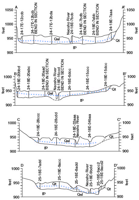
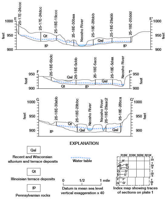
Pleistocene terrace deposits southwest of Iola and northwest of Humboldt on the west side of the Neosho River, which are believed to be of Illinoisan age, are higher in relation to the flood plain surface than elsewhere along the valley (fig. 7, E-E'). One possible explanation for this apparent anomaly may be that the upper 10 to 15 feet of the deposits is colluvial deposits of Recent age or that the terrace deposits may actually be older than Illinoisan. The Illinoisan deposits and colluvium have been mapped together on plate 1.
The Illinoisan deposits are composed of reddish-tan and yellowish-tan clayey silt in the upper part and brown chert pebbles in a yellowish-tan sandy clay matrix in the lower few feet.
The contacts between the Illinoisan deposits and the Wisconsinan and Recent deposits on figure 7 were placed principally by color changes in the deposits. The younger deposits are usually dark grays and browns, whereas the older (Illinoisan) deposits are lighter in color.
The maximum thickness of the Illinoisan deposits in Allen County is about 32 feet.
Wisconsinan and Recent Stages
Deposits of Wisconsinan and Recent age occur in the stream valleys of Allen County (pl. 1). In the Neosho River valley, Wisconsinan age deposits underlie one low terrace. The terrace is about 5 feet above the present flood plain. The surface of the Wisconsinan and Recent deposits is usually flat and undissected. Owing to the presence of manmade levies in most of the county, the occurrence of natural levies in these deposits is difficult to determine.
The deposits underlying the flood plain and the low terrace have similar lithology and are discussed and mapped as one unit in this report. They are composed of grayish-brown to dark-reddish-brown clayey silt, but are chiefly brown chert gravel and sand in the lower few feet. The average thickness of these deposits in Allen County is about 25 feet. The sand and gravel ranges in thickness from 0 to 12 feet and averages about 4 feet. Locally, as in the SW sec. 6, T. 24 S., R. 18 E., and the SE NE sec. 18, T. 25 S., R. 18 E., the deposits are predominantly sand and gravel or gravel.
Logs of selected test holes augered in the Neosho River valley are listed at the end of this report.
Structural Geology
A detailed discussion of the structural geology of Allen County is beyond the scope of this report. Regional and local structures have produced certain features, however, that are readily apparent in the exposed rocks. Some of these smaller structures, no doubt, have influenced the migration and accumulation of oil, and they are assumed also to have influenced groundwater movement and storage. Figure 4 is a structure contour map, based on drillers' logs, showing the configuration of the base of the Kansas City Group.
Regional Structure
The Chautauqua arch is a major pre-Mississippian structure that trends northwest across southeastern Kansas, and in Allen County the Chattanooga Shale and Mississippian limestones directly overlie the eroded upper surface of the Arbuckle Group (Jewett, 1951). The Chautauqua arch did not directly affect the attitude of the Mississippian and Pennsylvanian rocks, but it did result in a topographically high area trending across the county upon which younger rocks were deposited.
A low post-Mississippian structure known as the Bourbon arch trends westward across northern Allen County. This structure separates the Forest City basin to the north and the Cherokee basin to the south. The thickness of the Mississippian rocks increases away from the Bourbon arch, indicating erosion and thinning of Mississippian rocks on the arch before Pennsylvanian rocks were deposited (Jewett, 1951).
The Cherokee basin (Pryor basin) extends into southwestern Allen County and is an extension of the McAlester basin of Oklahoma (Jewett, 1951).
Another structural feature of eastern Kansas is the Prairie Plains monocline (Prosser and Beede, 1904). This post-Permian structure has produced a generally northwestward regional dip of the rocks in Allen County of about 12 to 15 feet per mile (Moore and Elledge, 1920). Merriam (1963) states that the northeastward-trending Longton ridge extends into southwestern Allen County and affects surface rocks, as does an unnamed structure (see fig. 4) trending northwestward across central Allen County into Coffey County.
Local Structures
In northern Allen County and in southern Anderson County just northeast of the town of Mildred is a small uplift called the Mildred dome (Charles, 1927). This structure has a surface closure of about 30 feet, and its axis is oriented about N. 65° W.
A northwestward-trend ing fault, which affects rocks from the Plattsburg Limestone through the Captain Creek Limestone Member of the Stanton Limestone, is located in the NE cor. sec. 19 and the SW NW sec. 20, T. 23 S., R. 19 E. (pl. 1).
Reversals of regional dip are shown in the outliers of Plattsburg Limestone scattered across north-central and west-central Allen County.
Many of the local structures probably are the result of regional factors. The area under discussion has been raised and depressed many times during geologic time, and the amount of movement probably has not been uniform over the county.
Some of the structural anomalies in Allen County may be reflections of the Precambrian surface. Differential compaction of sediments around Precambrian highs could produce minor structures that would he reflected in surface rocks. Many of the structures may have resulted from uneven distribution of the sediments at the time of deposition and before consolidation.
Prev Page--Introduction || Next Page--Mineral resources
Kansas Geological Survey, Geology
Placed on web April 14, 2009; originally published December 1969.
Comments to webadmin@kgs.ku.edu
The URL for this page is http://www.kgs.ku.edu/General/Geology/Allen/03_geol.html