![]()
Prev Page--Contents || Next Page--Geology
Introduction
Purpose of Investigation
This investigation of the geology and groundwater resources of Allen County was made to determine the thickness, lithology, distribution, and hydrologic properties of the rocks containing fresh water (less than 1,000 parts per million dissolved solids).
The study was begun in the summer of 1963 by the State Geological Survey of Kansas and the U.S. Geological Survey, in cooperation with the Division of Water Resources of the Kansas State Board of Agriculture and the Environmental Health Services of the Kansas State Department of Health.
Geography
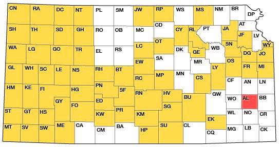
Allen County extends from long 95°05' W. to long 95°31' W. and from lat 37°44' N. to lat 38°02' N., and includes an area of about 504 square miles. The county is bounded on the north by Anderson County, on the west by Woodson County, on the south by Neosho County, and on the east by Bourbon County (fig. 1).
Figure 1--Index map of Kansas showing area described in this report and areas covered by other online geologic reports, as of April 2009. For additional information, please visit the KGS Geologic Maps of Kansas Page.
Allen County lies within the Osage Plains section of the Central Lowlands physiographic province as defined by Schoewe (1949). The major topographic features are the southward-trending Neosho River valley and the scarped upland plains that bevel the gently dipping sedimentary rocks underlying the county.
The Neosho River and its tributaries drain almost all the county, with the exception of the eastern one-quarter, which is drained by the Little Osage and Marmaton Rivers and their tributaries. The latter two streams flow in a generally easterly direction into Bourbon County. The Neosho River in Allen County has an average gradient of about 1.5 feet per mile (Kansas Water Resources Board, 1961).
Allen County has a subhumid climate characterized by moderate precipitation, mild winters, and hot summers. The annual precipitation at Iola, as compiled from records of the U.S. Weather Bureau, is summarized in table 1.
Table 1--Annual precipitation at Iola for the period 193 0-65 (from published records of the U.S. Weather Bureau).
| Year | Annual precipitation, in inches |
|---|---|
| 1930 | 38.09 |
| 1931 | 32.46 |
| 1932 | 27.82 |
| 1933 | 35.91 |
| 1934 | 34.59 |
| 1935 | 49.51 |
| 1936 | 22.31 |
| 1937 | 34.08 |
| 1938 | 37.32 |
| 1939 | 26.26 |
| 1940 | 35.18 |
| 1941 | 51.44 |
| 1942 | 43.45 |
| 1943 | 41.86 |
| 1944 | 48.98 |
| 1945 | 44.28 |
| 1946 | 29.60 |
| 1947 | 40.31 |
| 1948 | 43.14 |
| 1949 | 43.27 |
| 1950 | 34.22 |
| 1951 | 60.03 |
| 1952 | 24.34 |
| 1953 | 29.10 |
| 1954 | 27.48 |
| 1955 | 30.23 |
| 1956 | 28.20 |
| 1957 | 40.68 |
| 1958 | 42.71 |
| 1959 | 35.15 |
| 1960 | 35.62 |
| 1961 | 53.31 |
| 1962 | 34.99 |
| 1963 | 16.20 |
| 1964 | 33.49 |
| 1965 | 31.48 |
| Mean | 36.93 |
Allen County was organized in 1855 with a settlement of what now is Iola. In 1964, the population of Allen County was 17,109, of which about 68 percent was urban. [Note: Allen County population was listed as 14,385 in 2000 U.S. census, with a density of 28.6 (32.9 for the state) (KU Institute for Policy & Social Research).] Iola, the largest town and the county seat, had a population of 7,360 in 1964 [6,302 in 2000]. Other communities and their 1964 population are Humboldt, 2,484 [1,999 in 2000]; LaHarpe, 596 [706 in 2000]; Moran, 581 [562 in 2000]; Gas City, 395 [556 in 2000]; Elsmore, 129 [73 in 2000]; Savonburg, 123 [91 in 2000]; and Mildred, 58 [36 in 2000] (Kansas State Board of Agriculture, 1964).
Previous Investigations
The geology of Allen County and adjacent areas has been studied and described by many geologists. Principal workers and their subjects of investigation are listed in the Selected References section of this report.
Methods of Investigation
This report is based on geologic and hydrologic data collected and studied during 1963, 1964, and 1965.
The study of the geology included detailed examination and description of numerous stratigraphic sections as well as areal mapping (pl. 1). Geologic data in a report on the area by Moore and Elledge (1920) were restudied, and some of the data are incorporated in this report.
Supplementary information on the geology and ground-water hydrology of the county was obtained by an inventory of existing wells and by drilling test holes. The test holes were drilled with a truck-mounted power auger and a hydraulic-rotary drilling machine owned by the State Geological Survey. Samples collected in the course of drilling were later examined microscopically in the laboratory.
Areal geology was mapped on aerial photographs obtained from the U.S. Department of Agriculture, and then was transferred to a base map compiled from 7 1/2-minute topographic quadrangles of the U.S. Geological Survey.
Data on the chemical quality of water were obtained from analyses of water samples analyzed by the laboratory of the Environmental Health Services of the Kansas State Department of Health.
Well-Numbering System
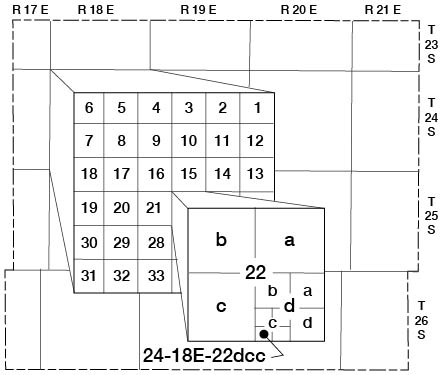
The locations of wells, test holes, and water-sampling points used in this report follow the scheme of General Land Office surveys. The well number is composed of township, range, and section numerals, followed by letters that indicate the subdivision of the section in which the well is located. The first letter denotes the quarter section (160-acre tract), the second letter denotes the quarter-quarter section (40-acre tract), and the third letter denotes the quarter-quarter-quarter section (10-acre tract). The 160-acre, 40-acre, and 10-acre tracts are designated a, b, C, and d in a counter-clockwise direction beginning in the northeast quadrant. For example, well 24-18E-22dcc is in the SW SW SE sec. 22, T. 24 S., R. 18 E. (fig. 2). If two or more wells are in the same 10-acre tract, they are numbered serially in the order in which they were inventoried.
Figure 2--Well-numbering system used in this report.
Acknowledgments
The author wishes to express his appreciation to the many residents of Allen County who supplied information concerning local geology, wells, and water supplies. Several drillers provided logs of wells that they had drilled in this area.
Mr. Virgil Burgat, Chief Geologist of the State Highway Commission of Kansas, provided geologic profiles of several highway projects in the county that were helpful in mapping and interpreting the geology. Mr. Carl Pate, Oilfield Research Laboratory, Chanute, Kans., provided many valuable analyses of water from oil- and gas-bearing rocks in the county.
Stratigraphic sections and other unpublished data on the geology and ground-water resources of the area collected by many other members of the U.S. and State Geological Surveys were utilized in the preparation of this report. This help is gratefully acknowledged.
Output from the IBM 7040 at The University of Kansas Computation Center, Richard G. Hetherington, Director, was used to facilitate the analysis of well and water-quality data.
Prev Page--Contents || Next Page--Geology
Kansas Geological Survey, Geology
Placed on web April 14, 2009; originally published December 1969.
Comments to webadmin@kgs.ku.edu
The URL for this page is http://www.kgs.ku.edu/General/Geology/Allen/02_intro.html