Kansas Geological Survey, Current Research in Earth Sciences, Bulletin 250, part 1
Prev Page--Petroleum Implications || Next Page--Petroleum Potential
![]()
![]()
![]()
Kansas Geological Survey, Current Research in Earth Sciences, Bulletin 250, part 1
Prev Page--Petroleum Implications ||
Next Page--Petroleum Potential
![]()
The Nemaha "Mountains" (Moore and Haynes, 1917; Moore, 1918) are a buried range of the Ancestral Rocky Mountains in eastern Kansas. The current elevation difference on the Precambrian surface between the remnant peaks and the valley below and to the east is over 3,300 ft in Nemaha County and over 2,300 ft in Wabaunsee and Pottawatomie counties (Cole, 1976). If there were travelers in eastern Kansas during the exposure of these mountains in the Pennsylvanian, the mountains would appear much as the present-day Front Range and Rocky Mountain peneplain do today to travelers to Colorado Springs and Denver. The subsurface topographic expression of this feature gradually decreases to the south, and there is little relief on the Precambrian/Paleozoic surface in Sumner and Cowley counties.
The eastern margin of the Nemaha is faulted (see for instance, Cole, 1976). The north portion of the eastern fault system in northeastern Kansas has been referred to as the Humboldt fault (Condra, 1927; Jewett, 1951), but segments of the fault system are traceable from north to south across the entire state. The system commonly has been portrayed as a series of normal faults (Kansas Geological Survey, 2000, for instance; Burchett et al., 1983). Merriam (1963) noted that the faults were likely both normal and reverse, but little note was taken of that description at that time.
It is the hypothesis of this paper that the Nemaha uplift is a reverse-faulted, perhaps thrust-faulted, structure, with the fault planes on the eastern margin dipping west. The consequence of this hypothesis is that petroleum-bearing reservoir rocks may underlie the thrusts (reverse faults) and may prove to be more productive than the reservoirs that have been discovered on the upthrown side of the faults. Further, there is the possibility that antithetic and back thrusting may occur on the western margins of the Nemaha and that these structures may also prove productive, if charged.
The Nemaha structure lies sub-parallel to the late Precambrian Midcontinent Rift System, a gravity anomaly that runs approximately 40 mi to the west of the Nemaha, and which contains at least 20,000 ft of detrital clastics, basic sills, and basalt flows. The geometry of the system and the fact that the Nemaha appears to have movements affecting sedimentation and erosion during the lower Paleozoic strongly suggest that the Nemaha has origin in the same tectonic regime as the original Midcontinent Rift System.
Lyons (1959) studied the gravity fields of the region, and designated a gravity anomaly he noted as the "Greenleaf Anomaly" for its maximum gravity anomaly of +15 milligals near Greenleaf in Washington County. He correlated it with gravity anomalies from Oklahoma's Anadarko basin to Lake Superior, a system now known as the Midcontinent Rift System, but theorized that this was an intracontinental "tectogene." In time context, plate tectonics was 10 years off, and geosynclinal theory could not explain features such as this. The observations and correlations of that time are valid today, but now fit into a unified theory of earth tectonics, plate tectonics, not yet known then. Overlapping sedimentary rock bodies and erosional truncation along the Nemaha argue for an active history throughout the lower Paleozoic (Lyons, 1959). The major tectonic movement forming the present-day Nemaha appears to be post-Mississippian and pre-Desmoinsian (Lyons, 1959; Jewett, 1951; Merriam, 1963), coincident with eastern seaboard tectonism and the coeval cratonic "Ancestral Rockies" deformation (see Burgess et al., 1997, for orientation of margin subduction).
Along its length, the Nemaha is broken by cross faults and apparent shears of northwest trend, some of which control the geometry of the Central Kansas uplift (Cole, 1976) (plate 1). Some of these cross faults have a vertical component resulting in knobs or monadnocks along the crestal trend. Further evidence that there is a vertical component to these cross faults is found in eastern Kansas along faults that trend northwest through Linn, Franklin, Shawnee, and Waubunsee counties (Merriam et al., 1958; Merriam, 1960; Merriam and Smith, 1961). Merriam (Merriam, personal communication, 2003) has seen up to 2,000 ft of either Precambrian or Cambrian sandstone in well samples on the north side of the fault, not present on the south side (Rogers and Slane #11 Paul Tholen. SE NW SW sec. 34, T. 23 S., R. 21 E., Allen County). The well previously was drilled to 4,505 ft; new projected TD is 6,500 ft). It is located only 18 mi from the Iola "Deep Well" that encountered 1,329 ft of sand and sandstone below the Arbuckle without reaching crystalline rocks (Haworth and Bennett, 1908). Merriam (personal communication, 2003) also stated that he has mapped up to 8 mi horizontal displacement along one of these faults, separating the Elmdale and Burns domes (interpreted from the map by Cole, 1976). Berendsen (1997) comments that the lateral component of motion is always greater than the vertical displacement along the cross faults, in both Missouri and in Kansas (p. 236).
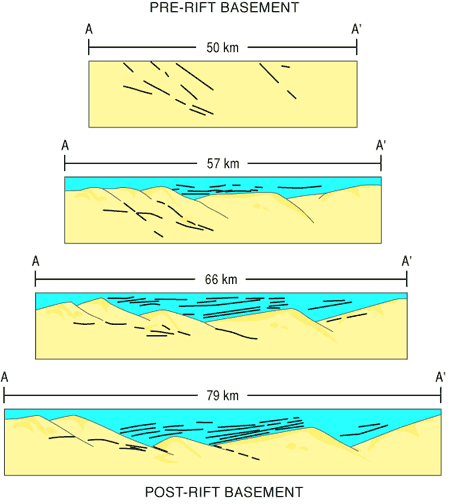
The importance of the cross faults to the tectonic history of the Nemaha is that these faults represent northwest-trending probable pre-Phanerozoic wrench fracturing of the Kansas crust, along directions that approximate many of the major structures of Kansas (especially those of the Central Kansas uplift and sub-structures contained therein), followed by crustal extension that formed the north-northeast-trending Midcontinent Rift System. The rift appears to have undergone repeated deformation (Serpa et al., 1989) (fig. 10).
Figure 10--Serial generalized cross sections from Serpa et al. (1989), showing geometric sequence of extensional events that resulted in the rift.
It is not possible to accurately date the rifting, as outlined previously. However, the rift fill has been in turn severely deformed, including by large-scale thrusting (Van Schmus, 1992; Woelk and Hinze, 1995), and lower Paleozoic rocks thin over the Nemaha. This suggests continued and persistent activity from the origin of the feature through to at least Desmoinesian time, when the present subsurface topography of the Nemaha was established. Minor reactivation continued through the present, accounting for drainage linearity. Cross fault right-lateral motion concurrent with or after uplift of the Nemaha is apparent at Elmdale and Burns domes, where Lansing Group rocks are downdropped 700 ft relative to the Elmdale dome, and apparently translated right lateral nearly 8 mi (Merriam et al., 1958; Merriam, 1960; Merriam and Smith, 1961).
For a quiet cratonic region, Kansas has had an active tectonic history.
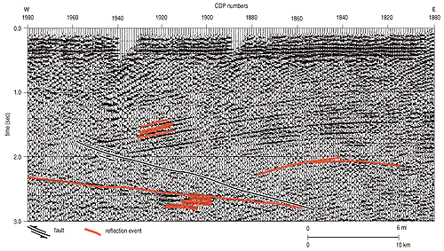
Thrusting in the rift (as earlier described) is of special interest here because the rift thrusts may be precursors to Paleozoic reverse faulting. Woelk and Hinze (1995) illustrate an interpretation of the rift in cross section that is thrust faulted on both sides (their fig. 9, reproduced here as fig. 11). The minimum displacement of the western fault (dipping east) is about 6 mi horizontally and 0.5 seconds vertically (two-way) (fig. 12). Using velocities of 5.5 km/sec for basalts, and 4.3 km/sec for well-indurated sandstones, and assuming that 50% of the section is each, the vertical displacement is about 1.23 km, or 1 mi. That implies that the dip of the thrust averages about 15%. We have previously discussed the possible origins of the thrusts, but the upthrust horst created by these faults almost specifies that the origin must be crustal shortening owing to the stress field changing from extension to compression. Figure 11 indicates that the west-dipping thrust may be ramped. Nothing in the data supports or denies interpretation that these thrusts are pre-existing faults that have been reactivated.
Figure 11--Diagrammatic cross section across the Midcontinent Rift System, showing thrust faults along the west and west sides of the rift. From Woelk and Hinze (1995). A larger version of this figure is available.

Figure 12--Detail of COCORP seismic section across the Midcontinent Rift System, showing western east-dipping thrust fault. Vertical displacement appears to be about 1 mi (1.6 km), and horizontal displacement is at least 6 mi (9.6 km). A larger version of this figure is available.
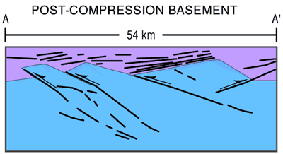
Reconstruction of the Midcontinent Rift based on the schematic cross sections of Serpa et al. (1989) (fig. 10) with crustal shortening added to the original rift extension and movement occurring along reactivated original normal faults demonstrates that the Nemaha is likely to be a reverse-faulted anticlinal structure. This is structural behavior similar to structures mapped in the Colorado Ancestral Rocky Mountains (Gerhard, 1967) (fig. 13). This diagram provides a model to test normal-fault models against reverse-fault models.
Figure 13--Post-compression model of Midcontinent Rift System showing possible resulting fault geometries. The reconstruction is based on the model of Serpa et al. (1989) (fig. 10), and uses the same failure planes.
The probability of reverse faulting is theoretically high. Bump (2003) has argued that the geometry of many Rocky Mountain Laramide structures may be related to shallow basement failure linked to reactivation of pre-existing fractures. Many of the surface expressions may be neotectonic elements resulting from reactivation, rather then direct reflections of the original structures.
The major deformation of the Nemaha took place in pre-Desmoinesian and post-Mississippian time (Lee, 1943; Merriam, 1963). If the entire vertical relief of the structure were visible at one time (as previously described), it would be an imposing structure. Merriam considers that it was more likely a range of lower-lying hills and ridges, inferring that sedimentation of debris eroded from the hills (mountains) filled the valleys as the range was elevated, subduing the topographic relief. Lee further describes a series of small movements along the fault system, starting in pre-Pennsylvanian time with truncated Mississippian rocks, and abrupt thickness changes in the Cherokee section of at least 900 ft (Lee, 1943, p. 124). It is likely that there was significant relief at various times along the Nemaha, but the full structural displacement may never have been topographically expressed at any one time.
Except for the Nemaha structure, the Precambrian/Phanerozoic surface of the Midcontinent Rift System is of generally low relief. There are several hills of a few hundred feet on that surface, in Marshall, Riley, and Marion counties (Cole, 1976), possible remnants of older topography. No rift features seem to have been sufficiently rejuvenated during the pre-Demoinesian tectonic episode so as to leave a topographic signature on the Precambrian/Phanerozoic surface, although there is a distinct valley corresponding to the major eastern border fault of the rift (Burchard fault of Carlson, 2001).
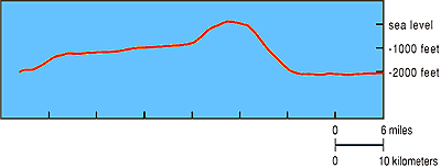
The shape of the Nemaha in cross section (along the boundary between R. 10 and 11 S.) shows the geometry of the block and its western complementary platform (fig. 14). Based on present topographic expression, the Nemaha is apparently scissored, hinging in northern or central Oklahoma, and having maximum displacement in northern Kansas and southeastern Nebraska, where Carlson (2001) shows it to terminate against successor structures to the Penokean Orogen.
Figure 14--Topographic profile of the Precambrian/Phanerozoic surface along a line between R. 10 and 11 S., in Geary and Waubunsee counties. Vertical exaggeration is 1:47. Line of section approximately 42 mi long. The unusual two-tiered configuration of the surface indicates that reverse faulting and "pop-up" of the Nemaha may be a rational solution to the model.
The sense of motion along the Humboldt and other eastern boundary faults of the Nemaha is at issue. As previously argued, many current maps show the fault system to be normal, that is, the hanging wall has moved downward with respect to the footwall. It is difficult to visualize the rest of Kansas being dropped down relative to the Nemaha. Several lines of inquiry suggest that the faulting is reversed, or possibly thrusted.
Numerous examples of reverse faults in Kansas are documented in the literature, most associated with the Midcontinent Rift and the Nemaha. Merriam (1963) noted that there were high-angle reverse faults and normal faults along the margin of the Nemaha. Earliest notation of reverse faulting in the literature is Bunte and Fortier (1941), who identified reverse faulting on the McPherson (Voshell) anticline, and Smith and Anders (1951), who documented reverse faulting on the east side of the Nemaha. More recently, reverse faults have been documented in a number of locations.
Roehl et al. (1989), interpreting a seismic line across the Lyons anticline in Rice County (at the eastern end of the Central Kansas uplift), suggest that the feature had a Keweenawan history as a broad symmetrical feature, a pre-Chattanooga movement, and a major late Mississippian or early Pennsylvanian deformation. That deformation resulted in the development of a reverse fault on the western side of the feature, dipping east, illustrated as a double reverse fault (their fig. 2). Haraldson et al. (1995), using the same seismic line, illustrate the reverse fault in more detail, with geologic supporting data. They also illustrate the Precambrian precursor structure.
Carr et al. (1995) document a reverse fault along the southwestern margin of the Central Kansas uplift in the Hampton field, with a vertical displacement of 100-150 m (328-492 ft). This fault is accompanied by an anticlinal fold on the upthrown block, in the theoretical position of a reverse-fault drag structure. The line of section is east-west, the dip is to the apparent south. Time of maximum displacement is pre-Arbuckle, which continues over the fault without interruption, although that horizon is folded. Carr et al. (1995) interpret that folding to be compaction-related rather than tectonic, although slight adjustments on the fault may not be discernible in the seismic data.
One county east Newell and Hatch (1999) have demonstrated oil accumulations to be the result of complex faulting along the north-south-trending McPherson anticline (including the Voshell field). They document both reverse and right-lateral movement along the main bounding fault, with a vertical throw of up to 400 ft (125 m). Individual pools are separated by cross faults that create closures. This demonstration of fault complexity is one of the few examples of lateral fault movement in Kansas. Strike-slip fault movements are likely frequent, but they are largely undetected because of the difficulty of geologically discerning such motion.
Newell (1996) also has studied the Paleozoic history of this system in detail. He found that there has been reversal of motion along the main fault, that is, down to the east, during early Paleozoic time, preserving younger portions of the Viola Formation and Silurian-Devonian "Hunton" beds. Newell also suggests that there is left-lateral motion along the Pratt anticline that is a relict of the Midcontinent Rift, and thus the Pratt structure may be a remnant portion of the western margins of that zone. Berendsen and Blair (1986) have argued that the Nemaha may be a sinistral (left-lateral) feature.
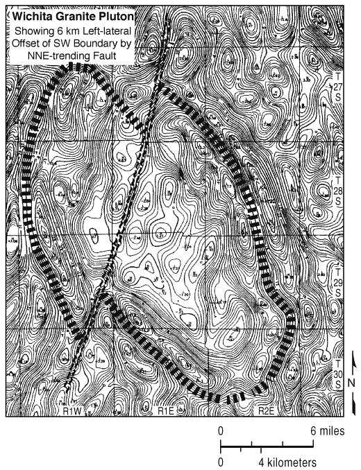
Gay (1995, 1999, 2003a, 2003b) has argued that the Nemaha is reverse faulted, providing both potential field interpretations of interacting terrane blocks (Gay, 1995) and numerous examples of reverse faulting derived from study of well logs (Gay, 1999) (fig. 15). He extended his study into Oklahoma, where the Nemaha structure is less apparent at the Precambrian/Phanerozoic surface. Gay considered that the Nemaha is a complex structure with thrust and strike-slip motion, although he gave no theoretical or regional context for that opinion, instead relying on the examples of reverse-fault motion from well logs, and from potential-fields study (fig. 15). His example of a 6-km (4-mi.) left-lateral offset in central eastern Kansas along the Nemaha is an important data set to establish the theoretical left-lateral motion (fig. 16), as has been the work of Berendsen and Blair (1986).
Figure 15--Location of known reverse faulting in Kansas along or associated with the Midcontinent Rift. Modified from Gay (1999).
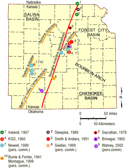
Figure 16--Interpreted left-lateral offset in the Wichita igneous complex, northern Sumner County, Kansas, demonstrating left-lateral wrench faulting along the southern portion of the Nemaha. Gay interpreted 4 mi (6 km) of offset to have occurred contemporaneously with the uplift of the Nemaha. From Gay (1999).
Gay makes several concluding points that are germane to this discussion. He argues, rightfully, that the tectonic origin of the Nemaha is in the Ancestral Rocky Mountain orogenesis, although he fails to relate that activity to the overall compressional regime of the Appalachian-Ouachita-Marathon deformation and the much earlier formation of the Midcontinent Rift System. Gay used many examples from the Rocky Mountain region to illustrate his viewpoint. Gay also has used the Kansas COCORP data to illustrate what may be thrust faults in the deep subsurface that could be "causative" faults for Nemaha reverse faulting. Gay also believes that the east-bounding fault is steeply dipping near the surface, but is a listric fault that dips much less steeply with depth. The present writer has had extensive research experience in the Ancestral Rockies and has previously had success in using the reverse-fault nature of Ancestral Rocky Mountain structures for finding petroleum accumulations.
Gay (1999) argues in his abstract that the Nemaha is a "pop-up" structure and that back thrusts are to be expected. The data supporting that statement are the presence of eastward-dipping thrusts along the McPherson anticline (Voshell anticline) in McPherson County so well documented by Newell and Hatch (1999).
Since completion of the first draft of this manuscript, Gay has published additional work arguing the the Nemaha tectonically reflects earlier Paleozoic eastern North America deformation and documenting additional compressional structures (Gay, 2003a, 2003b).
Prev Page--Petroleum Implications || Next Page--Petroleum Potential
Kansas Geological Survey
Web version Sept. 15, 2004
http://www.kgs.ku.edu/Current/2004/Gerhard/07_nemaha.html
email:webadmin@kgs.ku.edu