![]()
Prev Page--Introduction || Next Page--Recent Geologic History
Stratigraphy of outcropping rocks
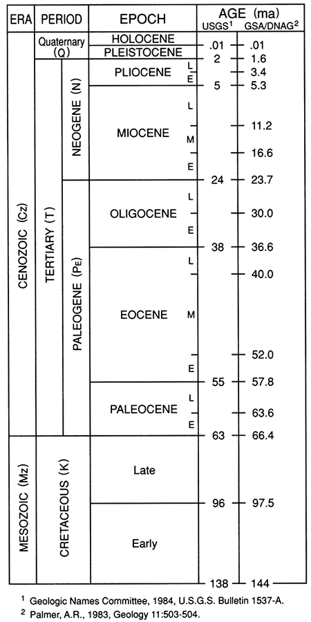
Rock units that crop out in Phillips County range in age from Upper Cretaceous to Holocene and include the Carlile Shale, the Niobrara Chalk, the Pierre Shale, the Ogallala Formation, and a complex assemblage of unconsolidated Quaternary eolian and fluvial deposits. Rock-stratigraphic and time-stratigraphic units relevant to this investigation are represented in fig. 3. Although not formally adopted by the Kansas Geological Survey, three notable changes have been made on the time-stratigraphic scale. The Ogallala Formation is presently known to be Miocene and perhaps earliest Pliocene. The Pleistocene Series reflects the classical four glacial advance model, which has been largely abandoned within the last two decades, hence the alternative time-stratigraphic designation of "pre-Illinoian stage" (informal use of stage). Also, "Holocene" has replaced "Recent," with a lower boundary change. Although no precise agreement exists regarding the temporal divisions between elements of the geologic time scale (Haq and van Eysinga, 1987), two of the chronologies most commonly used in the United States differ little (fig. 4). Divisions within the Pleistocene are detailed in a later section.
Figure 3--Classification of rocks in Phillips County. The chart has been modified from Zeller (1968) and reflects only that part of the column cropping out in the county.
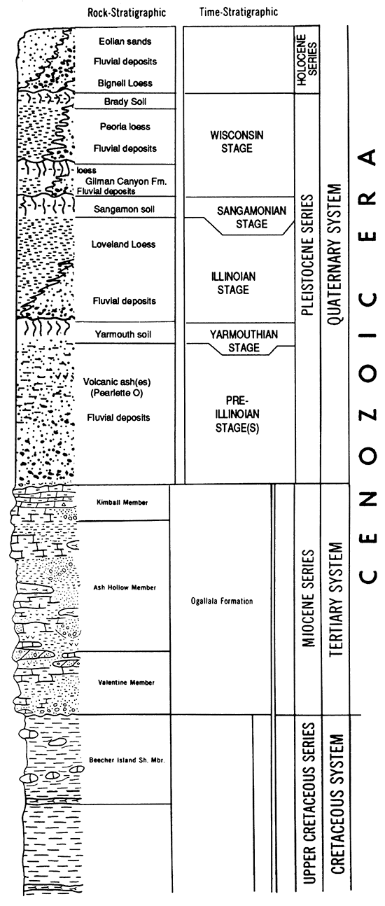
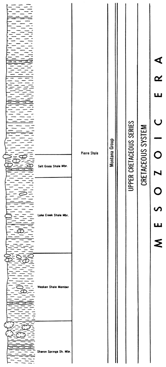
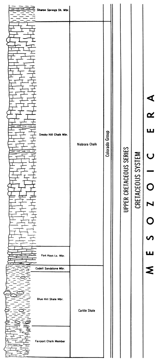
Figure 4--Geologic time scale. The scale does not extend beyond the Cretaceous, the limit for the surface geology of Phillips County.
Cretaceous System--Upper Cretaceous Series
Carlile Shale (Colorado Group)
Gilbert (1896) first named the Carlile Shale from exposures along the Arkansas River west of Pueblo, Colorado, at Carlile Station. Logan (1899) and Rubey and Bass (1925), among others, later modified and subdivided the Carlile Shale of Kansas. In Kansas the shale crops out in two general areas (Hattin, 1962). The larger of the two areas forms a belt that extends from Finney County in the southwest to Washington County in the northeast; a smaller area of Carlile Shale crops out in northwestern Hamilton County.
The Carlile Shale consists of about 300 ft (90 m) of argillaceous and chalky shale with bentonite, thick chalk beds, dark-gray fissile shale containing large septarian concretions, and fine-grained sandstone. Stratigraphically, the Carlile is situated between the top of the Fence-post limestone bed of the Greenhorn Limestone and the base of the Fort Hays Limestone Member of the Niobrara Chalk. The formation consists of three members: the Fairport Chalk Member, the Blue Hill Shale Member, and the Codell Sandstone Member.
The Fairport Chalk Member is a bluish-gray to gray chalky shale, chalky limestone, and calcareous shale that weathers to yellowish-gray and grayish-orange. Chalky limestone predominates near the base, and thin bentonite beds are found throughout the member. The thickness of the chalk within Kansas ranges from 85 ft to 147 ft (26-45 m). The Blue Hill Shale Member is a dark-gray clayey, blocky to fissile shale with a sand content that increases upward. Septarian concretions of calcium and clay-ironstone occur throughout. The thickness ranges from 70 ft to 200 ft (21-61 m) within Kansas. The Codell Sandstone Member is a fine-grained silty sandstone, locally shaly, that attains a thickness of no more than 25 ft (7.6 m) and thins to less than 1 ft (0.3 m). The Codell is not always a well-developed bed and can occur as thin lentils of sand.
The Carlile Shale underlies the entire county, but only one surface exposure has been located. A poor-quality exposure is found in NE NE sec. 34, T. 5 S., R. 17 W., within a small tributary to the North Fork Solomon River. This single exposure is a product of the north-south-trending Stockton anticline and the low topographic situation created by the river valley. At present, the exposure is badly slumped and overgrown by small trees and shrubs. However, in 1948 Byrne et al. measured, apparently next to a now abandoned road running up a small valley, 33.5 ft (10.2 m) of the Blue Hill Shale Member and 0.2 ft (0.06 m) of the Codell Sandstone Member. The Codell is also exposed directly beneath the Fort Hays Limestone Member in the upper valley wall, but no attempt was made to excavate a fresh exposure for remeasurement.
Because only the Blue Hill Shale and Codell Sandstone Members occur in a single outcrop, they were not differentiated on the county geologic map (W. C. Johnson and Arbogast, 1993; map designation Kc).
Niobrara Chalk (Colorado Group)
The Niobrara Chalk was named by Meek and Hayden in 1862 to characterize exposures of calcareous marl and chalky limestone in the Niobrara River valley of northeastern Nebraska. The formation was later subdivided into the Fort Hays Limestone Member and the Smoky Hill Chalk Member (Logan, 1897). Subsequently, other researchers [e.g., Bass (1926), Elias (1931), Moss (1932), Russell (1929), Cobban and Reeside (1952), and Hattin (1982)] have described and discussed the paleontology and stratigraphy of the Niobrara in western Kansas. The Niobrara is approximately 650 ft (200 m) thick in Phillips County (Landes and Keroher, 1942) and crops out progressively higher in the section from south to north. The Fort Hays Limestone Member forms the lower 45-50 ft (14-15 m) of the formation, and the Smoky Hill Chalk Member makes up the remainder. On the geologic map of the county CW. C. Johnson and Arbogast, 1993) the two members were differentiated and mapped as Knf and Kns, respectively.
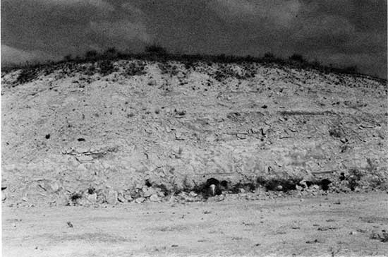
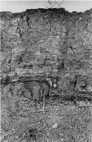
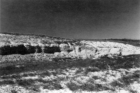
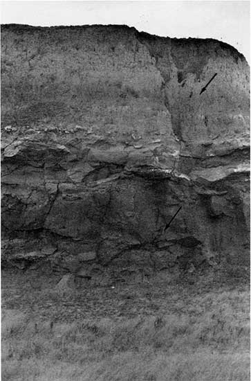
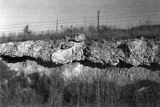
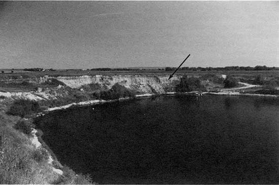
Fort Hays Limestone Member The Fort Hays Limestone Member, a marine limestone, lies conformably on the Carlile Shale. Outcrops of the Fort Hays are limited to the southeastern part of Phillips County. The two major areas of outcrop occur on the north and south sides of Bow Creek valley and the north side of the Solomon River valley near Kirwin Dam. Exposed thicknesses range up to 7.6 m (25 ft). The Fort Hays is considerably more erosion resistant than the Smoky Hill Chalk Member. As it occurs in the county, the Fort Hays is a buff chalky limestone exhibiting massive beds of chalk, up to 1.5 m (5 ft) thick, separated by thin shale partings. Upon weathering, the chalk beds become gray and limonite stained on the surface. The Fort Hays is well exposed in two small quarries within the southeastern part of Phillips County. One of these, presently in an early phase of excavation, is located at the base of the south valley wall of Bow Creek (NW NW NE sec. 25, T. 5 S., R. 17 W.). As of November 1989, 7.6 m (25 ft) of Fort Hays had been exposed. The second quarry, located about 8 km (5 mi) upstream on the north valley wall (SESW sec. 31, T. 5 S., R. 17 W.), provides a vertical face exposing 5.8 m (19 ft) of Fort Hays and 1.2-1.5 m (4-5 ft) of the overlying Smoky Hill Chalk Member (fig. 5). The contact is difficult to locate precisely because of the shaly nature of the upper Fort Hays and the weathered color and exposure of the Smoky Hill. A third exposure exists along the northeast shoreline of Kirwin Reservoir, extending approximately 2 m (7 ft) above the June 1989 pool level.
Figure 5--Exposure of the upper portion of the Fort Hays Limestone Member of the Niobrara Chalk in the Babcock Quarry. The quarry is located 0.8 km (0.13 mi) north of the Rooks County line in SE SW sec. 31, T. 5 S., R. 17 W. At present, the exposure is 7.16 m (23.5 ft) high, with the presumed Smoky Hill chalk contact at 5.7 m (19 ft) (arrow).
Smoky Hill Chalk Member The Smoky Hill Chalk Member has recently received intensive and extensive study by Hattin (1982). The type area in western Kansas consists of 12 sections that form a composite section over 596 ft (182 m) thick. In Kansas the outcrop of the Smoky Hill extends from north-central Finney County for 190 mi (306 km) northeastward to the Nebraska state line in northeastern Jewell County. The chalk is olive-gray, impure, well laminated to nonlaminated, and flaky in its weathering habit. Over 100 zones of bentonite have been recognized by Hattin; they range in thickness up to 0.37 ft (0.11 m) but are usually less than 0.1 ft (0.03 m) thick. They are most numerous in the lower portion of the member and weather to a rusty-gray, but the color of the member varies geographically. The basal part, cropping out in the southeastern corner of Phillips County, is blue-gray, and the middle portion of the member, exposed in the central part of the county, is predominantly tan or pink. A pink to orange color characterizes the upper part of the member, which crops out in the northern and western parts of the county. Vertebrate and invertebrate fossil material is common in the chalk, the most obvious fossils being a clam (Inoceramus grandis) and an oyster (Ostrea congesta).
At several outcrops within Phillips County where the chalk is directly overlain by the Ogallala Formation, the upper chalk beds have been silicified (Byrne et al., 1948, p. 6). The source of the silica was probably volcanic ash from the Ogallala Formation; percolating silica-rich waters presumably replaced the carbonate within some of the chalk beds. This silicified rock is brittle, produces conchoidal fractures, attains an 8-ft (2.4 m) maximum thickness, and frequently is green. In the past the silicified chalk has been quarried for use as fence posts and building stone (Landes and Keroher, 1942). The trace of an old WPA-era quarry still exists in NW sec. 23, T. 2 S., R. 17 W. These silicified zones are persistently near the eroded upper surface of the Smoky Hill Chalk Member and are locally cemented to overlying silicified deposits within the Ogallala.
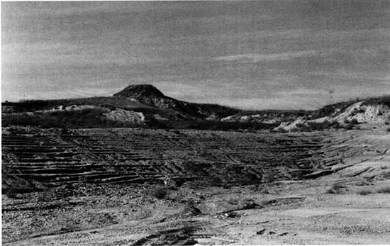
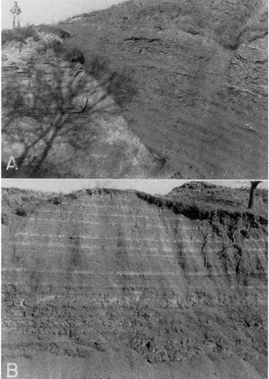
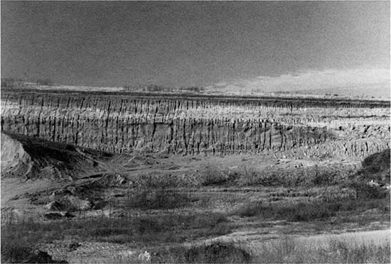
The Smoky Hill Chalk Member is exposed along stream valleys, except Prairie Dog Creek and its tributaries because of the regional northwest dip of the bedrock. Frequently, the chalk is eroded into a badland topography, an example of which is found in the area south of Glade. Chalk badlands would be more extensive in Phillips County if it were not for the overlying Ogallala Formation (fig. 6) or loess mantle (fig. 7). An example of these contrasting weathering characteristics is in and adjacent to a roadcut in S_ESE sec. 34, T. 3 S., R. 17 W., where the Smoky Hill crops out both with and without an Ogallala cover. A hill consisting of Smoky Hill chalk remains because of a cap of silicified chalk (secs. 17 and 18, T.4 S., R. 20 W.). The Smoky Hill is presently well exposed in a quarry 2 km (1.2 mi) northwest of Logan in SESW sec. 29, T. 4 S., R. 20 W. (fig. 8). Over 22 m (72 ft) of chalk are exposed beneath an erosional remnant of the Ogallala Formation, which persists because a silica-cemented sandstone lentil is present. A similar quarry exposure exists west of Speed.
Figure 6--Smoky Hill chalk-Ogallala contact (arrow) in a roadcut in SE SE sec. 34, T. 3 S, R. 17 W. Approximately 8.5 m (28 ft) of poorly cemented Ogallala overlie 8.9 m (29 ft) of chalk. The 10-cm-thick (4-in.-thick) chert bed at the top of the Smoky Hill Chalk Member is one of many in the member; these chert beds frequently occur at the top of the member because of their resistance to erosion. There is evidence that Paleo-Indians used this chert for the production of lithics (S. Holen, personal communication, 1990).
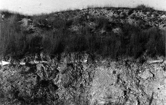
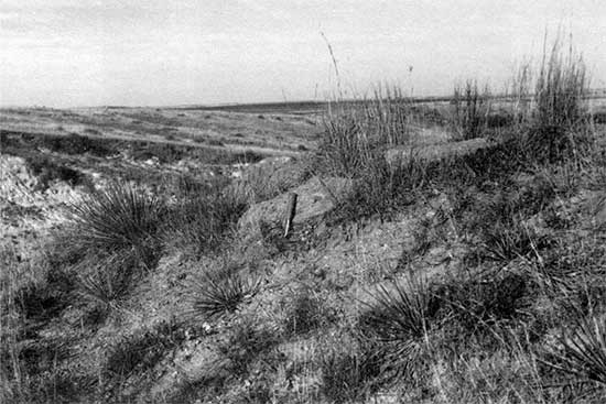
Figure 7--Loess-filled channels cut in the upper Smoky Hill Chalk Member exposed in a cut of the Missouri Pacific Railroad 0.5 km (0.3 mi) west of the Kirwin Wildlife Refuge entrance off K-9 (NW NW NE sec. 26, T. 4 S., R. 17 W.). Post-Sangamon pre-Gilman Canyon erosion is apparent from this dissection; that is, the freshly eroded surface of the chalk was buried sometime before 35,000 years ago.
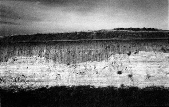
Figure 8--The Smoky Hill Chalk Member of the Niobrara Chalk with an overlying remnant of the Ogallala Formation in SE SW sec. 29, T. 4 S., R. 20 W. Because the chalk is on a structural high, the Ogallala is relatively thin here but has persisted because of an erosion-resistant silica-cemented sandstone lentil. The quarry exposes 72.2 ft (22.0 m) of the Smoky Hill Chalk Member; 1.52 m (5.0 ft) of the Ogallala cap the hill above the chalk.
Pierre Shale (Montana group)
In 1862 Meek and Hayden designated the Pierre Shale based on exposures at old Fort Pierre, South Dakota. Subsequently, Elias (1931) studied and described the Pierre Shale of Kansas. The shale is the youngest Cretaceous formation in Phillips County and the stratigraphically highest consolidated rock. Of the five members recognized within the Pierre Shale, only the lowermost Sharon Springs Shale Member is exposed in Phillips County. It is composed of black to dark gray-brown fissile, platy, noncalcareous shale with several thin zones of chalky shale and bentonite (Frye and A. R. Leonard, 1949). Thin veins and isolated crystals of gypsum (selenite) and small limonite concretions are found throughout the basal part of the member.
Based on available data, the probable thickness of the Pierre Shale in Phillips County is at most 50 ft (15 m). Frye and A. R. Leonard (1949) observed a maximum exposure thickness of 30 ft (9.1 m) and estimated a thickness of 46 ft (14 m) within a test hole. A thickness of 26.8 ft (8.17 m) was measured in this study along a roadcut on the south valley wall of Prairie Dog Creek in the western half of the western half of NW sec. 20, T. 1 S., R. 19 W. (fig. 9). Furthermore, no good exposures of the contact between the Niobrara Chalk and the Pierre Shale were documented. It is difficult to locate this contact because the Niobrara and the Pierre are similar in color and lithology. Consequently, the Pierre Shale was difficult to map, and where it is approximated, the mapping was done conservatively.
Figure 9--Pierre Shale exposed in a roadcut and surface in the western half of the western half of NW sec. 20, T. 1 S., R. 19 W. The shale forms the low ridge in the middle ground that extends into the Prairie Dog Creek bottoms. A total of 8.2 m (27 ft) of shale is exposed in the cut. The view is west from outcropping mortar beds of the Ogallala Formation.
Numerous thin beds of bentonite have been recognized across the northern portion of Phillips County (Kinney, 1942, p. 354). Only one active bentonite pit was located within the county; the Bohl Construction Company is extracting small quantities from a location approximately 1.5 km (0.9 mi) southeast of Long Island in SW NE SE sec. 25, T. 1 S., R. 20 W. (fig. 10).
Figure 10--A small fold exposed in a bentonite bed of the Pierre Shale 1 mi (0.6 km) southeast of Long Island in SW NE SE sec. 25, T. IS., R. 20 W. The bentonite is presently being excavated by the Bohl Construction Company.
Outcrops of the Pierre Shale occur only in the northwestern part of Phillips County along the south side of Prairie Dog Creek and are attributed to down warping in the Long Island syncline on the west side of the Stockton anticline (Landes and Keroher, 1942, p. 289). Mapping of the Pierre Shale has been difficult because of the lack of exposures and highly weathered nature of surface and near-surface material. Consequently, in many places the contact is approximate, and most mapping is done with the use of a hand-operated bucket auger. One notable structural feature is a normal fault where the Smoky Hill Chalk Member and the Pierre Shale are adjacent to one another; this faulting may be attributable to motion associated with development of the Long Island syncline. This exposure no longer exists because of slumping and overgrowth, but it was documented stratigraphically and photographically by Frye and A. R. Leonard (1949, p. 31). Two of their photographs are reproduced in fig. 11.
Figure 11--Pierre Shale exposed in the right (east) bank of Prairie Dog Creek in SE SE sec. 24, T. 1 S., R. 20 W. (A) Smoky Hill Chalk Member faulted against the Pierre Shale; (B) Pierre Shale exposed adjacent to the fault. The photographs are reproduced from Frye and A. R. Leonard (1949, pl. 5, p. 31). Slumping and a dense growth of trees and shrubs presently obscure the view depicted in the photographs.
Because the Sharon Springs is the only member of the Pierre Shale occurring in Phillips County, it has been indicated on the map with the letters Kps (W. C. Johnson and Arbogast, 1993).
Tertiary System--Miocene Series
Ogallala Formation
The Ogallala Formation is a heterogeneous massive to cross bedded complex of fluvial deposits laid down by streams flowing from the Rocky Mountain region during the Miocene and early Pliocene. It is the principal geologic formation in the High Plains and serves as the region's major aquifer. Outcrops are limited to the margin of the High Plains where erosion is occurring, such as along the contact with the Smoky Hills in Phillips County. A major discontinuity separates the Ogallala from the overlying Pliocene and Pleistocene deposits; significant thicknesses of the Ogallala were differentially removed during Pliocene and early Pleistocene erosion (Stanley and Wayne, 1972).
The name Ogallala was first proposed by Darton in 1899 based on work at a locality in southwestern Nebraska, although Darton did not actually designate a general type locality (Ogallala Station) until 1920 in a report on the geology of parts of Hamilton and Kearney counties in southwestern Kansas (Darton, 1920). Elias (1931, 1932, 1935, 1942) conducted detailed studies of the Ogallala in western Kansas and defined a precise type locality. Subsequently, the Nebraska Geological Survey classified the Ogallala as a group and subdivided it into four formations.
Darton (1899) believed that the Ogallala was late Tertiary, and Elias (1931), working in Wallace County, thought that the mammalian faunal content indicated a late Miocene to early Pliocene age. Boellstorff (1976) dated volcanic glass shards (fission-track dating) from the Ogallala type section, obtaining a late Miocene age of 7.6 ± 0.7 Ma. In Nebraska initiation of Ogallala time appears to coincide with that of the medial Barstovian land mammal age at about 14 Ma (Voorhies, 1990). The Clarendonian land mammal age of the Ogallala extends from 11.7 to about 9 Ma (Tedford et al., 1987), and the Hemphillian land mammal age of the formation covers the period of approximately 9 to 4.5 Ma (Berggren and Van Couvering, 1974). Fission-track ages compiled by Voorhies (1990) for the Ogallala range from 13.6 ± l.3 to 5.0 ± 0.2 Ma. Therefore a medial age of 9.5 m.y. (14-4.5 Ma) appears reasonable for the Ogallala in the region.
The Ogallala is capped locally by a hard pisolitic limestone or by a dense caliche layer, which is apparently isochronous, that is, a unique time-stratigraphic unit. The base of the Ogallala is, however, variable in age from one location to another because alluviation of the eastward-trending valleys cut in Cretaceous bedrock began in the lowest areas and continued as increasingly younger deposits transgressed the valley sides and flanking uplands.
Considerable paleoenvironmental information has been derived from fossil floral and faunal material in the Ogallala. Botanical information has come primarily from Elias (e.g., 1942) and Thomasson (e.g., 1979, 1987, 1990). Paleoflora from five localities in Texas, Kansas, and Nebraska indicate that the prevailing plant community was a grassland with scattered trees, perhaps in relatively dense but widely distributed stands (Thomasson, 1990). The coexistence of grazers such as horses and rhinos (Zakrzewski, 1988) supports the notion of expansive grasslands. One of five local faunas in north-central Kansas is located near the village of Gretna in eastern Phillips County (Zakrzewski, 1990). Three diagnostic mammalian taxa of the 22 present suggest that the site dates to about 12 Ma.
Three members The Kansas Geological Survey recognizes three members within the Ogallala Formation (Bayne and O'Connor, 1968). Faunal and floral remains, volcanic ash petrology, and gross lithology have been used to differentiate the members and to correlate them with the type sections in Nebraska. The Valentine member was the first to be deposited and is consequently restricted to Cretaceous bedrock Valleys. The member is characterized by medium to fine sands and some gravels, is greenish-gray to pink and pale tan, has layers of volcanic ash and bentonite, silica-cemented sand and gravel, and diatomaceous marl, and has a diagnostic fossil grass seed, Stipidium commune. Because the member is situated lowermost in bedrock valleys, it is rarely exposed. It is, however, well exposed in eastern Norton County at the Almena site (Frye and A. R. Leonard, 1949).
The Ash Hollow member was deposited on the Valentine and is therefore not associated exclusively with the bedrock valleys; it laps onto valley side slopes and frequently divides, resulting in relatively large-scale coverage of the landscape. It is lithologically heterogeneous (less local bedrock input) and generally coarser in texture than the underlying Valentine, gray to pink, characterized by rich floral zones (e.g., Krynitzkia coroniformis seed zone) and molluskan assemblages, rich in volcanic ash (particularly in the lower half), locally silica cemented to form erosion-resistant lentils of sandstone, and weakly cemented with carbonate at many levels to form the conspicuous mortar beds used as a source of lime during the early settlement period.
The uppermost member, the Kimball, was deposited after the filling of the bedrock valleys and is therefore expressed as a thin, unconfined apron of sediments mantling the landscape. Although coarse gravels occur locally at the base (Sidney gravels of Nebraska), the sediments are highly calcareous and predominantly gray fine to medium sand, silt, and clay. A dense pink to white pisolitic nodular caliche (calcrete), 3 ft (0.9 m) or less in thickness, caps the member. Because of the discovery of an alga, Chloreliopsis bradleyi, that required a perennial body of water, Elias (1931) believed that the pisolitic layer was an algal limestone originating from a terminal Ogallala lacustrine environment. Darton (1899) originally thought that the Kimball was a secondary deposit, and subsequent studies by Frye et al. (1956) and Swineford et al. (1958) demonstrated that the layer is primarily a product of pedogenesis. The member, easily differentiated by its distinctive basal plant fossils and fossil molluskan assemblages, has observed thicknesses ranging from 2.5 ft to 44 ft (0.76-13 m). However, only isolated erosional remnants of the Kimball member persist.
The three members of the Ogallala Formation are apparently not continuous throughout the unit's distribution. Gustavson and Winkler (1988) report that the Ogallala of Texas and eastern New Mexico is composed of alluvial sediments partially filling paleovalleys and extensive, thick eolian sediments mantling paleo-uplands and most alluvial sediments.
Three major areas of outcrop for the Ogallala can be defined in Phillips County. The thickest and most extensive outcrops occur along and adjacent to the east-west-trending divide across the northern part of the county, that is, in Tps. 1 and 2 S. In particular, extensive exposures and benches created by the mortar beds occur in this area (figs. 12 and 13), as do the silica-cemented sandstones discussed later. A second major outcrop area is in the south-central and southwestern parts of Phillips County along the flanks of the upland between the North Fork Solomon River to the north and Bow Creek to the south. Mortar beds are present here as well, but the lentils of silica-cemented sandstone are better expressed than elsewhere in the county--or the state. The third area of outcrop is the western portion of another wedgeshaped upland, or divide, in this case separating Deer Creek on the north from the North Fork Solomon River to the south. Where it outcrops, the Ogallala does so on the upper convex slope, or the shoulder, of the divides because loess mantles the crests of the divides and the lower toe slope is Cretaceous bedrock.
Figure 12--Small valley cut into the Ogallala Formation, exposing a mortar bed that produces a prominent bench. The view, from a mortar bed outcrop, is southwest from the extreme northwest corner of sec. 11, T. 2 S., R. 20 W. This is an unnamed tributary of Prairie Dog Creek to the north.
Figure 13--Outcrop of a mortar bed in the Ash Hollow member of the Ogallala Formation located in NW NW sec. 15, T. 2 S., R. 20 W. This abandoned quarry is located about 1 mi (0.6 km) southwest of the view in fig. 12 and is traceable as the same bed.
The thickness of the Ogallala varies greatly in Phillips County because of differences in the predepositional bedrock topography and the postdepositional denudation and dissection of the surface. The greatest thicknesses exist on the western side of the county. The thickest vertical section of the Ogallala (Ash Hollow member?) in the county occurs in a gravel pit, 3 km (1.9 mi) northeast of Prairie View in the eastern half of NE sec. 26, T. 2 S., R. 20 W. (fig. 14). Byrne et al. (1948, p. 8) report a maximum thickness of 150 ft (45.7 m) near the Norton County line. The overall trend is one of decreasing thickness to the east and south, a function of both preexisting Cretaceous bedrock topography and Pleistocene drainage development.
Figure 14--Quarry exposure of the presumed Ash Hollow member of the Ogallala Formation in the eastern half of NE sec. 26, T. 2 S., R. 20 W. The 10.7-m-high (35-ft-high) face (west) exhibits appreciable variation in stratigraphy horizontally and vertically and overall is pink to buff. This is currently one of the highest vertical exposures of the Ogallala in the county.
Because of a paucity of continuously traceable stratigraphic units within the Ogallala, the three members could not be differentiated, and the formation is designated To on the county geologic map (W. C. Johnson and Arbogast, 1993).
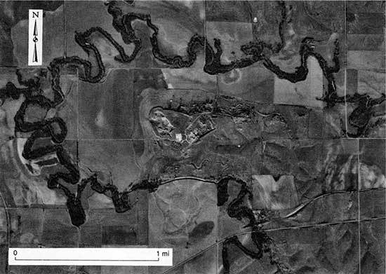
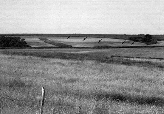
Silica-cemented sandstone Prominent lenticular bodies of silica-cemented sandstone occur within the Ogallala Formation of Phillips County. The term "quartzite" has been applied [e.g., Bates and Jackson (1987, p. 543)] to these deposits, but it is not used here to avoid confusion with the more common metamorphic definition of quartzite. The resistance of the lenses to erosion is obvious in their topographic expression. As caprock, they have formed small buttes, pinnacles, and benches, such as those south of Glade. Furthermore, the beds have influenced the drainage patterns of at least two major streams in Phillips County (Frye and Swineford, 1946). In the northwestern section just west of Woodruff, northeastward-flowing Prairie Dog Creek assumes an anomalous course back to the west and north around an elongate hill capped by lentils of the sandstone (fig. 15). Upland gravels indicate that, during the late middle Pleistocene, before the present level of entrenchment, the creek was flowing northeastward without this deviation. Similarly, Bow Creek, which flows along the southern boundary of Phillips County, has a channel-bed elevation that is higher than adjacent and parallel major drainages. The gradient steepens abruptly to the west of the sandstone lentils, suggesting that the lentils slowed the rate of downcutting and tributary development.
Figure 15--The anomalous westward deflection of northeastward-flowing Prairie Dog Creek around a ridge capped by a silica-cemented sandstone bed in the Ogallala Formation. The quarries from which the silica-cemented sandstone has been extracted are apparent on the west end of the ridge. The railroad cut in the lower right sector exposes sand and gravel of Illinoian age overlain by the Gilman Canyon and Peoria formations (loesses).
The lateral extent of the lentils ranges up to 1 km (0.6 mi), and the thickness ranges from 30 cm (1 ft) to 5 m (16 ft) (fig. 16). The average extent and thickness are 0.2-0.4 km (0.13-0.25 mi) and 45-60 cm (l.5-2 ft), respectively. Bedding planes are rare, but crossbedding has been observed; a few joints were noted, particularly in the area south of Glade. The texture of the lentils varies appreciably across Phillips County, from fine sand to poorly sorted and coarse conglomerates. Frye and Swineford (1946, p. 46) reported boulders with diameters greater than 50 cm (20 in.), but no boulder larger than 32 cm (13 in.) was observed during this study. Boulders that do occur consist of Cretaceous chalk or shaly chalk, and, because they are incompletely silicified, they erode out of the matrix, leaving curiously shaped cavities. The degree of silica cementation varies from one exposure to another, occasionally within the same lentil.
Figure 16--Lentil of silica-cemented sandstone in the Bohl Construction Company quarry south of Glade in NE SE sec. 14, T. 5 S., R. 18 W. The sandstone is 5.24 m (17.2 ft) thick at this section; note the rock hammer for scale (lower arrow). Uncemented sands underlie the lentil for at least 6 m (20 ft), and 4.3 m (14 ft) of loess mantle it. The paleosol (Gilman Canyon Formation) within the loess (upper arrow) is a ubiquitous stratigraphic marker dating between about 35,000 and 20,000 yr B.P.
Frye and Swineford (1946) addressed the origin of the silicified rock: source of the silica, factors controlling deposition, time of silicification, and source of the characteristic green color. The silica is almost exclusively opal (some chalcedony), which indicates that the silica was in a colloidal suspension rather than in solution; this is a condition necessary to attain the concentrations required for mobilization and deposition of such large amounts of the cementing agent (Frye and Swineford, 1946). Volcanic ash deposits provide the only known source of silica in the quantities required. The lower half of the Ash Hollow member is greater than 5% volcanic ash and contains 9 of the 10 petrographically distinctive volcanic ashes within the Ogallala Formation (Frye et al., 1956). Moreover, stratigraphic indicators place the lentils within the lower Ash Hollow member, below the most extensive ash deposits. The volcanic ash-silicified sandstone relationship cannot be demonstrated in the field because, where exposed, the sandstone is a caprock with all overlying Ogallala deposits removed. Only one site provided evidence of the ash-sandstone relationship: the large quarry 3.5 km (2.2 mi) west of Woodruff in the western half of sec. 4 and the eastern half of sec. 5, T. 1 S., R. 19 W., has exposures of bentonite in association with silicified sandstone (Frye and Swineford, 1946); that relationship could not be verified in this study. Deposition of the silica was well controlled; the lentils are localized and have sharp contacts with the adjacent uncemented clastics. Frye and Swineford (1946, p. 58) proposed that the silica precipitated from its somewhat acidic, colloidal suspension when calcium and carbonate ions were encountered; that is, cementation (and replacement) occurred only where the preexisting sediments were cemented by calcium carbonate. The relative age of silicification relates to the depositional and ground-water history of the Ogallala. Because the formation is waterlaid, water tables probably stood at high levels during active aggradation. Volcanic ashes, deposited either primarily or secondarily, were soon below the water table and subject to hydration and leaching. The subaqueous environment of the silicification is evidenced by the green color of the sandstone (rock colors 5Y 5/2 to 10Y 5/2), which can be attributed to the presence of ferrous iron, which is readily absorbed by silica gel.
Exposures of the silica-cemented sandstone are widespread across Phillips County but can be grouped geographically into four broad areas (Landes and Keroher, 1942). The most conspicuous and extensive outcrop is located in an eastwest belt across the western half of Phillips County along both sides of the divide between the North Fork Solomon River and Bow Creek. The sandstone forms the caprock and is overlain by a thin mantle of loess and underlain by the Niobrara Chalk. The Bohl Construction Company recently reactivated a large quarry area 6.5 km (4 mi) south of Glade in NE SE sec. 14, T. 5 S., R. 18 W.; this quarry reportedly was a source for the riprap used in the construction of Kirwin Dam. A second area of occurrence of silica-cemented sandstone lentils is 2.5 km (1.5 mi) northwest and 3-5 km (1.9-3.1 mi) northeast of Logan. These lentils are not extensive, but the larger of the two is to the northwest of Logan in a Smoky Hill chalk quarry. Here, the lentils directly overlie the chalk and form a conspicuous hill on the west side of the quarry. The sandstone is poorly cemented and finely conglomeratic at its base (fig. 17) and fine grained at the top. The third area of lentil exposures is in the northeastern part of Phillips County, west of US-183 on the north and south sides of the divide between the drainages of Deer Creek to the south and Prairie Dog Creek to the north. This area offers fine exposures and a wide variety of textures and colors in the lentils. Landes and Keroher (1942) considered the largest deposits in Phillips County to be located on a large hill protruding into Prairie Dog Creek valley, 5 km (3.1 mi) west of Woodruff. These quarries, formerly referred to as the Tobin or Woodruff quarries, were once serviced by a spur of the Oberlin branch of the Chicago, Burlington, and Quincy Railroad. Lentils, commonly 3.7 m (12 ft) thick, are exposed in the quarry faces.
Figure 17--Poorly cemented and finely conglomeratic lower part of a lentil of siliceous Ogallala Formation exposed in a hill on the western side of a Smoky Hill chalk quarry northwest of Logan (fig. 8). The upper part of the lentil, exposed a short distance to the west, is finer grained.
Perhaps the best exposure of the Ogallala Formation in Phillips County, by virtue of its varied stratigraphy, is found along a roadcut, 6.5 km (4 mi) south of Speed in the western half of SW sec. 13, T. 5 S., R. 19 W. (fig. 18). The section was first documented by Frye and Swineford (1946) and later referenced by Byrne et al. (1948) and A. R. Leonard (1952). Two prominent rock benches are evident: The one near the ridge top is a silica-cemented sandstone (fig. 19), and the slightly lower one is a mortar bed (fig. 20). The Smoky HillOgallala contact is not exposed along the roadcut, but augering indicated a total Ogallala thickness of 14.3 m (47 ft).
Figure 18--View south-southeast of a hill composed of Ogallala rock and capped with a lentil of silica-cemented sandstone, located approximately 7 km (4 mi) south of Speed in the western half of SW sec. 13, T. 5 S., R. 19 W. The underlying Smoky Hill Chalk Member appears as badland topography to the left. A measured section in the Ogallala, first recorded by Frye and Swineford (1946) and provided herein, is located along the road in the distant far right. The ridge on the horizon, right side, is held up by the same sandstone unit.
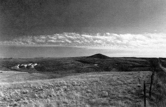
Figure 19--Lentil of silica-cemented sandstone at the top of the section noted in fig. 18. The lentil is up to 52 cm (1.7 ft) thick (rock hammer at arrow) and is stratigraphically and elevationally equivalent to the unit capping the hill a short distance to the north-northeast.
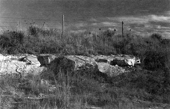
Figure 20--Mortar bed exposed stratigraphically below [5.5 m (18 ft)] the lentil depicted in fig. 19 (rock hammer for scale). Maximum exposed thickness of the bed is l.3 m (4.3 ft).
Where the silica-cemented sandstone (and conglomerate) is exposed, typically at topographic highs, it is designated with the single letter s on the county geologic map (W. C. Johnson and Arbogast, 1993).
Quaternary System--Pleistocene Series
Classically, the Pleistocene has consisted of four glacial advances, or stages: the Nebraskan, Kansan, Illinoian, and Wisconsin (fig. 3). In recent years this traditional Pleistocene chronology has been largely abandoned because of the complexity of the stratigraphic record and faulty correlations made by early researchers. Within the United States ten preIllinoian glaciations have been recognized, seven of which occur in the Pleistocene (three in the Pliocene). In Iowa and Nebraska alone pre-Illinoian time is known to contain deposits from one Pliocene and five Pleistocene glaciations (Richmond and Fullerton, 1986a), and during the last 900,000 years there have been eleven episodes of glaciation in the United States (Fullerton and Richmond, 1986).
Many of the stratigraphic correlations have been made on the basis of a volcanic ash marker bed, the Pearlette (Frye and A. B. Leonard, 1952; Schultz and Martin, 1970). Although Swineford and Frye (1946) documented the presence of many ashes in Kansas, researchers continued to acknowledge the existence of only one, isochronous "Pearlette" ash. In the last two decades, three separate Pearlette ashes and three other ashes have been identified and named in the Central Plains (table 2). Petrographic and chemical analyses (Izett et al., 1970; Izett, 1981; Izett and Wilcox, 1982) and fission-track dating (Boellstorff, 1973, 1974, 1976; Naeser et al., 1973) have been used to differentiate the three Pearlette ashes. Reed and Dreezen (1965) concluded that two tills in northeastern Nebraska were Illinoian in age because of their position above "the ash," but subsequent fission-track dating of the ash by Boellstorff (1978a,b) produced an age of approximately 1.2 Ma, that is, the Pearlette S ash. Those tills are now known to be older than classic Kansan till. Similarly, Boellstorff (1976) dated the "Pearlette ash" marker bed, assumed to date to about 600 ka, at the Sappa type section in Harlan County, Nebraska (county north of Phillips); its date was 1.26 ± 0.40 Ma, indicating that Sappa deposits are early Pleistocene, that is, not correlated with the classical Kansan glaciation but 500,000 years or more older. Martin and Schultz (1985) corroborated this finding by noting that the Sappa local fauna, situated about 2 m (7 ft) below the ash, is post-Blancan, pre-Kansan.
Table 2--Fission-track-dated volcanic ashes of major stratigraphic significance in the Central Plains (Nebraska, Kansas, and Oklahoma).
| Ash | Alternative names |
Source area |
Representative age (xl06 yr) |
|---|---|---|---|
| Pearlette O | Pearlette restricted, Lava Creek B, Cudahy, Hartford |
Lava Creek Tuff, Member B, Yellowstone |
0.610 |
| Bishop | Mount Clare | Bishop Tuff, California |
0.738 |
| Tsankawi | Toledo & Valles Caldera, NM |
1.12 | |
| Pearlette S | Coleridge, Mesa Falls |
Mesa Falls Tuff, Yellowstone |
1.27 |
| Guaje | Toledo & Valles Caldera, NM |
1.45 | |
| Pearlette B | Huckleberry, Ridge, Borchers |
Huckleberry Ridge Tuff, Yellowstone |
2.01 |
| Sources: Boellstorff (1976), Izett (1981, 1982), Izett and Wilcox (1982), Richmond and Fullerton (1986a), and Ward (1991). |
|||
Regionally, the question remains of whether the use of "Kansan" in the type area of northeastern Kansas is appropriate. Since the term "Kansan" was introduced by Chamberlin (1895), northeastern Kansas has persisted as the type region for deposits identified with the Kansan glaciation (Frye and Leonard, 1952), despite reliance on the glacial stratigraphy of Nebraska and Iowa for interpretation (Jewett, 1963). Aber (1981,1988,1991) recognized two advances during Kansan glaciation in northeastern Kansas on the basis of lithologic differences in the glacial stratigraphy. Evidence for three or more advances has, however, been cited by Bayne (1968), Bayne et al. (1971), and Dort (1966, 1985). Subsequently, Aber (1991) identified two diamictons in northeastern Kansas, which he included in a new lithostratigraphic unit, the Independence formation, a term intended to replace the traditional name of "Kansan." Aber et al. (1988) dated glaciation in northeastern Kansas on the basis of volcanic ash and paleomagnetism to between 700 and 600 ka, thereby associating the glacial activity with oxygen isotope stages 18-16 (Aber, 1991). Elsewhere in northeastern Kansas (Marshall County), Oviatt (1991), using geochemical and magnetic qualities of a volcanic ash, dated glacial deposits as older than 620 ka and younger than 730 ka. These two ages on glacial deposits in northeastern Kansas are similar and indicate that the deposits are different from "Kansan" deposits in Iowa and are younger than the Lava Creek Bash.
Because the Nebraskan and Kansan glacial stages and the Aftonian and Yarmouthian interglacial stages no longer appear to be appropriate stratigraphic designations in their type regions, most investigators have called for abandonment of the classical pre-Illinoian stratigraphic framework [e.g., Hallberg et al. (1980), Dort (1987), Hallberg (1986), and Richmond and Fullerton (1986a)]. The classical stage names have been used in chronostratigraphic, lithostratigraphic, pedostratigraphic, and event-stratigraphic contexts, and continued adherence to the nomenclature will likely propagate the error and confusion (Hallberg, 1986, p. 12). Boellstorff (1978b) was among the first to call for a new regional stratigraphic framework for the Central Plains.
Richmond and Fullerton (1986a) presented an informal scheme of geologic divisions and associated time scale for the Quaternary of the United States (fig. 21). The PliocenePleistocene boundary was set at 1.65 Ma, in accordance with the estimate of 1.64 Ma derived by Aguirre and Pasini (1985) on the basis of radiometric ages from the Virca section in Italy; this move has apparently resolved the problem of identifying an appropriate stratotype (Rio et al., 1991). Until recently, one age commonly proposed for the boundary was 2.4 Ma (Bowen, 1978; Nilsson, 1983; Pecsi, 1985). The boundary is strictly geochronometric, that is, without stratigraphic basis, in the United States, primarily because many have attempted to define it climatically [e.g., Beard (1969), Lamb and Beard (1972), Boellstorff (1978c), and Beard et al. (1982)]. Specifically, the boundary cannot be located stratigraphically and has no significance to the stratigraphic and chronologie sequence of glaciation, to the history of vertebrate fauna of the North American land mammal ages, or to the record of climatic or environmental change (Richmond and Fullerton, 1986b). For the central Great Plains, Boellstorff (1976) has argued for a change to l.8 or 2.0 Ma on the basis of land mammal ages or a major ash marker bed, respectively.
Figure 21--Quaternary time scale. Modified from Richmond and Fullerton (1986a, p. 6). Notes: (a) Marine oxygen isotope stages 1-22 are from Shackleton and Opdyke (1973, 1976), and stages 22-40 are from van Donk (1976). (b) Pleistocene-Holocene (2-1 isotope stage) boundary after Hopkins (1975). (c) Ages of marine isotope boundaries interpreted by Richmond and Fullerton (1986a) from graphic data presented by R. G. Johnson (1982). (d) Ages of the marine isotope boundaries taken from Martinson et al. (1987, table 2). Values were derived using the Milankovitch orbital tuning technique. (e) K-Ar age of the Lava Creek tuff and Pearlette O volcanic ash bed. Adopted by Richmond and Fullerton (1986a). (f) Astronomical age of the Matuyama-Bruhnes magnetic polarity reversal derived by R. G. Johnson (1982) and adopted by Richmond and Fullerton (1986a). (g) Age of the Pliocene-Pleistocene boundary at the Virca, Italy, section (Aguirre and Pasini, 1985). (h) The "Eowisconsin" is a time interval characterized by the existence of limited glaciation preceding the extensive Wisconsin glaciation (W. H. Johnson, 1986; Richmond and Fullerton, 1986a). The terrestrial record for this interval is yet restricted to the mountains of the western United States (Richmond and Fullerton, 1986b); in the central United States the interval is characterized by development of the Sangamon soil (Oviatt et al., 1988; Forman, 1990a; Forman, Bettis et al., 1992). (i) Richmond and Fullerton (1986a) defined the Illinoian glacial stage as marine isotope stages 6-8 based on the terrestrial glacial record, whereas the Illinoian is alternatively defined as isotope stage 6 using the marine isotope surrogate of climate. The beginning and end of isotope stage 6 (Illinoian glacial stage) has been dated using a geomorphic approach: Oviattet al. (1988) reported thermoluminescence dates of 130 ± 30 ka and 136 ± 30 ka on the upper part of the presumed Loveland Loess in northeastern Kansas; Forman, Bettis et al. (1992) reported thermoluminescence ages of 125 ± 25 ka and 165 ± 20 ka on the mid-upper and lower parts, respectively, of the Loveland Loess in Illinois; isotopic dating of fossil coral reefs has placed the beginning of the Illinoian at 180-200 ka (Bender et al., 1979), and the end at somewhat less than 125 ka (Ku et al., 1990) and about 120 ka (Edwards et al., 1987a,b; Bard et al., 1990; Chen et al., 1991).
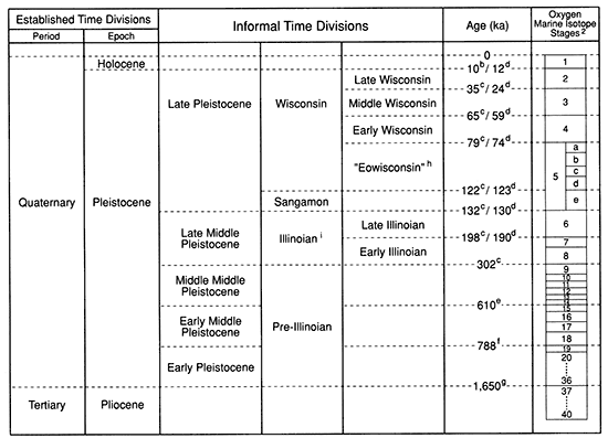
The Pleistocene was subdivided by Richmond and Fullerton (1986a) into early, middle, and late, with the middle being further broken down into early middle, middle middle, and late middle Pleistocene. In most instances numerical ages of the boundaries were arbitrarily set within the period of radiometric dating and the marine 18O. Exceptions were stratigraphic markers at the early-middle Pleistocene boundary at 788 ka (Matuyama-Brunhes polarity reversal) and the early middle-middle middle Pleistocene boundary at 610 ka (Lava Creek tuff and Pearlette O volcanic ash).
A good empirical relationship exists between cold stages in the marine oxygen isotope record and documented times of glaciation (ice volume) in the United States (Richmond and Fullerton, 1986a). Given the close correspondence between the glacial record and the marine isotope record and the fragmentary nature of the glacial record, it follows that the nearly continuous loessal record should be an excellent terrestrial cognate of the marine isotope record. Therefore the climatic and chronologie record assembled for the marine sequence should match the loessal record well. The generally accepted model relating climate to the loessal record indicates that periods of stability and pedogenesis were usually associated with warm interglacial periods and that periods of significant loess accumulation coincided with the colder glacial times (Kukla 1977,1987). Morphologic and isotopic analyses of plant opal phytoliths from loess exposed at the Eustis ash pit in southwestern Nebraska support the model and the relationship with the marine isotope record for the Illinoian, Sangamon, and early middle Wisconsin stages (Fredlund et al., 1985; Fredlund, 1990).
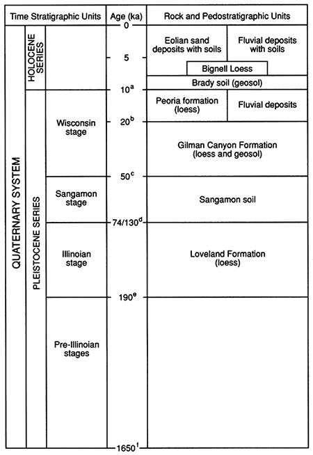
The late Quaternary stratigraphic succession for Phillips County is represented in fig. 22. Pre-Illinoian deposits are recognized in Phillips County but only in limited areas. Illinoian deposits occur more extensively but are restricted to certain stratigraphic and depositional contexts. Wisconsin sediments are widespread, with appreciable surface expression.
Figure 22--Late Quaternary stratigraphic succession in Phillips County. Notes: (a) Pleistocene-Holocene boundary after Hopkins (1975). This appears to be the time of major glacial-nonglacial environmental change in the central Great Plains, as recorded in the pedological record (W. C. Johnson and May, 1992). (b) The uppermost Gilman Canyon Formation dates to about 20 ka (see table 3 and fig. 26). (c) The date of 50 ka is only an estimate of the end of Sangamon time and reflects the current lack of data and apparent time-transgressive nature of the Sangamon soil (Follmer, 1983; Bowen et a1., 1986, chart 1). Selection of the age is based on the relatively young age of the lower Gilman Canyon Formation (see table 3 and fig. 26; W. C. Johnson et a1., 1993) and a similar basal age reported by Leigh (1991) on the correlative Roxana silt of the upper Mississippi valley. (d) The date of 74 ka (isotope stage boundary 4-5a), taken from Martinson et al. (1987, table 2), was derived using the Milankovitch orbital tuning technique. This date was selected because it is consistent with thermoluminescence ages from below the Sangamon soil in Illinois (Forman, 1990a; Forman, Bettis et al., 1992) and in central Kansas (Feng, 1991). The date of 130 ka (isotope stage boundary 5e-6), also taken from Martinson et a1. (1987), represents the isotopically defined end of Illinoian glaciation (see fig. 21, note i). (e) Age of marine isotope boundary 6-7 as determined by Martinson et al. (1987). An alternative date of 302 ka has been proposed for the lower Illinoian (Richmond and Fullerton, 1986a; see fig. 21, note i). (f) Age of the Pliocene-Pleistocene boundary at the Virca, Italy, section (Aguirre and Pasini, 1985). No deposits of this age are believed to exist in Phillips County; the oldest are probably of upper pre-llIinoian age, that is, those classically referred to as the Meade formation of the Kansan Stage. Glacial deposits of northeastern Kansas have been dated to less than 700 ka (Aber, 1988; Oviatt, 1991).
Pre-Illinoian stages
The nonglacial component of preIllinoian time (classical Kansan stage) originall y consisted of the Meade formation, which in turn was subdivided into the Grand Island and Sappa members. Frye and Hibbard (1941) described and designated a type locality for the Meade formation in Meade County, Kansas, and Hibbard (1949, 1958) later renamed the deposits at the type locality as the Crooked Creek Formation, deferring the name Meade formation to deposits in Clark County. In general, the deposits of the Meade formation are coarse textured at the base and grade upward into finer textured clastics with isolated lenses of volcanic ash. They occur in the northwestern part of the state as discontinuous and often obscure terrace-fill remnants within the major valleys. Stratigraphically equivalent deposits in Nebraska were designated the Grand Island Formation (Lugn, 1934, 1935) and the Sappa Formation (Condra et al., 1950). These names were adopted in Kansas, but at the member level within the Meade formation (Frye and Leonard, 1952). The name of Meade formation was subsequently abandoned, and the Grand Island and Sappa units were elevated to the formation level (Bayne and O'Connor, 1968).
Grand Island and Sappa Formations Absolute time control by means of fission-track, thermoluminescence, and other dating techniques and regional correlation may eventually validate continued use of "Grand Island" and "Sappa" as formation names or equivalents. The two names are used in this brief discussion but are of unknown pre-Illinoian age because the type sections have not been stratigraphically correlated with adjacent units in Nebraska. The two formations are combined here because they represent at most localities a continuous depositional sequence and because they have no currently known surface exposure in Phillips County; however, they have been encountered in subsurface exploration associated with this study.
Gravel, sand, and minor amounts of silt make up the Grand Island Formation, which occurs in northwestern Kansas as fill beneath a highly dissected terrace in major stream valleys with an average thickness of approximately 20 ft (6.1 m) (Bayne and O'Connor, 1968, p. 66). Lugn (1935) considered the Grand Island Formation to be of Kansan age, but Wayne and Aber (1991) believe it to be younger, at least in part. The Sappa Formation is composed of alluvial silt and to a lesser extent sand and conformably overlies the Grand Island. Lentils of Pearlette volcanic ash have been found locally within the upper Sappa (Frye and Leonard, 1952).
Frye and A. R. Leonard (1949, pl. 3) mapped limited deposits of Meade formation south of Long Island on the south side of Prairie Dog Creek valley in the northwestern part of Phillips County; these deposits were relocated for this study but are buried beneath a loess mantle. An extraordinary exposure created in 1953 during excavation of the cutoff trench for construction of Kirwin Dam is considered the most complete middle and late Pleistocene sequence documented in northwestern Kansas. This outcrop yielded a molluskan faunal assemblage surpassed by only one other exposure in Kansas (Frye and Leonard, 1954). An abandoned valley of the ancestral Solomon River was cut into the Niobrara Chalk and Carlile Shale and was filled with a sequence including the Grand Island and Sappa Formations. In its upper part the Sappa contains Pearlette volcanic ash and is capped by an extremely well-developed Yarmouthian soil, which was in turn overlain by Illinoian deposits: the Crete Formation and the Loveland Loess. Frye and Leonard (1954) noted that the Sappa Formation can be verified only through its molluskan fossil assemblage because the Pearlette volcanic ash is not always present. The molluskan assemblage, however, may be reflecting a 1.2-Ma record, not one of 610 ka, given the 1.27-Ma age of the ash at the type locality (Boellstorff, 1976).
Illinoian Stage
All Pleistocene deposits, Illinoian and younger, were originally included in the Sanborn formation. Consequently, the formation differed from all others in that it included two glacial stages and substages as well as two major unconformities, namely, the Sangamon and Brady soils. The Sanborn formation was originally considered a convenient term for designating the unconsolidated Pleistocene deposits, primarily for mapping purposes. The name "Sanborn" was given to unconsolidated deposits by Elias (1931) in northwestern Cheyenne County, Kansas. Subsequently, Frye and Fent (1947) designated a Sanborn type section and subdivided the formation into three members: the Loveland silt, the Peoria silt, and the Bignell silt members. Frye and A. B. Leonard (1949) recognized a fourth member underlying the Loveland silt: the Crete sand and gravel. Because of subdivision into discernible, mappable units, use of the Sanborn formation designation has become inappropriate. Also, confusion results from the name Sanborn Group being used for a thick siltstone exposed in the Borchers Badlands, Meade County, Kansas, which has been dated (fission-track dating) to 1.08 Ma (Carter and Ward, 1991). In 1959 the Kansas Geological Survey abandoned the name Sanborn formation, elevated its members to the rank of formation (Jewett, 1959), and later defined phases within the formations (Bayne and O'Connor, 1968).
Because the Crete sands and gravels are not exposed and because the loesses and associated soils are difficult if not impossible to map individually, the loesses and their soils were undifferentiated, that is, mapped together as Ql on the county geologic map (W. C. Johnson and Arbogast, 1993).
Crete Formation The Crete sand and gravel was deposited as channel fill, presumably during the Illinoian Stage, and is probably a complex deposit composed of several cut-and-fill sequences. Lugn (1935) included both eolian and alluvial sediments in the original Loveland unit, but Condra et al. (1947) differentiated the sand and gravel from the loess and instituted the name Crete Formation for Nebraska. In north-central Kansas the Crete is well represented, locally as gully fills and on a larger scale as terrace deposits along the north side of major river valleys (Frye and Leonard, 1952, p. 112). In all instances the lithology of the Crete sand and gravel is consistent with that of the drainage basin within which the deposits occur.
In Phillips County the Crete Formation is well developed and present nearly continuously along the valleys of Prairie Dog Creek in the northwest corner of the county and the North Fork Solomon River. Surface and subsurface exploration in both valleys has indicated the presence of gravels beneath the terrace along the north side of the valleys. Wisconsin loesses have accumulated on the terrace, obliterating the characteristic terrace scarp morphology such that the terrace is typically indistinguishable morphologically. This is particularly true of Prairie Dog Creek, where loess has filled in small drainage ways and removed any expression of the heel or toe of the terrace. On the North Fork Solomon River, the Wisconsin loess mantle is somewhat thinner, usually preserving the characteristic terrace form. The town of Glade is situated on the Illinoian terrace mantled by the younger loesses (Gilman Canyon and Peoria). This relationship is also evident at the town of Speed but to a lesser extent. Because of the loess covering, the Crete sand and gravel were not mapped in this study (W. C. Johnson and Arbogast, 1993).
The best age information for the Crete Formation in Phillips County comes from an exposure within an abandoned railroad cut west of Woodruff (see fig. 15). A section exposing sand and gravel overlain by loess (the Gilman Canyon and Peoria formations) and underlain by the Ogallala Formation was first described at this locality by Frye and A. R. Leonard (1949) as the Crete Formation. Subsequently, Frye and Leonard (1952) reinterpreted the deposits below the Gilman Canyon Formation as Grand Island sand and gravel with overlying Sappa silt. The Grand Island Formation reportedly contained a diagnostic molluskan fauna, and the deposit apparently occupies a topographically but not stratigraphically higher position than the Illinoian Crete deposits on the north side of the valley wall. The potential for the molluskan fauna to discriminate between the Crete and Grand Island Formations is unknown. The vertical distance between the formations, however, is not a significant factor, given the apparent variability of the top of the Crete elsewhere in the county. Results of this study indicated that a soil exposed within the silt is the late Wisconsin Gilman Canyon Formation. Furthermore, a tooth found by D. W. May was identified by L. D. Martin (personal communication, 1991) as a molar from the wild ass (Equus cumminsii or Asinus sp.; Kurten and Anderson, 1980, p. 287-288) and of a relatively young age (not pre-Illinoian).
Based on information currently available for Nebraska, Wayne and Aber (1991) suggested that the names "Grand Island" and "Crete" reference the same sedimentary unit, and they opted to discontinue use of the name "Crete Formation."
Loveland Loess The Loveland Loess is the most widespread pre-Wisconsin loess in the midcontinent. Several investigators [e.g., Reed and Dreeszen (1965), Ruhe (1969), Willman and Frye (1970), and Ruhe and Olson (1980)] have described it throughout the Missouri, Mississippi, and Ohio River basins. Furthermore, it has been recognized south into Mississippi and Arkansas (McCraw and Autin, 1989). The Loveland Loess has been far less studied (e.g., absolute chronology, geometry, mineralogic composition) than the Wisconsin loesses, especially the Peoria.
Shimek (1909) first identified the Loveland (as a waterlaid deposit) based on exposures along the east bluff of the Missouri River northeast of Loveland, Iowa, where the unit is underlain by Kansan till and overlain by Wisconsin loess. Several years later, the Loveland was identified and described in Nebraska by Lugn (1935), who identified both a valley phase (waterlaid) and an eolian phase (loess). Condra et al. (1950) separated the valley phase, naming it the Crete Formation. Since Leighton and Willman (1950) first designated the Loveland as an Illinoian-age loess, it has been assigned as such in both Kansas (Frye and Leonard, 1952) and Nebraska (Wayne, 1963; Reed and Dreeszen, 1965). Frye and Fent (1947) identified the Loveland Loess in Kansas on the basis of comparisons made with the type section in Iowa and deposits recognized in Nebraska. More recently, the Loveland of Nebraska has been separated into three distinct units, or members, based primarily on the presence of paleosols (Reed and Dreeszen, 1965; Schultz, 1968; Schultz and Martin, 1970). The original type section of the Loveland Loess was destroyed by a borrow pit for road construction, and a new type section (paratype) was designated at the end of the borrow pit area (Daniels and Handy, 1959; Bettis, 1990).
The Loveland can be described as a yellowish-brown or reddish-brown eolian silt. Red hues increase toward the top of the formation because of development of the Sangamon soil within the uppermost Loveland. The thickest accumulations occur in north-central Kansas; recorded thicknesses approach 15 m (49 ft). A thinning in the loess occurs both southward and westward such that the distribution becomes discontinuous to the southwest. In Phillips County the Loveland is typically less than 12 m (39 ft) thick, but it produces a distinctive mark on the landscape because of its variation in stratigraphy; it occurs on uplands and valley side slopes. As a result, the Loveland and its capping Sangamon soil are well expressed in natural exposures and particularly in freshly cultivated fields (fig. 23).
Figure 23--Loess stratigraphy exposed in a cultivated field. The arrows, from top to bottom, indicate the modern surface soil, the Peoria loess, the Gilman Canyon Formation, the Sangamon soil, and the Loveland Loess. This view is west-southwest from the north-south section line road in the southern half of sec. 17, T. 1 S., R. 20 W.
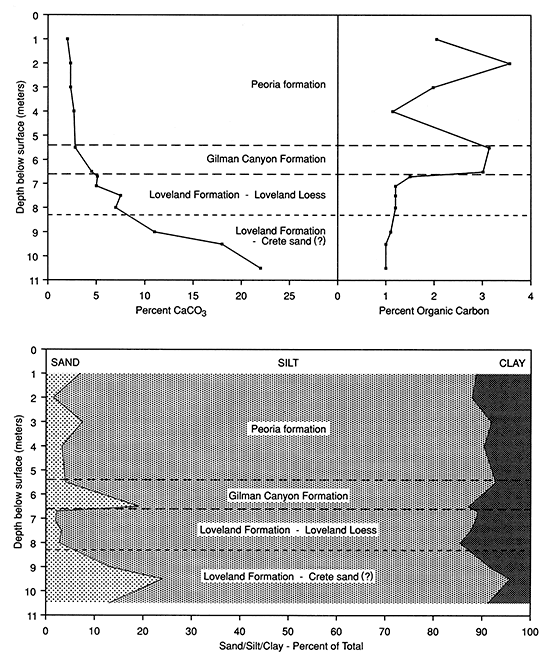
Several paleosols of varying degrees of development are present within the Loveland Loess, indicating periodic stability or at least dramatically decreased rates of loess fall. These soils were observed by Frye and Leonard (1954, p. 47) in the cutoff trench created during the construction of Kirwin Dam. Excavation of a trench at the Phillips County sanitary landfill near Phillipsburg provided the best upland exposure of Loveland and post-Loveland deposits in Phillips County for this study. Sampling at the site was not extensive but represents the major strata present. Standard laboratory analyses provided characterization of the sediments and pronounced definition of the stratigraphy (fig. 24). The relatively high carbonate content within the Loveland is consistent with observations elsewhere in Kansas. Textural variation within the Loveland reflects the presence of a sandy unit approximately 9-10 m (30-33 ft) below the surface; this unit has been recognized in central Kansas by Feng (1991) and may have equivalents in Nebraska. Feng named this unit the Barton sand, dated it as 95-70 ka, and detected three weathering zones within it.
Figure 24--Particle size distribution, calcium carbonate content (%), and organic carbon content (%) of samples from the Phillips County sanitary landfill exposure. Data from Feng (1991).
The absolute age of the Loveland Loess is unknown for Phillips County, but Oviatt et al. (1988) reported thermoluminescence dates of 136 ka and 130 ka in the upper part of presumed Loveland Loess exposed in an abandoned quarry near Milford in northeastern Kansas. Thermoluminescence data from central Kansas sites indicate that Loveland Loess accumulation ended at about 70 ka, following a sandy phase that began about90ka (Feng, 1991; W. C. Johnson, 1991b). Four zones of carbonate enrichment, occurring at about 410- 360, 330-290, 250-200, and 130-95 ka, were interpreted to be pedogenic (Feng, 1991). Although Feng (1991) assigns all four carbonate zones to the Loveland stage, I believe that Illinoian time begins after the 250-200-ka carbonate accumulation. These carbonate zones are likely analogous to the soils observed in the Illinoian and pre-Illinoian loess at the Eustis ash pit (Fredlund et al., 1985) and elsewhere in the region (Schultz and Martin, 1970; Frye and Leonard, 1951). The zones are temporally equivalent to the nonglacial, or warm, marine isotope stages (Feng, 1991). Fossil pollen evidence indicates that the grasslands of the Great Plains expanded during the interglacial periods and contracted or perhaps disappeared during the glacial periods (Kapp, 1965, 1970; Fredlund and Jaumann, 1987). This suggests that the carbonate enrichment was a product of grassland pedogenesis, not unlike that of today. Fredlund et al. (1985) extracted grass opal phytoliths from the four soil zones at the Eustis ash pit in south-central Nebraska and found that the soilforming periods were warmer and the periods of dust accumulation cooler.
Dating results from the Loveland paratype section are consistent with data obtained from loess in northeastern and central Kansas. Four thermoluminescence ages for the Loveland Loess indicate that the sediment was deposited approximately 135 ka (Forman, 1990b; Forman, Bettis et al., 1992).
Sangamon soil The Sangamon soil is strongly developed and occurs throughout the midcontinent beneath deposits of the Wisconsin glaciation and within deposits of the Illinoian glaciation or older deposits. This paleosol has been recognized in Indiana (Hall, 1973; Ruhe et al., 1974; Ruhe and Olson, 1980), Illinois (Bushue et al., 1974; Follmer, 1979) where the type section is located (Follmer, 1978), Iowa (Simonson, 1941; Ruhe, 1956, 1969), Nebraska (Schultz and Stout, 1945; Thorpe et al., 1951), and Kansas (Frye and Leonard, 1952). In Kansas the Sangamon soil is well expressed, occurring throughout the state. The soil has received considerable attention in northeastern Kansas (Frye and A. B. Leonard, 1949, 1952; Tien, 1968; Caspall, 1970; Bayne et al., 1971; Schaetzl, 1986), but itis recognized throughout the state (Bayne and O'Connor, 1968) and was recently studied in central Kansas (Feng, 1991). Historically, the Sangamon soil has been referred to as a "soil in the Sanborn formation" (Hibbard et al., 1944), the Loveland soil (Frye and Fent, 1947), and the Sangamon soil (Frye and Leonard, 1951). The color of the soil ranges from a vivid to pale reddish brown, with a loss of color occurring westward. Regionally, the soil character varies according to the parent material, local drainage, and climate that prevailed at the time of pedogenesis. The soil occasionally contains sufficient clay to create a subtle bench on cultivated slopes. Schaetzl (1986) noted that the soil appears to be a strongly developed Ultisol or Mollisol.
The Sangamon soil was first used in a time-stratigraphic context to differentiate deposits of the Illinoian and Wisconsin glacial stages (Leverett, 1899). An appreciable time span for regional landscape stability and soil formation are indicated by intense oxidation, deep leaching, and high clay accumulation. The main problem associated with the Sangamon soil is its diachronous upper and lower boundaries (Follmer, 1978, 1982, 1983; W. H. Johnson, 1986). To further confuse the time element, the lower 1-2 m (3-7 ft) of the early Wisconsin loess is typically weathered and forms a pedologic continuum with the underlying Sangamon soil, and most investigators, until recently, mistakenly included the Wisconsin loess in the Sangamon profile (Follmer, 1983). The Sangamon soil should be considered a pedocomplex rather than a single soil that developed under unique environmental conditions (Schultz and Tanner, 1957; Fredlund et al., 1985; Morrison, 1987). It apparently represents several paleosols welded together to form a complex that reflects significant spatial and temporal variation in environmental conditions and an appreciable time span. Laboratory data from exposures in central Kansas indicate that the Sangamon soil was strongly weathered chemically, presumably under a warm, moist climate (Feng, 1991).
Because of apparent time transgressiveness, the age of the Sangamon soil is not precisely known. Follmer (1983) reported a radiocarbon age of 41,700 ± 1,100 yr B.P. on plant material from the top of the Sangamon in its type area in Illinois. The thermoluminescence ages of 136 ka and 130 ka reported by Oviatt et al. (1988) for the upper Loveland Loess of northeastern Kansas provide a maximum age for the Sangamon soil. Forman (1990a) and Forman, Bettis et al. (1992) reported thermoluminescence ages of approximately 135 ka and 77 ka from loess below the Sangamon soil at two sites in Iowa and Illinois and concluded that the Sangamon soil is diachronous and may consist of several soils. Feng (1991) and Feng et al. (1991) reported a thermoluminescence age of about 70 ka in the lowermost part of the Sangamon soil exposed in central Kansas and associated it with marine isotope stage 3. Although Richmond and Fullerton (1986b) assign Sangamon time to 132-122 ka (isotope substage 5e; see fig. 21), they acknowledged reported ages (relative and absolute) ranging from early Illinoian to middle Wisconsin. Basal ages on the overlying Gilman Canyon Formation from Phillips County and elsewhere in Kansas and Nebraska provide a minimum age of about 35 ka for the Sangamon soil (W. C. Johnson et al., 1990). Also, Forman (1990b) and Forman, Bettis et al. (1992) obtained basal thermoluminescence and radiocarbon ages of 35-30 ka within the loess overlying the Sangamon soil at the Loveland paratype section in Iowa and the Pleasant Grove School section in Illinois.
Post-Sangamon time was one of extensive landscape instability, including upland erosion, as evidenced by the partial or complete removal of the Sangamon soil. In the quarry near Woodruff (see fig. 15) the Loveland and Sangamon have been removed and the top of the Ogallala has been eroded. Similarly, the same units may have been stripped and channels cut into the Smoky Hill Chalk Member before deposition of the Gilman Canyon Formation (see fig. 7). Consequently, erosional truncation of the soil may be responsible in part for the apparent diachrony of the soil. Deposition occurred at some locations; a sandy eolian zone overlying the Sangamon soil in the Phillips County sanitary landfill (see fig. 24) suggests a dry and windy transition to the Gilman Canyon Formation above.
Wisconsin Stage
As the most recent glacial episode, the Wisconsin has the greatest resolution and has been traditionally defined with five substages. It is generally accepted that the stage began approximately 79,000 to 70,000 years ago according to radiocarbon dating. The substages, as defined in Illinois, include the Altonian (70,000-28,000 yr B.P.), the Farmdalian (28,000-22,000 yr B.P.), the Woodfordian (22,000-12,500 yr B.P.), the Twocreekan (12,500-11,000 yr B.P.), and the Valderan (11,000-5,000 yr B.P.) (Willman and Frye, 1970; Frye and Willman, 1973). Frye and Leonard (1965) referred to the Altonian, Farmdalian, and Woodfordian substages collectively as the pre-Bradyan and the Valderan as the post-Bradyan, the name Brady coming from the Brady soil. Time divisions within the Wisconsin have since been rescaled and renamed (see fig. 21); the stage is defined as extending from 122 ka to 10 ka, or isotope stages and substages 5d through 2. Divisions consist of the Eowisconsin, and the early, middle, and late Wisconsin. The Eowisconsin is represented by limited glaciation in the western United States and may coincide with continued development of the Sangamon soil.
The Wisconsin rock-stratigraphic units recognized in Phillips County consist of early to middle Wisconsin fluvial deposits, the Gilman Canyon Formation (loess), the Peoria loess, and late Wisconsin fluvial deposits. As noted, the Loveland Loess, Sangamon soil, Gilman Canyon Formation, and Peoria loess of Phillips County were mapped in an undifferentiated fashion as Ql (W. C. Johnson and Arbogast, 1993). The early to middle and late Wisconsin fluvial deposits are undifferentiated and not mapped per se but are represented by the map designation Qt because both underlie the high terrace in the valley bottoms.
Early to middle Wisconsin fluvial deposits Fent (1950) and Frye and Leonard (1952) noted that valleys of major Kansas streams became entrenched below the level of earlier valley floors during the late Illinoian or early Wisconsin. This is particularly true for the valleys of northern Kansas, including Phillips County. Accordingly, early Wisconsin fill occupies a basal position in the present bedrock valleys and is overlain by late Wisconsin and Holocene stream deposits. Exposures of this fill are therefore exceedingly rare, and earlier studies (Frye and Leonard, 1952, 1965) report its presence exclusively from drillhole data. Frye and Leonard (1952, 1965) assume that the sand and gravel from drillholes within terrace fill are of early to middle Wisconsin age and cite the truncation of Illinoian deposits as evidence. The fill reaches thicknesses of 90 ft (27 m), fines upward rapidly near the top, and underlies an extensive terrace 15-35 feet (4.6-11 m) above the present channel, which has been recognized throughout much of the Kansas River basin. Specific terrace identifications include the Newman terrace of the lower Kansas River valley (Davis and Carlson, 1952), the Schoenchen terrace of the Smoky Hill River valley (Leonard and Berry, 1961), the Almena terrace of Prairie Dog Creek (Frye and A. R. Leonard, 1949), the Kirwin terrace of the North Fork Solomon River valley (Frye and A. R. Leonard, 1949; A. R. Leonard, 1952), the Schoenenburg terrace of the Republican River valley (Martin, 1990), and other unnamed terraces in smaller tributaries. The widespread distribution of these potentially correlative surfaces indicates a Kansas River basinwide sequence of alluvial events in the late Wisconsin.
Although the Almena and Kirwin terraces and one unnamed terrace in Bow Creek occur within Phillips County, the Kirwin is the most extensive. The only exposure of early Wisconsin alluvium occurs in the Siebert gravel pit, 3 km (1.9 mi) east of Glade in SW NE sec. 29, T. 4 S., R. 18 W. (fig. 25). The site is a remnant of early to middle Wisconsin fill beneath the Kirwin terrace. The alluvium is overlain by 6.07 m (19.9 ft) of silt (Gilman Canyon and Peoria formations) and extends to at least 9.1 m (30 ft) below the water table, providing a total exposed thickness of approximately 17 m (56 ft). Lithologically, the alluvium is a mixture of the Niobrara Chalk and Ogallala-derived sand and gravel. A maximum age of early Wisconsin is indicated by the inset position of the alluvium within the Crete gravel along the adjacent valley wall to the north and by two radiocarbon ages determined from a buried soil in the silt overlying the alluvium. The radiocarbon ages, obtained from the uppermost and lowermost 5 cm (2 in.) of the soil A horizon, are 24,270 ±750 yr B.P. (Tx-6624) and 35,590 ± 2260 yr B.P (Tx-6625), respectively (W. C. Johnson, 1990). Wisconsin fluvial deposits exposed are here older than 35,000 years, but the absolute age is unknown.
Figure 25--Kirwin terrace and fill exposed in the Siebert gravel pit. The north exposure of the pit reveals a loess cap (vertical face) on early Wisconsin fill. A buried soil (arrow) developed within the loess was radiocarbon-dated to produce ages of 33,590 ± 2260 yr B.P. (Tx-6625) and 24,270 ± 750 yr B.P. (Tx-6624) on the lowermost and uppermost 5 cm (2 in.) of the A horizon, respectively. The view is from the southwest corner of the pit, located in SW NE sec. 29, T. 4 S., R. 18 W.
The Gilman Canyon Formation, first recognized in Nebraska (Reed and Dreeszen, 1965), is an early late Wisconsin (Farmdalian) loess (see figs. 21 and 22). Equivalents of the formation have been recognized elsewhere; the Loveland Loess is buried by the Roxana silt from Minnesota and Wisconsin to Arkansas and by the Pisgah formation in western Iowa (Bettis, 1990). The Gilman Canyon of Nebraska and Kansas is typically dark colored, silty, leached of calcium carbonate, and heavily enriched in organic carbon through pedogenesis (melanization). It was once considered to be the attenuated A horizon of the Sangamon soil (Thorpe et al., 1951; Reed and Dreeszen, 1965).
Reed and Dreeszen (1965) provide limited textural data and description of the Gilman Canyon Formation at the type section. Their description within the columnar section at the Buzzard's Roost exposures states (p. 62): "Upper 12 inches [31 cm] is medium dark gray, slightly humic, silt; middle 1 foot 1 inch [33 cm] is light brownish-gray silt; basal 3 feet 8 inches [1.1 m] is dark brownish-gray, humic, soil-like silt; entire thickness is noncalcareous … 5 feet 9 inches [1.8 m]." Although all these attributes described at the type section are observed in Nebraska and Kansas, the bimodal distribution of humus is curious; it suggests the existence of two periods of relative stability, or low accumulation rates, and an intervening period of accelerated accumulation rates. Consequently, the Gilman Canyon Formation often appears as one or more cumulic A horizons that are developed within a variably to noncalcareous loess, usually no more than l.2 m (4 ft) thick. In a section revealing an expanded valley phase of the Gilman Canyon Formation, May and Souders (1988) recognized three distinct organic zones, each of which may represent a distinct episode of pedogenesis. I have recently observed two such zones at the Eustis ash pit in south-central Nebraska. If two or more distinct periods of soil formation did occur regionally, they are obscured at many localities, perhaps because of bioturbation. Overall, the formation reflects a sufficiently slow rate of loess fall (0.08 mm/yr) such that pedogenesis was operating more or less continuously but with a decreased intensity at one or more times.
As expressed, the Gilman Canyon Formation is frequently overlain by 0.9-l.5 m (3-5 ft) of leached loess, which is considered basal Peoria formation. Correlative with the Gilman Canyon and overlying leached loess zone is the Citellus zone (Citellus was a ground squirrel now recognized as the genus Spermophilus) of Nebraska (Condra et al., 1950). The leached zone is transitional between the welldeveloped A horizon(s) in the Gilman Canyon and the calcareous Peoria loess above and probably reflects a sufficiently slow accumulation of Peoria loess such that pedogenesis could keep pace only partially. A. B. Leonard (1951, 1952) supports the contention that the leached, or basal zone was a slowly accumulating early Peoria loess experiencing pedogenesis; Leonard inferred that gastropods were originally present but were subsequently destroyed during weathering. Above the leached zone the rate of accumulation of Peoria loess was sufficiently rapid (0.6 mm/yr) to preclude any soil development.
McKay (1979a, b) noted in Illinois that radiocarbon ages on organic materials from within early Wisconsin loess range from 40,000 to 31,000 yr B.P., and he extrapolated an age of 45,000 yr B.P. for the initiation of loess deposition. Furthermore, McKay (1979b) placed the end of the Farmdalian at about 25,000 yr B.P., that is, when Woodfordian (Peoria) loess fall began. As noted, Forman (1990a) and Forman, Bettis et al. (1992) reported thermoluminescence and radiocarbon ages of 35-30 ka for the loess immediately above the Sangamon. Follmer (1983, p. 141) indicated that about 5,000 years separates the first deposition of glacially derived loess and the time of maximum Woodfordian glacial extent in Illinois at about 20,000 yr B.P. This 5,000-year period may coincide with that for the development of the leached zone overlying the well-developed (organic-enriched) part of the Gilman Canyon. Radiocarbon ages obtained from the Roxana silt in the Upper Mississippi River valley indicate that the loess unit was deposited between 50 and 27 ka (Leigh, 1991).
Radiocarbon ages from the Gilman Canyon Formation range from approximately 35,000 yr B.P. at the base to 20,000 yr B.P. at the top (May and Souders, 1988; W. C. Johnson et al., 1990). Table 3 and fig. 26 present radiocarbon ages for the Gilman Canyon Formation of Nebraska and Kansas, and fig. 27 designates the locations from which the age data were obtained. The basal age of 35 ka agrees well with the time set by Richmond and Fullerton (1986a) (see fig. 21) for the beginning of the late Wisconsin. Although Nebraska has several dated locations forming an arcuate pattern around the eastern and southern sides of the Sand Hills, data come from only three areas in Kansas: Phillips, Barton, and Pratt counties. The ages in Kansas do show, however, good agreement between the south-central and north-central parts of the state and with ages from Nebraska.
Table 3--Gilman Canyon Formation radiocarbon agesa
| Location | Source | Age (sample) |
|---|---|---|
| Nebraska | ||
| WI, Winslow Hillb | Dreeszen, 1970 | 23,000 ± 600 (I-2191) 31,400 + 1800, -1500 (I-2192) |
| YA, Yankee Hill | Reed et al., 1966 | 26,900 + 1000, -900 (I-2189) 34,900 + 2100, -1700 (I-2190) |
| YO, depression near York (auger holes) |
Krueger, 1986 | 20,940 ± 240 (Beta-12273) 23,740 ± 220 (Beta-12272) 28,350 ± 610 (Beta-12274) |
| CE, Central City | Martin and Dort, 1987 | 19,640 + 230, -240 (DIC-3118) |
| ON, depression near Ong (core holes) | Kuzila, 1988 | 22,590 ± 280 (Beta-24268) 24,990 ± 430 (Beta-23457) 26,140 ± 530 (Beta-23456) |
| SO, UNL South-Central Research Extension Center (core hole) |
Kitchen, 1987 | 20,220 ± 330 (Beta-20102) |
| SP, Spring Ranch | Kuzila, 1988 | 21,140 ± 220 (Beta-20105) 33,950 ± 290 (Beta-20104) |
| FU, Funk | Souders and Dreeszen, 1991 | 24,260 ± 260 (Beta-40551) |
| BO, Bone Cove | C. Martin and Johnson, unpub. data, 1992 |
26,330 ± 400 (PITT-0826)c |
| Martin, 1990 | 26,260 ± 680 (Tx-5910) | |
| NO, North Cove | W. C. Johnson, unpub. data, 1991 |
27,850 ± 830 (Tx-7073)c 29,950 ± 900 (Tx-7074)c 30,700 ± 990 (Tx-7072)c |
| CO, Coyote Canyon | C. Martin, unpub. data, 1992 |
21,550 ± 500 (Tx-7294)c |
| NA, Naponee | Souders and Kuzila, 1990 |
19,770 ± 590 (Beta-33940) 29,870 ± 1650 (Beta-33941) |
| JO, Johnson Lake | May and Souders, 1988 | 24,310 ± 530 (Beta-23343) 29,450 ± 1250 (Beta-21298) 29,790 ± 520 (Beta-25769) 31,210 ± 1420 (Beta-25770) 34,880 ± 1060 (Beta-23495) |
| EU, Eustis ash pit | Johnson, 1990 | 25,090 ± 590 (Tx-6633)c |
| LA, La Sena site (Ft-177) | May and Holen, 1993 | 20,870 ± 1280 (Tx-6707) 24,830 ± 1340 (Tx-6709) |
| LI, Lime Creek site (Ft-41) | D. W. May, unpub. data, 1991 |
27,970 ± 1190 (Tx-6774)c |
| BU, Buzzards Roost | May and Holen, 1993 | 21,290 ± 290 (Beta-26826) |
| Dreeszen, 1970 | 27,900 + 1100, -1000 (I-2188) | |
| Dreeszen, 1970 | 32,000 + 2000, -1600 (I-1851) | |
| OX, Oxford | D. W. May, unpub. data, 1991 |
28,710 ± 970 (Tx-6657) |
| MI, Mirdan Canal | Gottula and Souders, 1989 |
20,660 ± 260 (Beta-28785) 30,370 ± 750 (Beta-28784) |
| Kansas | ||
| PH, Phillips County sanitary landfill |
This study | 24,910 ± 770 (Tx-6746)c |
| KI, Kirwin railroad cut | This study | 25,500 ± 820 (Tx-6747)c |
| SI, Siebert pit | Johnson, 1990, | 24,270 ± 750 (Tx-6624)c 33,590 ± 2260 (Tx-6625)C |
| BA, Barton County landfill | Johnson, 1990 and this study |
24,360 ± 570 (Tx-5908)c |
| PR, Pratt County landfill | W. C. Johnson, unpub. data, 1990 |
19,640 ± 410 (Tx-6449)c 20,550 ± 590 (Tx-6622)c |
| a. Ages from eolian and alluvial phases. b. Site designation on fig. 27. c. Reported δ13C correction. |
||
Figure 26--Graphic representation of the radiocarbon ages presently available from the Gilman Canyon Formation.
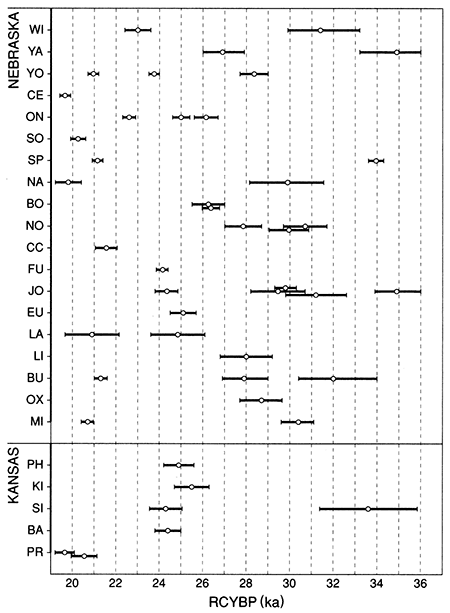
Figure 27--Localities from which radiocarbon ages have been obtained on the Gilman Canyon Formation in Nebraska and Kansas. Isolines represent total loess thickness in feet. See table 3 for site names and age data.
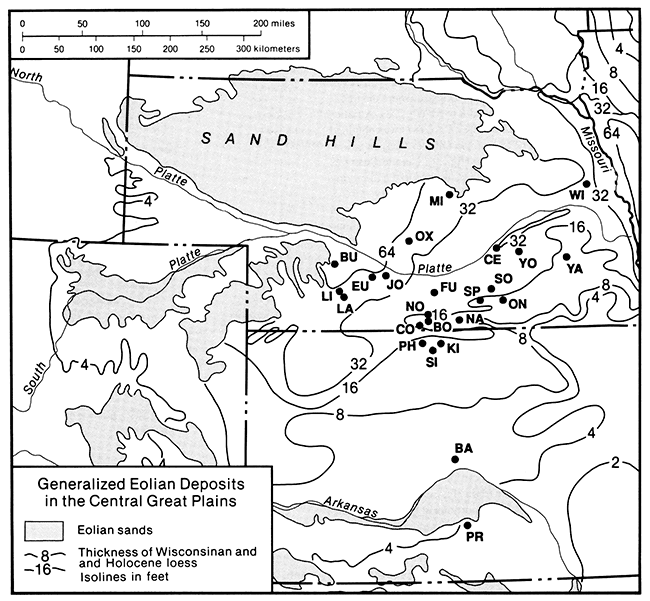
Given the radiocarbon time control and stratigraphic information currently available for the Gilman Canyon Formation in Kansas and Nebraska, it is clear that the associated soil is a geosol, that is, a laterally traceable, mappable, pedostratigraphic unit with a consistent time-stratigraphic position (Morrison, 1965; North American Commission on Stratigraphic Nomenclature, 1983, p. 865). The entire formation can be considered a geosol, but because of the possible existence of two or more identifiable cumulic A horizons merged or welded together, the Gilman Canyon may ultimately be designated a composite geosol.
The Gilman Canyon Formation is a ubiquitous feature in exposures of loess in Phillips County. It is pronounced in vertical faces and where unimproved roads bevel its surface, such as along the east-west section line road near SE SE sec. 4, T. 1 S., R. 20 W. Observed thicknesses of the Gilman Canyon within Phillips County range from 0.45 to 1.6 m (l.5-5 ft) and average approximately 1 m (3 ft). The texture is a silt loam to sandy silt loam, and the color is dark brown to purplish black. The purple cast at the Eustis ash pit appears to be derived from a relatively high iron content (S. Valastro, personal communication, 1992) but may also be due to concentrations of manganese (G. J. Retallack, personal communication, 1992). The paleotopography represented by the soil surface suggests that relief at the close of Gilman Canyon time was appreciably less than at present.
Several good exposures of the Gilman Canyon occur within cuts of the Missouri Pacific Railroad where the tracks parallel K-9 between Glade and Kirwin (fig. 28). A radiocarbon age of 25,500 ± 820 yr B.P. (Tx-6747) was obtained from the upper 5 cm (2 in.) of the Gilman Canyon. soil A horizon exposed in one of the cuts (fig. 29). The site illustrates how well the paleosol is developed, relative to the overlying surface soil. The Holdrege silt loam (a fine-silty, mixed, mesic Typic Argiustoll), considered to be a mature loessal soil, is clearly less well developed than the underlying Gilman Canyon soil; this observation has implications for the duration of soil development and landscape stability. At the Siebert gravel pit (see fig. 25) stratigraphic features (e.g., fining upward, small pebbles, lithology) indicate that the buried soil dating to Gilman Canyon time represents, at least in part, an alluvial phase rather than the eolian phase recognized elsewhere.
Figure 28--The Gilman Canyon Formation (arrow) exposed in the north face of a cut on the Missouri Pacific Railroad in NW NE NE sec. 26, T. 4 S., R. 16 W. Peoria loess overlies the formation, and the Loveland Loess and Smoky Hill Chalk Member underlie it.
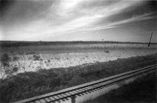
Figure 29--Soil of the Gilman Canyon Formation (spade) exposed in the south face of the railroad cut shown in fig. 28. A radiocarbon age of 25,500 ± 820 yr B.P. (Tx-6747) was obtained from the upper 5 cm (2 in.) of the buried A horizon (trowel). The clay-rich B horizon of the paleosol forms the bulge in the profile below the spade.
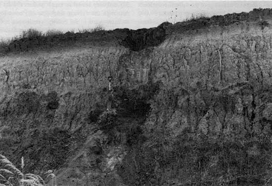
The best exposure of the Gilman Canyon Formation in an upland position is provided by a freshly excavated trench at the Phillips County sanitary landfill (fig. 30). A radiocarbon age of 24,910 ± 770 yr B.P. (Tx-6746) was obtained from a sample collected in the upper 5 cm (2 in.) of the upper organic-rich zone of the formation (fig. 31). The leached zone often recognized in the uppermost Gilman Canyon above the organic-rich portion is extremely well expressed at this locality. Furthermore, a 15-25 cm (6-10 in.) thick zone of slightly decreased organic carbon (humus) is visible under certain lighting and moisture conditions in the middle of the formation at this site, suggesting the existence of two periods of pedogenesis or an increase in loess accumulation rates during middle Gilman Canyon time. Sediment data from the formation (see fig. 24) indicate low sand (4%), high silt (89%), low clay (7%), low carbonate (leached), and high organic carbon contents. With the exception of the exposure in NW NE NE sec. 26, T. 4 S., R. 16 W. (fig. 29), the limited particle size data suggest that clay weathering or translocation was not a major pedogenic process; that is, there is no definable B or Bt horizon. Unpublished data from the Eustis ash pit document 5% or less of clay in the formation (M. M. Kerr, personal communication, 1992). Feng (1991) noted that the Gilman Canyon Formation of central Kansas is strongly weathered physically with extremely low amounts of clay.
Figure 30--The soil of the Gilman Canyon Formation exposed in the west face of a recently excavated trench at the Phillips County sanitary landfill. The pit is located in the southern half of SW SE sec. 34, T. 3 S., R. 18 W.
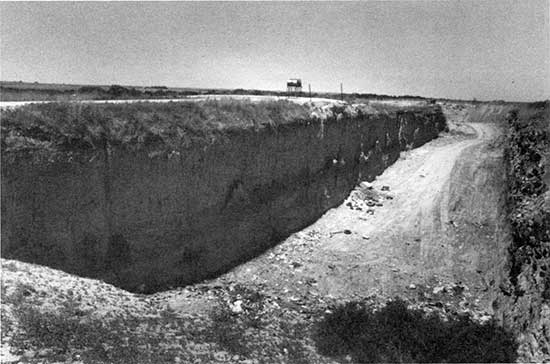
Figure 31--Soil of the Gilman Canyon Formation within the landfill trench shown in fig. 30. This photograph was taken after the trench had been partially filled. A radiocarbon age of 24,91 0 ± 770 yr B.P. (Tx-6746) was determined from a sample collected in the upper 5 cm (2 in.) of the better developed part of the A horizon (lower trowel). The profile section between the two trowels represents somewhat diminished pedogenesis because the Peoria loess fall began slowly.
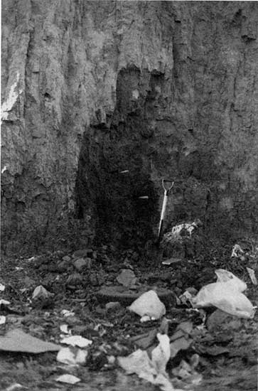
Limited paleoenvironmental data are emerging for the Gilman Canyon Formation. Potential sources of proxy data for vegetation type and hence climate are δ13C values (Krishnamurthy et al., 1982). When determinations are derived from the organic fractions of the soil, they reflect inputs by the plants, particularly grasses, growing on those surfaces. C3 (cool-season) species have an average δ13C composition of -27‰ and C4 (warm-season/arid) species -13‰ relative to the PDB standard (Deines, 1980) (table 4). The terrestrial plant ecology of the Gilman Canyon Formation apparently is characterized by primarily C4-type grasses, or a relatively warm, possibly dry climate. From plant opal phytolith morphology (Fredlund et al., 1985; Fredlund and Jaumann, 1987) and isotope data (Fredlund, 1990) it is evident that a panicoid-dominated grassland existed, that is, an environment suitable for moist, temperate-adapted tall grasses. This interpretation is not inconsistent with the δ13C values because panicoid grasses are C4 types. Furthermore, some of the derived C3-level values, specifically those from the La Sena and Lime Creek sites, reflect former peaty or otherwise local wet valley bottom environments (D. W. May, personal communication, 1992) that are characterized by meso- or hygrophytic C3 plants.
Table 4--δ13C values derived from the Gilman Canyon Formation.
| Locality | Sample | δ13C (‰) | ||
|---|---|---|---|---|
| Nebraska | ||||
| Harlan County Lake | ||||
| BO, Bone Cove | PITT-0826 | -22.4 | ||
| NO, North Cove | Tx-7073 | -15.3 | ||
| Tx-7074 | -14.3 | |||
| Tx-7072 | -17.4 | |||
| CC, Coyote Canyon | Tx-7294 | -21.3 | ||
| EU, Eustis ash pit | Tx-6633 | -16.3 | ||
| Harry Strunk Lake | ||||
| LA, La Sena site | Tx-6707 | -21.8 | ||
| Tx-6709 | -19.2 | |||
| LI, Lime Creek site | Tx-6774 | -26.4 | ||
| Kansas | ||||
| Phillips County | ||||
| PH, landfill | Tx-6746 | -16.9 | ||
| KI, Kirwin railroad cut | Tx-6747 | -14.7 | ||
| SI, Siebert gravel pit | Tx-6624 | -14.4 | ||
| Tx-6625 | -14.4 | |||
| PR, Pratt County landfill | Tx-6449 | -14.5 | ||
| Tx-6622 | -14.5 | |||
| Range | -14.4 to -26.4 | |||
| Mean | -17.6 | |||
| Mode | -14.4 | |||
A fossil pollen assemblage from a core extracted from Cheyenne Bottoms, a large marsh in central Kansas, indicates mesic conditions in the marsh and an upland vegetation of grass and sage with scattered trees in the valley and along escarpments during the period from approximately 30 ka to 25 ka (Fredlund, 1991). The Farmdalian-Woodfordian transition, approximately 25-24 ka, was characterized by increased aridity. The Muscotah Marsh fossil pollen record of northeastern Kansas reflects a mosaic of deciduous forest and prairie (Gruger, 1973; Fredlund and Jaurnann, 1987). Regionally, the Farmdalian grasslands apparently spread as far east as Iowa (Baker and Wain, 1985) and as far north as the Sand Hills region of Nebraska (Fredlund and Jaurnann, 1987).
Peoria loess Leverett (1899) first proposed the name Peoria for an interglacial period between the Iowan and Wisconsin glacial stages. When Alden and Leighton (1917) demonstrated that the Peoria was younger than Iowan, usage shifted to that of a loess rather than a weathering interval. Within the midcontinent several names have been used for post-Farmdalian loess. Ruhe (1983) preferred the term "late Wisconsin loess" because of the uncertainties in stratigraphic equivalency from one region to another. The Peoria loess is typically an eolian, calcareous, massive, light yellowish-tan to buff silt that typically overlies the Loveland Loess or an approximate equivalent of the Gilman Canyon Formation.
Ruhe (1983) noted three major features of late Wisconsin (peoria) loess: It thins downwind from the source area, decreases in particle size systematically away from the source area, and is strongly time transgressive at its base. The last feature is problematic and causes correlation problems. Ruhe (1969) realized a decrease in the age of the soil under the loess from 24,500 yr B.P. near the Missouri River to about 19,000 yr B.P. eastward across southwestern Iowa. A decrease from 25,000 to 21,000 yr B.P. was noted for the base of the loess along a transect in Illinois (Kleiss and Fehrenbacher, 1973). The top of the loess also seems to be time transgressive, ranging from about 12,500 yr B.P. in Illinois (McKay, 1979a) to 14,000 yr B.P. in central Iowa (Ruhe, 1969).
In Kansas the Peoria loess is a reddish, yellowish, or tan-buff homogeneous, massive, locally fossiliferous, variably calcareous coarse silt to very fine sand to medium to fine silt and clay (Frye and Leonard, 1952). Thicknesses vary from 100 ft (30.5 m) adjacent to the Missouri River valley to 2 ft (0.6 m) in discontinuous patches. Any accumulation less than about 2 ft (0.6 m) is presumed unrecognizable in the field because it has become incorporated into the existing surface soil.
The Peoria loess in Phillips County typicalJy rests conformably on the Gilman Canyon Formation and is highly variable in its distribution and thickness. Thicknesses are greatest in the northwest corner of the county on the north side of Prairie Dog Creek. Coverage is continuous except for the young alluvial fill in tributaries. Relatively thick but areally limited deposits occur on the sharply defined divide between the north-flowing tributaries of Prairie Dog Creek and the south-flowing tributaries of Deer Creek. Erosion since loess deposition ceased has been extensive in these high-energy tributaries. Roadcut exposures are common in this area (fig. 32) and may reveal as much as 6 m (18 ft) of the Peoria. Although the average thickness of Peoria loess decreases southeastward in the county, continuous upland coverage appears in the low-gradient tributaries flowing south into Deer Creek. With the exception of the interfluve between Deer Creek and the North Fork Solomon River, deposits in the southern third of the county are relatively small and limited to divides.
Figure 32-Peoria loess in a west-facing roadcut approximately 3 mi (5 km) south of Long Island in NW NW sec. 12, T. 2 S., R. 20 W. Loess, 5.2 m (17 ft) thick, is exposed, but total thickness is unknown.
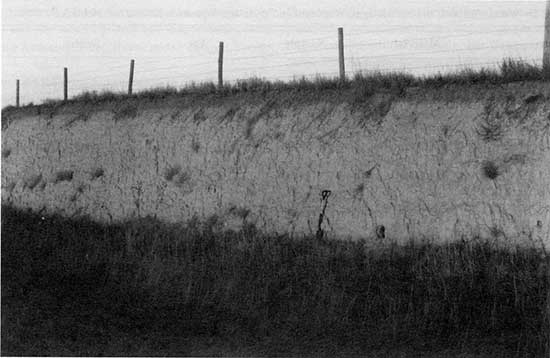
Despite the amount of attention given to the Peoria loess in Kansas, the source of the silt is not completely certain. From their review of the available data, Welch and Hale (1987) concluded that a single source was not likely for all loess deposits in Kansas and that the loess was derived from a combination of three sources: glacial outwash river floodplains, present sand dune areas, and fluvial and eolian erosion of the Ogallala Formation. The Peoria loess exposed in the Phillips County sanitary landfill contains moderate but variable amounts of sand and exhibits a general increase in clay upward. If this trend is real, it could be attributable to an influx of clay from the southwest as atmospheric wind patterns changed in response to a diminishing Laurentide ice sheet (COHMAP members, 1988).
A. B. Leonard (1952) subdivided the Peoria loess of Kansas into four zones on the basis of the molluskan fauna assemblages present. The basal zone is equivalent to the leached interval above the Gilman Canyon Formation and is void of molluskan material. The lower molluskan zone, or Iowan, produced an assemblage containing 14 species, 2 of which are diagnostic of the zone. A transitional zone, located between the upper and lower faunal zones, contains elements of both assemblages and does not imply any abrupt change in the depositional environment, although the depositional rate may have slowed somewhat. The upper molluskan zone, or Tazewellian, contains 26 species, 14 of which do not occur in the lower zone. Because of the relative youth of the Peoria, little of the upper zone has been lost from the upland. Consequently, the upper zone is frequently exposed, and many localities in Phillips County yield snail assemblages indicative of the upper zone. One of several excellent snail-rich localities is a 2-m-deep (6.6-ft-deep) roadcut located on the road between secs. 2 and 3, T. 1 S., R. 20 W.
Although readily visible stratigraphic breaks, such as the Jules soil recognized in Illinois (Frye and Willman, 1973; Frye et al., 1974; Ruhe, 1976; McKay, 1979a,b) and the soil zones in Iowa (Daniels et al., 1960; Ruhe et al., 1971), have not been identified yet in Kansas and adjacent Nebraska, evidence of one or more stable or vegetated surfaces is common. The only indication of soil development recognized is that of a Bt horizon in the Medicine Creek valley (May and Holen, 1993); interestingly, the soil has a probable Paleo-Indian association (May, 1991b). The most common line of evidence for a discontinuity in Peoria loess deposition is that of plant remains, usually cropping out as lenses. Many of the age determinations were made from Picea remains (table 5), indicating a cool, moist environment. Although radiocarbon data document the burial of vegetative material throughout the Woodfordian, two temporal clusters or modes of ages appear from the limited data: 18-17 ka and 14-13 ka. The 18-17-ka time interval represents the last glacial maximum and the 14-13 ka interval represents the time of major deglaciation (Ruddiman, 1987). By interpreting ice-core data from Greenland, Paterson and Hammer (1987) recorded a dramatic decrease in atmospheric dust content from about 13 ka; this period of reduced atmospheric dust may relate to the time of relative surface stability and tree establishment. Regional geomorphic data also support the existence of a depositional hiatus at this time. May (1989) identified deposition of the Todd Valley Formation in the South Loup River of central Nebraska at about 14 ka; the Todd Valley was subsequently buried by loess. Furthermore, Martin (1990) identified entrenchment in the Republican River of southcentral Nebraska at about 13 ka, after which valleys were filled with late Peoria loess.
Table 5--Wood, charcoal, and humate ages, Woodfordian/Peoria-age deposits in Kansas and Nebraskaa
| Location | Material | Sample | Age | Source |
|---|---|---|---|---|
| Kansas | ||||
| Superior Sand Co., Sedgwick County |
peat | Dic-310l | 19,340 ± 200/210 | Jaumann, 1991 |
| Mt. Hope Sand Co., Reno County |
Picea Litter | Beta-17900 | 16,420 ± 190 | Jaumann, 1991 |
| GMD5 site 1, Edwards County |
soil humates | Tx-6742 | 13,670 ± 290 | Johnson, 1991a |
| GMD5 site 9, Reno County |
Picea charcoal | Tx-6479 | 17,970 ± 330 | Johnson, 1991a |
| Coon Creek, Graham County |
Picea charcoal | GX-9355G | 17,930 ± 550 | Wells and Stewart, 1987 |
| Courtland Canal, Jewell County |
Picea charcoal | Beta-9320 | 14,450 ± 140 | Wells and Stewart, 1987 |
| Nebraska | ||||
| Coyote Canyon, Harlan County |
charcoal | Tx-7295 | 19,730 ± 300 | Martin, unpub. data, 1992 |
| charcoal | Tx-7293 | 21,250 ± 530 | ||
| North Cove, 25HNl64, Harlan County |
Picea glauca | Beta-12286 | 14,700 ± 100 | Wells and Stewart, 1987 |
| Naponee, Franklin County |
charcoal | Beta-33579 | 17,880 ± 170 | Souders and Kuzila, 1990 |
| Bloomington, Franklin County |
Picea or Larix charcoal |
Beta-42015 | 18,830 ± 180 | May and Holen, 1993 |
| La Sena site, 25FTI77, Frontier County |
humates | Tx-7006 | 18,860 ± 360 | May and Holen, 1993 |
| humates | Tx-6708 | 16,730 ± 490 | ||
| South Loup River, Buffalo and Grant counties |
Abies balsamea fragments |
Tx-6128 | 14,080 ± 190 | May, 1989 |
| Beta-27758 | 13,160 ± 450 | Swinehart, 1990 | ||
| a. Ages indicate surface stability or discontinuities in Peoria loess deposition. | ||||
Late Wisconsin fluvial deposits It is becoming increasingly apparent that entrenchment occurred in channels of the Kansas River basin sometime during the late Wisconsin Stage. A basal soil buried within the fill of both tributary and major stream valleys of the Kansas River basin has an age of 10,500-10,000 yr B.P. (W. C. Johnson and Martin, 1987; W. C. Johnson, 1987; W. C. Johnson and Logan, 1990), thereby providing a minimum age on the preceding entrenchment. As noted, May (1989) has radiocarbon-dated the Todd Valley fluvial sand of Nebraska to about 14,000 yr B.P.; Condra et al. (1950) had postulated a much earlier Wisconsin age. Martin (1990) recognized a late Wisconsin fill in the Republican River valley that was largely removed through entrenchment about 13,000 yr B.P. A radiocarbon age of 14,700 yr B.P. was obtained on spruce wood situated a few centimeters above crossbedded fluvial sand and gravel (Wells and Stewart, 1987; W. C. Johnson, 1989). The depth of entrenchment relative to that of the early Wisconsin fill is unknown, but A. R. Leonard (1952, p. 51) estimates a depth of 30-60 ft (9.1-18 m) below the Crete channel. Subsequent alluviation continued, at least in the larger stream systems, into the late Holocene until the surface elevation was equivalent to that of the late Wisconsin terrace. This sequence is well illustrated within fill of the Kirwin terrace. At the Siebert gravel pit, excavated within the Kirwin terrace fill (see fig. 25), the exposed sequence includes early to middle Wisconsin alluvium, the Gilman Canyon Formation, and a cap of Peoria loess, but the terrace can be physically traced downstream to the Kirwin area, where the exposed upper few meters are of late Holocene age. Despite the absence of any visible scarp, the Kirwin terrace is actually a terrace complex with different aged fills. This is an area in need of much additional research because it is only assumed that late Wisconsin alluvial fill underlies the late Holocene fill; that is, no excavation or drilling has been done to confirm or deny the stratigraphic relationships.
Quaternary System--Holocene Series
At present, the Kansas Geological Survey recognizes the Recent Stage of the Pleistocene Series (Bayne and O'Connor, 1968). As accepted by the Kansas Geological Survey, the Recent is defined as the last 5,000 years, or the time since the end of the Valderan Substage of the Wisconsin Stage. This nomenclature, awkward and regional in nature, has been largely replaced by the use of the term "Holocene" (series status). As the resolution and breadth of absolute chronologies for the late Quaternary of Kansas and adjacent areas have improved, it has become increasingly clear that use of "Recent Stage" be abandoned and that "Holocene" be adopted, as was done by the U.S. Geological Survey (Cohee, 1968).
The beginning of the Holocene, about 10 ka (Hopkins, 1975), is a time of dramatic environmental change and attendant stratigraphic discontinuities. In general, this boundary is considered only geochronometric, that is, without specific stratigraphic reference, although a stratotype in Sweden has been proposed for the boundary (Morner, 1976); the Swedish unit has a reported age of 10,000 ± 250 yr B.P. (Fairbridge, 1983). Watson and Wright (1980) contended that a major climatic and environmental change at 10 ka can be documented only on a local scale; that is, all changes recorded in the stratigraphic record are diachronous. This notion now seems to be faulty on the regional and subcontinental scale in that research of the last several years [e.g., W. C. Johnson and Martin (1987), W. C. Johnson and Logan (1990), and W. C. Johnson and May (1992)] has documented major pedogenesis at 10 ka in both alluvial and eolian/upland settings. This is the first major geosol to occur in the stratigraphic record of the region since the Gilman Canyon geosol 10,000 years earlier.
Brady soil The Brady soil was first named and described by Schultz and Stout (1948) at the Bignell Hill type locality, an eolian sequence exposed along a roadcut in the south valley wall of the Platte River of western Nebraska. The soil is developed within the Peoria loess and is overlain by the Bignell Loess. The name was subsequently adopted by researchers in Kansas (Frye and Fent, 1947; Frye and A. B. Leonard, 1949, 1951; Frye et al., 1949). The Brady soil is regionally extensive only in the northwestern and westcentral parts of Kansas, and even there it occurs discontinuously. Frye and Leonard (1951) and Caspall (1970, 1972) recognized Brady development in the northeastern and other parts of Kansas. Without the overlying Bignell Loess the Brady soil does not exist; the modern surface soil has incorporated post-Bradyan loess fall into its profile. The Brady soil is typically dark gray to gray-brown and better developed than the overlying surface soil within the Bignell. Strong textural B horizon development and carbonate accumulation in the C horizon are typical, although the soil occasionally displays evidence of having formed under poorer drainage conditions than the associated surface soils (Frye and Leonard, 1951). Feng (1991) noted that the Brady soil, as expressed in Barton County, is strongly weathered both physically and chemically.
Only two exposures of the Brady soil have been found in Phillips County; they are located in west-facing roadcuts in SWSW sec. 24, T. 4 S., R. 19 W., and NE SE sec. 26, T. 2 S., R. 20 W. The former locality was recognized by A. R. Leonard (1952, p. 42-43) and revisited in this study. It is the east face of a roadcut, 0.8 km (0.5 mi) north of Speed in which the Peoria loess, the Brady soil, and the Bignell Loess are visible (fig. 33). In the late 1940's and early 1950's the Loveland Loess, Sangamon soil, and Gilman Canyon Formation were also exposed in the roadcut; they can still be distinguished in a poor-quality exposure on the north face at the end of the roadcut. A profile within the roadcut was excavated and sampled for radiocarbon dating in the uppermost and lowermost 5 cm (2 in.) of the A horizon; ages of 8,850 ± 140 yr B.P. (Tx-6626) and 10,050 ± 160 yr B.P. (Tx-6627) were obtained, respectively (W. C. Johnson, 1990) (fig. 34). The results indicate a soil-forming interval that lasted a minimum of 1,200 radiocarbon years; my research elsewhere in the central Great Plains suggests an interval of 1,500-2,000 years.
Figure 33--Peoria loess, the Brady soil, and Bignell Loess exposed in the east face of a road cut 0.8 km (0.5 mi) north of Speed in SW SW SW sec. 24, T. 4 S., R. 19 W. The lighter Peoria loess is on the left (north) and the Brady soil (lower part of spade) with overlying Bignell Loess is on the right. The modern surface soil is buried by 30-60 cm (1-2 ft) of road construction fill. The Bignell Loess is here set into a depression, or sag, in the surface of the Peoria on the south (downwind) side of the tributary valley.
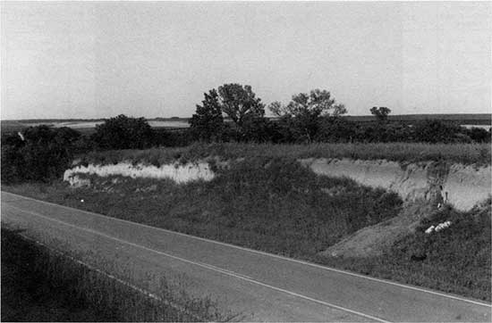
Figure 34--Profile of the Brady soil and overlying Bignell Loess in the roadcut of fig. 33. The top of the Brady soil is at the trowel point. Radiocarbon ages of 10,050 ± 160 yr B.P. (Tx-6627) and 8,850 ± 140 yr B.P. (Tx-6626) were determined from the lower and upper 5 cm (2 in.) of the Brady A horizon, respectively.
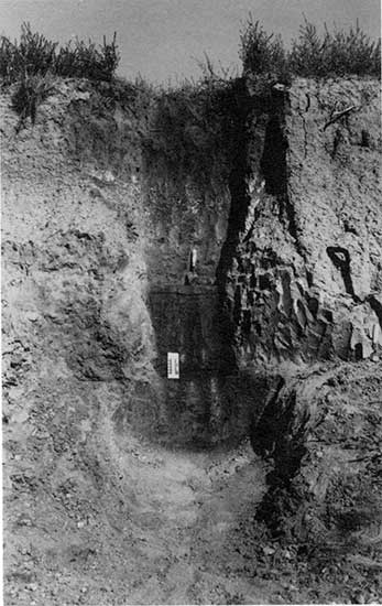
The age of the Brady soil was uncertain, even at the type locality. Dreeszen (1970, p. 19) reported an age of 9,160 ± 250 yr B.P. (W-234) obtained in 1954 and another in 1965 of 9,750 ± 300 yr B.P. (W-1676), both from the type section but likely contaminated by modern plant roots. Subsequently, Lutenegger (1985) reported an age of 8,080 ± 180 yr B.P. but provided few specifics other than that the source was the A horizon of the Brady soil at the type section. I recently secured better age control for the type section: Ages of 9,240 ± 110 yr B.P. (Tx-7425) and 10,670 ± 130 yr B.P. (Tx-7358) were obtained on the upper and lower 5 cm (2 in.), respectively, of the Brady A horizon.
The Brady soil has been dated recently at localities in Nebraska and Kansas. Souders and Kuzila (1990) obtained a radiocarbon age of 10,130 ± 140 yr B.P. for Brady soil occurring in the Republican River valley of south-central Nebraska. Sites along Harlan County Lake upstream from Naponee have yielded a number of ages, ranging from 10,550 ± 160 yr B.P. to 9,020 ± 95 yr B.P., for exposures of the Brady soil (Cornwell, 1987; W. C. Johnson, 1989; Martin, 1990; W. C. Johnson and May, 1992; C. W. Martin and W. C. Johnson, unpublished data, 1992). Two radiocarbon ages of 9,820 ± 110 yr B.P. (Tx-7045) and 10,550 ± 150 yr B.P. (Tx- 7046) have been obtained from the upper and lower 5 cm (2 in.), respectively, of the Brady A horizon exposed in Barton County, central Kansas (Feng, 1991). The two radiocarbon ages from the Speed roadcut in Phillips County agree reasonably well with those from the type section in adjacent Nebraska and central Kansas (table 6; fig. 35).
Figure 35--Graphic representation of the radiocarbon ages presently available from the Brady soil of Kansas and Nebraska.
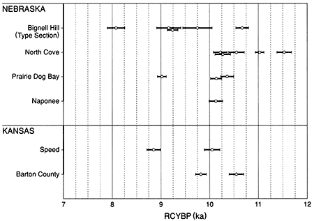
Table 6--Brady Soil Radiocarbon Ages. [Ages represent the eolian phase only. An all uvial phase has been well documented throughout the Kansas River basin (Johnson and Martin, 1987; Johnson and Logan, 1990) and adjacent river systems, such as the Loup River of central Nebraska (Brice, 1964; May, 1990) and the Pawnee River (Mandel, 1991) and Walnut River (Mandel, 1991) of the Arkansas River system.]
| Sample | Age | Source | |||
|---|---|---|---|---|---|
| Nebraska | |||||
| Bignell Hill (type section) | |||||
| n.a. | 8,080 ± 180 | Lutenegger, 1985 | |||
| W-234 | 9,160 ± 250 | Dreezen, 1970 | |||
| W-1676 | 9,750 ± 300 | Dreezen, 1970 | |||
| Tx-7425 | 9,240 ± 110 | W. C. Johnson, unpub. data, 1991 |
|||
| Tx-7358 | 10,670 ± 130 | W. C. Johnson, unpub. data, 1991 |
|||
| North Co | |||||
| west | |||||
| Tx-6319 | 10,550 ± 160 | Johnson, 1989 | |||
| Tx-6112 | 10,220 ± 140 | Johnson, 1989 | |||
| Tx-6320 | 10,270 ± 160 | Johnson, 1989 | |||
| east | |||||
| Tx-6321 | 11,530 ± 150 | Johnson, 1989 | |||
| PITT-824 | 11,025 ± 90 | C. W. Martin and Johnson, unpub. data, 1992 |
|||
| Prairie Dog Bay | |||||
| Dic-3310 | 10,140 + 110, -120 | Com well, 1987 | |||
| Tx-5909 | 10,360 ± 130 | Martin, 1990 | |||
| PITT-825 | 9,020 ± 95 | C. W. Martin and Johnson, unpub. data, 1992 |
|||
| Naponee | |||||
| Beta-33939 | 10,130 ± 140 | Souders and Kuzila, 1990 | |||
| Kansas | |||||
| Speed | |||||
| Tx-6626 | 8,850 ± 140 | Johnson, 1990 | |||
| Tx-6627 | 10,050 ± 160 | Johnson, 1990 | |||
| Barton County | |||||
| Tx-7045 | 9,820 ± 110 | Feng, 1991 | |||
| Tx-7046 | 10,550 ± 150 | Feng, 1991 | |||
There is an isochronous alluvial soil found throughout the region that is particularly well expressed in the Kansas River basin (W. C. Johnson and Martin, 1987; W. C. Johnson and Logan, 1990). The two ages of 8,274 ± 500 yr B.P. (C-108a) and 9,880 ± 670 yr a.r. (C-471) determined from alluvial fill (Fill 2A) at archeological sites Ft-50 and Ft-41 on Harry Strunk Lake in southwestern Nebraska (Schultz et al., 1951; Libby, 1955) were the first radiocarbon determinations on the Brady soil. The soil, occurring in both eolian and alluvial contexts, qualifies as a geosol, based on present radiocarbon data (W. C. Johnson and May, 1992).
Although it appears that Brady pedogenesis occurred from about 10,500 yr B.P. to as recently as 8,500 yr B.P., greater refinement of the Brady soil chronology is necessary, but present data clearly indicate that the Brady soil was a product of a major period oflandscape stability at a time when widespread climatic shifts were occurring at the end of the Wisconsin. This was the first significant period of soil development since Gilman Canyon time and represents the climate of the early Holocene.
Development of the Brady soil correlates well with indicators of regional climatic change. The fossil pollen record at Muscotah Marsh of northeastern Kansas indicates that spruce had essentially disappeared from the region by about 10,500 yr B.P. As this decline occurred, deciduous tree species increased until about 9,000 yr B.P., the time at which grassland expansion began (Gruger, 1973). On a hemispheric scale the abrupt decrease in atmospheric dust noted in the Greenland ice core at 10,750 yr B.P. (Paterson and Hammer, 1987) reflects decreased loess deposition and possibly Brady-age pedogenesis associated with relative terrestrial stability. Further, 180 levels within the same core suggest rapid warming about 10,750 yr B.P., with the characteristic Holocene temperature regime being established at about 9,000 yr B.P. At least early and perhaps all of Brady pedogenesis coincides with an abrupt and brief cool interval correlative with the classic Younger Dryas cold interval of the North Atlantic region, lasting from about 11,000 to 10,000 yr B.P. [e.g., Mott et al. (1986), Wright (1989), and Mathewes et al. (1993)].
Bignell Loess The Bignell Loess was first described and named at the type locality in a bluff exposure on the south side of the Platte River valley southeast of North Platte, Nebraska (Schultz and Stout, 1945). It is typically a gray or yellow-tan massive, calcareous silt, seldom more than 1.5 m (5 ft) thick. Although the Bignell is often less compact and more friable than the underlying Peoria loess, no certain identification can be made without the presence of the Brady soil. The Bignell Loess does not form a continuous mantle on the Peoria; instead, it occurs as discontinuous deposits that are most prevalent in and thickest adjacent to modern-day valleys, particularly the south side, and often occurs in depressions on the Peoria surface. Feng (1991) speculated that the Bignell Loess of central Kansas is relatively well weathered because it was derived from a preweathered source, the Brady soil surface, perhaps eolian and alluvial phases alike. This is consistent with the earlier interpretation derived in Nebraska that the Bignell Loess is at least partially composed of reworked Peoria loess (Condra et al., 1947, p. 33).
It appears from the radiocarbon ages for the type section in Nebraska and for the Speed roadcut that the Bignell Loess is no older than about 8,000 yr B.P. Snails collected by A. B. Leonard from the lower part of the Bignell in Doniphan County, northeastern Kansas, produced ages of 12,500 ± 400 yr B.P. (W-231) and 12,700 ± 300 yr B.P. (W-233) (Frye and Leonard, 1965). Because the shell material had absorbed an indeterminate amount of dead carbonate, Frye et al. (1968) proposed an averaged age of approximately 11,000 yr B.P. Based on the age data available for the Brady soil, the soil-humate-derived ages are probably closest to reality.
A pronounced feature of the Holocene climate of the Plains was an extended warm, dry period (Wright, 1970; Benedict and Olson, 1978; Barry, 1983), identified as the Altithermal (Antevs, 1955) or, less commonly, as the Hypsithermal interval (Deevey and Flint, 1957). This dictates that the Bignell was a warm-climate loess, unlike the cold-climate loess of the Woodfordian. Reconstruction of the general circulation patterns for North America indicates that from the last glacial maximum, about 18-15 ka, there was no detectable change in atmospheric circulation; the westerly jet was split by the Laurentide ice sheet into a north and a south flow around a strong glacial anticyclone (Kutzbach, 1985, 1987; COHMAP members, 1988). By 9 ka the ice had wasted appreciably, the jet was no longer split, orbital parameters were favoring increased temperatures, and zonal flow was dominating (Kutzbach, 1981, 1985, 1987). Model results produced mean summer temperatures 2° to 4° C higher than (COHMAP members, 1988) and annual precipitation up to 25% less than at present in the region (Bartlein et al., 1984; Kutzbach, 1987).
Because of the increasing zonal flow and aridity of the Altithermal interval, species of the tall grass community migrated eastward to the present areas of mixed deciduousprairie vegetation; that is, the prairie-forest ecozone shifted eastward (Van Zant, 1979; Semken, 1983; Webb et al., 1983). The fossil pollen record from Muscotah Marsh provides a disrupted but interpretable Holocene signal, indicating a middle Holocene prairie expansion (Gruger, 1973). Fossil pollen data from Cheyenne Bottoms suggest consistently lower water levels in the marsh during the middle Holocene (Fredlund, 1991). Molluskan faunas from the Bignell Loess of Kansas suggest that the climate was somewhat drier than during Peoria time (Frye and Leonard, 1951). After a period of soil formation near the end of the Pleistocene, pedogenesis is not recognized until about 5,800 yr B.P. in the sand of the Great Bend Prairie, central Kansas (W. C. Johnson, 1991a). Therefore, based on various climatic proxies and a limited number of radiocarbon ages, it appears that the Bignell Loess was deposited for the most part from the end of Brady pedogenesis, about 9,000 or 8,500 yr a.r. to about 5,500 yr B.P.
Fluvial deposits Holocene fluvial deposits are found in two topographic positions: (1) as a component of the Kirwin terrace fill (overlying late Wisconsin basal fill) and (2) in the bottomland area below the high-terrace level (e.g., Kirwin, Almena). Figure 36 shows both surfaces south of Kirwin; the first and older Holocene alluvium is well exposed throughout the Solomon River and Prairie Dog Creek valleys. In addition to the many natural exposures, several have been created by the excavation of trench silos into the terrace scarp. Two such silos, located south of Kirwin in SW NW sec. 34, T. 4 S., R. 16 W., expose the upper 5 m (16 ft) of the Kirwin terrace fill (fig. 37). A soil buried at a depth of 2 m (7 ft) with a simple A/C horizonation (Entisol) is well expressed in both silos (fig. 38). The upper 5 cm (2 in.) of the A horizon was sampled for radiocarbon dating; an age of 2,880 ± 70 yr B.P. (Tx-6748) indicates that the surface was buried shortly after that time because of an increase in the magnitude and/or frequency of sediment-laden overbank flows. After a short period of stability, the Solomon River then downcut to somewhere near its present level. This occurred after about 2,800 yr B.P., probably later because of the time involved in aggradation and subsequent surface soil development. Immediately north of K-9 at Kirwin where Deer Creek has cut into the Kirwin fill, three or more weakly developed soils are visible above the basal gravels in a high cutbank. May (l991a) has documented Holocene-age fill underlying the Kirwin terrace in the South Fork Solomon River downstream at Lake Waconda.
Figure 36--Scarp separating the Kirwin terrace from a lower terrace or the floodplain of the North Fork Solomon River 0.4 km (0.25 mi) south of Kirwin in SW NW sec. 34, T. 4 S., R. 16W.
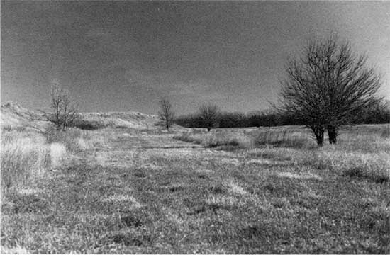
Figure 37--Face of the Kirwin terrace scarp with two trench silos excavated into it. The view is north from the low terrace or floodplain in SW SW NW sec. 34, T. 4 S., R. 16 W. A prominent buried soil is exposed in all faces of both trenches.
Figure 38--Exposure of the soil buried within uppermost fill of the Kirwin terrace (fig. 37). This profile is from the east face of the west silo. A single radiocarbon age of 2,880 ± 70 yr B.P. (Tx-6748) was determined from the upper 5 cm (2 in.) (lower part of trowel) of the buried A horizon. The soil surface was presumed buried shortly after that time.
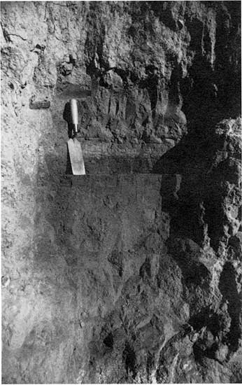
Excellent cutbank exposures occur throughout most of Deer Creek, revealing two or more buried soils. Radiocarbon ages of 1,890 ± 90 yr B.P. (Beta-2156) and 4,120 ± 270 yr B.P. (Beta-2156) were obtained on two soils in an exposure about 3.5 km (2.1 mi) east of Prairie View (fig. 39). Widespread entrenchment has been documented within the Kansas River basin at approximately 1,200 to 1,000 yr B.P. (W. C. Johnson and Logan, 1990). In this situation where the Holocene alluvium makes up at least the upper component of the high terrace, it was mapped as Qtk by W. C. Johnson and Arbogast (1993).
Figure 39--Exposure of the Holocene fill beneath the high terrace (Qt) in Deer Creek. The extent of entrenchment during the last 1,200 years is illustrated in this view. The site is located approximately 2.5 km (1.5 mi) east of Prairie View in the eastern half of SW SE sec. 2, T. 3 S., R. 20 W. Two buried soils are visible in the section (arrows).
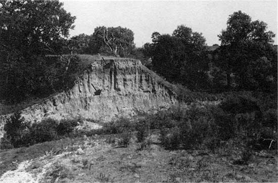
The second, more youthful type of fluvial deposit, or landform, is the recently active floodplain area created by downcutting. The relatively recent age of this activity is evidenced by the narrow nature of the active floodplain; in Prairie Dog Creek it is about 0.4 km (0.25 mi) wide, in Deer Creek and Bow Creek it is 0.2 km (0.13 mi) wide, and in the North Fork Solomon River it is 0.2 to 2.4 km (0.13-1.5 mi) wide. The young age is also attested to by the highly articulated terrace scarp, with its narrow promontories and remnants, sometimes within active channel meanders (fig. 39) (Frye and Leonard, 1952, p. 52). Lateral channel migration will eventually remove such features and widen the floodplain. Like the Kirwin, Almena, and equivalent terraces, the floodplain is a complex of surfaces or features, such as microterraces of limited areal extent, back swamps, meander scrolls, levees, eolian dunes, and scours (fig. 40). The lack of any pronounced low terrace suggests that the channel has ceased to entrench and is now moving laterally. The map unit Qal (W. C. Johnson and Arbogast, 1993) represents this most youthful portion of the alluvium.
Figure 40--Channel way, floodplain, and low terraces of the North Fork Solomon River. All three elements are ill-defined here and throughout most of the valley in Phillips County. This is a view downstream (southeast) from the bridge south of Speed.

The episodic nature of stream-system change through time has been documented graphically by Knox (1976) and by Wendland (1982) using histograms and cumulative frequency distributions of radiocarbon ages from alluvial deposits. Paleosols and terraces are indicators of the episodic change in streams. Because they represent formerly stable surfaces, paleosols in particular are useful for identifying past periods of alluvial stability because they can be radiocarbondated. Furthermore, the extent of paleosol development, represented by A horizon thickness and organic carbon content, can be used as a crude but reasonable indicator of time of pedogenesis, that is, the duration of floodplain stability. The impact of climate on stream system behavior is considered primary by most [e.g., Brakenridge (1980), Baker (1983), Knox (1983), and Waters (1985)], although alluvial histories are complex because of additional responses in the system resulting from adjustments to internal changes (Schumm, 1973; Patton and Schumm, 1981). Episodic streamsystem change has been documented for the Kansas River basin by W. C. Johnson and Martin (1987), Martin (1990), and W. C. Johnson and Logan (1990).
Eolian sand deposits Sand deposits represent a stratigraphic equivalent of the Bignell Loess. Although likely maximized during the Altithermal interval, loess deposition undoubtedly has occurred throughout the latter part of the Holocene, but it has been sufficiently small and slow as to be incorporated into existing surface soils. Consequently, the loess is not identified as a mappable unit. Because of their obvious nature and ready mobility, eolian sand deposits are of much greater importance and are considered Holocene because most have experienced major activity during this time period, although they may have originally .developed during the Wisconsin. Significant Holocene activity has been recorded in the dune fields of eastern Colorado (Forman and Maat, 1990; Forman, Goetz et al., 1992), Nebraska (Ahlbrandt et al., 1983; Swinehart, 1990), and in the Great Bend Sand Prairie adjacent to the Arkansas River of central Kansas (W. C. Johnson, 1991a).
Sand dune tracts, mapped as Qd (W. C. Johnson and Arbogast, 1993) have developed in two different topographic situations: within meander bends of the North Fork Solomon River and on the flank of the south valley wall of the Solomon River south of Logan. Eolian dune tracts have developed in alluvial sands (point bar deposits) on a low terrace of the Solomon River (fig. 41). The tracts are found along the entire length of the river valley in Phillips County and have a local relief of 8 m (26 ft) or more. The stratigraphy of one tract (SE sec. 29, T. 4 S., R. 17 W.) is presently exposed as a result of sand extraction by the B&B Sand Company of Phillipsburg (fig. 42). The deposits contain visible stratigraphic elements, such as buried soils, crossbedding, silt drapes of variable thickness, soft-sediment deformation structures, and gastropods. Detrital organic matter in the lower 5 cm (2 in.) of a 13-cm-thick (5-in.-thick) silt drape located near the base of the exposure produced a radiocarbon age of 3,920 ± 90 yr B.P. (Tx-6623) (fig. 43). The radiocarbon age on the fluvial stratum does not indicate the time of major eolian modification but rather provides a minimum age for the event. Also, it is not known whether the age is representative of all the reworked sand deposits along the river Valley. Furthermore, the radiocarbon age is problematic because it predates a soil in Kirwin terrace fill dated at 2,880 ± 70 yr B.P.; the fill is apparently stratigraphically lower and topographically higher than the silt drape.
Figure 41--North Fork Solomon River and sand dune tracts inside meander bends. The sand dunes (d) formed from eolian reworking of paleo-point bar deposits on low terraces. The B&B sand pit in one of these tracts (arrow) appears in figs. 42 and 43. The Siebert gravel pit immediately north of the sand pit exposes Wisconsin alluvial fill and the Gilman Canyon Formation. Heavily dissected Smoky Hill chalk appears along the south side of the river valley.
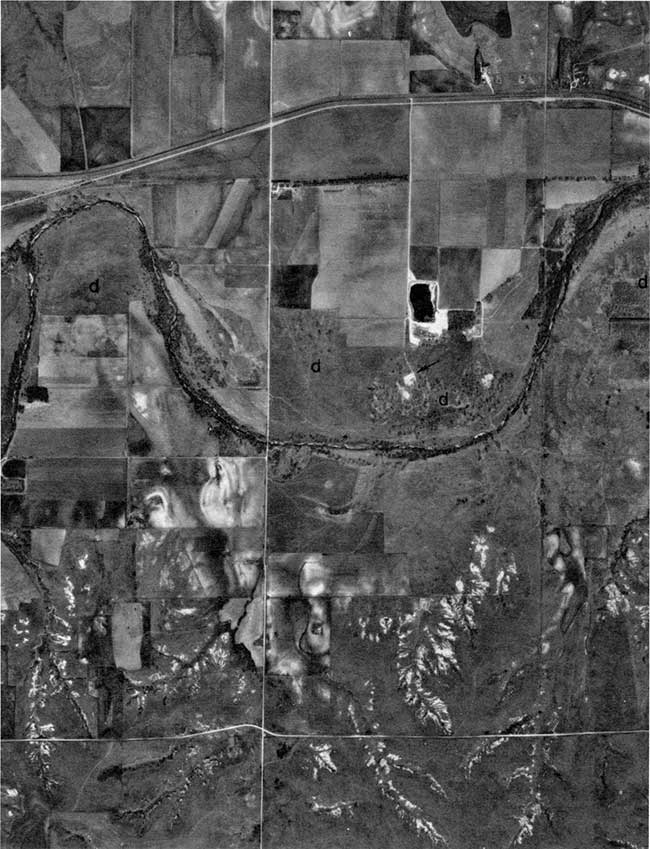
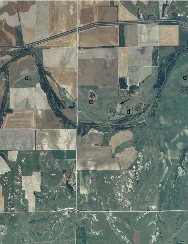
Figure 42--Sand dunes on the inside of a meander bend of the North Fork Solomon River (SE sec. 29, T. 4 S., R. 17 W.) typical of those throughout the valley in Phillips County. The sands are partially reworked alluvial sands. The profile in fig. 43 is located at the arrow.
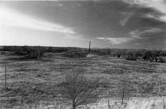
Figure 43--Profile of the dune stratigraphy revealing buried incipient A horizons, crossbedding, load flow structures, and silt drapes. The lower 5 cm (2 in.) of the silt drape at the base of the profile (arrow) yielded a radiocarbon age of 3,920 ± 90 yr B.P. (Tx-6623) on detrital carbon. Thickness of this and other meander bend sand deposits is unknown at present.
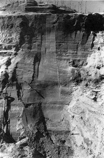
Post 3,900-yr B.P. eolian sand movement is well documented for the Sand Hills of Nebraska (Ahlbrandt et al. 1983; Swinehart, 1990); the best documented interval of eolian activity falls between 3,500 and 1,500 yr B.P. In the Great Bend Prairie of central Kansas, significant post-Altithermal sand shift occurred intermittently after about 4,800 yr B.P. CW. C. Johnson, 1991a).
A large sand dune tract exists 5 km (3 mi) south-southwest of Logan (fig. 44). It is situated on a long, broad and low, north-south-trending interfluve between two tributaries flowing north into the Solomon River. The valley of the Solomon River to the north-northwest is unusually wide, thereby providing a long wind fetch over a sandy river bottom. The sands also may have been derived in part or wholly from the Ogallala Formation, upon which the tract rests. Prevailing high-velocity northwesterly winds correspond with patterns of sand roses and dunal morphology within the region (Wells, 1983). The dune tract decreases in width and thickness and grain size toward the south, away from the river. The tract consists of tan and gray fine-grained sands and is underlain by a mortar bed of the Ogallala. No absolute age determination is available, but because the dune tract appears to be stratigraphically above the Peoria loess, it is probably Holocene in age.
Figure 44--Sand dune tract southwest of Logan in secs. 17 and 20, T. 5 S., R. 20 W. View south-southeast of the tract.
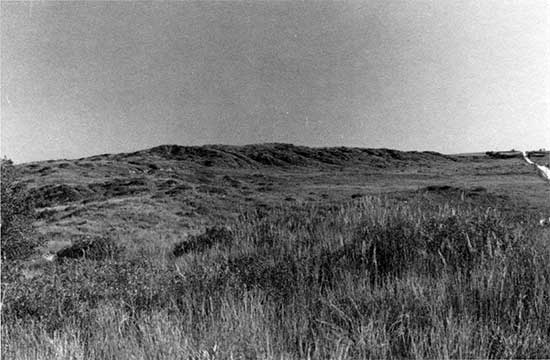
Other eolian sand deposits located in Phillips County include sand sheets on the Kirwin terrace of the Solomon River valley, particularly near Logan and Kirwin. However, these are of such limited areal extent and thickness [less than 1.8 m (6 ft)] that they are not represented on the map of the county (W. C. Johnson and Arbogast, 1993).
Prev Page--Introduction || Next Page--Recent Geologic History
Kansas Geological Survey, Geology
Placed on web Feb. 9, 2013; originally published 1993.
Comments to webadmin@kgs.ku.edu
The URL for this page is http://www.kgs.ku.edu/Publications/Bulletins/TS1/03_strat.html