![]()
Prev Page--Contents || Next Page--Stratigraphy
Introduction
Purpose and scope of the investigation
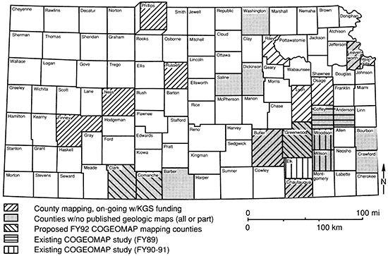
This report is an outgrowth of a county-level mapping project, one of several recently initiated for the state of Kansas, with the overall objective of generating high-resolution surficial geologic maps for each county (fig. 1). Some of the counties presently being mapped are part of the COGEOMAP (Cooperative Geologic Mapping Program-U.S. Geological Survey) project, although the Phillips County project is not one of these. The geologic map of Phillips County associated with this project (W. C. Johnson and Arbogast, 1992) is available from the Kansas Geological Survey automated cartography facility. One of the many advantages to having the map stored in this fashion is that revisions can be made by the original investigators or others as deemed appropriate, without the time and expense associated with conventional cartographic approaches. Original project field materials (e.g., maps and aerial photography) are available in the Kansas Geological Survey archives.
Figure 1--Index map of Kansas showing the location of Phillips County and the status of county-scale geologic mapping.
Geologic mapping was begun in the spring of 1989 and was completed in the early summer of 1990. The spring of 1989 was spent conducting reconnaissance mapping through remote sensing and field survey. Detailed mapping of alluvium and Cretaceous bedrock was carried out during the summer months, followed by mapping of the Tertiary Ogallala Formation and Pleistocene loess in the fall. The winter and spring of 1990 were spent addressing areas that were geologically complex or that had obscure contacts.
Location and nature of the study area
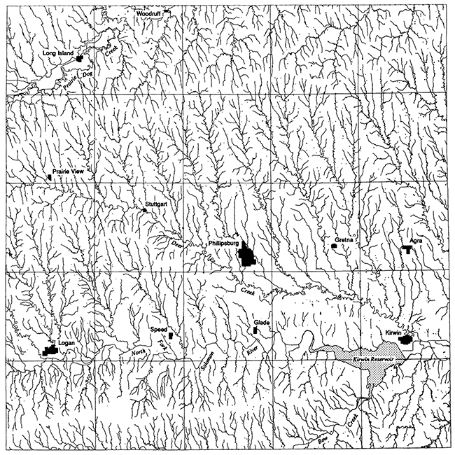
Phillips County is situated in northwestern Kansas and is bounded on the east by Smith County, on the south by Rooks County, on the west by Norton County, and on the north by Harlan County, Nebraska (fig. 1). It lies along the Smoky Hills-High Plains physiographic boundary and possesses a diverse array of landscapes because of the dissection of Cretaceous chalks and shales, Tertiary (Miocene) sands and gravels, Pleistocene eolian silts, and alluvial fill ranging in age from Pleistocene to Holocene and because of the variety of erosional unconformities separating the various units. The landscape of the county is essentially a product of the Quaternary Period (Pleistocene and Holocene epochs) from early development of the present drainage courses (fig. 2) to deposition of the loess mantle over most of the upland and valley side slopes. Much of the early benchmark research in Pleistocene stratigraphy of the state was carried out in Phillips County by John C. Frye, A. Byron Leonard, and Alvin R. Leonard during the late 1940's and early 1950's. Because of its quantitative and historical importance to surficial geology and its impact on the geomorphology of Phillips County, late Quaternary geology is emphasized in this report.
Figure 2--Drainage pattern of Phillips County.
Previous geologic investigations
Phillips County geology was studied extensively in the late 1940's and early 1950's, with the primary focus on Pliocene and Pleistocene deposits. In 1942 Landes and Keroher discussed the mineral resources, including ground water, and subsurface structure and stratigraphy. Frye and Swineford (1946) studied the silicified rocks of the Ogallala Formation, in part to determine their economic significance. Byrne et al. (1948) investigated Phillips County for sources of riprap, aggregate, and other construction materials for the Bureau of Reclamation and the State Highway Commission. Geology and ground-water resources of Norton and northwestern Phillips counties were addressed in detail by Frye and A. R. Leonard (1949). Subsequently, A. R. Leonard (1952) examined the geology and ground-water resources of the North Fork Solomon River for Phillips and three other counties downstream. Frye and A. B. Leonard (1954) examined the middle and late Pleistocene stratigraphy exposed in the cutoff trench excavated for construction of Kirwin Dam.
Other less extensive or relevant geologic studies have been carried out in the county and adjacent areas. For example, Casey and Wantland (1953) conducted preconstruction seismic investigations at the Kirwin Dam site. The subsurface geology and structure of Phillips County was investigated by Herman (1957). Metz (1954) studied the petrology of the Loveland and Peoria loesses. The invertebrate paleontology was addressed by Hanna and Johnston (1913), Hibbard et al. (1944), A. B. Leonard (1952), Frye et al. (1956), and Ho (1966). Vertebrate material was described by Osborn (1898) and Hibbard (1942).
The ground-water and surface-water hydrology of the area has received considerable attention, in part because of the Kirwin Dam project. C. R. Johnson (1956) assessed the ground-water resources of Prairie Dog Creek valley, including the valley segment in northwestern Phillips County. Stullken (1984) studied the surface-water hydrology of the same valley. Bedinger and Tanaka (1962) reported on the changes in ground-water levels attributed to Kirwin Reservoir. The hydrology of the North Fork Solomon River valley was later examined by Jorgensen and Stullken (1981). Other research not cited here bas been conducted and reported for Phillips County. A listing is available in the Bibliography of Kansas Geology, 1823-1984 (Sorensen et al., 1989, p. 386).
Methods of investigation
The geology of Phillips County was mapped primarily from stereopairs of black and white aerial photography (1:24,000) taken in January 1986 for property reappraisal, 7 1/2-minute topographic quadrangle maps, and field survey. A thickness of 1.8 m (6 ft) was considered the minimum necessary for a deposit to be defined as a mappable unit; this criterion was most applicable to alluvium, loess, and sand sheets. No deep drilling or coring was done, but shallow hand and machine augering was used to verify units below the soil zone and to ascertain thicknesses of unconsolidated deposits. Exposures were described, and measurements were taken with a hand level, tape, and pocket transit.
Soil map units from the Soil Survey of Phillips County (Palmer and Hamilton, 1987) were assessed for their correlation with lithology. As anticipated, the relationship was sufficiently poor and too variable to permit use of soil maps as a primary source for the placement of geologic contacts (table 1). It was possible, however, to use the map units of the two major soils developed in loess, the Harney and Holdrege silt loams, to approximate the location of the loess boundary, which was then refined in the field. This was particularly useful because loess presence and extent are frequently difficult to extract from aerial photographs.
Table 1--Geology and soil series associations and degree of correspondence between map units.
| Geologic unit |
Soil series |
Correspondence of soil distribution to geologya |
|---|---|---|
| Loess | Harney | good |
| Holdrege | good | |
| Penden | good | |
| Uly | good | |
| Ogallala Formation | Campus | good |
| Valentine | fair | |
| Niobrara Chalk | Brownell-Heizerb | fair |
| Wakeenb | fair | |
| Carlile Shale | Bogue | poor |
| High terrace | Anselmo | fair |
| Bridgeport | good | |
| Detroit | fair | |
| Hord | fair | |
| Low terrace and floodplain |
Inavale | fair |
| McCook | fair | |
| Munjor | fair | |
| Roxbury | fair | |
| a. Scaling: Excellent: ≤80% correspondence between geologic and soil-series map units. Good: ≥50 to <80% correspondence. Fair: <50% correspondence. Poor: geologic unit is unmappable from the soil-series map unit. b. Soil series does not distinguish between the Smoky Hill and Fort Hays Members. |
||
Alluvial deposits were mapped first because of the relative ease with which floodplains and terraces can be recognized and delimited. The Upper Cretaceous Series was mapped next, followed by the Miocene-age Ogallala Formation. The upper and lower contacts of the Ogallala were often problematic and, consequently, most time-consuming to determine. Eolian deposits were dealt with in the final phase.
Geologic contacts were first drawn on paper copies of the 7 1/2-minute, 1:24,000-scale topographic quadrangles and then transferred to planimetric Mylar base maps of the same scale for digitizing and subsequent map production through computer-aided cartography using the GIMMAP software system employed by the Kansas Geological Survey.
Prev Page--Contents || Next Page--Stratigraphy
Kansas Geological Survey, Geology
Placed on web Feb. 9, 2013; originally published 1993.
Comments to webadmin@kgs.ku.edu
The URL for this page is http://www.kgs.ku.edu/Publications/Bulletins/TS1/02_intro.html