![]()
Prev Page--Introduction || Next Page--Hydrology
Geologic Framework
Stratigraphy
A primary consideration in a geohydrologic study is the stratigraphic relation of beds that are water bearing to beds that are not water bearing (see table 1).
Table 1--GeneraLized section of geologic formations and their water-bearing properties. [Note: The classification and nomenclature of the stratigraphic units used in this report are those of the Kansas Geological Survey and differ somewhat from those of the U.S. Geological Survey.]
| System | Series | Stratigraphic unit |
Thickness, feet |
Physical character | Water supply |
|---|---|---|---|---|---|
| Quaternary | Pleistocene | Alluvium | 0-80 | Stream-laid deposits ranging from silt and clay to sand and gravel that occur along principal stream valleys. | Yields to wells range from 500 to more than 1,000 gal/minin the Arkansas River valley; 50 to 500 gal/min in the Pawnee River valley; and 50 to 1,000 gal/min in the Cimarron River valley. |
| Dune sand | 0-75 | Fine to medium quartzose sand with small amounts of clay, silt, and coarse sand formed into mounds and ridges by the wind. | Lies above the water table and does not yield water to wells. The sand has a high infiltration rate and is important as area of ground-water recharge. | ||
| Loess | 0-45 | Silt with subordinate amounts of very fine sand and clay deposited as windblown dust. | Lies above the water table and does not yield water to wells. Serves as minor area of ground-water recharge. | ||
| Undifferentiated deposits |
0-550 | Sand, gravel, silt, clay, and caliche overlie Ogallala Formation when both formations are present; composite of stream-lain and windblown deposits. | The sand and gravel of the undifferentiated Pleistocene deposits and the Ogallala Formation are the principal water-bearing deposits in the area. Yields range from 100 to 3,100 gal/min. | ||
| Tertiary | Pliocene | 0-500 | Ogallala Formation |
Poorly sorted clay, silt, sand, and gravel generally calcareous; when cemented by calcium carbonate, forms caliche layers or mortar beds. | |
| Cretaceous | Upper Cretaceous |
Niobrara Chalk |
0-250 | Upper unit (Smoky Hill Chalk Member)--ye11ow to orange-yellow chalk and 1ight- to dark-gray beds of chalky shale. Lower unit (Fort Hays Limestone Member)--consists of a white to yellow massive chalky limestone; contains thin beds of dark-gray chalky shale. | Initially (1968-72), yielded 500 to 2,500 gal/min to wells in northern Finney and eastern Kearny Counties where the Fort Hays Limestone Member has been honeycombed by fractures and solution openings. Because of increased irrigation development, yields have been reduced by 100 to as much as 2,000 gal/min. |
| Carlile Shale |
0-330 | Upper part consists of a dark-gray to blue-black noncalcareous to slightly calcareous shale that locally is interbedded with calcareous silty very fine-grained sandstone. Lower part consists of very calcareous dark-gray shale and thin gray interbedded limestone layers. | Sandstone in upper part may yield 5 to 10 gal/min to wells. | ||
| Greenhorn Limestone |
0-200 | Chalky light yellow-brown shale with thin-bedded limestone. Dark-gray calcareous shale and light- gray thin-bedded limestone; contains layers of bentonite. | Not known to yield water to wells in southwestern Kansas. | ||
| Graneros Shale |
0-130 | Dark-gray calcareous shale interbedded with black calcareous shale; contains thin beds of bentonite. Also contains thin-bedded gray limestone and fine-grained silty sandstone layers. | Not known to yield water to wells in southwestern Kansas. | ||
| Lower Cretaceous |
Undifferentiated rocks |
0-450 | Upper unit (Dakota Formation)--brown to gray fine- to medium-grained sandstone; interbedded with gray sandy shale and varicolored shale; contains lignite lenses (0-160 feet). Middle unit (Kiowa Formation)--dark-gray to black shale; interbedded with light yellow-brown and gray sandstone (0-150 feet). Lower unit (Cheyenne Sandstone)--gray and brown very fine- to medium-grained sandstone; interbedded with dark-gray shale (0-125 feet). | The sandstone units commonly yield from 50 to 500 gal/min to wells. Yields of more than 1,000 gal/min are reported in a few areas. Water may be more mineralized in the lower unit than in the upper unit. | |
| Jurassic | Upper Jurassic |
Undifferentiated rocks |
0-350 | Dark-gray shale; interbedded with grayish-green and bluish-green calcareous shale. Contains very fine- to medium-grained silty sandstone and some thin limestone beds at the base. | In Morton and Stanton Counties, sandstone beds are yielding in combination with the overlying Lower Cretaceous units. In the northernmost counties where the aquifer is deepest, the water may be mineralized. |
| Permian | Upper Permian |
Big Basin Formation |
0-160 | Brick-red to maroon siltstone and shale; contains very fine-grained sandstone. | Where not highly mineralized, may yield small quantities of usable water for domestic and stock purposes. |
| Day Creek Dolomite |
0-80 | White to pink anhydrite and gypsum; contains interbedded dark-red shale. | Solution cavities have yielded large quantities (300 to 1,000 gal/min) of high sulfate water to wells in Morton County. | ||
| Whitehorse Formation |
100-350 | Red to maroon fine-grained silty sandstone, siltstone, and shale. | Fresh to highly mineralized water. Not known to yield significant amounts of water to wells in southwestern Kansas. | ||
| Lower Permian |
Dog Creek Formation |
15-60 | Maroon silty shale, siltstone, very fine sandstone, and thin layers of dolomite and gypsum. | Not known to yield significant amounts of water to wells in south-western Kansas. Water probably highly mineralized. | |
| Baine Formation |
20-150 | Generally consists of four gypsum and anhydrite beds separated by red shale; contains bedded halite at some sites. |
The oldest beds considered in the study are those of the Lower Permian Blaine Formation, which are easily identified on geophysical logs and are usable in the interpretation of regional structure. The relation of Upper Permian rocks to the geohydrology is significant because the rocks contain highly minerali zed water. Upper Jurassic and Lower Cretaceous rocks underlying most of the area contain water-yielding zones and are in hydraulic connection with younger deposits. Upper Cretaceous rocks in the northern part of the area yield little water and retard the movement of vertical flow. Tertiary and Quaternary deposits underlie most of the area and are the principal water-yielding beds in southwestern Kansas.
Geologic Structure
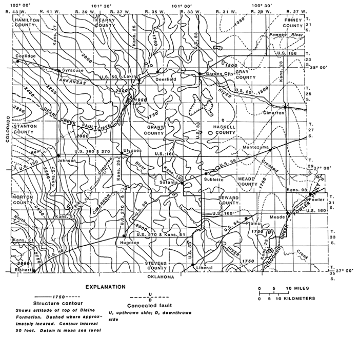
Southwestern Kansas lies in a broad marginal syncline on the east side of the Las Animas Arch (Merriam, 1963). The syncline plunges to the northeast away from the Sierra Grande uplift in southeastern Colorado. The top of the Blaine Formation, as shown by a structure map (fig. 3), slopes 14.5 feet per mile from the southwestern corner of Morton County to the north-central part of Finney County. The regional structure is cut by two faults that define the northwestern and southeastern limits of the principal aquifer in the unconsolidated deposits. These faults (the Bear Creek Fault in Hamilton, Stanton, Grant, and Kearny Counties and the Crooked Creek-Fowler Fault in Meade County), which are the result of the dissolution and removal by ground water of evaporites within and just below the Blaine Formation, have a vertical displacement of as much as 250 feet. The Crooked Creek and Fowler Faults previously have been considered separately as individual faults (Frye and Schoff, 1942). Present data indicate that the Fowler Fault and the Crooked Creek Fault are part of the same zone of dissolution and collapse. Therefore, it is recommended here that the fault be named the Crooked Creek-Fowler Fault, The Bear Creek and Crooked Creek-Fowler Faults are partially defined on the present land surface by a line of sinkholes and filled sinks.
Numerous other structural features are evi dent on the Blaine surface. A syncline in northwestern Kearny County may be traced for about 15 miles. Small, poorly defined structural features, which may be minor faults, also occur in northwestern Haskell and southwestern Finney Counties. Some of these structural features may have influenced the drainage system during erosion of the bedrock surface and subsequent deposition of the overlying unconsolidated deposits.
Figure 3--Structure contours on top of the Blaine Formation. [Larger version available as an Acrobat PDF file.]
Permian Surface
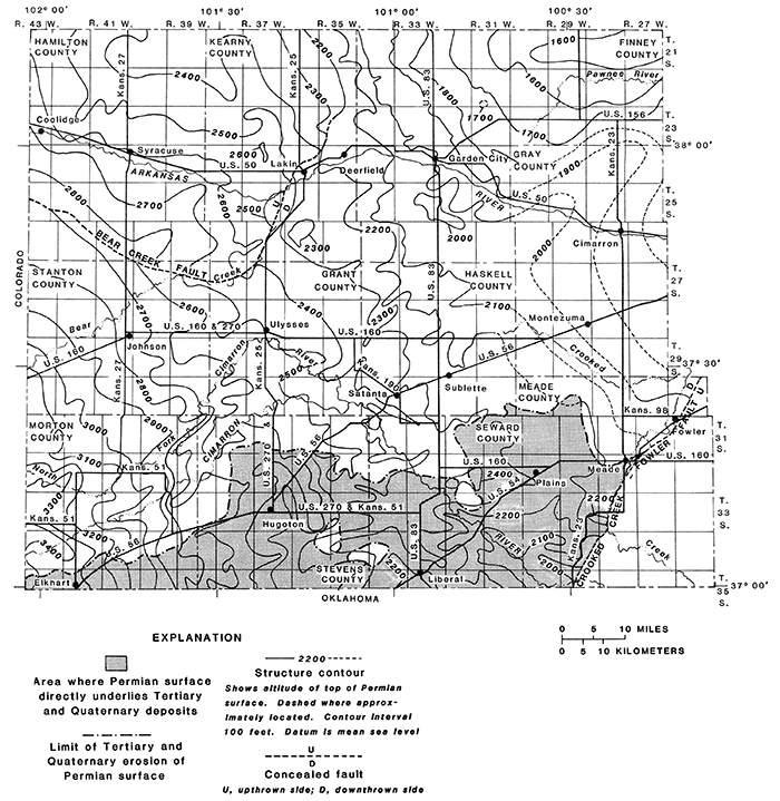
The configuration of the Permian surface (fig. 4) shows general patterns of folding, faulting, and sculpturing by post-depositional events. The general slope of the Permian surface is 15.4 feet per mile in a northeasterly direction. A period of erosion occurred prior to the deposition of the Upper Jurassic and Lower Cretaceous rocks upon the Permian surface. In parts of Haskell, Meade, Morton, Seward, and Stevens Counties, the Permian surface underwent additional erosion prior to deposition of Tertiary and Quaternary deposits. Thus, the Permian surface converges toward the top of the Blaine Formation, and the distance between these surfaces varies from slightly over 600 feet in southwestern Morton County to less than 150 feet in northeastern Finney County and south-central Meade County. The Permian surface is formed on the Whitehorse Formation, the Day Creek Dolomite, and the Big Basin Formation.
Figure 4--Configuration of top of the Permian surface. [Larger version available as an Acrobat PDF file.]
Bedrock Surface
Consolidated rocks of Late Permian to Late Cretaceous age, which underlie the unconsolidated deposits of Tertiary and Quaternary age, are referred to as bedrock in this report. The bedrock surface, as shown in plate 1, is an erosional surface influenced and modified by structure, with an average slope of 13.7 feet per mile toward the southeast. The local relief, which may be as much as 250 feet, is the result of erosion in Seward and Stevens Counties and of subsidence along the Bear Creek and Crooked Creek-Fowler Faults. In contrast, the bedrock surface in central Haskell County is nearly flat.
The bedrock surface in the southern part of the area is formed on Permian rocks and is coincident with the Pennian surface. In the central part, the bedrock surface is formed on stratigraphically younger undifferentiated rocks of Late Jurassic and Early Cretaceous age. The bedrock surface in the northern part of the study area is formed on rocks of Late Cretaceous age. The comparative altitudes of the various formations as they subcrop on this bedrock surface generally indicate a northeast dip of the bedrock units.
Surface Topography
Southwestern Kansas lies in the High Plains section of the Great Plains physiographic province (Fenneman, 1931) and is part of the broad treeless plain that slopes gently eastward from the Rocky Mountain front. In the study area, altitudes of the land surface range from about 3,850 feet in the northwestern corner of Hamilton County to 2,150 feet along the Cimarron River in the southeastern corner of Meade County. The prevailing slope on the topographic surface is about 12.5 feet per mile in a southeasterly direction.
Prev Page--Introduction || Next Page--Hydrology
Kansas Geological Survey, Geohydrology
Placed on web July 28, 2013; originally published 1981.
Comments to webadmin@kgs.ku.edu
The URL for this page is http://www.kgs.ku.edu/Publications/Bulletins/IRR7/03_gefr.html