Kansas Geological Survey, Ground-water Series 2, originally published in 1974
Rocks of Late Pennsylvanian and Early Permian age underlie Nemaha County, and are exposed along stream valleys. Glacial deposits of Pleistocene age underlie most of the county and range in thickness from a few feet to 380 feet. A deep valley that is buried by early Pleistocene deposits extends from west to east across the county. Alluvial deposits beneath the terraces and along present stream valleys are of Illinoisan to Recent age.
Wells completed in bedrock formations in Nemaha County commonly yield 50 gallons per minute or less. Yields to wells in the glacial deposits that fill the deep buried valley may be as much as 200 gallons per minute. Elsewhere in the county, the glacial deposits generally yield only enough water for relatively small domestic and stock supplies. Wells in alluvial deposits commonly yield 5 to 25 gallons per minute, but yields of as much as 150 gallons per minute are obtained locally.
Water in formations of Pennsylvanian age, in most of the glacial deposits, and in the alluvial deposits is classified as a calcium-bicarbonate type. Water in the Permian rocks and in the deeply buried glacial deposits commonly is a calcium-sulfate type. Locally, concentrations of sulfate and nitrate are as much as 2,100 and 490 milligrams per liter, respectively.
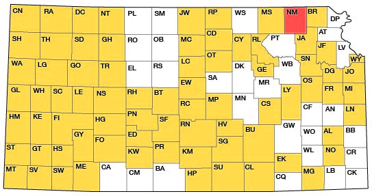
This study is part of an investigation of the geology and availability of ground water in northeastern Kansas (fig. 1). The report was prepared as part of the cooperative program between the Kansas Geological Survey and the U.S. Geological Survey with data and support by the Division of Environmental Health of the Kansas State Department of Health, and the Division of Water Resources of the Kansas State Board of Agriculture.
Figure 1--Index map of Kansas showing area described in this report and areas covered by other online geologic reports, as of Sept. 2010. For additional information, please visit the KGS Geologic Maps of Kansas Page.
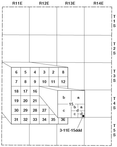
Well and test hole numbers in this report describe the location of wells and test holes according to the Bureau of Land Management's system of land subdivision as follows: first number, township; second number, range; third number, section; first letter, 160-acre tract (quarter section) within that section; second letter, 40-acre tract (quarter-quarter section) within that quarter section; third letter, 10-acre tract (quarter-quarter-quarter section) within that quarter-quarter section. The 160-acre, 40-acre, and 10-acre tracts are designated a, b, c, and d in a counterclockwise direction beginning in the northeast corner. For example, well 3-11E-15ddd is in the SE SE SE sec. 15, T. 3 S., R. 11 E. (fig.2). When two or more wells are located in the same 10-acre tract, the wells are numbered serially in the order they were inventoried.
Figure 2--Well-numbering system used in this report.
[Note: The classification and nomenclature of rock units used in this report are those of the Kansas Geological Survey and differ somewhat from those used by the U.S. Geological Survey.]
Bedrock of Late Pennsylvanian and Early Permian age underlies the county, and is exposed throughout the northern one-half of the county and along the southern county line (pl. 1). The Topeka Limestone of the Shawnee Group (see table 1), the oldest exposed formation, occurs in the channel of the South Fork Big Nemaha River in the north-central part of the county. The Wreford Limestone of the Chase Group, the youngest exposed bedrock formation, is found throughout the northeastern part of the county. Pennsylvanian and Permian rocks are exposed only along stream valley walls, except in the northeastern part of the county where erosion has removed some of the glacial cover from the uplands. Bedrock exposures along valley walls are often discontinuous as a result of erosion by buried stream valleys that extend across or along present stream valleys.
Table 1--Generalized section and water-bearing characteristics.
| System | Series | Stage | Group | Formation, or rock unit |
Thickness, in feet |
Physical characteristics | Water-bearing characteristics | |
|---|---|---|---|---|---|---|---|---|
| Quaternary | Pleistocene | Recent and Wisconsinan | Alluvium | 0-30 | Deposits of brown to bluish-gray sandy, gravelly clay. Thin beds of sand or gravel may occur at the base or within the deposit. Gravel is composed of limestone, chert, igneous, and metamorphic fragments. | Yields 5 to 25 gpm (gallons per minute) to wells, except where large thicknesses of sand and gravel yield as much as 150 gpm to wells. | ||
| Wisconsinan and Illinoisan | Terrace and valley-fill deposits | 0-50 | Discontinuous deposits of brown sandy clay on stream-valley walls or deposits of grayish-brown to gray sandy clay, fine to coarse sand and gravel beneath the floodplain. Gravel is composed of limestone, chert, igneous, and metamorphic fragments. | Yields as much as 35 gpm to wells. | ||||
| Loess | 0-15 | Wind-deposited brown to reddish-brown slightly sandy silt, generally in upland position. | Not known to yield significant quantities of water to wells. | |||||
| Kansan | Glacial Drift |
Cedar Bluffs Till | 0-100 | Heterogeneous mixture of brown, reddish-brown, yellowish-brown, or light-gray clay, silt, sand, and gravel. Erratics are common. Locally contains lenses of sand and gravel. | The clay yields little or no water to wells. Sand and gravel lenses within the till yield as much as 10 gpm, but the supply is exhaustible. The water is low in the concentration of dissolved solids. | |||
| Glacio-fluvial deposits | 0-50 | Outwash composed of fine to coarse quartz sand, silt, gravel, and boulders. Locally occurs between the Cedar Bluffs and Nickerson Tills. | Yields of 50 gpm to wells are possible everywhere in these deposits. Locally yields as much as 200 gpm. | |||||
| Nickerson Till | 0-240 | Heterogeneous mixture of dark-gray to bluish-gray with some reddish-brown clay, silt, sand, and gravel. Contains less erratics than Cedar Bluffs Till. Locally contains lenses of sand and gravel. | The clay yields little or no water to wells. Sand and gravel lenses within the till may yield 10 gpm. Water may have high sulfate concentration. | |||||
| Atchison Formation | 0-100 | Well-graded, finely cross bedded, fine to very fine silty sand. Locally becomes gray sandy silt or clay. Very thin layers of clay and gravel scattered throughout. Gravel is common at the base. Generally confined to buried valleys. | Yields 10 to 100 gpm to properly developed wells. For maximum yields, the very fine sand must be kept out of the well. Water may contain high concentrations of sulfate and iron. | |||||
| Nebraskan (?) | Fluvial deposits | 0-15 | Limestone and chert gravel derived locally from older rocks. Contains igneous material. Confined to lower part of deep buried valleys. | Yields as much as 200 gpm to properly developed wells. | ||||
| Permian | Lower Permian | Chase | Wreford Limestone | 30-40 | Upper limestone is tannish gray, medium hard, and massive with many lenses and nodules of gray chert. Intervening shale is not exposed in Nemaha County. Lower limestone is light-gray and fossiliferous with bands of chert throughout. The limestones decompose leaving only chert at weathered exposures. | May yield as much as 10 gpm to wells in limestones. | ||
| Council Grove | Speiser Shale | 15-20 | Varicolored, clayey, calcareous shale. Contains a thin persistent bed of gray, hard, fossiliferous limestone in upper part. | Not known to yield significant quantities of water to wells. | ||||
| Funston Limestone | 5-7 | Three or more layers of gray, hard, massive, dense limestone separated by beds of gray, silty, calcareous shale. | ||||||
| Blue Rapids Shale | 18-22 | Grayish-green and maroon, clayey, calcareous shale. Contains thin beds of soft, tannish-gray limestone in lower part. | ||||||
| Crouse Limestone | 10-16 | Upper limestone is tan, medium hard, and blocky to platy. Intervening shale is tannish gray, clayey, blocky, and calcareous. Lower limestone is gray, hard, massive, and fossiliferous. | ||||||
| Easly Creek Shale | 15-18 | Grayish-green and maroon, silty, calcareous shale. Contains thin calcareous beds in middle and lower parts. | ||||||
| Bader Limestone | 23-27 | Upper limestone is light gray, medium hard, massive, fossiliferous, and porous where weathered. Intervening shale is varicolored, silty, and calcareous with thin beds of gray, hard, clayey limestone, Lower limestone consists of two beds of gray, soft to hard, fossiliferous limestone separated by a tannish-gray, silty, clayey, calcareous shale. | ||||||
| Stearns Shale | 15-18 | Tannish-gray, grayish-green to purple, silty, calcareous shale. Contains thin bed of limestone near top. | ||||||
| Beattie Limestone | 10-15 | Upper limestone is gray to tannish brown, porous, and fossiliferous. Intervening shale is tannish gray, silty, thin bedded, fossiliferous, and very calcareous. Lower limestone is light gray, massive with solution channels, soft, cherty, and fossiliferous. | May yield 10 gpm to wells in solution channels and fractures in lower limestone. | |||||
| Eskridge Shale | 35-40 | Clayey, calcareous shale, tan and grayish green in upper part and maroon, purple, and grayish green in lower part. A persistent thin bed of hard, massive, fossiliferous limestone is in upper part. | Not known to yield significant quantities of water to wells. | |||||
| Grenola Limestone | 25-30 | Upper limestone composed of alternating beds of limestone and shale. Top bed is grayish brown, soft, porous limestone. Other beds are tannish-gray limestone and dark-gray shale. Shale below upper limestone is tan to gray, silty, and calcareous. Middle limestone consists of two or more beds of gray, medium-hard, massive limestone separated by tan, silty, calcareous shale. Lower shale is gray, silty, and calcareous. Lower limestone is gray to tannish gray, hard, and fossiliferous. | Yields as much as 50 gpm to wells in upper limestone. Water generally has high sulfate concentration. | |||||
| Roca Shale | 10-20 | Gray, tan, and grayish-green, clayey, blocky, calcareous shale. | Not known to yield significant quantities of water to wells. | |||||
| Red Eagle Limestone | 8-12 | Upper limestone is tannish brown, soft, clayey, and porous. Intervening shale is clayey, calcareous, blocky, and gray in upper part, but very thin bedded, dark gray, and fossiliferous in lower part. Lower limestone is gray, medium hard, massive, and fossiliferous. | May yield 10 gpm to wells in solution channels and fractures in upper limestone. Water may have high sulfate concentration. | |||||
| Johnson Shale | 15-20 | Tannish-gray to grayish-orange, silty, platy, thin-bedded, calcareous shale. | Not known to yield significant quantities of water to wells. | |||||
| Foraker Limestone | 35-45 | Upper limestone is soft, massive, dolomitic, impure, and gray to tannish gray. Intervening shale is gray, silty, fossiliferous, calcareous and contains several thin limestone beds in upper and middle parts. Lower limestone composed of an upper gray, hard, fossiliferous bed and lower gray, medium-hard, massive to shaly bed. | Yields as much as 50 gpm to wells in solution channels and fractures in upper limestone. Water generally has high sulfate concentration. | |||||
| Admire | Janesville Shale | 70-80 | Upper shale is variegated, clayey in upper part, sandy in lower part with sandstone lenses. Intervening limestone is tannish gray, medium hard, and very fossiliferous. Lower shale is tannish gray to olive drab, silty, and contains thin lenses of clayey limestone or sandy, micaceous shale. | Not known to yield significant quantities of water to wells. Locally might yield less than 5 gpm to wells in sandstone lenses. | ||||
| Falls City Limestone | 6-8 | Upper limestone is tan, medium hard, massive and is a coquina of fossil fragments. Intervening shale is tannish gray to dark gray, and clayey. Lower limestone is gray, very calcareous shale to gray, soft, fossiliferous, shaly limestone. | Not known to yield significant quantities of water to wells. | |||||
| Onaga Shale | 25-35 | Tannish-gray, grayish-green, and maroon, clayey shale at top of formation separated from tannish-gray, grayish-green, and maroon, silty, calcareous shale by a thin light-gray, medium-hard, massive, fossiliferous limestone. | ||||||
| Pennsylvanian | Upper Pennsylvanian | Wabaunsee | Wood Siding Formation | 20-30 | Three gray to grayish-brown, hard, fossiliferous limestones separated by gray to grayish-brown and maroon, silty to sandy, micaceous, calcareous shales. Upper shale contains thin, cross-bedded sandstone beds locally. | Not known to yield significant quantities of water to wells. Locally might yield less than 5 gpm to wells in sandstone beds in upper shale. | ||
| Root Shale | 40-50 | Greenish-gray to tannish-gray, clayey, sandy shale at top of formation separated from tannish-gray to bluish-gray, sandy, clayey, fossiliferous, calcareous shale by a thin gray to greenish-gray, medium-hard, fossiliferous limestone. Thin coal beds occur in upper part of both shales, and sandstone occurs locally in the lower shale. | Not known to yield significant quantities of water to wells. Locally might yield less than 5 gpm to wells in sandstone lenses. | |||||
| Stotler Limestone | 15-20 | Upper limestone is tannish brown, sandy, conglomeratic, fossiliferous, and massive. Intervening shale is gray and maroon, sandy, clayey, fossiliferous, and calcareous. Lower limestone is tannish gray, medium hard, massive, and fossiliferous. | Not known to yield significant quantities of water to wells. | |||||
| Pillsbury Shale | 20-30 | Greenish-gray and maroon clayey shale. May contain thin beds of sandy, micaceous shale or sandstone. | Not known to yield significant quantities of water to wells. Locally might yield less than 5 gpm to wells in sandstone lenses. | |||||
| Zeandale Limestone | 20-30 | Upper limestone is tannish gray, medium hard, and fossiliferous. Intervening shale is grayish brown and silty in upper part; grayish green and maroon, blocky, fossiliferous, and calcareous in lower part. Lower limestone is grayish brown, fossiliferous, hard, massive, somewhat dense in the upper part and shaly near the base. | Not known to yield significant quantities of water to wells. | |||||
| Willard Shale | 30-40 | Gray to brownish-gray, silty, sandy, micaceous shale. Upper part contains micaceous cross-bedded sandstone. | Not known to yield significant quantities of water to wells. Locally might yield less than 5 gpm to wells in sandstone lenses. | |||||
| Emporia Limestone | 10-15 | Upper limestone is bluish gray to brown, hard, and fossiliferous with thin beds of gray, clayey, calcareous shale. Intervening shale is gray to greenish gray, calcareous, and blocky. Lower limestone is three or four beds of bluish-gray to brown, slightly fossiliferous, hard, dense limestone. | Not known to yield significant quantities of water to wells. | |||||
| Auburn Shale | 15-30 | Tan to gray in upper part, tan to yellow in middle part, and greenish-gray in lower part, silty and clayey, fossiliferous shale. Contains thin limestone beds. | ||||||
| Bern Limestone | 15-25 | Consists of an upper tannish-brown, bedded, soft- to medium-hard, fossiliferous limestone separated by thin beds of shale; a middle gray to greenish-gray, silty to clayey, calcareous shale; and a lower gray to brown, bedded, soft- to medium-hard, fossiliferous, porous limestone. | Not known to yield significant quantities of water to wells. Locally might yield less than 1 gpm to wells in weathered and fractured zones near outcrop area. | |||||
| Scranton Shale | 115-135 | Consists of thick upper and lower tan, bluish-gray, greenish-gray and maroon, sandy to silty, micaceous, clayey shales separated by a 1-foot thick gray, medium-hard, fossiliferous, lenticular limestone. The shales include lime-cemented, cross-bedded, ripple- marked sandstones. The thin Elmo coal bed separates the shales where the limestone is absent. | Yields as much as 10 gpm locally to wells in sandstone lenses. | |||||
| Howard Limestone | 5-10 | Alternating beds of bluish-gray, fossiliferous, hard, dense limestones that weather to brown, and dark- gray to tannish-gray, calcareous, silty shale. Contains coal bed at base of formation. | Not known to yield significant quantities of water to wells. | |||||
| Severy Shale | 20-35 | Gray to tan, sandy shale, clayey in upper part, silty and calcareous in lower part. | ||||||
| Shawnee | Topeka Limestone | 20-30 | Nine alternating beds of bluish-gray to gray, fossiliferous, hard to medium-hard limestone that weather to brown, and bluish-gray to black, somewhat fossiliferous, calcareous, silty shale. Locally, thin coal beds occur in the shale. | Not known to yield significant quantities of water to wells. Locally might yield less than 1 gpm to wells in weathered and fractured zones near outcrop area. | ||||
The general northwestward dip of the Pennsylvanian and Permian beds in northeastern Kansas is interrupted in Nemaha County as a result of Late Permian and post-Permian movements along the Nemaha anticline. This anticlinal structure underlies the county along a line from near Bern in the north-central part to sec. 35, T. 5 S., R. 12 E. on the southern county line. As a result of the structural deformation, Permian rocks are exposed in the east-northeast and west-northwest parts of the county, whereas Pennsylvanian rocks occur in an area from the north-central to the southwest part of the county. The oldest Pennsylvanian rocks are exposed near the axis of the Nemaha anticline where the crest of the anticline has been eroded. Permian rocks are exposed along t-he flanks of the anticline. Localized deformation is exemplified near Bern where exposures of Permian beds show an eastward dip of as much as 30 degrees on the downthrown side of the fault indicated on the geologic map. This extreme eastward dip is local, however, and extends only a few miles to the east. On the west or upthrown side of the fault, Pennsylvanian beds are horizontal or dip slightly westward. This westward dip increases to 15 feet per mile in the western part of the county.
The Nemaha anticline has greatly affected the thickness of the sedimentary rocks in the county. On the west flank of the anticline, the rocks range in thickness from 600 feet near Seneca to 1,000 feet at the western county line. On the east flank of the anticline the sedimentary rocks may be as much as 4,000 feet thick within a few miles of the axis.
A map showing the configuration of the bedrock surface at the end of the Kansan Stage (fig. 3) indicates a well-developed drainage system. The deeply incised valleys are filled principally with glacial drift of Nebraskan(?) and Kansan age.
Figure 3--Configuration of bedrock surface at the end ofthe Kansan Stage.
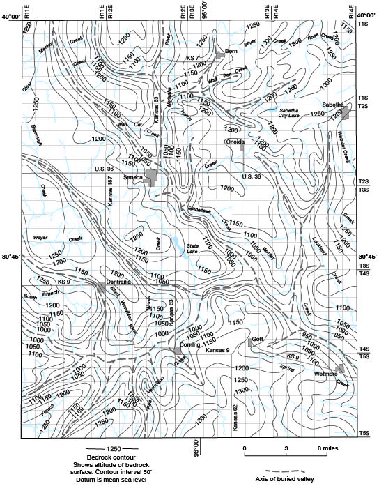
A major buried stream valley extends from about 4 miles south of Centralia eastward to the county line near Wetmore. This valley and its tributaries began developing by early Nebraskan time. Evidence from studies in surrounding counties indicates that the valley extends about 40 miles northwestward from Centralia, and extends eastward from Wetmore through Jackson and Atchison Counties in Kansas and then northeastward into Missouri. In Nemaha County, the width of the buried valley ranges from one-half to one and one-half miles and the depth is about 200 feet.
The major valley has several buried tributaries that appear to be at the same base level as the larger valley. The most significant tributary extends from its intersection with the major valley northwestward to Seneca. From Seneca the tributary extends farther north-northwest where it divides again. The northwestward extension is buried by glacial deposits and has no apparent relation to present streams. The northward extension coincides with the valleys of the South Fork Big Nemaha River and Turkey Creek, as indicated by remnants of glacial deposits along the valley walls. The present course of these two streams and their tributaries has been strongly influenced by pre-Illinoisan buried valleys. General trends and gradients of the buried tributary valleys indicate that early Pleistocene drainage was eastward. Late Pleistocene and Recent drainage flows generally southward and northward from the present topographic divide that extends across the county.
Unconsolidated glacial drift, loess, deposits beneath terraces, and alluvium overlie the bedrock surface. The known thickness of these deposits ranges from a few feet to 380 feet.
Nebraskan(?) deposits have not been identified in exposures, but deep test holes reveal basal gravels that are of pre-Kansan age. These gravels are composed largely of limestone and chert fragments, but also contain fragments of igneous and metamorphosed material that have no local source. The limestone and chert probably were derived from rocks of Permian and Cretaceous age west of this area, and were transported to their present locations by periglacial streams flowing in the now-buried channels. The igneous and metamorphosed material probably was transported by glaciers, then reworked and deposited by the periglacial streams.
The Atchison Formation is an early Kansan glaciolacustrine sand deposit that overlies the Nebraskan(?) basal gravel deposits. The formation generally is confined to the buried valleys. Test drilling indicates that the formation either is absent or grades into soft, sandy bluish-gray clay in the western part of the county. Deposition of the very fine silty sand in the Atchison Formation is believed to have preceded deposition of the Nickerson Till by an early Kansan glacial advance.
The Nickerson Till appears to have been deposited in depressions where the Atchison Formation is missing and the till often reaches great thicknesses. The heterogeneous mixture of fine- to coarse-grained material is predominantly dark gray and contains some lenses of sand and gravel. Deposition of the Nickerson Till was spread over stream channels and upland areas, but the till may not have been deposited on the highest bedrock surfaces.
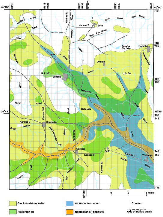
Locally, glaciofluvial deposits of fine to coarse sand, silt, and gravel separate the Nickerson Till from the overlying Cedar Bluffs Till. These glaciofluvial materials that were deposited in stream channels or depressions by meltwater from the glaciers extend over several large areas. The areal extent of the four oldest Pleistocene units is shown on figure 4.
Figure 4--Areal distribution of the four oldest Pleistocene units.
The Cedar Bluffs Till is present throughout the county except along stream valleys where it has been removed by late Pleistocene erosion. This heterogeneous mixture of fine- to course-grained material is tan, brown, or light gray, commonly contains erratics, and locally contains lenses of sand and gravel.
Stream erosion was the primary geologic process during Illinoisan time, but some materials underlying terraces along the South Fork Big Nemaha River may be remnants of Illinoisan deposition. These deposits are composed primarily of sandy clay, which is characteristic of the reworked glacial deposits. The terrace deposits are not considered significant geologic features, however, and have not been mapped as separate units on the geologic map. The present stream pattern began developing during Illinoisan time, with some streams cutting new channels into the bedrock surface and others, after removing the glacial cover, resuming flow in or near the preglacial channels.
Stream erosion and deposition increased during Wisconsinan time. Deposits of Wisconsinan age underlie terraces and flood plains in all major stream valleys, and are composed of reworked glacial material. These deposits have not been shown as separate units on the geologic map. The wind-deposited loess, primarily of Wisconsinan age, that mantles much of the uplands generally is less than 10 feet thick and is not considered to be significant enough to map as a separate unit.
Alluvium of Wisconsinan and Recent age occurs in all stream valleys in the county. It is composed primarily of reworked and redistributed clayey glacial deposits. Locally, small pockets of sand and gravel or thin layers of fine sand are present.
The relation of bedrock to unconsolidated deposits is shown on plate 2. Several of the buried valleys that are readily apparent on the profiles show the relative thicknesses of the glacial cover in various parts of the county. The positions of some of the larger areas of glaciofluvial deposits, Atchison Formation, and fluvial deposits are shown. Present stream trends can be compared with buried stream valleys.
Both the irregular relief of the land surface and the texture of the glacial deposits exert a strong influence on recharge to and discharge from the aquifers. Rainfall on uplands that are underlain by glacial till of low permeability runs off rapidly and contributes little ground-water recharge. Rainfall and storm runoff in areas underlain by glaciofluvial deposits of high permeability contribute appreciable quantities of water to the aquifer. Recharge to permeable glacial deposits also may occur by upward leakage of water under higher hydrostatic pressure from bedrock formations. Natural discharge is principally from permeable glacial deposits to streams that have eroded below the potentiometric surface of the aquifers. The quantity of water discharged in this manner is sufficient to cause most streams in the area to flow continuously, even during periods of little precipitation. Other discharge is by wells. A few artesian wells in the county flow continuously.
The location of wells, test holes, and springs in Nemaha County is shown on plate 3. Also shown are well depths, water levels, and the aquifer that yields water to each well.
Although the potentiometric surface is continuous in the alluvium of South Fork Big Nemaha River and Turkey Creek, there are not enough data to show the surface in detail. Large areas of the uplands are underlain by isolated deposits of saturated sand and gravel that are separated by great thicknesses of relatively impermeable glacial till. Water in the sand and gravel deposits may be semiconfined (semiartesian) or unconfined.
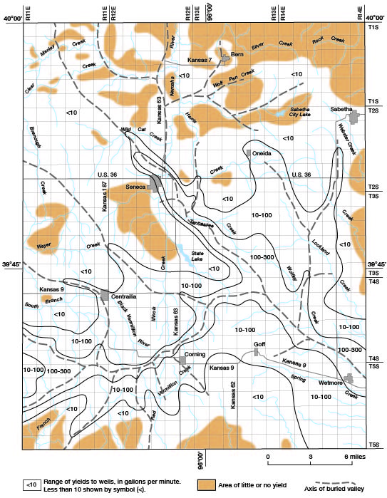
Greatest saturated thicknesses generally are in areas that are underlain by buried valleys filled with large thicknesses of glacial materials (fig. 5). Locally, however, the valleys are filled by relatively impermeable till that yields little water to wells. Often, a shallow aquifer is underlain by till of low permeability so that the effective water-producing zone is much less than the saturated thickness of glacial deposits. The unconsolidated deposits thin near valley walls and bedrock highs, resulting in less saturated thickness. In most areas where 20 to 30 feet of saturation exists, thin sand or gravel deposits should yield sufficient quantities of water for domestic and stock use. The range in yields to wells from the unconsolidated deposits (fig. 6) is related both to the saturated thickness and the permeability of the water-producing material.
Figure 5--Saturated thickness of unconsolidated deposits, 1968-72.
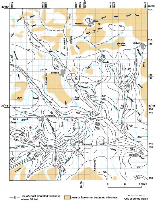
Figure 6--Generalized yields to wells in uncolidated deposits, 1968-72.
Pennsylvanian rocks generally are not aquifers in most of the county. The only Pennsylvanian formation known to yield significant quantities of water is the Scranton Shale. Permeable sandstone lenses within the Scranton near its outcrop area in the north-central part of the county may yield as much as 10 gpm (gallons per minute) to wells. Recharge to the Scranton may occur by leakage from overlying Pleistocene deposits or by infiltration of rainfall in the outcrop area.
Permian rocks contain aquifers throughout the county. The most important Permian aquifers are the Foraker Limestone and Grenola Limestone, which locally yield as much as 50 gpm to wells, and the Red Eagle Limestone, Beattie Limestone, and Wreford Limestone, which may yield as much as 10 gpm. Water occurs in the limestone members of these formations in secondary openings such as solution channels and fractures. Artesian conditions exist in most of the Permian aquifers, and a few wells flow continuously. Where water moves from the Permian aquifers into glacial deposits within buried valleys, the hydrostatic level in the glacial deposits appears to equalize with that in the bedrock formation. Recharge to the Permian aquifers occurs mainly by leakage from overlying Pleistocene deposits and by infiltration of precipitation on the outcrop areas.
The unconsolidated Pleistocene deposits are the best potential sources of ground water in the county. The most favorable areas for high-yielding wells generally overlie buried valleys. Although the glacial deposits differ both horizontally and vertically in texture, the coarsest and most permeable deposit is the Nebraskan(?) basal gravel that rests directly on bedrock. Yields from wells in this gravel are as much as 200 gpm, and specific capacities of wells are estimated to range from 15 to 20 gpm per foot of drawdown. The Atchison Formation yields as much as 100 gpm to wells locally, but specific capacity may be less than 2 gpm per foot of drawdown. Wells in this formation must be thoroughly developed so that the very fine sand does not clog the slotted pipe or well screens. Water in the Nebraskan(?) deposits and Atchison Formation is commonly under artesian pressure and at least one well flows continuously at a rate of about 5 gpm.
The sandy glaciofluvial deposits above the Nickerson Till are local in extent and generally contain water that is unconfined. Wells in the deposits commonly yield 50 gpm and locally yield as much as 200 gpm. Specific capacities generally range from 5 to 10 gpm per foot of drawdown. The wells should be thoroughly developed to prevent clogging of the intake by fine sand. Many springs issue from the glaciofluvial deposits where they are exposed along valley walls.
The Kansan tills are relatively impermeable and generally yield less than 10 gpm to wells. No significant quantity of water is available from till where it thins near present stream valleys or bedrock highs. Locally, lenses of sand and gravel are the source of water for wells completed in the till. The water in the till generally occurs under unconfined conditions. Because the sand and gravel in the till is isolated, recharge is slow and prolonged pumping may exhaust the supply.
The terrace deposits and alluvium are principally silt and clay throughout most of the county, and wells in these deposits commonly yield less than 10 gpm. Specific capacities of wells are commonly about 2 gpm per foot of drawdown. Locally, yields of 150 gpm are possible from wells in the alluvium. These larger yields are in areas where present streams have reworked coarse material that was deposited originally in the old stream channels. One such area is near Seneca in the valley of the South Fork Big Nemaha River.
Samples of water were collected for chemical analysis from 35 domestic, stock, and public-supply wells in bedrock, glacial drift, and alluvial aquifers. The analyses are given in table 2. In addition, 300 samples of water also were collected for partial chemical analysis from domestic and stock wells in the county. The partial analyses consisted of the determination of the concentration of sulfate, chloride, nitrate, and the specific conductance and pH. Using the results of the analyses, the ground water can be classified into general chemical types according to the predominant cation and anion in the water (expressed in milliequivalents per liter). Diagrams depicting water types from wells in Nemaha County are shown in figure 7. Water from wells in rocks of Pennsylvanian age and in the alluvial and glacial deposits generally is a calcium-bicarbonate type. Water from wells in most Permian rocks and the deeply buried glacial deposits is of the calcium-sulfate type.
Figure 7--Diagrams showing chemical quality of water types.
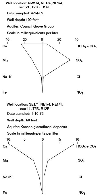
Table 2--Chemical analyses of water from selected wells. [Dissolved constituents and hardness given in milligrams per liter. Analyses by Kansas State Department of Health.]
| Well number |
Depth (feet) |
Geologic source1 |
Date of collection |
Temp. (°C) |
Dissolved solids (residue at 180°C) |
Dissolved silica (SiO2) |
Dissolved iron (Fe) |
Dissolved manganese (Mn) |
Dissolved calcium (Ca) |
Dissolved magnesium (Mg) |
Sodium and potassium (Na+K) |
Bicarbonate (HCO3) |
Dissolved sulfate (SO4) |
Dissolved chloride (Cl) |
Dissolved fluoride (F) |
Dissolved nitrate (NO3) |
Hardness3 as CO3 |
Specific conductance (micromhos/cm at 25°C) |
pH | ||
|---|---|---|---|---|---|---|---|---|---|---|---|---|---|---|---|---|---|---|---|---|---|
| Calcium, magnesium |
Carbonate | Non- carbonate |
|||||||||||||||||||
| 1-11E-17bbb | 80 | Qd | 4-14-1969 | 14.0 | 506 | 9.6 | .48 | 0.00 | 64 | 48 | 55 | 444 | 80 | 8.0 | 0.3 | 4.9 | 360 | 360 | 0 | 790 | 7.9 |
| 1-11E-35cda | 29 | Qd | 3-13-1968 | 11.5 | 530 | 24 | .00 | .00 | 77 | 22 | 89 | 508 | 22 | 9.0 | .4 | 37 | 280 | 280 | 0 | 820 | 8.1 |
| 1-12E-7aaa | 40 | Qd | 4-14-1969 | 12.0 | 818 | 28 | .06 | .00 | 160 | 37 | 65 | 461 | 160 | 35 | .4 | 100 | 540 | 370 | 170 | 1200 | 7.1 |
| 1-12E-27aaa | 25 | Pw | 4-14-1969 | 11.5 | 194 | 12 | .79 | .00 | 42 | 2.7 | 22 | 161 | 20 | 4.0 | .3 | 2.4 | 120 | 120 | 0 | 290 | 8.0 |
| 1-12E-36cdd | 29 | Qal | 3-13-1968 | 12.0 | 569 | 26 | .00 | .00 | 120 | 13 | 40 | 237 | 76 | 44 | .1 | 130 | 350 | 190 | 160 | 870 | 7.2 |
| 1-13E-16cab | 88 | Qd | 2-18-1971 | 455 | 20 | .49 | .22 | 77 | 32 | 50 | 429 | 51 | 13 | .4 | .4 | 320 | 320 | 0 | 740 | 7.3 | |
| 1-13E-19abb | 147 | Pw | 4-14-1969 | 11.5 | 988 | 15 | .43 | .10 | 130 | 57 | 101 | 444 | 92 | 58 | .2 | 290 | 570 | 370 | 200 | 1430 | 8.0 |
| 1-13E-35ccc | 40 | Qal | 1-13-1971 | 463 | 21 | .02 | .00 | 110 | 22 | 25 | 424 | 60 | 10 | .1 | .7 | 380 | 353 | 27 | 740 | 7.3 | |
| 1-14E-15bbb | 34 | Qd | 4-14-1969 | 13.5 | 460 | 13 | .91 | .00 | 110 | 16 | 22 | 312 | 46 | 6.0 | .2 | 88 | 340 | 258 | 82 | 710 | 7.8 |
| 1-14E-30dcd | 120 | Pcg, Qd | 3-13-1968 | 13.5 | 577 | 21 | .00 | .00 | 110 | 37 | 41 | 459 | 72 | 16 | .4 | 55 | 420 | 372 | 48 | 900 | 7.5 |
| 2-11E-8ccd | 99 | Qd | 4-14-1969 | 13.0 | 2180 | 26 | 4.1 | 1.0 | 400 | 120 | 86 | 361 | 1300 | 16 | .8 | 5.3 | 1500 | 300 | 1200 | 2400 | 7.1 |
| 2-12E-16bbb | 30 | Qd | 4-14-1969 | 13.5 | 480 | 22 | .05 | .05 | 110 | 22 | 38 | 473 | 46 | 10 | .3 | .2 | 360 | 360 | 0 | 740 | 7.2 |
| 2-12E-26cdd7 | 54 | Qd, Qal | 3-24-1970 | 528 | 22 | .06 | .14 | 130 | 29 | 21 | 449 | 59 | 24 | .2 | 21 | 450 | 372 | 78 | 850 | 7.2 | |
| 2-13E-21bcd | 16 | Qd | 4-14-1969 | 13.5 | 1810 | 18 | .58 | 1.4 | 300 | 100 | 110 | 381 | 1000 | 15 | .8 | 6.2 | 1200 | 350 | 850 | 2110 | 7.5 |
| 2-14E-21aab | 40 | Qd | 4-14-1969 | 13.5 | 404 | 28 | .15 | .00 | 78 | 22 | 35 | 351 | 12 | 8.0 | .4 | 53 | 280 | 280 | 0 | 640 | 7.5 |
| 2-14E-21aab2 | 102 | Pcg, Qd | 4-14-1969 | 11.0 | 2490 | 15 | 11 | .78 | 490 | 130 | 54 | 298 | 1600 | 17 | 1.0 | .4 | 1800 | 300 | 1500 | 2670 | 7.1 |
| 3-11E-15ddd | 80 | Qd | 3-12-1968 | 13.0 | 435 | 32 | .53 | .00 | 83 | 31 | 31 | 420 | 17 | 15 | .3 | 19 | 330 | 330 | 0 | 700 | 7.5 |
| 3-12E-32aba | 44 | Qd | 4-11-1969 | 6.5 | 1070 | 21 | .07 | .00 | 170 | 26 | 130 | 303 | 350 | 38 | .4 | 160 | 530 | 240 | 290 | 1450 | 7.5 |
| 3-13E-9bcc | 70 | Qd | 4-14-1969 | 12.0 | 388 | 21 | .14 | .00 | 72 | 15 | 36 | 166 | 34 | 34 | .2 | 85 | 240 | 159 | 81 | 610 | 8.4 |
| 3-13E-32ccd | 40 | Qal | 3-12-1968 | 8.5 | 704 | 17 | .03 | .14 | 170 | 35 | 27 | 459 | 110 | 55 | .2 | 62 | 560 | 370 | 190 | 1090 | 7.2 |
| 3-14E-8bba | 42 | Qd | 3-13-1968 | 7.0 | 635 | 29 | .00 | .00 | 120 | 36 | 33 | 386 | 63 | 37 | .4 | 120 | 460 | 320 | 140 | 1000 | 7.4 |
| 4-11E-11aab | 52 | Qal | 1-5-1972 | 485 | 22 | .6 | .34 | 110 | 15 | 48 | 398 | 74 | 19 | .2 | 3.8 | 330 | 328 | 2 | 760 | 7.3 | |
| 4-11E-34ccb | 50 | Qd | 3-11-1968 | 429 | 28 | .19 | .24 | 85 | 27 | 36 | 432 | 11 | 22 | .8 | 6.6 | 320 | 320 | 0 | 700 | 7.4 | |
| 4-12E-29bbb | 112 | Qd | 4-11-1969 | 14.5 | 3140 | 29 | 1.3 | .92 | 580 | 150 | 130 | 322 | 1800 | 65 | .8 | 110 | 2100 | 300 | 1800 | 3350 | 7.4 |
| 4-13E-23ccc | 40 | Qd | 4-11-1969 | 11.5 | 188 | 12 | .84 | .00 | 46 | 11 | 5.8 | 171 | 12 | 8.0 | .3 | 4.4 | 160 | 140 | 20 | 300 | 7.1 |
| 4-13E-35baa | 121 | Qd | 7-28-1971 | 1290 | 20 | 1.7 | .24 | 200 | 71 | 120 | 368 | 630 | 46 | .5 | 2.2 | 780 | 300 | 480 | 1720 | 7.3 | |
| 4-14E-9bcb2 | 35 | Qd | 3-13-1968 | 7.0 | 652 | 26 | .26 | .08 | 140 | 29 | 21 | 322 | 64 | 40 | .2 | 170 | 480 | 270 | 210 | 1020 | 7.3 |
| 5-11E-2cbb | 318 | Qd | 1-19-1972 | 494 | 36 | .17 | .05 | 72 | 24 | 84 | 449 | 54 | 10 | .2 | 16 | 280 | 280 | 0 | 800 | 7.5 | |
| 5-11E-32ddd | 54 | Qd | 4-11-1969 | 11.0 | 356 | 27 | .19 | .00 | 82 | 6.7 | 29 | 278 | 58 | 9.0 | .2 | .2 | 230 | 226 | 4 | 540 | 7.6 |
| 5-12E-11aad | 48 | Qd | 1-10-1972 | 544 | 33 | 8.2 | 1.9 | 130 | 28 | 26 | 461 | 84 | 17 | .2 | 1.1 | 430 | 374 | 56 | 820 | 6.9 | |
| 5-12E-19ccd | 20 | Qal | 3-11-1968 | 11.5 | 946 | 23 | .81 | 1.4 | 220 | 50 | 46 | 656 | 170 | 25 | .3 | 87 | 750 | 540 | 210 | 1420 | 7.2 |
| 5-12E-36bcc | 30 | Qd | 4-11-1969 | 13.0 | 796 | 20 | .03 | .00 | 160 | 45 | 29 | 371 | 27 | 99 | .1 | 200 | 590 | 300 | 290 | 1290 | 7.4 |
| 5-13E-22ccc | 125 | Pcg, Qd | 3-11-1968 | 13.5 | 2050 | 16 | .43 | .97 | 330 | 150 | 98 | 334 | 1300 | 18 | 1.1 | 1400 | 200 | 1200 | 2430 | 7.3 | |
| 5-14E-11acc | 59 | Qd, Qal | 3-4-1971 | 541 | 21 | 2.4 | .27 | 78 | 32 | 60 | 359 | 84 | 41 | .4 | .7 | 330 | 298 | 32 | 800 | 7.4 | |
| 5-14E-28ddc | 31 | Qd | 4-11-1969 | 11.5 | 352 | 20 | .15 | .02 | 93 | 20 | 12 | 371 | 13 | 8.0 | .4 | 1.5 | 310 | 300 | 10 | 570 | 7.8 |
| 1 Pw, Wabaunsee Group; Pcg, Council Grove Group; Qd, Glacial Drift; Qal, Alluvium and Terrace Deposits. See Table 1 for Descriptions of Rock Units. | |||||||||||||||||||||
Iron concentrations greater than 0.3 mg/l (milligrams per liter) are common in water from the wells sampled in Nemaha County. Water containing concentrations of iron in excess of this amount may cause staining of laundry and porcelain fixtures, and, in larger quantities, may cause an unpleasant taste (Kansas State Board of Health, 1973).
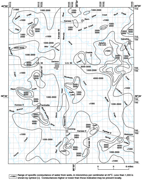
The ability of water to conduct an electric current provides an indication of the ionic concentration of dissolved minerals in the water. High specific conductance values generally correlate with high mineralization of the water. Specific conductance values greater than 1,000 micromhos per centimeter at 25°C are common in many parts of the county (fig. 8) and values as great as 5,000 micromhos per centimeter at 25°C have been measured.
Figure 8--Specific conductance of water from wells in unconsolidated and bedrock aquifers, 1968-72.
Specific conductance of water from wells in Nemaha County is directly related to the concentration of sulfate in the water (fig. 9.). Concentrations of sulfate range from 10 mg/l to as much as 2,100 mg/l. Sulfate in drinking water is significant because concentrations greater than 250 mg/l, particularly in association with magnesium, can cause an undesirable laxative effect in persons unaccustomed to drinking such water (Kansas State Board of Health, 1973).
Figure 9--Concentration of sulfate in water from wells in unconsolidated and bedrock aquifers, 1968-72.
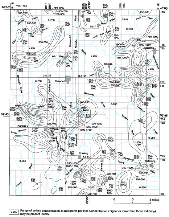
Comparison of figures 3, 4, 8, and 9 indicates that water with high values of specific conductance and high concentrations of sulfate are from wells in the Permian rocks and in the deeply buried glacial deposits. The source of the sulfate is dissolution of thin layers of gypsum in the Permian rocks by ground water, which moves from the bedrock into the basal gravel of the glacial deposits because of higher hydrostatic beads, Shallow wells that do not tap the basal gravel should yield water having lower concentrations of sulfate.
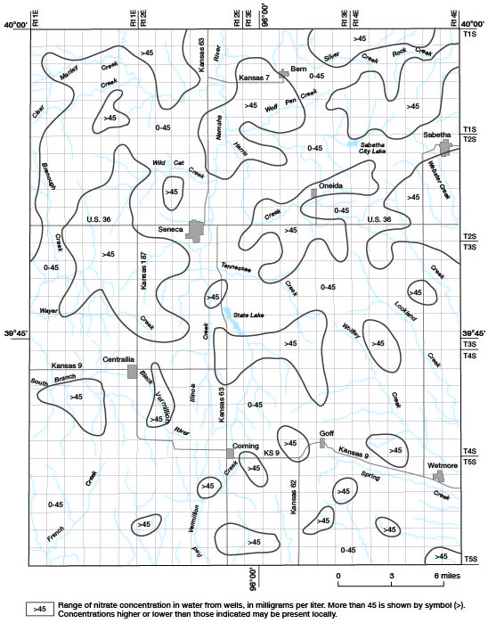
Nitrate concentrations in excess of 45 mg/l occur in water from relatively shallow wells in Nickerson Till or younger deposits. Several bedrock wells also yield water with a high nitrate content. Areas where the concentration of nitrate in ground water exceeds 45 mg/l, which is the recommended limit in drinking water (Kansas State Board of Health, 1973), are shown on figure 10. Approximately 40 percent of the analyses had concentrations of nitrate greater than 45 mg/l, with the greatest being 490 mg/l.
Figure 10--Concentration of nitrate in water from wells in unconsolidated and bedrock aquifers, 1968-72.
Future development of ground water in the county will be limited by both quantity and quality of water. Large demands, such as public supplies, rural water districts, and industries will be limited to a maximum of about 300 gpm from individual wells. Supplies larger than 300 gpm must be obtained by a series of two or more wells. In the area several miles east and southeast of Seneca and in the southwestern part of the county, Nebraskan(?) basal gravel and Kansan glaciofluvial deposits are suitable for the development of large supplies of water of relatively good quality. If chemical quality of the water is a consideration, as for public supplies, the concentration of sulfate in water from wells may further limit development of the resource. Large supplies of water suitable for irrigation are absent.
Sufficient quantities of ground water are available from bedrock and glacial deposits in most areas of the county for domestic and stock demands. The quality of water commonly is poor as a result of a high concentration of sulfate. Because of a combination of low yields and poor quality of water, about one-half of the county, including two public supplies, has been supplied by rural water districts. The water for these districts is obtained from existing public supplies or from new wells where large quantities of water of good quality are available. The city of Sabetha depends on a surface supply. Although existing farm wells may continue to supply stock needs, many wells probably will be abandoned because of the availability of more suitable water from rural water districts.
Bayne, C. K., 1968, Evidence of multiple stades in the lower Pleistocene of northeastern Kansas: Kansas Acad. Sci. Trans., v. 71, no. 3, p. 340-349.
Bayne, C. K., and Schoewe, W. H., 1967, Geology and groundwater resources of Brown County, Kansas: Kansas Geol. Survey Bull. 186, 68 p. [available online]
Emery, P. A., 1964, Geology and ground-water resources of Richardson County, Nebraska: U.S. Geol. Survey Water-Supply Paper 1779-W, 29 p. [available online]
Frye, J. C., and Leonard, A. B., 1952, Pleistocene geology of Kansas: Kansas Geol. Survey Bull. 99, 230 p. [available online]
Frye, J. C., and Walters, K. L., 1950, Subsurface reconnaissance of glacial deposits in northeastern Kansas: Kansas Geol. Survey Bull. 86, pt. 6, p. 141-158. [available online]
Hargadine, G. D., 1970, Materials inventory of Nemaha County, Kansas: State Highway Commission of Kansas Materials Inventory Rept. No. 19, 158 p.
Kansas State Board of Health, 1973, Water quality criteria for interstate and intrastate waters of Kansas: Kansas State Board of Health Regulations, 28-16-28, 5 p.
Moore, R. C., 1949, Divisions of the Pennsylvanian System in Kansas: Kansas Geol. Survey Bull. 83, 203 p. [available online]
Mudge, M. E., Walters, C. P., and Skoog, R. E., 1959, Geology and construction-material resources of Nemaha County, Kansas: U.S. Geol. Survey Bull. 1060-D, p. 179-256. [available online]
Mudge, M. E., and Yochelson, E. L., 1962, Stratigraphy and paleontology of the uppermost Pennsylvanian and lowermost Permian rocks in Kansas: U.S. Geol. Survey Prof. Paper 323, 213 p. [available online]
Reed, E. C., and Dreezen, V. H., 1965, Revision of the classification of the Pleistocene deposits of Nebraska: Nebraska Geol. Survey Bull. 23, 65 p.
Scott, G. R., Foster, F. W., and Crumpton, C. F., 1959, Geology and construction-material resources of Pottawatomie County, Kansas: U.S. Geol. Survey Bull. 1060-C, p. 97-178. [available online]
Walters, K. L., 1953, Geology and ground-water resources of Jackson County, Kansas: Kansas Geol. Survey Bull. 101, 90 P. [available online]
Walters, K. L., 1954, Geology and ground-water resources of Marshall County, Kansas: Kansas Geol. Survey Bull. 106, 116 p. [available online]
Zeller, D. E., ed., 1968, The stratigraphic succession in Kansas: Kansas Geol. Survey Bull. 189, 81 p. [available online]
Kansas Geological Survey, Nehama County, Kansas
Placed on web Sept. 8, 2010; originally published in Nov. 1974.
Comments to webadmin@kgs.ku.edu
The URL for this page is http://www.kgs.ku.edu/Publications/Bulletins/GW2/index.html