Kansas Geological Survey, Bulletin 86, Part 6, originally published in 1950
Originally published in 1950 as Kansas Geological Survey Bulletin 86, Part 6. This is, in general, the original text as published. The information has not been updated.
In northeastern Kansas, deposits made directly or indirectly by continental glaciation and the alluvial fills of valleys are the most important sources of ground-water supply. During 1948 and 1949 a subsurface reconnaissance of these deposits was made. The results of the work, including the records of 64 test holes, are described in this report and presented on cross sections. The stratigraphic sequence is described.
Since 1937 the State and Federal Geological Surveys, with cooperation of the Division of Water Resources of the State Board of Agriculture and Division of Sanitation of the State Board of Health, have been investigating the ground-water resources of Kansas. The quantity, quality, and recoverability of ground-water supplies of any area are generally controlled by the character and configuration of the rock layers. Therefore the several geologic provinces of the State present markedly different problems to the ground-water geologist. During the early period of ground-water investigation, studies were concentrated in the central and western parts of the State. More recently studies were undertaken in the relatively more humid east-central areas, and now in the glaciated northeastern area.
The problems of well-water supply in northeastern Kansas are distinct from those in all other parts of the State because only this relatively small area was invaded by ice sheets during the Pleistocene or "glacial" Epoch. In Kansas the deposits made by ice or derived from glacial meltwaters attain a maximum thickness of 400 feet and form a discontinuous mantle over much of the area lying north of Kansas River and east of Big Blue River. Although both of these valleys were crossed by glaciers at a few places, the glacial deposits beyond these limits are of small importance as sources of well water. The limit of glacial deposits has been mapped by Schoewe (1930; 1939; 1949) and is shown on the index map in Plate 1 (available as an Acrobat PDF file).
Most potable ground-water reserves of northeastern Kansas occur either in glacially derived deposits or in valley alluvium. Furthermore, at many places the water encountered in bedrock is too highly mineralized to be usable for most purposes. These facts point to the need for general information about the Pleistocene glacial deposits before successful detailed ground-water studies can be completed in northeastern Kansas. It is the purpose of this report to present the results of a subsurface reconnaissance of these deposits.
Samples that furnish many of the data on which this report is based were obtained during 1948 and 1949 by use of the State Geological Survey's portable hydraulic-rotary drill which is operated as a part of the cooperative ground-water program. Sixty-four test holes were drilled by William Connor and Max Yazza and logged in the field by K. L. Walters. Samples were subsequently studied microscopically in the laboratory. Locations of test holes used in the construction of cross sections are shown on the index map in Plate 1, and data concerning them are given in Table 1. Altitude of the ground surface at the test holes and intervening instrumental control for the cross sections shown in Plate 1 were run by Charles K. Bayne, W. W. Wilson, and K. L. Walters during 1949. In addition to information derived from the test-drilling program all other available data were utilized in this study. These additional data were obtained by A. Byron Leonard, A. R. Leonard, Norman Plummer, and us from study of surface exposures, cuttings from hand-auger holes, and molluscan faunas. The work of the Ground Water Branch of the U. S. Geological Survey was under the general administration of Dr. A. N. Sayre, Chief.
Table 1--Test holes drilled through the glacial deposits of northeastern Kansas, 1948-1949.
| Location of test hole | Depth to bedrock, feet |
Total thickness of sand and gravel, feet |
Depth to water level, feet |
Altitude of land surface, feet |
|---|---|---|---|---|
| NE NE sec. 28, T. 1 S., R. 8 E. | 50 | 0 | 30.2 | 1,345.5 |
| SE cor. SW sec. 17, T. 1 S., R. 9 E. | 45 | 0 | 11.9 | 1,423.9 |
| SE cor. sec. 23, T. 1 S., R. 9 E. | 8 | 0 | 1,416.7 | |
| NW NW sec. 26, T. 1 S., R. 9 E. | 89 | 0 | 10.9 | 1,487.9 |
| NW NW sec. 27, T. 1 S., R. 9 E. | 77 | 7 | 36.0 | 1,452.7 |
| NW NW sec. 28, T. 1 S., R. 9 E. | 38.5 | 9.5 | 11.9 | 1,400.3 |
| NW NW sec. 30, T. 1 S., R. 10 E. | 133 | 5 | 14.7 | 1,502.2 |
| NE cor. sec. 29, T. 1 S., R. 10 E. | 89 | 0 | 12.7 | 1,446.7 |
| NE cor. SE sec. 1, T. 1 S., R. 10 E. | 71 | 0 | 22.8 | 1,305.3 |
| NW SW sec. 30, T. 1 S., R. 11 E. | 97 | 9 | 15.5 | 1,355.7 |
| sec. 8, T. 1 S., R. 19 E. | 147 | 0 | 1,066.6 | |
| SE NW sec. 22, T. 1 S., R. 19 E. | 256.5 | 3 | 1,050.6 | |
| SE cor. sec. 25, T. 2 S., R. 9 E. | 36 | 0 | 1,373.8 | |
| SE cor. sec. 25, T. 2 S., R. 10 E. | 68 | 13 | 10.7 | 1,334.0 |
| SE cor. sec. 29, T. 2 S., R. 10 E. | 102 | 13.5 | 16.8 | 1,385.1 |
| SW cor. sec. 6, T. 2 S., R. 11 E. | 84 | 39 | 9.45 | 1,338.0 |
| NW SW sec. 1, T. 2 S., R. 19 E. | 207 | 81 | 1,038.2 | |
| SE cor. NE sec. 36, T. 2 S., R. 19 E. | 124 | 59 | 48.6 | 1,059.0 |
| NW NW sec. 19, T. 2 S., R. 20 E. | 91.5 | 31 | 1,023.3 | |
| SW SW sec. 18, T. 3 S., R. 11 E. | 49 | 10 | 27.6 | 1,334.6 |
| SW NW sec. 30, T. 3 S., R. 20 E. | 35 | 0 | 1,045.6 | |
| SE cor. NE sec. 3, T. 3 S., R. 21 E. | 154 | 10 | 67.3 | 1,165.1 |
| SW NW sec. 23, T. 3 S., R. 21 E. | 55 | 6 | 1,059.3 | |
| SW cor. SE sec. 29, T. 4 S., R. 10 E. | 150 | 0 | 17.0 | 1,332.5 |
| SE cor. SW sec. 27, T. 4 S., R. 10 E | 300 | 34 | 23.5 | 1,371.0 |
| SE NE sec. 1, T. 4 S., R. 10 E. | 95 | 5 | 6.7 | 1,337.5 |
| SE cor. sec. 25, T. 4 S., R. 10 E. | 335 | 7.5 | 40.6 | 1,358.7 |
| NE NE sec. 35, T. 4 S., R. 11 E. | 344.5 | 33.5 | 1,361.3 | |
| NE cor. SE sec. 33, T. 4 S., R. 12 E. | 380 | 94 | 22.8 | 1,382.3 |
| NE cor. NW sec. 31, T. 4 S., R. 13 E. | 300 | 68 | 29.0 | 1,382.6 |
| SE cor. sec. 26, T. 4 S., R. 13 E. | 196 | 0 | 25.4 | 1,306.5 |
| SW cor. sec. 27, T. 4 S., R. 14 E. | 232 | 11 | 37.2 | 1,191.1 |
| SW SE sec. 27, T. 4 S., R. 14 E. | 153.5 | 93.5 | 7.4 | 1,095.0 |
| SE SW, sec. 25, T. 4 S., R. 14 E. | 214 | 36 | 18.5 | 1,200.0 |
| SE cor. SW sec. 35, T. 4 S., R., 15 E. | 115 | 30.5 | 18.66 | 1,160.6 |
| SE cor. sec. 31, T. 4 S., R. 16 E. | 64 | 15 | 11.58 | 1,124.1 |
| SE SW sec. 35, T. 4 S., R. 16 E. | 17 | 6 | 11.25 | 1,125.8 |
| NW NW sec. 7, T. 4 S., R. 20 E. | 30 | 0 | 1,039.3 | |
| NE NE sec. 35, T. 4 S., R. 20 E. | 26 | 0 | 1,043.2 | |
| SE SW sec. 10, T. 4 S., R. 21 E. | 146 | 55.5 | 37.65 | 1,030.6 |
| NW cor. NE sec. 34, T. 4 S., R. 21 E. | 45 | 7 | 1,010.4 | |
| NE cor. sec. 30, T. 5 S., R. 11 E. | 100 | 20 | 1,292.2 | |
| SE NE sec. 16, T. 5 S., R. 14 E. | 199 | 29 | 31.6 | 1,269.0 |
| SE cor. NE sec. 33, T. 5 S., R. 14 E. | 193 | 96 | 58.7 | 1,253.7 |
| NE cor. sec. 25, T. 5 S., R. 15 E. | 163 | 4 | 24.3 | 1,131.4 |
| NW cor. NE sec. 2, T. 5 S., R. 17 E. | 30 | 0 | 17.2 | 1,107.4 |
| NW NW sec. 5, T. 5 S., R. 18 E. | 67 | 0 | 7.1 | 1,137.2 |
| NE NE sec. 2, T. 5 S., R. 18 E. | 96 | 0 | 9.4 | 1,170.0 |
| NE NW sec. 4, T. 5 S., R. 19 E. | 106.5 | 16.5 | 24.3 | 1,102.4 |
| NW SW sec. 6, T. 5 S., R. 20 E. | 34.5 | 11.5 | 23.2 | 1,053.8 |
| SE SE sec. 9, T. 6 S., R. 14 E. | 151 | 21 | 21.6 | 1,260.0 |
| SE cor. NE sec. 1, T. 6 S., R. 15 E. | 156.5 | 83.5 | 4.8 | 1,084.5 |
| SE SE sec. 25, T. 6 S., R. 15 E. | 68 | 27 | 1,098.9 | |
| SW cor. sec. 24, T. 6 S., R. 17 E. | 212 | 62 | 24.3 | 1,100.2 |
| SW cor. sec. 36, T. 6 S., R. 17 E. | 112 | 0 | 20.1 | 1,081.6 |
| SE NE sec. 1, T. 6 S., R. 19 E. | 149 | 88 | 42.9 | 1,108.3 |
| NE SE sec. 25, T. 6 S., R. 19 E. | 99 | 24 | 39.3 | 1,071.8 |
| NW NW sec. 3, T. 7 S., R. 14 E. | 124 | 13 | 28.9 | 1,256.3 |
| NW NE sec. 12, T. 7 S., R. 19 E. | 56.5 | 0 | 1,043.2 | |
| SW SE sec. 30, T. 7 S., R. 20 E. | 26.5 | 0 | 9.5 | 1,084.8 |
| NW SE sec. 18, T. 8 S., R. 20 E. | 68 | 5 | 28.5 | 1,172.7 |
| SE NW sec. 6, T. 9 S., R. 20 E. | 44 | 0 | 8.4 | 1,114.6 |
| SE NW sec. 31, T. 9 S., R. 20 E. | 72 | 8 | 1,127.0 | |
| SE NW sec. 19, T. 10 S., R. 20 E. | 4.5 | 1,150.9 | ||
| NE SE sec. 8, T. 12 S., R. 20 E. | 62.5 | 10.5 | 894.0 |
Rocks of Pennsylvanian* and Permian age underlie all the glaciated area of Kansas at depths of as much as 400 feet. The bedrock formations dip gently to the west-northwest. In the western part of the area the dip is reversed locally on the eastern flank of the Nemaha anticline. The test drilling on which this report is based did not penetrate the Pennsylvanian and Permian strata sufficiently to provide useful stratigraphic information. Accordingly, the bedrock of the glaciated area is described by groups and shown only in a generalized way on the cross sections (Pl. 1). [Note: The geologic classification and nomenclature of this report follow usage of the State Geological Survey of Kansas.]
The Douglas group of the Virgilian Series crops out along Kansas River Valley at Lawrence and may be traced northward along Missouri River Valley to within a few miles of Iowa Point in Doniphan County. The rocks of this group have been described by Moore (1936, p. 145) as follows:
The Douglas group comprises the lowermost part of the Virgil series, extending from the disconformity that marks the lower boundary of the series to the base of the Oread limestone . . . .
As thus defined, the Douglas group consists primarily of clastic deposits in which fairly thick bodies of massive or crossbedded sandstone, shaly sandstone, and sandy shale are prominent. The group contains two persistent, though rather thin, limestone beds, the Haskell and Westphalia limestones in the middle or lower part, and there are some coal beds. Locally, especially at the base of the group, there are deposits of conglomerate.
The thickness of the Douglas group in this area is about 175 feet. The Shawnee group overlies the Douglas group, and crops out in eastern Jefferson, Atchison, and Doniphan Counties. The rocks of this group have been described by Moore (1949, pp. 139-143) as follows:
The Shawnee group as redefined by Moore (1936, p. 159) includes beds from the base of the Oread limestone to the top of the Topeka limestone . . . .
Four formations assigned to the Shawnee group are largely, if not predominantly, made up of limestone. The three intervening formations consist mainly of shale and sandstone. These alternating calcareous and clastic deposits reflect major cyclic oscillations of sedimentation, which furnish evidence of important back and forth shifting of the strand lines of Virgilian seas. Sedimentation associated with retreat of the shallow seas consists of coal beds and nonmarine sandstone and shale, some of which contain well-preserved land plants. Marine sedimentation is represented by the limestones and by several types of shaly deposits . . . .
The Shawnee group contains the following formations, named in upward order: Oread limestone, Kanwaka shale, Lecompton limestone, Tecumseh shale, Deer Creek limestone, Calhoun shale, and Topeka limestone.
The thickness of the Shawnee group in this area is about 350 feet. Rocks of the Wabaunsee group crop out along a belt about 20 miles wide through western Jefferson County, eastern Jackson County, the western two-thirds of Atchison County, western Doniphan County, eastern Brown County, and west-central Nemaha County. The Wabaunsee group overlies the Shawnee group and includes beds from the top of the Topeka limestone to the base of the Permian System. The rocks of this group have been described by Moore (1949, p. 167) as follows:
The Wabaunsee group is distinguished chiefly by its general lithologic features and by the character of its cyclothems from the underlying Shawnee and succeeding Lower Permian beds, but there are also some faunal peculiarities. Shale is relatively much more prominent in the Wabaunsee group than in adjoining parts of the geologic section. . . Much of the shale is sandy and at several horizons there are extensive sandstones. The Wabaunsee limestones are very persistent but are uniformly thin, the average thickness of individual members being only 2 to 3 feet. A distinctive feature of the Wabaunsee group is the character of the cyclic sedimentary succession, which shows regularly alternating nonmarine and marine units.
The thickness of the Wabaunsee group in this area is 400 to 500 feet.
The Admire group is the lowermost of the Permian System, and crops out along a narrow belt west of the main outcrop area of the Wabaunsee group and on both flanks of the Nemaha anticline in Nemaha and Marshall counties. The lower contact is marked by a disconformity and locally by sandstones which fill channels cut into the Wabaunsee rocks. The strata are chiefly clastic deposits, shale being the predominant rock type, but they contain thin beds of limestone and some coal. Rocks of this group are very poorly exposed in northeastern Kansas as in most places they are mantled by glacial deposits. The thickness of the Admire group is 125 to 225 feet.
The Council Grove group is exposed more widely in this area than the other groups of Permian rocks. Council Grove rocks are exposed in eastern Nemaha, western Jackson, and eastern Marshall Counties and include beds between the top of the Hamlin shale and the base of the Wreford limestone. The group is characterized by units consisting of two limestones and an intervening shale, alternating with units composed of thick varicolored shale. Limestones of the Council Grove group are thicker and more massive than those of the Admire group. The thickness of the Council Grove group is about 325 feet.
The lower formations of the Chase group, less than 150 feet in thickness, crop out in a small area in northeastern Nemaha County and more extensively in central Marshall County. The most distinctive feature of these rocks is the presence of thick cherty limestone beds.
Studies of glacial deposits have not been carried on intensively in northeastern Kansas. However, the area is bordered on the northeast, north, and west by regions in which the Pleistocene sediments have been studied previously in detail and relatively complete classificatory systems developed. For the most part, correlations reported here are made with adjacent areas and new names are not proposed. Classification of these deposits as now in use by the State Geological Survey of Kansas has recently been published (Frye and A. B. Leonard, 1949). The following paragraphs describe briefly the general lithologic character and mode of origin of the several stratigraphic units. Although adequate data concerning water supplies in each unit are not as yet available, some general information is presented for each.
Deposits of gravel clearly distinguishable from the glacially derived sediments have been known for many years in scattered localities in northeastern Kansas (Todd, 1918, 1920; Frye, 1941). Although these gravels were penetrated by only two test holes (Pl. 1, C-C'), they have been studied in outcrop sections and their character is known. The gravels consist wholly of chert and limestone typical of the rocks cropping out between Missouri River Valley and the line of outcrop of the Herington limestone, generally parallel to and west of Big Blue River Valley. Chert is the predominant rock type present and the pebbles generally do not exceed 3 inches in maximum diameter. The gravels do not contain representatives of quartzite or igneous rocks which are typical of the glacial deposits brought into Kansas from the north and northeast; therefore they are judged to have been derived locally and to have been carried to their place of deposition by east- or southeast-flowing streams whose headwaters did not lie far west of the line of outcrop of the Herington limestone. A farther westward extent of the headwaters of the depositing streams would have allowed the incorporation of igneous materials of Rocky Mountain origin, which are characteristic elements of the lithology of the Pliocene Ogallala formation, widely distributed over the Great Plains part of Kansas.
The age of these chert gravels is considered to be pre-glacial (late Tertiary or earliest Pleistocene) because at most localities where they have been observed in the glaciated area north of Kansas River Valley they occur above Pennsylvanian bedrock and below glacial deposits. Although the gravels underlie glacial deposits it is possible that they may be of earliest Pleistocene age, deposition having been caused by reduced gradients of eastward-flowing streams under influence of the advancing Nebraskan ice. South of the glacial border, chert gravels of similar lithology occur at widely distributed localities on terrace surfaces at several levels. Those gravels on high topographic positions have been considered to be of late Tertiary age and to correspond to the Pliocene Ogallala formation in western and central Kansas.
Chert gravels may be a source of ground water at a few places, but their thinness and patchy occurrence make them relatively unimportant.
David City formation--Gravels of glacial origin occurring below Nebraska till and above bedrock in Nebraska have been named the David City formation (Lugn, 1935, pp. 38-40). Similar gravels are described from northeastern Kansas (Frye and A. B. Leonard, 1949). The gravels of the David City formation are distinguishable from younger deposits by their stratigraphic position below Nebraska till and from the older pre-glacial chert gravels by their marked contrast in lithology. They are characterized by pebbles of pink quartzite and of crystalline and sedimentary rock types such as occur generally in the overlying glacial deposits. These gravels are judged to be pro-Nebraskan, deposited by waters flowing from the front of the advancing ice sheet and subsequently overridden by the glacier.
The importance of the gravels of the David City formation as a source of ground-water supply is not known, since they have been recognized certainly in Kansas only in a few eastern Doniphan County outcrops.
Nebraska till--The first Pleistocene ice sheet to reach Kansas has been called Nebraskan (Shimek, 1909) because of its inferred westward extension into Nebraska. Deposits made by this ice are classed as Nebraska till and consist of boulders, pebbles, and sand in a matrix of silt and clay. Where unaffected by weathering, the Nebraska till is generally bluish gray, dense, calcareous, and impermeable; where weathered, it has a yellowish-tan to brown color, and at a few places a deep soil profile has been observed in its top (Frye and A. B. Leonard, 1949).
Owing to its low permeability, the Nebraska till probably is a poor source of ground water except where joints may be exceptionally well developed and open.
Blanco formation--Deposits of sand, gravel, and silt produced by outwash from the retreating Nebraskan glacier are classed as Blanco formation on the basis of correlation with type Blanco beds in Texas (Frye, Swineford, and Leonard, 1948). The Blanco is correlated with the Holdrege and Fullerton formations of Nebraska. Deposits assignable to this formation, although they occur widely in Nebraska and in western and central Kansas, have not been recognized in this area.
Pro-Kansan sands--The second and last glacier to invade Kansas is the one that takes its name from the state (Chamberlin, 1895; Kay and Apfel, 1929). Comparable to the advancing Nebraskan ice, the Kansan glacier discharged waters along its margin, and thick deposits of sand, silt, and gravel were laid down. These glacio-fluvial and glacio-lacustrine deposits are judged to be pro-Kansan rather than recessional Nebraskan because at all known occurrences they lack a weathered zone at the top, at the contact with Kansas till; they lack resistance to erosion but in some localities unprotected by bedrock during Aftonian time, they attain thicknesses in excess of 70 feet; large blocks of stratified sand incorporated as boulders in Kansas till show no effect of weathering; and the pro-Kansan sands are lithologically indistinguishable from water-laid sand interbedded with Kansas till. Pro-Kansan sands and silts were penetrated in many test holes and have been described from exposures in Atchison County (Todd, 1920; Schoewe, 1938; Frye, 1941).
Pro-Kansan sands and marginal outwash sand interstratified with Kansas till are perhaps the most important source of ground water in the glaciated region of Kansas. Although at some places they are of fine texture and relatively low permeability, their aggregate thickness is known to exceed 100 feet locally and their occurrence is relatively widespread.
Kansas till--The deposits produced directly by the Kansan glacier (Kansas till) are similar to the Nebraska till. Meager data suggest that Kansas till may contain a somewhat higher percentage of boulders than Nebraska till. It consists of boulders, pebbles, and sand in a clay-silt matrix. The boulders and pebbles contain pink quartzite, igneous and metamorphic rocks, and limestone. Locally, blocks of uncemented sand have been incorporated into the till. Kansas till, mantled to various depths by eolian silts, is observable at many outcrops in northeastern Kansas.
The Kansan glacial epoch (originally called Kansan stage) was named by Chamberlin (1895) and used by workers (Bain, 1897, p. 464; Kay and Apfel, 1929) in Iowa because, of supposed extension of southern Iowa till deposits into Kansas. The till constitutes the surficial material over wide areas to the east and north of Kansas and reaches its southwestern extremity a few miles northeast of Manhattan, Kansas.
Where not extensively removed by erosion or deeply covered by younger deposits, the upper part of the till is leached and soil is developed in it. Test drilling data indicate that the depth to which Kansas till has been leached of calcium carbonate varies widely, but commonly does not exceed 10 to 15 feet. At most places, the till is oxidized to a tan or brown color at depths, considerably below the zone of leaching. A few test holes indicate 50 to 60 feet of oxidized till which grades downward into blue-gray unoxidized calcareous till. Some exposures show a well-developed joint system in the till with oxidized rinds along the joints, and at least locally accumulation of calcium carbonate along the joint planes (Pl. 2).
Plate 2--Pleistocene deposits in northeastern Kansas. A, Sand and gravel interstratified with Kansas till; SW NW sec. 27, T. 6 S., R. 14 E., Jackson County. (Photo by A.R. Leonard, June 1949.) B, Joints in Kansas till showing oxidized rind and calcite filling along joint plane; SE sec. 12, T. 2 S., R. 10 E., Marshall County. (Photo by A.R. Leonard, June 1949.) C, Bignell and Peoria silt members of Sanborn formation exposed in excavation in the NE SE sec. 6, T. 2 S., R. 20 E., Doniphan County (July 1948).
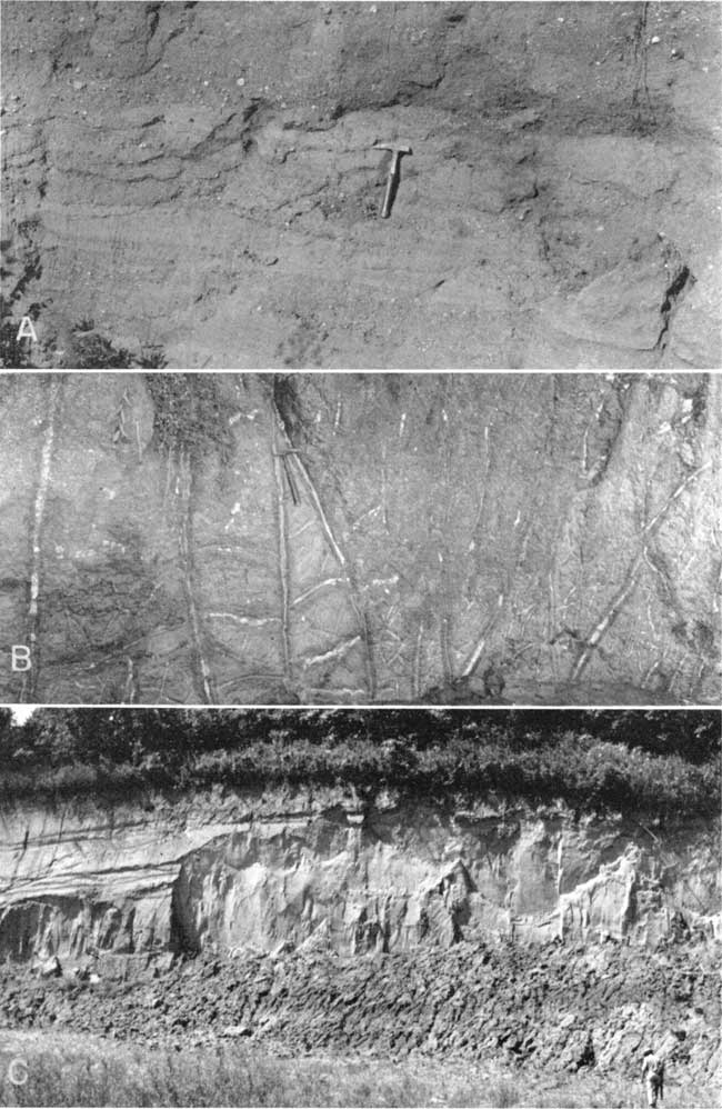
The thickness of the Kansas till greatly exceeds that of Nebraska till. As much as 300 feet of Kansas till has been penetrated in Nemaha and Marshall counties. In the area near the limit of glacial advance, sands and gravels (pro-Kansan) not only occur at the base of this till but also are interstratified with it (Pls. 1, 2). This suggests minor fluctuations of the ice margin when it was near its maximum extent and also the possible existence of englacial and superglacial streams.
Little if any ground water is obtained from the relatively impermeable Kansas till. However, in areas where sand and gravel are interstratified with till, moderate to large supplies of potable water may be obtainable from the intratill sands. In general, these sands and gravels surrounded by till are judged not to be interconnected and to lack adequate recharge or catchment areas.
Meade formation--The term Meade formation, as now used in Kansas (Frye, Swineford, and Leonard, 1948), includes members which respectively correspond to units called Grand Island formation (Condra, Reed, and Gordon, 1947) and Sappa formation in Nebraska. It includes fluvial outwash deposits made by the retreating Kansan glacier. These deposits, although penetrated by only two test holes (Pl. 1), have been observed in exposures at several places in northeastern Kansas--for example, in road cuts along U. S. Highway 36 in central Nemaha County.
The prominent high deeply dissected terrace along Kansas River Valley is judged to be composed of Kansan glacial outwash classifiable as Meade formation. The Pearlette volcanic ash bed, which serves as a stratigraphic datum and time, marker within the Sappa member, is known to occur in Doniphan, Marshall, and Nemaha counties.
Although gravels of the Grand Island member are quite permeable and although elsewhere in Kansas they form excellent ground-water reservoirs, their discontinuous, localized occurrence in northeastern Kansas and generally high topographic position make them relatively unimportant sources of ground water in the northeastern counties.
Late Pleistocene ice sheets did not closely approach Kansas. During late Pleistocene time the type of sedimentation prevalent over Kansas generally, and particularly in the northeastern area, differed markedly from that of early Pleistocene time. After final retreat of the Kansan glacier, northeastern Kansas was subjected to erosion, minor alluviation along valleys, and extensive loess deposition adjacent to valleys that carried outwash from late Pleistocene glaciers north or west of this region. Of late Pleistocene sediments, only the loesses have widespread geographic distribution. For convenience of mapping in Kansas the Illinoian and younger deposits (except stream terraces) have been assigned to the Sanborn formation, named from a locality in northwestern Kansas (Elias, 1931). This formation includes (in ascending order) the Crete sand and gravel member, named from a locality in Nebraska (Condra, Reed, and Gordon, 1947); Loveland silt member, described from exposures in western Iowa (Shimek, 1909, 1910); Peoria silt member, correlated with deposits of central Illinois; and Bignell silt member, judged to be equivalent to deposits described in western Nebraska (Schultz and Stout, 1945).
Crete sand and gravel member--Sand and gravel deposits classed as the Crete sand and gravel member are considered to be somewhat remote products of Illinoian glaciation. This member is well developed along tributaries of Republican River in north-central Kansas (Frye and A. R. Leonard, 1949). In the glaciated region, however, the Crete member has not been recognized certainly. A few intermediate terrace remnants along middle reaches of Kansas River Valley may be Crete; also the member may be a part of the 80 to 90 feet of alluvium that underlies the flat of Missouri River Valley bordering the state. It is clear that the Crete member is not extensively developed and is not an important ground-water reservoir in northeastern Kansas.
Loveland silt member--The Loveland silt member has been recognized as the basal part of thick loess sections along the Missouri River bluffs and as thin deposits capping some upland areas in Marshall County (Frye and others 1949; Frye and A. B. Leonard, 1949). It commonly is tan to brown silt with a relatively high clay content, deeply leached of calcium carbonate, and bounded at the top by the prominent buried Sangamon soil. Its texture, structure, areal distribution, topographic and stratigraphic position, and relation to buried soils indicate that it is an eolian deposit derived from the valley flats of outwash-carrying streams of late Illinoian time. It is commonly above the water table and is not an important source of water for wells.
Peoria silt member--The Peoria silt member of the Sanborn formation is the most widespread stratigraphic unit of Pleistocene age in Kansas. It ranges in thickness from considerably more than 100 feet in Doniphan County to a thin veneer on uplands in much of this area. It is judged to be an eolian deposit derived from outwash of early Wisconsinan age carried by Missouri, Kansas, Republican, and Platte rivers. It is correlated with other regions on the basis of its stratigraphic position, molluscan fauna (Frye and A. B. Leonard, 1949), and character of buried soils below it and in its top. In general, it is a tan massive silt which is calcareous where sufficiently thick and where overlain by the younger Bignell silt member containing the prominent buried Brady soil (Schultz and Stout, 1948) in its upper part. Although widely distributed, the Peoria member is generally above the water table, and its permeability--even though markedly greater than that of the massive tills--is not high.
Bignell silt member--The Bignell silt member of the Sanborn formation has been recognized in northeastern Kansas only along bluffs of Missouri River in Doniphan County. It closely resembles the Peoria in lithology and was derived from outwash of late Wisconsinan age. It is not a source of ground water in this area.
Deposits of alluvium under many flat valley bottoms of the area and under low terrace surfaces of larger valleys are second only to sand derived from Kansan glaciation as sources of ground water. In fact, their generally higher permeability and association with permanently flowing streams may render the alluvial deposits more important quantitatively than the more widespread glacial deposits.
Sand, gravel, silt, and clay commonly attain a thickness of 60 to 90 feet below the valley flats of Kansas (Lohman, 1941) and Missouri (Lohman and Mitchell, 1940; Fishel, 1948) Rivers. The position of these alluvial deposits in valleys cut through Kansas till, absence of Loveland and Peoria loesses from low terrace surfaces, and almost complete lack of dissection of terraces, supplemented by meager paleontological evidence, indicate, that the low terraces in northeastern Kansas valleys are no older than Wisconsinan and that the alluvium under valley flats may be late Wisconsinan or Recent in age.
The thickness of alluvium in tributary valleys varies widely, but commonly does not exceed 40 feet. In the smaller valleys, the terrace materials are not important as sources of ground water. The quality of water obtained from alluvial and terrace materials is generally suitable for most purposes, but in some places or for some uses the relatively high degree of hardness may be objectionable.
Six cross sections through the glaciated region of Kansas are presented in Plate 1. These sections are based on the 64 test holes and available surface data. For sake of clarity the Pleistocene materials are classified in only a few lithologic categories; subdivision of the three silt members of the Sanborn formation was not attempted. For the most part, the cross sections are self explanatory. However, several significant features brought to light by this reconnaissance call for special notice.
The relation of the loess thickness to location along the Missouri Valley bluffs is shown strikingly on section E-E'. The north end of this section is in the area of thickest loess known in Kansas. The loess mantle thins rapidly toward the south across Doniphan County, becomes patchy in Atchison County, and virtually disappears in Jefferson County. Section F-F' in eastern Doniphan County shows the generally great thickness of loess within the eastward loop described by the Missouri Valley, and C-C' shows the thin cover of upland loess south of that loop. Section A-A' illustrates the eastward thinning of loess derived from Republican River Valley to the west. Although subdivisions are not shown, the bulk of the Sanborn formation of this area is known to be assignable to the Peoria silt member.
Subdivision of Nebraska and Kansas glacial tills was possible in the subsurface only in Doniphan County, where both tills are thin, but because of wide spacing of control points, the contact between them was not drawn on the sections. Nebraska till may extend as far as Nemaha County and as far south as southern Atchison County. The continuity of lithology penetrated in all tests west and south of these counties suggests that the Kansas till considerably overlaps Nebraska till and accordingly is the most extensive glacial deposit in Kansas.
Terminal moraines have not been recognized in this area. However, the marked thickening of till shown on section E-E' a few miles north of Kansas River Valley; on C-C' in southeastern Marshall County and southwestern Nemaha County; on B-B' north of the Pottawatomie County line; and on D-D' in southern Nemaha County, suggest a nearly stabilized position of the ice front and the resultant development of an end moraine. The interfingering of outwash sands and gravels in these same areas supports such a conclusion. The Kansas till is known to extend beyond the position of this possible moraine both to the south and to the west. Therefore, this feature, if it really constitutes an end moraine, is either a terminal moraine built by readvance of the ice front, or a recessional moraine built by halt of the ice front during retreat.
A prominent low area in the bedrock surface has, been found to exist in southern Nemaha County and northern Jackson County. This low is shown on the index map in Plate 1 by a stippled pattern. At most places where test holes penetrated this low area, sand and gravel were encountered immediately above bedrock. These deposits display the same lithology as those interstratified with the till and are judged to be associated with the advance of Kansan ice,. Their lithology precludes the possibility of classing them with preglacial chert gravels, and absence of recognizable Nebraska till throughout this low area is strong evidence against their being Nebraskan outwash. It is judged that this bedrock "sag" probably represents a post-Nebraskan, pre-Kansan valley eroded in marginal position to the Nebraskan ice front. This valley was overridden by the advancing Kansan glacier.
The cross sections show that the surface traversed by the glaciers had less relief than that of the present surface. The entrenchment of many minor streams through the glacial deposits into bedrock, the relatively high position of late Tertiary (or earliest Pleistocene) chert gravels (section C-C') with respect to present drainageways, and the position of the Kansan terrace along Kansas River Valley (section E-E') all indicate accentuation of topographic relief during late Pleistocene time.
In a reconnaissance such as this, it is inevitable that many minor and some major features of the glacial geology of northeastern Kansas have been missed or misinterpreted. More detailed studies of the geology and ground-water resources of the northeastern Kansas counties are in progress. The data presented here should aid development of water supplies and serve as partial foundation for future geologic work on the glacial deposits in Kansas.
Bain, H. F. (1897) Relations of the Wisconsin and Kansan drift sheets in central Iowa and related phenomena: Iowa Geol. Survey, vol. 6, pp. 429-476.
Chamberlin, T. C. (1895) The classification of American glacial deposits: Jour. Geology, vol. 3, pp. 270-277.
Condra, G. E., Reed, E. C., and Gordon, E. D. (1947) Correlation of the Pleistocene deposits of Nebraska: Nebraska Geol. Survey, Bull. 15, pp. 1-73, figs. 1-15.
Elias, M. K. (1931) Geology of Wallace County, Kansas: Kansas Geol. Survey, Bull. 18, pp. 1-254, figs. 1-7, pls. 1-42. [available online]
Fishel, V. C. (1948) Ground-water resources of the Kansas City, Kansas, area: Kansas Geol. Survey, Bull. 71, pp. 1-109, figs. 1-12, pls. 1-3. [available online]
Frye, J. C. (1941) Reconnaissance of ground-water resources in Atchison County, Kansas: Kansas Geol. Survey, Bull. 38, pt. 9, pp. 237-260, figs. 1-6, pls. 1-3. [available online]
Frye, J. C., and Leonard, A. B. (1949) Pleistocene stratigraphic sequence in northeastern Kansas: Am. Jour. Sci., vol. 247, pp. 883-899, figs. 1-3, pl. 1.
Frye, J.C., and Leonard, A. R. (1949) Geology and ground-water resources of Norton County and northwestern Phillips County, Kansas: Kansas Geol. Survey, Bull. 81. pp. 1-144, figs. 1-11, pls. 1-10. [available online]
Frye, J. C., and others (1949) Ceramic utilization of northern Kansas Pleistocene loesses and fossil soils: Kansas Geol. Survey, Bull. 82, pt. 3, pp. 49-124, figs. 1-10, pls. 1-3. [available online]
Frye, J. C., Swineford, Ada, and Leonard, A. B. (1948) Correlation of Pleistocene deposits of the central Great Plains with the glacial section: Jour. Geology, vol. 56, no. 6, pp. 501-525, figs. 1-3, pls. 1-2.
Kay, G. F., and Apfel, E. T. (1929) The pre-Illinoian Pleistocene geology of Iowa: Iowa Geol. Survey, vol. 34, pp. 1-304, figs. 1-63, pls. 1-3.
Lohman, S. W. (1941) Ground-water conditions in the vicinity of Lawrence, Kansas: Kansas Geol. Survey, Bull. 38, pt. 2, pp. 17-64, figs. 1-5, pls. 1-2. [available online]
Lohman, S. W., and Mitchell, A. (1940) Memorandum in regard to prospecting for a softer water supply for the Kansas State Penitentiary at Lansing, Kansas: Mimeographed rept., pp. 1-15, figs. 1-2.
Lugn, A. L. (1935) The Pleistocene geology of Nebraska: Nebraska Geol. Survey, Bull. 10, pp. 1-223, figs. 1-22, pls. 1-4.
Moore, R. C. (1936) Stratigraphic classification of the Pennsylvanian rocks of Kansas: Kansas Geol. Survey, Bull. 22, pp. 1-256, figs. 1-12. [available online]
Moore, R. C. (1949) Divisions of the Pennsylvanian System in Kansas: Kansas Geol. Survey, Bull. 83, pp. 1-203, figs. 1-37. [available online]
Schoewe, W. H. (1930) Evidences for a relocation of the drift border in eastern Kansas: Jour. Geology, vol. 38, no. 1, pp. 67-74, figs. 1-2.
Schoewe, W. H. (1938) The west Atchison glacial section (abstract): Kansas Acad. Sci., Trans., vol. 41, p. 227,
Schoewe, W. H. (1939) Evidences for the relocation of west drift border in eastern Kansas: Kansas Acad. Sci., Trans., vol. 42, p. 367, fig. 1.
Schoewe, W. H. (1949) The geography of Kansas, part II, Physical geography: Kansas Acad. Sci., Trans., vol. 52, pp. 261-333, figs. 1-55.
Schultz, C. B., and Stout, T. M. (1945) Pleistocene loess deposits of Nebraska: Am Jour. Sci., vol. 243, no. 5, pp. 231-244, figs. 1-4, pls. 1-2.
Schultz, C. B., and Stout, T. M. (1948) Pleistocene mammals and terraces in the Great Plains: Geol. Soc. America, Bull., vol. 59, no. 6, pp. 553-588, figs. 1-3, pl. 1.
Shimek, Bohumil (1909) Aftonian sands and gravels in western Iowa: Geol. Soc. America, Bull., vol. 20, pp. 399-408.
Shimek, Bohumil (1910) The Pleistocene of the Missouri Valley: Science, n. ser., vol. 31, pp. 75-76.
Todd, J. E. (1918) Kansas during the ice age: Kansas Acad. Sci., Trans., vol. 28, pp. 33-47.
Todd, J. E. (1920) Lacustrine beds near Atchison (abstract): Kansas Acad. Sci., Trans., vol. 29, pp. 116-117.
Kansas Geological Survey, Glacial Deposits in Northeastern Kansas
Placed on web Sept. 12, 2008; originally published in Dec. 1950.
Comments to webadmin@kgs.ku.edu
The URL for this page is http://www.kgs.ku.edu/Publications/Bulletins/86_6/index.html