Kansas Geological Survey, Energy Resource Series 22, originally published in 1983
Originally published in 1983 as Kansas Geological Survey Energy Resource Series 22. This is, in general, the original text as published. The information has not been updated. An Acrobat PDF file containing the complete report is available (1.7 MB).
Increased energy costs in the united States have caused renewed interest in alternatives to crude oil. In Kansas, one possible alternative source of energy is dark layers of shale that contain varying amounts of oil. This publication reports on the examination of 37 shale units found in Kansas. Tests showed the different shales produced yields ranging from trace amounts to 23.3 gallons of oil per ton of shale. These results suggest that seven shale units contain amounts of shale oil that could be economically recovered if extraction costs can be reduced. Recovery of the phosphate and uranium contained in the shale along with coal lying immediately above or below the shale can contribute to lowering extraction costs.
Dark organic-rich shales are present throughout much of the stratigraphic column of Kansas. Some of these shales yield considerable amounts of shale oil when assayed. One hundred forty samples from 37 shale units were tested for potential oil recovery. Fischer assay results indicate yields ranging from trace amounts to 23.3 gallons of oil per ton of shale.
Differences in oil recovery are directly related to the type and amount of organic matter within a shale. Vitrinite is the dominant maceral in the Upper Cretaceous and Pennsylvanian dark shales tested. The Lower Permian and Upper Ordovician shales are essentially devoid of any organic material. The Devonian-Mississippian Chattanooga Shale contains equally small amounts of phytoplankton and vitrinite.
Seven potentially economic, low-grade mixed oil shales are present in the Middle and Upper Pennsylvanian strata of eastern Kansas: the "V", Excello, Little Osage, Anna, Tacket Formation, Eudora, and Heebner shales. If shale oil, phosphate, uranium, and mineable coals were extracted concurrently from these units, extraction costs would be reduced and an economic window for potential exploitation of these oil shales might be formed.
The rapid increase in the price of crude oil in recent years stimulated interest in finding and exploiting substitutes for this commodity. In the United States, considerable interest was focused on the oil shales of the Green River Formation in Colorado, Utah, and Wyoming. However, several other areas in the United States, including Kansas, also contain oil shales.
Oil shale has been defined by Gavin (1924) as a compact, laminated rock of sedimentary origin, yielding over 33 percent of ash and containing organic matter that yields oil when distilled, but not appreciably when extracted with ordinary sol vents for petroleum. In this study, all oil shales are dark colored and yield trace (zero) to several gallons of oil per ton of shale by conventional destructive distillation methods.
Dark organic-rich shales are present in many parts of the stratigraphic column of Kansas (Schlinsog, 1982; Zeller, 1968). These shales are mainly of marine origin. Most of the shales are classified as core or off-shore shales (Heckel, 1977) in the typical Kansas cyclothem. Others were deposited during longer, high sea-level stands not related to cyclothemic deposits. Environmental conditions necessary for the formation of oil shales include extensive organic productivity, early development of anoxic conditions, and the absence of destructive organisms.
Kansas oil shales considered to be of potential economic interest must, for practical reasons related to mining techniques and economics, fulfill the following criteria: (1) be at least one meter thick, (2) yield a minimum of 10 gallons of shale oil per ton of shale (see conversion factors in appendix, page 39), and (3) satisfy an arbitrary overburden thickness to shale thickness ratio of 20:1 or less. Another economically important feature of some oil shales is their stratigraphic proximity to strippable coal beds. Kansas shales that meet these requirements are primarily of Middle and Upper Pennsylvanian age and are present in the southeastern part of the State.
The purposes of this investigation were: (1) To reassess the potential oil yield of Kansas oil shales based on assays that utilize the Modified Fischer Retort Method. (2) To assess the potential economic value of the Upper Cretaceous Sharon Springs Shale Member of the Pierre Shale as an oil shale. (3) To evaluate and assay a number of dark-colored Kansas shales with considerable thickness, which have not been previously tested for potential shale-oil recovery. (4) To examine the green Lower Permian-age shales of central Kansas for potential shale-oil yield. (5) To give an evaluation of stratigraphic and physical similarities of Kansas oil shales from field data, assays, and petrographic examinations. This will provide the means of comparing similarities between oil yields, stratigraphy, and physical properties of the shales. (6) To consider the possibility of recovering coal, phosphate, and uranium as by-products to aid in covering the economic costs of the recovery of shale oil from oil shales.
Few studies exist that evaluate Kansas shales for potential oil recovery. A study by Runnels and others (1952) determined the extent and shale-oil yield of black, platy to fissile shales from 37 locations in Kansas. The shales analyzed in their study yielded from trace (zero) amounts to a maximum of 22.8 gallons of oil per ton of shale. The specific gravity of the recovered oil and gross heating values (British Thermal Units per pound of shale) of these shales were also determined.
The Runnels and others (1952) study served as the foundation for a more recent investigation of Kansas oil shales sponsored by the Kansas Energy Office (Angino and others, 1981). The latter study focused on the feasibility of using coal as an "economic aid" to making Kansas oil shales economically recoverable. This study also showed that the amount of oil shale available for extraction from the shales reviewed is approximately 33 x 109 tons with reserves of shale oil estimated at near 33 x 108 barrels at 75 percent recovery.
Numerous studies have focused on the geochemistry (Baker, 1962; James, 1970; James and Baker, 1971; Gill and others, 1972; Murphy and others, 1972; Cubitt, 1979), stratigraphy (Jewett, 1945; Howe, 1956; Emery, 1962; Jewett and others, 1965), and depositional environments (Elias, 1937; Hattin, 1962, 1965; Malinky, 1980) of the dark organic-rich shales of Kansas. These studies did not, however, consider the potential for recovery of shale oil from shales.
Thirty-seven shale units sampled at 68 locations form the basis of this study (Figs. 1, 2). Location data are given in Schlinsog (1982), which is also available as an open-file report of the Kansas Geological Survey. Most of the shales have a thickness of at least one meter and a predominantly dark color. Detailed descriptions of representative measured sections are given in Schlinsog (1982). Several shale units were omitted from this study because previous analyses (Runnels and others, 1952) indicated an absence of recoverable oil.
Figure 1--Eastern extent of outcropping Upper Cretaceous rocks and locations of measured and sampled sections of the Pierre Shale, Carlile Shale, and Graneros Shale. Also included are the Lower Permian sampled locations, black shale in the Fort Scott Limestone, Maquoketa Shale, Chattanooga Shale, Kearny Formation. The last four named shales were sampled from cores (modified from Merriam, 1963).
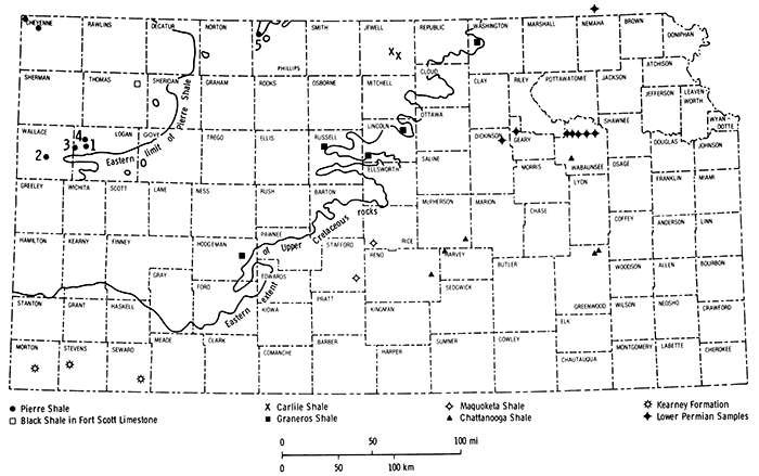
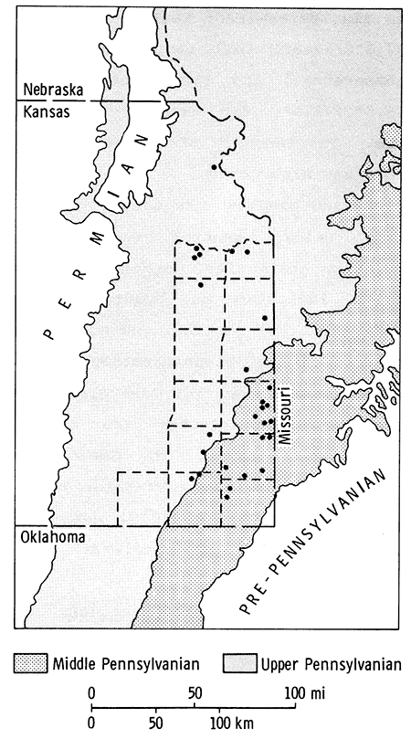
Figure 2--Distribution of outcrops of Middle and Upper Pennsylvanian rocks in eastern Kansas and parts of adjoining states. Sample locations are indicated by dots (after Moore, 1949).
The majority of the shales sampled crop out in Kansas. Exceptions are the Chattanooga Shale, Maquoketa Shale, and black shales of the Kearny Formation. These latter-named shales occur only in the subsurface in Kansas. Core samples used were from the core library of the Kansas Geological Survey.
Outcrop sampling was done by spot sampling or, where possible, by channeling. Vertical channel samples were taken over 0.3 to 0.6 meter intervals. If the outcrop was more than three meters thick, samples were taken vertically every 1.5 meters. The samples were later air dried at room temperature.
Sampling locations were selected from a review of the appropriate literature (Jewett, 1945; Runnels and others, 1952; Hattin, 1965; Gill and others, 1972; Cubitt, 1979; Heckel, 1978; and Heckel and others, 1979) and from field reconnaissance. Dr. L. L. Brady of the Kansas Geological Survey provided field assistance in locating several of the Middle Pennsylvanian shales associated with known coal beds.
All oil-shale assays were done at the Laramie Energy Technology center of the u. S. Department of Energy in Laramie, Wyoming. Before a shale was assayed using the Modified Fischer Retort Method, a preliminary rapid oil-yield test (Stanfield, 1953) was performed to evaluate the sample. This method involves placing a crushed three-gram shale sample (-8 mesh screen) in a test tube and heating it for five minutes at 600°C. The presence of oil is indicated by: (1) odor, (2) appearance of an oil condensate or white to brown vapor below the water zone, or (3) occurrence of a dark ring on the test tube walls in the refluxing zone, caused by the carbonization of the oil. An oil-yield estimate is made by comparing these results with those from samples of known oil yields. This test is suitable for estimating oil yields of three gallons of oil per ton of shale or less.
Shales that had estimated yields greater than three gallons per ton were assayed by the U. S. Bureau of Mines Fischer Retort Method (U. S. Department of Energy, 1979), which measures the quantities of oil, water, gas plus loss (calculated amount of evolved gas not condensed at 0°±3°C plus experimental error), and spent shale present in an oil-shale sample. With this procedure, samples are crushed to pass an 8-mesh screen, then a 9S±10 gram sample is placed in a cast aluminum-alloy retort. The retort is heated to 500°C and held there for 40±5 minutes. Vapors distilled from the sample are cooled and the condensate is collected. The condensate is then centrifuged to separate the oil and water evolved. Measured water volume is converted to its weight equivalent and subtracted from the oil plus water weight. The uncondensable gas weight (gas plus loss) is calculated by subtracting the condensate fraction (oil plus water weight) from total weight loss. The relative density (specific gravity) of the oil is also determined; tests are run at 37.8°C/37.8°C (oil temperature/water temperature) and then converted to 15.6°C/15.6°C for ease of comparison. The tendency of the samples to coke was also noted.
Hand samples were used to determine color, general composition, relative grain size, degree of induration, lamination and bedding, stratification and parting, and accessory components for classification. The nomenclature used for the classification follows Potter and others (1980, p. 1-12S). The Geological society of America rock-color chart (Goddard and others, 1979) was used to determine dry sample colors.
The oil-shale samples analyzed in this investigation ranged in age from Ordovician (Maquoketa Shale) to Cretaceous (Pierre Shale). A listing of sample numbers and lithostratigraphic units is given in Table 1. Detailed stratigraphic descriptions for each of the units sampled can be found in Zeller (1968) and are not repeated here. Sedimentologic data for the samples are presented in Schlinsog (1982).
Table 1--Lithostratigraphic units tested.
| Sample Numbers |
Unit | Age (Series) |
|---|---|---|
| 1-4 | Maquoketa Shale | Upper Ordovician |
| 5-15 | Chattanooga Shale | Upper Devonian |
| 16-25 | Kearny Formation | Lower Pennsylvanian |
| 26 | Black shale below Riverton coal | Middle Pennsylvanian |
| 27-30 | Black shale above Weir-Pittsburg coal | |
| 31-32 | Black shale above Tebo (Pilot) coal | |
| 33 | Black shale above Mineral coal | Middle Pennsylvanian |
| 34, 35 | Black shale above Fleming coal | |
| 36-45 | "V" shale | |
| 46-48 | Excello shale | |
| 49-59 | Little Osage Shale | |
| 60, 61 | Black shale in Fort Scott Limestone | |
| 62-66 | Anna Shale | |
| 67-73 | Tacket Formation shale | Upper Pennsylvanian |
| 74 | Ladore Shale | Upper Pennsylvanian |
| 75-77 | Hushpuckney Shale | |
| 78 | Galesburg Shale | |
| 79 | Stark Shale | |
| 80 | Vilas Shale | |
| 81-85 | Eudora Shale | |
| 86 | Lawrence Formation shale | |
| 87-90 | Heebner Shale | |
| 91 | Heumader Shale | |
| 92 | Larsh-Burroak Shale | |
| 93 | Towle Shale | Lower Permian |
| 94 | Hawxby Shale | |
| 95-97 | Hamblin Shale | |
| 98-99 | Hughes Creek Shale | |
| 100-101 | Roca Shale | |
| 102-103 | Easly Creek Shale | |
| 104-105 | Holmesville Shale | |
| 106-107 | Odell Shale | |
| 108 | Dakota Formation shale | Lower Cretaceous |
| 109-118 | Graneros Shale | Upper Cretaceous |
| 119-120 | Blue Hill Shale | |
| 121, 132-136 | Sharon Springs Shale Dark, soft shale unit |
|
| 122, 123, 125 | Sharon Springs Shale | |
| 127-131 | Organic-rich shale unit | |
| 124, 126 | Phosphatic shale unit Sharon Springs Shale |
|
| 137-140 | Unnamed shale member of Pierre Shale | Upper Cretaceous |
The 37 shale units analyzed for potential shale-oil yield were selected on the basis of color, thickness, lateral extent, and in some cases, association with coal beds. Stratigraphic units tested and their locations are given in the Appendix. Samples yielding three gallons shale oil per ton of shale or more are listed in Table 2, in which the results of the oil-shale assays using the Modified Fischer Retort Method are summarized. These results include weight percent of the oil, water, spent shale, and gas plus loss, as well as gallons of oil and water per ton of shale and specific gravity of the shale oil. Samples showed no tendency to coke. The accuracy of the results was tested by analyzing several samples in triplicate. Most of these samples yielded results within one weight percent.
Table 2--Oil shale assay by Modified Fischer Retort Method--three gallons per ton of shale or more.
| Sample Number |
Weight Percent | Gallons per ton | Specific Gravity |
||||
|---|---|---|---|---|---|---|---|
| Oil | Water | Spent Shale |
Gas + Loss* | Oil | Water | ||
| 5 | 1.8 | 1.4 | 95.7 | 1.1 | 4.6 | 3.4 | 0.920 |
| 7 | 1.9 | 1.4 | 95.8 | 0.9 | 5.0 | 3.4 | 0.92 |
| 8 | 1.2 | 1.4 | 96.3 | 1.1 | 3.1 | 3.4 | 0.92 |
| 31 | 3.8 | 1.9 | 91.6 | 2.7 | 9.9 | 4.6 | 0.924 |
| 40 | 3.1 | 3.0 | 92.1 | 1.8 | 8.1 | 7.2 | 0.918 |
| 45 | 4.9 | 2.4 | 90.1 | 2.6 | 13.0 | 5.8 | 0.913 |
| 47 | 4.8 | 2.3 | 90.7 | 2.2 | 12.6 | 5.5 | 0.922 |
| 48 | 2.9 | 2.6 | 92.7 | 1.8 | 7.5 | 6.2 | 0.923 |
| 51 | 6.1 | 3.0 | 87.7 | 3.2 | 15.8 | 7.2 | 0.927 |
| 52 | 6.1 | 2.5 | 88.7 | 2.7 | 15.7 | 6.0 | 0.929 |
| 53 | 9.0 | 2.3 | 85.4 | 3.3 | 23.3 | 5.6 | 0.922 |
| 54 | 1.5 | 3.2 | 94.6 | 0.7 | 3.9 | 7.7 | 0.920 |
| 55 | 2.3 | 3.0 | 93.4 | 1.3 | 6.3 | 7.2 | 0.898 |
| 56 | 6.7 | 2.1 | 86.3 | 4.9 | 17.4 | 5.1 | 0.918 |
| 59 | 2.0 | 3.1 | 93.8 | 1.1 | 5.2 | 7.4 | 0.920 |
| 61 | 1.9 | 2.8 | 94.4 | 0.9 | 5.0 | 6.7 | 0.92 |
| 63 | 7.0 | 5.4 | 85.6 | 2.0 | 18.3 | 12.9 | 0.918 |
| 64 | 3.0 | 3.6 | 91.8 | 1.6 | 7.9 | 8.6 | 0.912 |
| 66 | 4.9 | 3.5 | 88.3 | 3.3 | 12.8 | 8.4 | 0.914 |
| 67 | 1.2 | 1.6 | 96.3 | 0.9 | 3.1 | 3.8 | 0.920 |
| 69 | 1.2 | 2.8 | 94.8 | 1.2 | 3.2 | 6.7 | 0.92 |
| 72 | 5.3 | 1.7 | 90.0 | 3.0 | 14.0 | 4.1 | 0.903 |
| 76 | 7.3 | 4.5 | 84.3 | 3.9 | 18.6 | 10.8 | 0.943 |
| 77 | 2.2 | 6.5 | 88.8 | 2.5 | 5.6 | 15.6 | 0.937 |
| 79 | 1.9 | 7.0 | 87.7 | 3.4 | 4.8 | 16.8 | 0.920 |
| 81 | 4.3 | 5.0 | 88.3 | 2.4 | 10.8 | 12.0 | 0.945 |
| 83 | 6.7 | 4.8 | 85.7 | 2.8 | 16.4 | 11.4 | 0.970 |
| 85 | 5.9 | 6.0 | 84.2 | 3.9 | 15.0 | 14.4 | 0.942 |
| 87 | 4.2 | 6.0 | 87.5 | 2.3 | 10.5 | 14.4 | 0.960 |
| 88 | 3.4 | 7.0 | 87.4 | 2.2 | 8.5 | 16.8 | 0.954 |
| 89 | 4.0 | 5.0 | 87.7 | 3.3 | 10.0 | 12.0 | 0.953 |
| 90 | 3.2 | 6.0 | 88.0 | 2.8 | 8.0 | 14.4 | 0.945 |
| 92 | 3.6 | 6.0 | 87.6 | 2.8 | 9.1 | 14.4 | 0.941 |
| Samples showed no tendency to coke. All assays were done by DOE, Laramie, Wyoming. 0.920 = estimate of specific gravity; assumed median value (smith, 1963). * evolved gases not condensed at 0°±3°C plus experimental error. |
|||||||
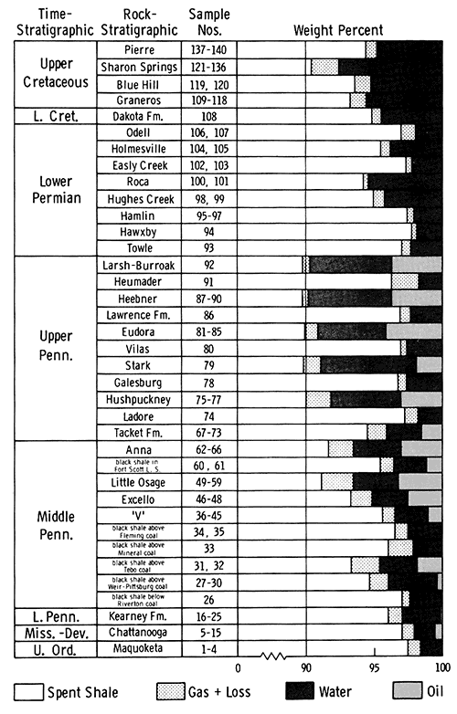
Figure 3 illustrates average oil and water yields, gas plus loss, and spent shale determined from the analyses of Kansas oil shales. Averages of weight percent were determined for all shales analyzed in this study. The largest shale-oil reserves are present in Middle and Upper Pennsylvanian strata. Average water and gas plus loss values vary from shale sample to shale sample.
Figure 3--Graphic representation of average oil and water yields, gas plus loss, and spent shale of Kansas oil shales as determined from assays (scale expanded from 90 to 100 percent).
An important factor relating to this study is the net energy return after retorting. Hutton and others (1980), following Burger's approach, estimated that at least 2.5 percent by weight of kerogen (insoluble organic matter) is necessary to obtain an energy return from an oil shale after pyrolysis. Kansas shales that contain at least 2.5 percent by weight of extractable kerogen include the Larsh-Burroak Shale, Heebner Shale, Eudora Shale, Hushpuckney Shale, Tacket Formation Shale, Anna Shale, Little Osage Shale, Excello shale, "V" shale, and the unnamed black shale above the Tebo coal.
Although none of the shales yielded extremely high amounts of oil, some are more attractive than others. Seven of the shales tested displayed some economic potential and may be sources for future exploitation. For economic and practical reasons, three factors were used to determine potential. They are: (1) oil yields greater than 10 gallons per ton of shale, (2) considerable lateral extent and, (3) minimum vertical thickness of one meter. Stratigraphic proximity to coal beds was also considered where applicable. The shales satisfying these requirements are the Heebner, Eudora, Tacket Formation, Anna, Little Osage, Excello, and "V" shales. These can be characterized by total thickness at sample locations, lithologies and thickness of oil-bearing units, and oil yield.
The total thickness of the Heebner Shale is 2.0 meters at the sites sampled (Appendix), but the unit thickens to the south of the general area. The oil-bearing unit is a black clay shale ranging in thickness from 0.9 to 1.2 meters. It yields from 8.9 to 10.5 gallons of oil per ton of shale. The Eudora Shale, where sampled, is approximately 2.0 meters thick. The oil-bearing black clay shale portion is 0.3 to 1.5 meters thick. This portion is absent, however, where the Eudora Shale overlies the algal-mound buildups in southeastern Kansas (Heckel, 1975). The black clay shale produces from 7.5 to 16.4 gallons of oil per ton of shale. A gray, bedded claymud overlies the black clay shale and was also tested. It yielded only trace amounts of oil.
The Tacket Formation is composed of two shales separated by a thin limestone. The formation thickness is variable throughout southeastern Kansas. The examined upper shale unit ranged in thickness from 3.3 to 4.4 meters and produced from trace amounts to 14.0 gallons of oil per ton of shale.
The Anna Shale ranges in thickness from 0.6 to 1.5 meters. It consists of a thin basal bedded claymud yielding trace amounts of oil, a black claystone that yields 7.9 to 18.3 gallons of oil per ton of shale, and a thin upper clay shale that yields 0.6 gallons per ton.
The Little Osage Shale ranges from 1.2 to 3.7 meters in thickness (Jewett, 1945). The upper 1.2 to 1.5 meters of this member is composed of a black claystone-clay shale. Samples from this section had the largest oil yield of all the samples tested, ranging from trace amounts to 23.3 gallons of oil per ton of shale.
The Excello shale, the upper unit in the Cherokee Group, is between 0.8 and 1.4 meters thick. It produces from trace amounts to 12.6 gallons of oil per ton of shale.
For this study, the "V" shale (see Angino and others, 1981, for definition of this unit) was considered to include all the strata between the Verdigris Limestone and Croweburg coal. The "V" shale is 3.8 to 4.5 meters thick and is composed of three shale units separated by two limestone units. The two uppermost shale units yielded from trace amounts to 1.1 gallons of oil per ton of shale and the lowermost shale unit produced 2.1 and 13.0 gallons per ton.
Several additional shales yield considerable amounts of shale oil, but do not meet the three requirements (noted earlier) defining an "economic" oil shale. These shales are the Larsh-Burroak, Stark, and Hushpuckney shales, an unnamed black shale above the Tebo coal, and the Chattanooga Shale.
Other shales analyzed yielded minor amounts of oil, but had considerable thickness. These shales include the Sharon Springs Shale, an unnamed black shale above the Weir-Pittsburg coal, and black shales of the Kearny Formation. The remaining shale samples analyzed yielded only trace amounts of oil.
The specific gravity of the oil recovered from the shales tested was also determined and the measured values ranged from 0.898 (Little Osage Shale) to 0.970 (Eudora Shale). Such values correspond to degrees API gravity of 26 to 15, which indicate heavy oil.
Oil-shale assays using retorting techniques that have been modified and improved over the past 30 years have led to the recovery of increased amounts of shale oil from samples tested. These advances suggested the need for a re-evaluation of Kansas oil shales for their oil content. Earlier studies were made on fewer samples using techniques then extant. As a consequence, the results reported in the literature have sometimes been questioned. We felt that a more extensive testing and sampling program using improved methodology would provide better estimates of potential shale-oil yield.
Comparisons between the 14 reassessed shales and previously reported values (Runnels and others, 1952) appear in Table 3. The most notable differences involve increases in the average oil yield of the Eudora and Anna Shales and maximum oil yields of the sampled units.
Table 3--Comparison of oil yields of Kansas oil shales determined in present study with those of Runnels and others (1952).
| Lithostratigraphic Unit |
Shale Oil Yields, Gallons per Ton | |||
|---|---|---|---|---|
| Present study | Runnels Study | |||
| Pierre Shale | 1) trace | 1) trace | ||
| 2) trace | 2) 0.0 | |||
| 3) trace | 3) 0.0 | |||
| 4) trace | 4) 0.0 | |||
| Avg. = trace | Avg. = 0.0 | |||
| Sharon Springs Shale | 1) 2.2 | 1) trace | ||
| 2) 1.6 | 2) trace | |||
| 3) 2.2 | 3) heavy trace | |||
| 4) 0.3 | 4) 6.95 | |||
| remaining 12 samples = trace |
5) 5.75 | |||
| Avg. = 0.81 (3 trace) |
Avg. = 2.54 | |||
| Heebner Shale | 1) 10.5 | 1) 19.65 | ||
| 2) 8.5 | ||||
| 3) 10.0 | ||||
| 4) 8.0 | ||||
| Avg. = 9.25 | Avg. = 19.65 | |||
| Eudora Shale | 1) 10.8 | 1) 7.43 | ||
| 2) trace | 2) 4.31 | |||
| 3) 16.4 | ||||
| 4) 7.5 | ||||
| 5) 15.0 | ||||
| Avg. = 9.94 | Avg. = 5.87 | |||
| Ladore Shale | 1) trace | 1) slight trace | ||
| Avg. = trace | Avg. = slight trace | |||
| Tacket Formation shale (Pleasanton Shale) |
1) 3.1 | 1) 0.0 | 9) 0.0 | |
| 2) 0.2 | 2) trace | 10) 2.64 | ||
| 3) 3.2 | 3) 0.72 | 11) 6.47 | ||
| 4) 0.8 | 4) 1.68 | 12) 2.64 | ||
| 5) 4.3 | 5) 8.39 | 13) 1.44 | ||
| 6) 14.0 | 6) 7.19 | 14) 9.83 | ||
| 7) trace | 7) 2.16 | 15) 1.92 | ||
| Avg. = 3.66 | 8) 1.68 | Avg. = 3.12 | ||
| Anna Shale | 1) 0.6 | 1) 9.35 | ||
| 2) 18.3 | 2) 3.12 | |||
| 3) 7.9 | 3) 5.03 | |||
| 4) trace | ||||
| 5) 12.8 | ||||
| Avg. = 7.92 | Avg. = 5.83 | |||
| Little Osage Shale | 1) trace | 7) 6.3 | 1) 12.2 | |
| 2) 3.9 | 8) 17.4 | 2) 11.98 | ||
| 3) 15.8 | 9) trace | 3) 7.43 | ||
| 4) 15.7 | 10) 2.1 | |||
| 5) 23.3 | 11) 5.2 | |||
| 6) 0.9 | Avg. = 8.24 | Avg. = 10.54 | ||
| Excello shale | 1) trace | 1) 4.31 | ||
| 2) 12.6 | 2) 4.55 | |||
| 3) 7.5 | 3) 9.11 | |||
| Avg. = 6.7 | Avg. = 5.99 | |||
| "V" shale | 1) 0.6 | 1) 9.6 | ||
| 2) 2.1 | 2) 2.88 | |||
| 3) 1.1 | ||||
| 4) trace | ||||
| 5) 13.0 | ||||
| Avg. = 3.36 | Avg. = 6.24 | |||
| Black shale above Fleming coal |
1) trace | 1) 3.83 | ||
| 2) trace | 2) 0.0 | |||
| Avg. = trace | Avg. = 1.92 | |||
| Black shale above Mineral coal |
1) trace | 1) 2.64 | ||
| 2) trace | ||||
| Avg. = trace | Avg. = 1.32 | |||
| Black shale above Tebo coal |
1) 9.9 | 1) 3.83 | ||
| 2) trace | 2) 0.0 | |||
| 3) Avg. = 4.95 | 3) Avg. = 1.92 | |||
| Black shale below Riverton coal |
1) trace | 1) trace | ||
| 2) 0.0 | ||||
| 3) trace | ||||
| Avg. = trace | Avg. = trace | |||
All Eudora Shale samples tested in the present study, except one, are from the black clay shale-claystone portion of the Eudora Shale. The sample that came from the overlying gray, bedded claymud unit yielded only trace amounts of oil. If this value is omitted, the average oil yield of the Eudora Shale would be 12.43 gallons per ton, an increase of 6.56 gallons per ton from the original reported average.
A gray, bedded claymud sample of the Anna Shale also yielded only trace amounts of oil. If this value were omitted, the average oil yield of the Anna Shale would be 9.9 gallons per ton, an increase of 4.07 gallons per ton from the previous average. This would also result in an increase in the estimated reserves for the Anna Shale from 1.4 x 10⁸ to 2.5 x 10⁸ barrels, based on the estimation technique used by Angino and others (1981).
Oil-shale reserves of the Eudora and Heebner Shales were not estimated because of insufficient data. The Eudora Shale was sampled only in Douglas, Johnson, and Franklin counties and the Heebner Shale only in Douglas County; therefore any southward extrapolation of outcrop and oil-yield values would be hypothetical. Since average oil yields of the other shales studied for shale-oil recovery were relatively similar to earlier studies, the reserve estimates as given in Angino and others (1981) were not recalculated.
Specific gravities of the recovered oil and gas plus loss values also showed differences (Table 4). The lower values for specific gravity reported by Runnels and others (1952) suggest that only the lightest fractions of the organic matter present were recovered. Both the light and heavy fractions were recovered in the current study. We have no other explanation for the low specific gravity values reported by Runnels and others (1952).
Table 4--Comparison of average specific gravities of recovered shale oil and average gas plus loss values of select Kansas oil shales as determined in the present study with those determined by Runnels and others (1952).
| Lithostratigraphic Unit |
Specific Gravity | Gas Plus Loss (Wt. %) | ||
|---|---|---|---|---|
| Runnels (25°C) |
Present (15.6°C) |
Runnels | Present | |
| Heebner Shale | 0.66 | 0.953 | 1.6 | 2.7 |
| Eudora Shale | 0.64 | 0.944 | 1.9 | 2.9 |
| Tacket Formation shale | 0.62 | 0.918 | 0.9 | 1.5 |
| Anna Shale | 0.59 | 0.915 | 1.7 | 2.3 |
| Little Osage Shale | 0.65 | 0.919 | 1.7 | 3.1 |
| Excello shale | 0.61 | 0.923 | 2.2 | 2.0 |
| "V" shale | 0.64 | 0.918 | 0.8 | 1.4 |
Major differences are related to improved analytical techniques. In the previous study, the retort was heated by a gas burner to a maximum temperature of 500°C and maintained for 20 minutes. Modern technique involves the use of an electric heater with coils evenly spaced around the retort. A constant temperature of 500±5°C is maintained for 40±5 minutes. Appropriate temperature and heating time are necessary to obtain uniform results. The longer retort period and revised heating apparatus apparently improve oil yields, gas plus loss values, and specific gravity values of recovered oil.
Specific gravity measurements were taken at 25°C in the previous study. The higher 37.8°C temperature used in the present study was necessary to obtain sufficient fluidity for accurate measurements.
Some of these differences may also be attributed to samples collected from different sampling locations. Many of the specific locations used by Runnels and others (1952) have been reclaimed, destroyed, extensively weathered, or grown over and were thus either unsuitable, unattainable, or not sampled for the present study.
The Upper Cretaceous Sharon Springs Shale Member of the Pierre Shale crops out in Logan and Wallace counties in western Kansas and in a fault block in Phillips County (Fig. 1). In a previous study (Runnels and others, 1952) this shale was sampled at one locality in Wallace County and tested for oil yield. The presence of some recoverable shale oil and the great vertical and lateral extent of this shale (Gill and others, 1972) make it an appealing potential shale-oil source.
In this study, partial sections of the Sharon Springs Shale were measured and sampled at five locations (Fig. 1). The poor quality and limited number of exposures restricted sampling. Sixteen samples (Numbers 121-136, Table 1) of this shale were analyzed for potential shale-oil yield.
No complete sections of the Sharon Springs Shale are exposed in western Kansas. Subsurface data, however, indicate a total thickness of 68 meters (Zeller, 1968). Three informal units comprise the Sharon Springs Shale: a lower, dark, soft shale unit; a middle, organic-rich uniti and an upper, hard, phosphatic shale unit (Gill and others, 1972). The mineralogy of the Sharon Springs Shale consists largely of clay minerals, with some quartz, pyrite, dolomite, calcite, and organic matter.
The lower, dark, soft shale unit was sampled at locations 1, 4, and 5 (See Fig. 1). It has an average exposed thickness of 9.5 meters and consists of brownish gray (5YR 4/1), brownish black (5YR 2/1), and grayish black (N2), soft, bedded, claymud-laminated claymud. The upper part of the exposures is stained yellow from weathering and oxidation. Seven samples from the lower, dark, soft shale unit were assayed for potential oil yield. Only trace amounts of oil were recovered.
The middle, organic-rich shale unit was examined and sampled at locations 2 and 3 (See Fig. l) where it ranges in thickness from 4.6 to 10.7 meters. It consists of olive black (5Y 2/1) and brownish black (5YR 2/1), papery to fissile, resistant clay shale. Septarian concretions (up to 5.8 meters in diameter), limonite, jarosite, selenite gypsum, bentonite layers, fish scales and bones, and plant debris are present. Eight samples were tested for recoverable shale oil and were found to yield from trace amounts to 2.2 gallons of oil per ton of shale. Sixteen to 20 percent organic matter is present--unusually high values for such low oil yields. The organic matter present is composed mainly of vitrinite (huminite) with minor amounts of dinoflagellates/acritarchs and liptodetrinite and traces of other organic matter (Allen Cook, personal communications [1981] as reported in Schlinsog, 1982). The vitrinite is partially derived from higher plants with the remainder of uncertain origin. Brown or red algae are possible sources for some of the vitrinite. The absence of significant amounts of sporinite is unusual for vitrinite-rich shale where the vitrinite is from higher plants. Therefore, the humic matter in these shales may be derived from a combination of higher plants and algae. Most of the shale oil yielded upon retorting is probably derived from the vitrinite. A similar situation exists for coal, which also has considerable humic matter (vitrinite), but insignificant oil yields.
The upper, slightly phosphatic shale unit from location 2 is approximately 1.1 meters thick and consists of brownish gray (5YR 4/1) and brownish black (5YR 2/1), platy, moderately hard clay shale. Phosphorite nodules, limonite, bentonite beds, fish scales and bones, and small limestone concretions are present. Two assayed samples yielded only trace amounts of oil.
The Sharon Springs Shale Member of the Pierre Shale represents a large volume of low-grade mixed oil shale, but oil yields are not large enough for economic interest.
Twenty-three previously untested shale units, meeting earlier specified qualifications, were analyzed for oil yield (Table 5). Six of these shales were samples from cores (Samples 1-30, 60, 61, 86) and the remaining 18 from outcrops. Only six Pennsylvanian shales and one Devonian-Mississippian sample produced any measurable amounts of oil. Three of these units were samples from outcrops--(1) Larsh-Burroak Shale, (2) Stark Shale, and (3) Hushpuckney Shale--and four were sampled from cores--(1) a black shale in the Fort Scott Limestone (may be correlative to Little Osage Shale in southeastern Kansas), ( 2) black shale above the Weir-Pittsburg coal, (3) black shales of the Kearny Formation, and (4) Chattanooga Shale.
The Larsh-Burroak Shale is approximately 1.3 meters thick at the sample location with only 0.6 meters of black clay shale exposed. It yielded 9.1 gallons of oil per ton of shale when assayed.
The Stark Shale is approximately 0.9 meters thick at the sample location. This unit is composed of black clay shale that grades upward into a gray, bedded claymud. The black clay shale portion is approximately 0.6 meters thick and yields 4.8 gallons of oil per ton of shale.
The Hushpuckney Shale, the most prolific oil-bearing unit of the previously untested shales, yields a maximum of 18.6 gallons of oil per ton of shale. A thickness of 1.4 meters is exposed at the sample locations. The black oil-producing clay shale makes up only the middle 0.6 to 0.8 meters of the Hushpuckney Shale.
Although these shales have relatively high oil yields, insufficient thickness and the lack of any coal bed associations eliminates them as potential sources for shale-oil exploitation.
The black shale of the Fort Scott Limestone was sampled at depths of 1363 and 1365 meters below the surface in western Kansas (App. and Fig. 2). A thickness of 2.7 meters was present in the core. This shale yielded 1.3 and 5.0 gallons of oil per ton of shale.
The black shale above the Weir-Pittsburg coal was sampled at core depths of 7.0 meters and 8.5 meters below the surface. Although the sampled intervals were only 1.9 meters thick, this shale crops out in southeastern Kansas and averages 5.3 meters in thickness.
Table 5--Kansas shales previously untested for oil yield. (See Figure 1 for further classification.)
| Lithostratigraphic Units | Sample Numbers | |
|---|---|---|
| Upper Cretaceous | ||
| Blue Hill Shale | 119, 120 | |
| Graneros Shale | 109-118 | |
| Lower Cretaceous | ||
| Dakota Formation shale | 108 | |
| Lower Permian | ||
| Odell Shale | 106, 107 | |
| Holmesville Shale | 104, 105 | |
| Easly Creek Shale | 102, 103 | |
| Roca Shale | 100, 101 | |
| Hughes Creek Shale | 98, 99 | |
| Hamlin Shale | 95-97 | |
| Hawxby Shale | 94 | |
| Towle Shale | 93 | |
| Upper Pennsylvanian | ||
| Larsh-Burroak Shale | 92 | |
| Heumader Shale | 91 | |
| Lawrence Formation shale | 86 | |
| Vilas Shale | 80 | |
| Stark Shale | 79 | |
| Galesburg Shale | 78 | |
| Hushpuckney Shale | 75-71 | |
| Middle Pennsylvanian | ||
| Black shale in Fort Scott Limestone | 60, 61 | |
| Black shale above Weir-Pittsburg coal | 27-30 | |
| Lower Pennsylvanian | ||
| Kearny Formation shales | 16-25 | |
| Mississippian-Devonian | ||
| Chattanooga Shale | 5-15 | |
| Upper Ordovician | ||
| Maquoketa Shale | 1-4 | |
Ten core samples of black shales of the Kearny Formation were taken at depths between 1543 meters and 1855 meters below the surface in southwestern Kansas (App. and Fig. 1). These shales range in thickness from 0.6 m to 27.4 meters and yield from trace amounts to 1.3 gallons of oil per ton of shale.
The Chattanooga Shale was also examined. Subsurface thickness ranges from 0 meters in central Kansas to over 61 meters in the northwestern part of the State. The samples analyzed yielded from trace amounts to 5.0 gallons of oil per ton of shale.
Only the black shale overlying the Weir-Pittsburg coal is accessible for mining. Unfortunately, meager amounts of recoverable shale oil make it unsuitable for exploitation.
The Lower Permian green shales of Kansas contain organic material (Elias, 1937), but have never been examined for potential oil yield. These shales crop out from northeast to southwest across the central portion of Kansas. The green shales examined in this study include: (1) from the Admire Group, the Towle Shale Member and Hawxby Shale Member of the Onaga Shale and Hamlin Shale Member of the Janesville Shale; (2) from the Council Grove Group, the Roca Shale and Easly Creek Shale; and (3) from the Chase Group, the Holmesville Shale Member of the Doyle Shale and Odell Shale (Fig. 1). These calcareous claystones and clay shales have a minimum thickness of three meters and, although each is considered a green shale, there are distinct contrasts in hue, value, and chroma.
The green color of these shales results from deposition in a zone of effective reduction where red ferric iron is converted to the green ferrous state by the reducing action of organic matter (Elias, 1937). The amount of carbon present in shales is also an important color control (Potter and others, 1980, p. 53-58). Once the Fe3+ has been converted to Fe2+, the coloration (pigmentation) is by organic carbon. Thus, shale color is regulated by the amount of Fe3+ and organic carbon present, both of which are measurable. Iron oxides make up from 2.8 to 6.6 percent of the oxides present in these shales (Cubitt, 1979), a sufficient quantity of iron to produce a green or red color.
All 13 of the Permian shale samples assayed yielded only trace amounts of oil, because of the absence of significant amounts of organic matter. These shales are composed largely of clay- and silt-sized mineral matter with minor amounts of pyrite and other iron-related minerals and minor amounts of organic matter.
Upper and Middle Pennsylvanian and Lower Permian rocks of Kansas exhibit a cyclic nature, which has been interpreted to result from alternating transgressions and regressions of the Permian and Pennsylvanian seas (Moore, 1936, 1949, 1964). The basic cyclothem contains, in ascending order: (1) an outside, nearshore shale, (2) a middle transgressive limestone, (3) a core, offshore shale, (4) an upper regressive limestone, and (5) an outside, nearshore shale (Heckel, 1975, 1977).
All seven of the most prolific oil-bearing shales tested have been stratigraphically classified as core shales. These shales were typically deposited in anoxic environments below the base of the photic zone with somewhat restricted circulation and a large influx of organic materials (Heckel, 1977). These conditions were ideal for preservation of organic matter. The coals underlying two of the potentially economic oil shales (Little Osage and Excello) possibly suggest deviation from the model.
Three additional shales (stark, Hushpuckney, and Larsh-Burroak) are also considered to be offshore core shales (Heckel, 1978; Heckel and others, 1979). Although oil yields were significant, limited thickness makes them economically unsuitable.
All green or gray shales tested from the Pennsylvanian and Permian systems are outside, nearshore shales. These mudshales and mudstones are largely devoid of organic material, which accounts for the minimal oil yields.
Petrology of Organic Material: The organic matter present in 10 selected Kansas shales, determined largely by N. Sherwood and Dr. A. Cook of the University of Wollongong, Australia, is usually disseminated throughout the matrix. The organic composition determined from examinations using normal reflected light and reflected-light fluorescence modes is dominantly vitrinite in the Middle and Upper Pennsylvanian samples and in the Upper Cretaceous Sharon Springs Shale. The Upper Ordovician Maquoketa Shale and two Lower Permian shales contain minor amounts of organic material. The Devonian-Mississippian Chattanooga Shale contains small equal amounts of phytoplankton and vitrinite. A more detailed study of the "organic petrology" is in preparation (Allen Cook).
Optical properties of the organic matter most closely resemble those of vitrinite, which is probably derived largely from higher plants. Unfortunately, dinoflagellates, sporinite, resinite, and other exinite macerals usually found with vitrinite are rare. Some of the organic matter identified as vitrinite may therefore be of algal origin.
The large percentage of vitrinite present in the examined shales is uncommon in rich oil shales and is a possible explanation for the examined samples that show a high organic content, but low oil yields. However, the Cretaceous and Pennsylvanian shales can be classified as mixed oil shales (Hutton and others, 1980), which are marine shales containing a variety of organic matter. The Devonian-Mississippian Chattanooga Shale can also be classified as a low-grade mixed oil shale, but minor amounts of tasmanitid macerals present also allow it to be classified as a low-grade tasmanite (Hutton and others, 1980).
Vitrinite Reflectance: The vitrinite reflectance values for the Upper cretaceous Sharon Springs Shale show a value range equivalent to values for a rank of peat to a low-range, brown-coal stage. The Pennsylvanian and Devonian-Mississippian Chattanooga Shale samples range in rank from high-rank, brown-coal stage to subbituminous stage.
These shales are considered immature on the coal-rank scale described by Dow (1978). If the organic matter consists of greater quantities of algal material, then the vitrinite reflectances would tend to be lower (Hutton and Cook, 1980) and maturation of these shales would be greater than indicated.
Partings: Parting is the tendency of a rock to split along laminations or bedding, a tendency enhanced by weathering (Potter and others, 1980, p. 16). Thin partings are common in rocks containing abundant organic material and clay minerals and small amounts of sand- and silt-sized grains. A preferred orientation of platy minerals also promotes partings.
There is little relation between shale-oil yield and parting thickness in Kansas oil shales. Shales that produce oil range from papery (0.05 mm or less) to slabby (1 to 30 cm) with the platy (1 to 5 mm) to slabby shales (following Potter and others, 1980, p. 16) yielding the most oil. These oil shales are classified as clay shales, claystones, clay shale-claystones, and claystone-clay shales based on parting thickness and percentage of clay-size constituents. Bedded claymud, mudshale-mudstone samples yielded only trace amounts of shale oil.
Middle and Upper Pennsylvanian oil shales contain relatively large amounts of organic matter along with clay- and silt-sized mineral matter, but are not thinly parted. The absence of fine partings is caused by the resistance of the rock units. The abundance of phosphorite nodules, lenses, and laminae within claystone and clay shale portions appears to stabilize these shales. Authigenic carbonate may also serve as a cement that tends to hold the units together. Overlying limestone units may protect the shales from weathering. The shales themselves form barriers to fluid flow; thus the altering effects of groundwater are greatest at the boundaries of shale units instead of within the shale units.
Only the Upper Cretaceous Sharon Springs Shale, with its abundant organic carbon and clay content (Gill and others, 1972), exhibits the parting characteristics noted earlier.
Color: Shale-oil yield is directly related to the type and abundance of organic carbon, which in turn is the controlling factor in shale color. The Kansas shales tested for recoverable oil range in color from various shades of green to black (N1) based on the Geological Society of America rock-color chart (Goddard and others, 1979).
Most of the Pennsylvanian shales and the Devonian-Mississippian Chattanooga Shale, although not specifically tested for organic carbon, appear from petrographic examinations to contain large amounts of organic matter. They are largely dark gray (N3) to black (N1) and yield varying amounts of oil. Shales lighter than dark gray (N3) yield only minor amounts of oil.
Grayish black (N2) to black (N1) shales have the greatest oil yields, but also include shales that yield only trace amounts of oil. This is thought to be a result of the type and abundance of organic matter present, weathering, or diagenesis. The degree of oxidation occurring during diagenesis is not readily reflected in shale color. The presence of calcite in some of these shales may also be a cause of the dark colors (Hosterman and Whitlow, 1981).
The Upper Cretaceous Graneros and Blue Hill shales are generally dark gray (N3), but produce only trace amounts of oil when assayed. The Graneros Shale contains considerable organic carbon in certain units (Hattin, 1965), while the Blue Hill Shale contains a very small amount of organic material (Zeller, 1968). This suggests that the Graneros Shale is composed largely of non-oil-producing organic matter or has undergone some diagenesis. Also, the small amount of organic matter in the Blue Hill Shale may be sufficient for its coloration.
Iron is another important factor in shale coloration. In the absence of organic matter, shales containing iron will take on a red color when oxidized and a green color when reduced. In anoxic environments where organic material is abundant, all of the iron present is reduced to the ferrous (Fe2+) state. This allows for takeover of coloration (pigmentation) by the organic matter present in the organic-rich shales (Potter and others, 1980, p. 53-58).
Accessory Minerals and Components: Phosphorite nodules and laminae are present in all of the seven potentially economic oil shales (Table 6, outcrop descriptions) and many of the other dark gray to black shales tested for oil yield. Phosphorite deposition typically occurs in equatorial marine waters where phosphate-rich bottom waters reach the concentration for phosphate ion saturation. At this concentration phosphorite either precipitates directly or replaces existing carbonate material (Manheim and others, 1975; Heckel, 1977; Malinky, 1980). This usually occurs at the sediment-water interface and is facilitated by a decrease in pressure and an increase in temperature, Eh, and pH (Manheim and others, 1975).
Uranium has also been found in six of the economically attractive oil shales (Table 6). The uranium, phosphate, and humic organic material found in the black Pennsylvanian shales of Kansas are genetically interrelated (Swanson, 1960). Phosphorus, derived largely from plants, is precipitated in combination with calcium and fluorine to form phosphorite. Uranium as UO2 can substitute for PO4, and U4+ can substitute for calcium in the carbonate-fluorapatite structure, or become adsorbed on humic organic material.
Table 6--Oil yield and phosphate and uranium contents of potentially economic oil shales from Kansas. Phosphate and uranium contents of phosphorite nodules are also listed. (Phosphate and uranium content of the shales are from Swanson [1960] and Runnels [1949]; phosphate and uranium content of phosphorite nodules are from Runnels and others [1953].)
| Lithostratigraphic Unit |
Oil Yield Gallons Per Ton* |
Total Phosphate (P2O5) | Percent uranium (U3O8) | ||
|---|---|---|---|---|---|
| Shale | Nodules | Shale | Nodules | ||
| Heebner Shale | Avg.=9.25 | NA | 31.95 | Avg.=0.005 | 0.017 |
| Eudora Shale | Avg.=12.43 | 0.81 | NA | Avg.=0.005 | NA |
| Tacket Formation shale | Avg.=4.27 | Avg.=2.22 | 27.22 | NA | 0.011 |
| Anna Shale | Avg.=13.00 | 2.30 | 34.10 | Avg.=0.005 | 0.020 |
| Little Osage Shale | Avg.=10.07 | Avg.=2.24 | 30.88 | 0.004 | 0.029 |
| Excello Shale | Avg.=6.70 | Avg.=3.20 | Avg.=27.45 | Avg.=0.006 | Avg.=0.015 |
| "V" shale | Avg.=2.96 | 2.62 | NA | NA | NA |
| *Average is determined from black clayshale-claystone portions of units. NA = Nodules present but analyses not available. |
|||||
Pyrite and other highly reflecting minerals are present in all the shales examined petrographically, but are largely indistinguishable in hand samples. The presence of pyrite indicates strongly reducing conditions at the sediment-water interface or within the sediment (Potter and others, 1980, p. 48).
Gypsum was not readily evident in the high oil-yield shales; however, gypsum was present in large concentrations in all the low oil-yield Upper Cretaceous shales. Organic carbon, pyrite, and gypsum in the Upper Cretaceous Graneros Shale are genetically interrelated (Hattin, 1965). Limonite and other iron hydroxides are commonly present in the outcropping shales. These minerals are directly related to weathering and have little relation to the presence of organic materials.
Considerable amounts of coal are currently being strip-mined in southeastern Kansas (Schlinsog, 1982, p. 63). Extraction costs are high since thick black shale-limestone overburden must first be removed to recover the coal. The economic window concept (Angino and others, 1981) refers to the cost reduction of both black shale and coal extraction by using formerly unusable oil-shale overburden. Unfortunately, most of the black shales that overlie (or underlie) mineable coals do not yield significant amounts of oil upon retorting. Those shales that lend support to the economic window concept are the Little Osage, Excello, and "V" shales (App.). The Little Osage Shale (2.5 m thick) and Excello shale together with the Higginsville (5.0 m) and Blackjack Creek (3.0 m) limestones comprise the overburden of the Mulky coal (0.3 m) (Schoewe, 1959; Brady and others, 1976).
Although these shales will theoretically produce economically recoverable amounts of oil, the associated limestones complicate extraction. Two problems that reduce the attractiveness of exploiting the black shale overburden are the great thickness of the overlying limestones and the repetition of thin limestone stringers within some of the shales.
These limitations, however, do not completely eliminate the potential for shale-oil recovery in southeastern Kansas. The limestone overburden could be quarried and used for road metal or rip-rap. The inorganic material within the oil shales could be used in manufacturing cement, bricks, mineral wool, alumina, filters for acid manufacturing, and various molded articles (Runnels and others, 1952).
The uranium and phosphate present in these shales also may be valuable products when extracted in combination with the oil. The uranium content in samples of the Heebner, Eudora, Tacket Formation, Anna, Little Osage, Excello, and "V" shales are listed in Table 6 along with oil yield, total phosphate of shale, total phosphate of phosphorite nodules within the shale, and percent uranium found in the phosphorite nodules.
Phosphorite nodules and dispersed phosphate are present in all economically attractive Kansas oil shales. One or more of three types of nodules are present: (1) highly calcareous and fossiliferous nodules, (2) gray to black, granular nodules, and (3) septarian nodules (Malinky, 1980). In general, these phosphorite nodules contain 0.01 to 0.03 percent uranium, whereas the raw shales contain an average of only O.OOS percent. This suggests that the phosphorite nodules are the major uranium-bearing components in most of these shales, in line with expected geochemical theory. Total phosphate (as P2O5) in the raw shales ranged from 0.81 to 3.20 percent, while total phosphate in the nodules ranged from 27.22 to 34.10 percent. Consequently, these nodular phosphates might be a potential source of fertilizers for a localized market (Rose and Hardy, 1967).
Phosphorite nodules comprise a maximum of five percent of the total shale. Although previous attempts to separate the shale and nodules have been unsuccessful (Rose and Hardy, 1967), removal of the nodules would increase phosphate recovery by 10 times and uranium recovery by three times.
In summary, the optimum economic window for efficient usage of these oil shales would involve the early removal of phosphate and uranium, followed by retorting of the shales for oil. The spent shale could then be used for lightweight road metal or discarded. The initial oil-shale extraction costs would be offset in some cases by the presence of strippable coals or usable limestones.
Economic factors important in the exploitation of oil shales are: (1) extraction and processing of the oil shale, (2) hydrologic considerations, and (3) environmental considerations. Kansas oil shales that are potentially economic crop out in southeast Kansas. These shales are overlain by rock units that gradually increase in thickness westward. Overburden is not so thick that surface mining techniques are precluded. Limitations on mining would involve oil yield, thickness of the oil shales, and thickness and type of overburden.
Coal is mined in Kansas by strip-mining procedures. These would be the same procedures used for mining oil shales and can be used to recover up to 90 percent or more of the total shale present in the mine area (Office of Technology Assessment, 1980).
Processing of Kansas oil shales would most likely be done by surface retorting techniques (Angino and others, 1981). These techniques are very similar to the Modified Fischer Retort Method previously discussed, but would be on a much larger scale.
Another procedure that has recently been introduced is the Institute of Gas Technology HYTORT™ process (Matthews and others, 1981). This process allows for recoveries of 2 to 2.5 times those of conventional retorting. Samples yielding from 10 to 15 gallons of oil per ton of shale from Fischer assays will yield 25 to 30 gallons per ton using this method. This process is still in the experimental stages, but has been proven technologically and economically feasible. Samples of Kansas oil shales were not tested by this procedure, but theoretically would show large increases in oil yield if processed in such a manner. The crude oil derived by either method would have to be further processed and refined before a final usable product would be obtained.
Three limiting factors are common to all modern retorting processes: (1) energy has to be used to produce further energy, (2) only 70 percent or less of the organic matter found in oil shales can be liberated during the retorting process, and (3) large volumes of expanded shale are a by-product of retorting (Yen and Chilingarian, 1976, p. 7). This spent shale has to be moved and stored in such a manner that any undesirable leachates are not introduced into the groundwater or local drainage systems.
Other hydrologic and environmental constraints that would arise if Kansas oil shales were to become economic to process would be the availability of water for processing, air and water pollution problems, and land-reclamation requirements (Angino and others, 1981).
We express thanks to L. L. Brady for his field assistance and editorial comments. In addition, L. F. Dellwig read the manuscript and made helpful suggestions.
G. F. "Pete" Dana and L. Trudell of the United States Department of Energy Laramie Laboratories ran the Fischer assays. N. Sherwood and Dr. A. Cook of the University of Wollongong, N.S.W., Australia, supplied vitrinite reflectance values and maceral and mineral identification from 10 selected Kansas shales. Cores and logs were supplied by the Kansas Geological Survey. Financial support for this study was provided by the Mobil Oil Foundation, Kansas Geological Survey, and Kansas Energy Office.
Angino, E., Berg, J., Dellwig, L., Stanley, B., and Walters, R., 1981, Kansas oil shale: Kansas Energy Office, 42 p.
Baker, D. R., 1962, Organic geochemistry of the Cherokee Group in southeastern Kansas and northeastern Oklahoma: American Association of Petroleum Geologists, Bulletin, v. 46, no. 9, p. 1621-1642.
Brady, L. L., Adams, D. B., and Livingston, N. D., 1976, An evaluation of the strippable coal reserves in Kansas: Kansas Geological Survey, Mineral Resources Series 5, 40 p. [available online]
Cubitt, J., 1979, The geochemistry, mineralogy and petrology of Upper Paleozoic shales in Kansas: Kansas Geological Survey, Bulletin 217, 117 p. [available online]
Dow, W. G., 1978, Petroleum source beds on continental slopes and rises: American Association of Petroleum Geologists, Bulletin, v. 62, no. 9, p. 1584-1606.
Elias, M. K., 1937, Depth of deposition of the Big Blue (Late Paleozoic) sediments in Kansas: Geological Society of America, Bulletin, v. 48, no.3, p. 403-432.
Emery, P. A., 1962, Stratigraphy of the Pleasanton Group in Bourbon, Neosho, Labette, and Montgomery counties, Kansas: Unpublished M. S. thesis, Department of Geology, University of Kansas, 55 p.
Gavin, M. J., 1924, Oil shale: Washington, D.C., U. S. Government Printing Office, 201 p.
Gill, J. R., Cobban, W. A., and Schultz, L. G., 1972, stratigraphy and composition of the Sharon Springs Member of the Pierre Shale in western Kansas: U. S. Geological Survey, Professional Paper 728, 50 p. [available online]
Goddard, E. N., Trask, P. D., Deford, R. K., Rove, O. N., Singewald, J. T., Jr., and Overbeck, R. M., 1979, Rock-color chart: Geological Society of America, Boulder, Colorado.
Hattin, D. E., 1962, Stratigraphy of the Carlile Shale (Upper Cretaceous) in Kansas: Kansas Geological Survey, Bulletin 156, 155 p. [available online]
Hattin, D. E., 1965, Stratigraphy of the Graneros Shale (Upper Cretaceous), central Kansas: Kansas Geological Survey, Bulletin 178, 183 p. [available online]
Heckel, P. H., 1975, Stratigraphy and depositional framework of the Stanton Formation in southeastern Kansas: Kansas Geological Survey, Bulletin 210, 45 p. [available online]
Heckel, P. H., 1977, Origin of phosphatic black shale facies in Pennsylvanian cyclothems of midcontinent North America: American Association of Petroleum Geologists, Bulletin, v. 61, no. 7, p. 1045-1068.
Heckel, P. H., 1978, Upper Pennsylvanian cyclothemic limestone facies in eastern Kansas: Kansas Geological Survey, Guidebook Series 2, 79 p. [available online]
Heckel, P. H., Brady, L. L., Ebanks, W. J., Jr., and Pabian, R. K., 1979, Pennsylvanian cyclic platform deposits of Kansas and Nebraska: Kansas Geological Survey Guidebook Series 4, 79 p. [available online]
Hosterman, J. W. and Whitlow, S. I., 1981, Munsell color value as related to organic carbon in Devonian shale in Appalachian Basin: American Association of Petroleum Geologists, Bulletin, v. 65, no. 2, p. 333-335.
Howe, W. B., 1956, Stratigraphy of pre-Marmaton Desmoinesian (Cherokee) rocks in southeastern Kansas: Kansas Geological Survey, Bulletin 123, 132 p. [available online]
Hutton, A. C. and Cook, A. C., 1980, Influence of alginite on the reflectance of vitrinite from Joadja, N.S.W., and some other coals and oil shales containing alginite: Fuel, v. 59, p. 711-714.
Hutton, A. C., Kantsler, A. J., Cook, A. C., and McKirdy, D. M., 1980, Organic matter in oil shales: Aust. Petrol. Explor. Assoc. J., v. 20, p. 44-67.
James, G. W., 1970, Stratigraphic geochemistry of a Pennsylvanian black shale (Excello) in the midcontinent and Illinois basin: Unpublished Ph.D. thesis, Rice University, 92 p.
James, G. W. and Baker, D. R., 1971, Organic geochemistry of a Pennsylvanian black shale (Excello) in the mid-continent and Illinois basin; in, Short Papers on Research in 1971: Kansas Geological Survey, Bulletin 204, pt. 1, p. 3-10. [available online]
Jewett, J. M., 1945, stratigraphy of the Marmaton Group, Pennsylvanian, in Kansas: Kansas Geological Survey, Bulletin 58, 148 p. [available online]
Jewett, J. M., Emery, P. A., and Hatcher, D. A., 1965, The Pleasanton Group (Upper Pennsylvanian) in Kansas: Kansas Geological Survey, Bulletin 175, pt. 4, 11 p. [available online]
Malinky, J. M., 1980, Depositional environment of the Eudora Shale (Missourian, Upper Pennsylvanian) near Tyro, Kansas: Unpublished M.S. Thesis, Department of Geology, Ohio University, 98 p.
Manheim, F., Rowe, G. T., and Jipa, D., 1975, Marine phosphorite formation off Peru: Journal of Sedimentary Petrology, v. 45, no. 1, p. 243-251.
Matthews, R. D., Janka, J. C., and Dennison, J. M., 1981, New insights into Devonian oil shale resource of eastern United States [abs.] : American Association of Petroleum Geologists, Bulletin, v. 65, no. 5, p. 954.
Merriam, D. F., 1963, The geologic history of Kansas: Kansas Geological Survey Bulletin 162, 317 p. [available online]
Moore, R. C., 1936, Stratigraphic classification of the Pennsylvanian rocks of Kansas: Kansas Geological Survey, Bulletin 22, 256 p.
Moore, R. C., 1949, Divisions of the Pennsylvanian System in Kansas: Kansas Geological Survey, Bulletin 83, 203 p. [available online]
Moore, R. C., 1964, Paleoecological aspects of Kansas Pennsylvanian and Permian cyclothems; in, Symposium on cyclic sedimentation, D. F. Merriam, ed.: Kansas Geological Survey, Bulletin 169, p. 287-380. [available online]
Murphy, M. E., Narayanan, S., Gould, G., Lawler, S., Noonan, J., and Prentice, D., 1972, Organic geochemistry of some Upper Pennsylvanian and Lower Permian Kansas shales; in, Short Papers on Research in 1971: Kansas Geological Survey, Bulletin 204, part 1, p. 19-25. [available online]
Office of Technology Assessment, Congress of the United States, 1980, An assessment of oil shale technologies: Washington, D.C., U. S. Government printing Office, 517 p.
Potter, P. E., Maynard, J. B., and Pryor, W. A., 1980, Sedimentology of shale: New York, Springer-Verlag, 303 p.
Rose, K. E. and Hardy, R. G., 1967, Recovery of phosphate from the Cabaniss and Pleasanton Shales of Kansas: Kansas Geological Survey. Bulletin 187, pt. 4, 12 p. [available online]
Runnels, R. T., 1949, Preliminary report on phosphate-bearing shales in eastern Kansas: Kansas Geological Survey, Bulletin 82, pt. 2, p. 37-48. [available online]
Runnels, R. T., Kulstead, R. O., McDuffee, C., and Schleicher, J. A., 1952, Oil shale in Kansas: Kansas Geological Survey, Bulletin 96, pt. 3, p. 157-184. [available online]
Runnels, R. T., Schleicher, J. A., and Van Nortwick, H. S., 1953, Composition of some uranium-bearing phosphate nodules from Kansas shales: Kansas Geological Survey, Bulletin 102, pt. 3, p. 93-104. [available online]
Schlinsog, D. G., 1982, Potential oil recovery and stratigraphic relations of Kansas oil shales: Unpublished M.S. Thesis, Department of Geology, University of Kansas, 124 p.
Schoewe, W. H., 1959, Coal reserves of the Cherokee Group in eastern Kansas. I. Mulky Coal: Kansas Geological Survey, Bulletin 134, pt. 5, p. 181-222. [available online]
Sherwood, N. R. and Cook, A. C., 1982, Department of Geology, University of Wollongong, N.S.W., Australia, personal communication.
Smith, J. W., 1963, Stratigraphic change in organic composition demonstrated by oil specific gravity-depth correlation in Tertiary Green River oil shales, Colorado: American Association of Petroleum Geologists, Bulletin, v. 47, no. 5, p. 804-813.
Stanfield, K. E., 1953, Estimating oil yield of lean oil shale: Analytical Chemistry, v. 25, no. 10, p. 1552-1553.
Swanson, V. E., 1960, Oil yield and uranium content of black shales: U. S. Geological Survey, Professional Paper 356-A, 44 p. [available online]
U. S. Department of Energy, 1979, Standard method of test for oil shale (resource evaluation by the U.S.B.M. Fischer Assay Procedure): Laramie, Wyoming, unpublished, 20 p.
Yen, T. F. and Chilingarian, G. V., eds., 1976, Oil shale: New York, Elsevier, 292 p.
Zeller, D. E., ed., 1968, The stratigraphic succession in Kansas: Kansas Geological Survey, Bulletin 189, p. 21-58. [available online]
| Sample No. |
Sample Collection Station |
Lithostratigraphic Unit |
Location Township/Range |
|---|---|---|---|
| 1 | Core, Wabaunsee Co. Depth: 3207 ft. |
Maquoketa Shale | SW NE SW, sec. 33, T. 13 S., R. 10 E. |
| 2 | Core, Rice Co. Depth: 3316 ft. |
Maquoketa Shale | NW NW NW, sec. 27, T. 21 S., R. 9 W. |
| 3 | Core, Stafford Co. Depth: 3719 ft. |
Maquoketa Shale | CW 1/2 NE, sec. 11, T. 24 S., R. 11 W. |
| 4 | Core, Stafford Co. Depth: 3725 ft. |
Maquoketa Shale | CW 1/2 NE, sec. 11 , T. 24 S., R. 11 W. |
| 5 | Core, Greenwood Co. Depth: 2174.5 ft. |
Chattanooga Shale | SW NE NE, sec. 15, T. 23 S., R. 12 E. |
| 6 | Core, Greenwood Co. Depth: 2161 ft. |
Chattanooga Shale | SW NE NE, sec. 15, T. 23 S., R. 12 E. |
| 7 | Core, Greenwood Co. Depth: 2320 ft. |
Chattanooga Shale | NE SW NE, sec. 20, T. 23 S., R. 12 E. |
| 8 | Core, Greenwood Co. Depth: 2315 ft. |
Chattanooga Shale | NE SW NE, sec. 20, T. 23 S., R. 12 E. |
| 9 | Core, McPherson Co. Depth: 3315 ft. |
Chattanooga Shale | NW SW, sec. 16, T. 21 S., R. 1 W. |
| 10 | Core, McPherson Co. Depth: 3308 ft. |
Chattanooga Shale | NW SW, sec. 16, T. 21 S., R. 1 W. |
| 11 | Core, Harvey Co. Depth: 3485 ft. |
Chattanooga Shale | NE NW SW, sec. 17, T. 22 S., R. 3 W. |
| 12 | Core, Harvey Co. Depth: 3438 ft. |
Chattanooga Shale | NE NW SW, sec. 17, T. 22 S., R. 3 W. |
| 13 | Core, Reno Co. Depth: 3775 ft. |
Chattanooga Shale | SE C SW, sec. 27, T. 24 S., R.5 W. |
| 14 | Core, Reno Co. Depth: 3770 ft. |
Chattanooga Shale | SE C SW, sec. 27, T. 24 S., R. 5 W. |
| 15 | Core, Wabaunsee Co. Depth: 2978 ft. |
Chattanooga Shale | SW NE SW, sec. 33, T. 13 S., R. 10 E. |
| 16 | Core, Morton Co. Depth: 5065 ft. |
Kearny Fm. shale | NW NE, sec. 9, T. 33 S., R. 41 W. |
| 17 | Core, Morton Co. Depth: 5070 ft. |
Kearny Fm. shale | NW NE, sec. 9, T. 33 S., R. 41 W. |
| 18 | Core, Stevens Co. Depth: 5955 ft. |
Kearny Fm. shale | CE SW, sec. 10, T. 33 S., R. 38 W. |
| 19 | Core, stevens Co. Depth: 5965 ft. |
Kearny Fm. shale | CE SW, sec. 10, T. 33 S., R. 38 W. |
| 20 | Core, Stevens Co. Depth: 5975 ft. |
Kearny Fm. shale | CE SW, sec. 10, T. 33S., R. 38 W. |
| 21 | Core, Stevens Co. Depth: 5985 ft. |
Kearny Fm. shale | CE SW, sec. 10, T. 33 S., R. 38 W. |
| 22 | Core, Stevens Co. Depth: 6085 ft. |
Kearny Fm. shale | CE SW, sec. 10, T. 33 S., R. 38 W. |
| 23 | Core, Seward Co. Depth: 5825 ft. |
Kearny Fm. shale | CE SE, sec. 16, T. 34 S., R. 32 W. |
| 24 | Core, Seward Co. Depth: 5835 ft. |
Kearny Fm. shale | CE SE, sec. 16, T. 34 S., R. 32 W. |
| 25 | Core, Seward Co. Depth: 5845 ft. |
Kearny Fm. shale | CE SE, sec. 16, T. 34 S., R. 32 W. |
| 26 | Core, Crawford Co. Depth: 234 ft. |
black shale below Riverton coal |
SE NE NE, sec. 30, T. 30 S., R. 25 E. |
| 27 | Core, Crawford Co. Depth: 24 ft. |
black shale above Weir-Pittsburg coal |
SE NE NE, sec. 30, T. 30 S., R. 25 E. |
| 28 | Core, Crawford Co. Depth: 28 ft. |
black shale above Weir-Pittsburg coal |
SE NE NE, sec. 30, T. 30 S., R. 25 E. |
| 29 | Core, Crawford Co. Depth: 24 ft. |
black shale above Weir-Pittsburg coal |
SE NE NE, sec. 30, T. 30 S., R. 25 E. |
| 30 | Core, Crawford Co. Depth: 28 ft. |
black shale above Weir-Pittsburg coal |
SE NE NE, sec. 30, T. 30 S., R. 25 E. |
| 31 | Abandoned coal mine, Crawford Co. |
black shale above Tebo coal |
NW NW NW, sec. 2, T. 28 S., R. 25 E. |
| 32 | Abandoned coal mine, Crawford Co. |
black shale above Tebo coal |
NW NW NW, sec. 2, T. 28 S., R. 25 E. |
| 33 | Clemens Mine #22 (Coal mine), Crawford Co. |
black shale above Mineral coal |
NE SW SE, sec. 4, T. 28 S., R. 25 E. |
| 34 | Clemens Mine #22 (Coal mine), Crawford Co. |
black shale above Fleming coal |
NE SW SE, sec. 4, T. 28 S., R. 25 E. |
| 35 | Bills Coal Co. (Coal mine), Bourbon Co. |
black shale above Fleming coal |
NW SE, sec. 23, T. 26 S., R. 25 E. |
| 36 | Core, Cherokee Co. Depth: 44 ft. |
"V" shale | SE SW SE, sec. 8, T. 32 S., R. 22 E. |
| 37 | Core, Cherokee Co. Depth: 28 ft. |
"V" shale | SE SW SE, sec. 8, T. 32 S., R. 22 E. |
| 38 | Core, Cherokee Co. Depth: 33 ft. |
"V" shale | SE SW SE, sec. 8, T. 32 S., R. 22 E. |
| 39 | Core, Cherokee Co. Depth: 38 ft. |
"V" shale | SE SW SE, sec. 8, T. 32 S., R. 22 E. |
| 40 | Core, Cherokee Co. Depth: 43 ft. |
"V" shale | SE SW SE, sec. 8, T. 32 S., R. 22 E. |
| 41 | Bills Coal Co. (Coal mine), Bourbon Co. |
"V" shale | NW SE, sec. 23, T. 26 S., R. 25 E. |
| 42 | Bills Coal Co. (Coal mine), Bourbon Co. |
"V" shale | NW SE, sec. 23, T. 26 S., R. 25 E. |
| 43 | Clemens Mine #22 (Coal mine), Crawford Co. |
"V" shale | NW SW SE, sec. 4, T. 28 S., R. 25 E. |
| 44 | Clemens Mine #22 (Coal mine), Crawford Co. |
"V" shale | NW SW SE, sec. 4, T. 28 S., R. 25 E. |
| 45 | Clemens Mine #22 (Coal mine), Crawford Co. |
"V" shale | NW SW SE, sec. 4, T. 28 S., R. 25 E. |
| 46 | Fulton Mine (Coal mine), Bourbon Co. |
Excello shale | NE SE, sec. 2, T. 24 S., R. 25 E. |
| 47 | Bradbury Bros. Mine (Bills Coal Co.; Coal mine), Bourbon Co. |
Excello shale | SW NE NW, sec. 28, T. 26 S., R. 25 E. |
| 48 | Bradbury Bros. Mine (Bills Coal Co.; Coal mine), Bourbon Co. |
Excello shale | SW NE NW, sec. 28, T. 26 S., R. 25 E. |
| 49 | Bradbury Bros. Mine (Bills Coal Co.; Coal mine), Bourbon Co. |
Little Osage Shale | SW NE NW, sec. 28, T. 26 S., R. 25 E. |
| 50 | Rock quarry near Ft. Scott, Bourbon Co. |
Little Osage Shale | SW NW NE, sec. 19, T. 25 S., R. 25 E. |
| 51 | Rock quarry near Ft. Scott, Bourbon Co. |
Little Osage Shale | SW NW NE, sec. 19, T. 25 S., R. 25 E. |
| 52 | Rock quarry near Ft. Scott, Bourbon Co. |
Little Osage Shale | SW NW NE, sec. 19, T. 25 S., R. 25 E. |
| 53 | Rock quarry near Ft. Scott, Bourbon Co. |
Little Osage Shale | SW NW NE, sec. 19, T. 25 S., R. 25 E. |
| 54 | Fulton Mine (Coal mine), Bourbon Co. |
Little Osage Shale | NE SE, sec. 2, T. 24 S., R. 25 E. |
| 55 | Stream cut W side of Hwy 69, Ft. Scott, Bourbon Co. |
Little Osage Shale | SW SW NE, sec. 31, T. 25 S., R. 25 E. |
| 56 | Stream cut W side of Hwy 69, Ft. Scott, Bourbon Co. |
Little Osage Shale | SW SW NE, sec. 31, T. 25 S., R. 25 E. |
| 57 | Road cut S side of Hwy 54, Bourbon Co. |
Little Osage Shale | CE NW SE, sec. 27, T. 25 S., R. 25 E. |
| 58 | Road cut N side of Hwy 160, Crawford Co. |
Little Osage Shale | SE SE SW, sec. 16, T. 31 S., R. 23 E. |
| 59 | Road cut N side of Hwy 160, Crawford Co. |
Little Osage Shale | SE SE SW, sec. 16, T. 31 S., R. 23 E. |
| 60 | Core, Thomas Co. Depth: 4473 ft. |
black shale within Fort Scott Ls. |
NE SE NW, sec. 16, T. 7 S., R. 32 W. |
| 61 | Core, Thomas Co. Depth: 4479 ft. |
black shale within Fort Scott Ls. |
NE SE NW, sec. 16, T. 7 S., R. 32 W. |
| 62 | Jubilee Quarry, Bourbon Co. |
Anna Shale | NE SE NW, sec. 16, T. 26 S., R. 24 E. |
| 63 | Jubilee Quarry, Bourbon Co. |
Anna Shale | NE SE NW, sec. 16, T. 26 S., R. 24 E. |
| 64 | Creek bank, Crawford Co. |
Anna Shale | NW NW NE, sec. 23, T. 30 S., R. 21 E. |
| 65 | Creek bank Crawford Co. |
Anna Shale | NW NW NE, sec. 23, T. 30 S., R. 21 E. |
| 66 | Ditch cut N side of Hwy 59, Labette Co. |
Anna Shale | SE SW SW, sec. 3, T. 33 S., R. 20 E. |
| 67 | Road cut S side of Hwy 57, Neosho Co. |
Tacket Fm. shale | NE NE NE, sec. 20, T. 29 S., R. 20 E. |
| 68 | Road cut S side of Hwy 57, Neosho Co. |
Tacket Fm. shale | NE NE NE, sec. 20, T. 29 S., R. 20 E. |
| 69 | Road cut S side of Hwy 57, Neosho Co. |
Tacket Fm. shale | NE NE NE, sec. 20, T. 29 S., R. 20 E. |
| 70 | Road cut S side of Hwy 57, Neosho Co. |
Tacket Fm. shale | NE NE NE, sec. 20, T. 29 S., R. 20 E. |
| 71 | Road cut, Country Club entrance, Hwy 160, Labette Co. |
Tacket Fm. shale | NW NE NE, sec. 21, T. 31 S., R. 19 E. |
| 72 | Road cut, Country Club entrance, Hwy 160, Labette Co. |
Tacket Fm. shale | NW NE NE, sec. 21, T. 31 S., R. 19 E. |
| 73 | Road cut, Country Club entrance, Hwy 160, Labette Co. |
Tacket Fm. shale | NW NE NE, sec. 21, T. 31 S., R. 19 E. |
| 74 | Road cut W side of Hwy 69, Linn Co. |
Ladore Shale | C 1/2, sec. 31, T. 19 S., R. 25 E. |
| 75 | Road cut W side of Hwy 69, Linn Co. |
Hushpuckney Shale | C 1/2, sec. 31, T. 19 S., R. 25 E. |
| 76 | Road cut SE side of Hwy 52, Linn Co. |
Hushpuckney Shale | SW NE NE, sec. 23, T. 22 S., R. 23 E. |
| 77 | Road cut SE side of Hwy 52, Linn Co. |
Hushpuckney Shale | SW NE NE, sec. 23, T. 22 S., R. 23 E. |
| 78 | Road cut N side of Hwy 59, Neosho Co. |
Galesburg Shale | NE NE, sec. 24, T. 27 S., R. 20 E. |
| 79 | Road cut N side of Hwy 59, Neosho Co. |
Stark Shale | NE NE, sec. 24, T. 27 S., R. 20 E. |
| 80 | Road cut S side of Hwy 10, Johnson Co. |
Vilas Shale | SE SE, sec. 36, T. 12 S., R. 21 E. |
| 81 | Road cut S side of Hwy 10, Johnson Co. |
Eudora Shale | SE SE, sec. 36, T. 12 S., R. 21 E. |
| 82 | Road cut S side of Hwy 10, Johnson Co. |
Eudora Shale | SE SE, sec. 36, T. 12 S., R. 21 E. |
| 83 | Road cut N side of Hwy 10, Johnson Co. |
Eudora Shale | SE SE SW, sec. 3, T. 13 S., R. 21 E. |
| 84 | Road cut S side of Hwy 10, Johnson Co. |
Eudora Shale | SW NW SE, sec. 5, T. 13 S., R. 23 E. |
| 85 | Buildex Quarry, Ottawa, Franklin Co. |
Eudora Shale | NE NW, sec. 23, T. 16 S., R. 19 E. |
| 86 | Core, Douglas Co. | Lawrence Fm. shale | NE, sec. 2, T. 13 S., R. 19 E. |
| 87 | Road cut E side of Clinton Lake, Douglas Co. |
Heebner Shale | SE NE NW, sec. 20, T. 13 S., R. 19 E. |
| 88 | Road cut E side of Clinton Lake, Douglas Co. |
Heebner Shale | SE NE NW, sec. 20, T. 13 S., R. 19 E. |
| 89 | Road cut E side of Clinton Lake, Douglas Co. |
Heebner Shale | SE NE NW, sec. 20, T. 13 S., R. 19 E. |
| 90 | Road cut, 7th st., Lawrence, Douglas Co. |
Heebner Shale | NW NW NW, sec. 36, T. 12 S., R. 19 E. |
| 91 | Page Airways Underground Storage, Atchison Co. |
Heumader Shale | W SW SE, sec. 7, T. 6 S., R. 21 E. |
| 92 | Road cut N side of Hwy 70, Douglas Co. |
Larsh-Burroak Shale | NE NW, sec. 22, T. 12 S., R. 18 E. |
| 93 | Road ditch S of Humboldt, NE, along N-l05 |
Towle Shale | W NW, sec. 27, T. 2 N., R. 13 E. |
| 94 | Road cut N side of Hwy 70, Wabaunsee Co. |
Hawxby Shale | SW SW SW, sec. 27, T. 11 S., R. 12 E. |
| 95 | Road cut N side of Hwy 70, Wabaunsee Co. |
Hamlin Shale | SW SW SW, sec. 26, T. 11 S., R. 11 E. |
| 96 | Road cut N side of Hwy 70, Wabaunsee Co. |
Hamlin Shale | SW SW SW, sec. 26, T. 11 S., R. 11 E. |
| 97 | Road ditch S of Humboldt, NE, along N-105 |
Hamlin Shale | W NW, sec. 27, T. 2 N., R. 13 E. |
| 98 | Road ditch S of Humboldt, NE, along N-l05 |
Hughes Creek Shale | W NW, sec. 27, T. 2 N., R. 13 E. |
| 99 | Road cut N side of Hwy 70, Wabaunsee Co. |
Hughes Creek Shale | SE SW SE, sec. 27, T. 11 S., R. 11 E. |
| 100 | Road cut S side of Hwy 70, Wabaunsee Co. |
Roca Shale | NW NE SE, sec. 27, T. 11 S., R. 10 E. |
| 101 | Road cut S side of Hwy 70, Wabaunsee Co. |
Roca Shale | NW NE SE, sec. 27, T. 11 S., R. 10 E. |
| 102 | Road cut N side of Hwy 70, Wabaunsee Co. |
Easly Creek Shale | SE SE NE, sec. 30, T. 11 S., R. 10 E. |
| 103 | Road cut N side of Hwy 70, Wabaunsee Co. |
Easly Creek Shale | SW NE, sec. 30, T. 11 S., R. 10 E. |
| 104 | Road cut W side of Hwy 70, Geary Co. |
Holmesville Shale | C NW NW, sec. 27, T. 11 S., R. 5 E. |
| 105 | Road cut W side of Hwy 77, Geary Co. |
Holmesville Shale | C SW NW, sec. 27, T. 11 S., R. 5 E. |
| 106 | 1 mi. N of Chapman, Dickinson Co. |
Odell Shale | SE SW, sec. 17, T. 12 S., R. 4 E. |
| 107 | 1 mi. N of Chapman, Dickinson Co. |
Odell Shale | SE SW, sec. 17, T. 12 S., R. 4 E. |
| 108 | Gullied slope S side of E-W county road, Hodgeman Co. |
Dakota Fm. shale | NE NW, sec. 25, T. 22 S., R. 22 W. |
| 109 | Gullied slope S side of E-W county road, Hodgeman Co. |
Graneros Shale | NE NW, sec. 25, T. 22 S., R. 22 W. |
| 110 | Gullied slope S side of E-W county road, Hodgeman Co. |
Graneros Shale | NE NW, sec. 25, T. 22 S., R. 22 W. |
| 111 | Road cut E side of Hwy 14, Lincoln Co. |
Graneros Shale | SW SW, sec. 30, T. 11 S., R. 7 W. |
| 112 | Road cut E side of Hwy 14, Lincoln Co. |
Graneros Shale | SW SW, sec. 30, T. 11 S., R. 7 W. |
| 113 | Road cut E side of Hwy 14, Lincoln Co. |
Graneros Shale | SW SW, sec. 30, T. 11 S., R. 7 W. |
| 114 | Ditch cut W side of N-S county road, Ellsworth Co. |
Graneros Shale | E NW, sec. 6, T. 15 S., R. 10 W. |
| 115 | Ditch cut W side of N-S county road, Ellsworth Co. |
Graneros Shale | E NW, sec. 6, T. 15 S., R. 20 W. |
| 116 | Road cut E side of Hwy 281, Russell Co. |
Graneros Shale | NW, sec. 35, T. 12 S., R. 14 W. |
| 117 | Road cut E side of Hwy 281, Russell Co. |
Graneros Shale | NW, sec. 35, T. 12 S., R. 14 W. |
| 118 | Road cut N side of Hwy 36, Washington Co. |
Graneros Shale | NW, sec. 12, T. 3 S., R. 1 E. |
| 119 | Road cut N side of Hwy 36, Jewell Co. |
Blue Hill Shale | SE SE SE, sec. 16, T. 3 S., R. 7 W. |
| 120 | Road cut S side of Hwy 36, Jewell Co. |
Blue Hill Shale | NE NW NW, sec. 22, T. 3 S., R. 7 W. |
| 121 | Creek bank, Logan Co. | Sharon Springs Shale | SW SE, sec. 33, T. 12 S., R. 36 W. |
| 122 | Gully, Devils Half-acre, Wallace Co. |
Sharon Springs Shale | SW SE NW, sec. 36, T. 13 S., R. 40 W. |
| 123 | Gully, Devils Half-acre, Wallace Co. |
Sharon Springs Shale | SW SE NW, sec. 36, T. 13 S., R. 40 W. |
| 124 | Gully, Devils Half-acre, Wallace Co. |
Sharon Springs Shale | SW SE NW, sec. 36, T. 13 S., R. 40 W. |
| 125 | Gully, Devils Half-acre, Wallace Co. |
Sharon Springs Shale | SW SE NW, sec. 36, T. 13 S., R. 40 W. |
| 126 | Gully, Devils Half-acre, Wallace Co. |
Sharon Springs Shale | SW SE NW, sec. 36, T. 13 S., R. 40 W. |
| 127 | Exposure on N face of butte, McAllaster Buttes, Logan Co. |
Sharon Springs Shale | SE, sec. 13, T. 12 S., R. 37 W. |
| 128 | Exposure on N face of butte, McAllaster Buttes, Logan Co. |
Sharon Springs Shale | SE, sec. 13, T. 12 S., R. 37 W. |
| 129 | Exposure on N face of butte, McAllaster Buttes, Logan Co. |
Sharon Springs Shale | SE, sec. 13, T. 12 S., R. 37 W. |
| 130 | Exposure on N face of butte, McAllaster Buttes, Logan Co. |
Sharon Springs Shale | SE, sec. 13, T. 12 S., R. 37 W. |
| 131 | Exposure on N face of butte, McAllaster Buttes, Logan Co. |
Sharon Springs Shale | SE, sec. 13, T. 12 S., R. 37 W. |
| 132 | S bank of N fork of Smoky Hill R., Logan Co. |
Sharon Springs Shale | SE, sec. 20, T. 12 S., R. 36 W. |
| 133 | S bank of N fork of Smoky Hill R., Logan Co. |
Sharon Springs Shale | SE, sec. 20, T. 12 S., R. 36 W. |
| 134 | S bank of N fork of Smoky Hill R., Logan Co. |
Sharon Springs Shale | SE, sec. 20, T. 12 S., R. 36 W. |
| 135 | E bank of Prairie Dog Creek, Phillips Co. |
Sharon Springs Shale | E SE, sec. 24, T. 1 S., R. 20 W. |
| 136 | E bank of Prairie Dog Creek, Phillips Co. |
Sharon Springs Shale | E SE, sec. 24, T. 1 S., R. 20 W. |
| 137 | N slope of gully, Cheyenne Co. |
Pierre Shale | SE NW, sec. 22, T. 1 S., R. 42 W. |
| 138 | N slope of gully, Cheyenne Co. |
Pierre Shale | SE NW, sec. 22, T. 1 S., R. 42 W. |
| 139 | E slope of gully, Cheyenne Co. |
Pierre Shale | NW, sec. 1, T. 2 S., R. 40 W. |
| 140 | E slope of gully, Cheyenne Co. |
Pierre Shale | NW, sec. 1, T. 2 S., R. 40 W. |
| To Convert From | To | Multiply By |
|---|---|---|
| 1. feet | meters | 0.3048 |
| 2. gallons | cubic meters | 3.785 x 10⁻³ |
| 3. tons | kilograms | 9.072 x 10² |
| 4. gallons/ton | m3/kilogram | 0.4l7 x 10-5 |
| 5. BTUs/pound | joules (abs)/gram | 2.3255 |
Kansas Geological Survey
Placed on web Jan. 31, 2013.
Comments to webadmin@kgs.ku.edu
The URL for this page is http://www.kgs.ku.edu/Publications/Bulletins/ERS22/index.html